Saturday, July 27, 2013

Mali Conflict Map: National Territory Reunited Ahead of Elections (July 2013)

There are newer versions of this map available. To see them, view all Mali maps. 


This is an update within our Mali conflict map series - for the original story, see Mali Map: Islamist Control & French Intervention

Updated map of fighting and territorial control in Mali during the 2013 French and African intervention against Islamist rebel groups MUJAO, Ansar Dine, and Al Qaeda in the Islamic Maghreb (AQIM). Reflects the situation as of July 27, 2013, including the Kidal region claimed by the Tuareg rebels of the National Movement for the Liberation of Azawad (MNLA).
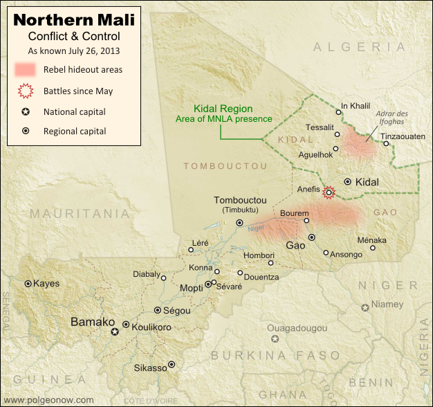
Updated map of situation in Mali ahead of elections on July 28, 2013. Map by Evan Centanni, modified from Wikimedia map by Orionist, using images by Carport and NordNordWest (source). License: CC BY-SA.

Saturday, July 20, 2013

Nigeria Map Update: War on Boko Haram Continues After Decline in Rebel Control

There are newer versions of this map available. To see them, view all Nigeria updates.

Two months ago, Political Geography Now published a map of Boko Haram rebel control in Nigeria as the government declared a state of emergency and began a large-scale military intervention. We now present an updated map of the continued fighting and attacks following the rebels' apparent loss of any significant territorial control.
Map of battles, government raids, and rebel attacks in Nigeria's war with Boko Haram and declared state of emergency. Updated for July 2013.
Map of fighting and attacks in Nigeria's war against the rebels of Boko Haram. Map by Evan Centanni.

Tuesday, June 25, 2013

Syria Civil War Map: June 2013 (#10)

There are newer versions of this map available. To see them, view all Syria updates.

Since March, large-scale violence has continued in Syria. Despite this, no major cities have changed hands - yet there have been important changes to control of smaller towns in two different regions. Here's the updated conflict map, plus a summary of recent territorial changes.

Map of rebel activity and control in Syria's Civil War (Free Syrian Army, Kurdish groups, Al-Nusra Front and others), updated for June 2013. Includes recent locations of conflict and violence, including the Qusayr, Golan Heights, Daraa, Dael, and Baida.
Activity and cities held by rebels and other groups in Syria, updated for June 2013. Map by Evan Centanni, starting from this blank map by German Wikipedia user NordNordWest. License: CC BY-SA