 |
| Map by Evan Centanni, from blank map by Ssolbergj. License: CC BY-SA |
Updates on the world's countries and borders
Showing posts with label europe. Show all posts
Showing posts with label europe. Show all posts
Friday, March 27, 2020
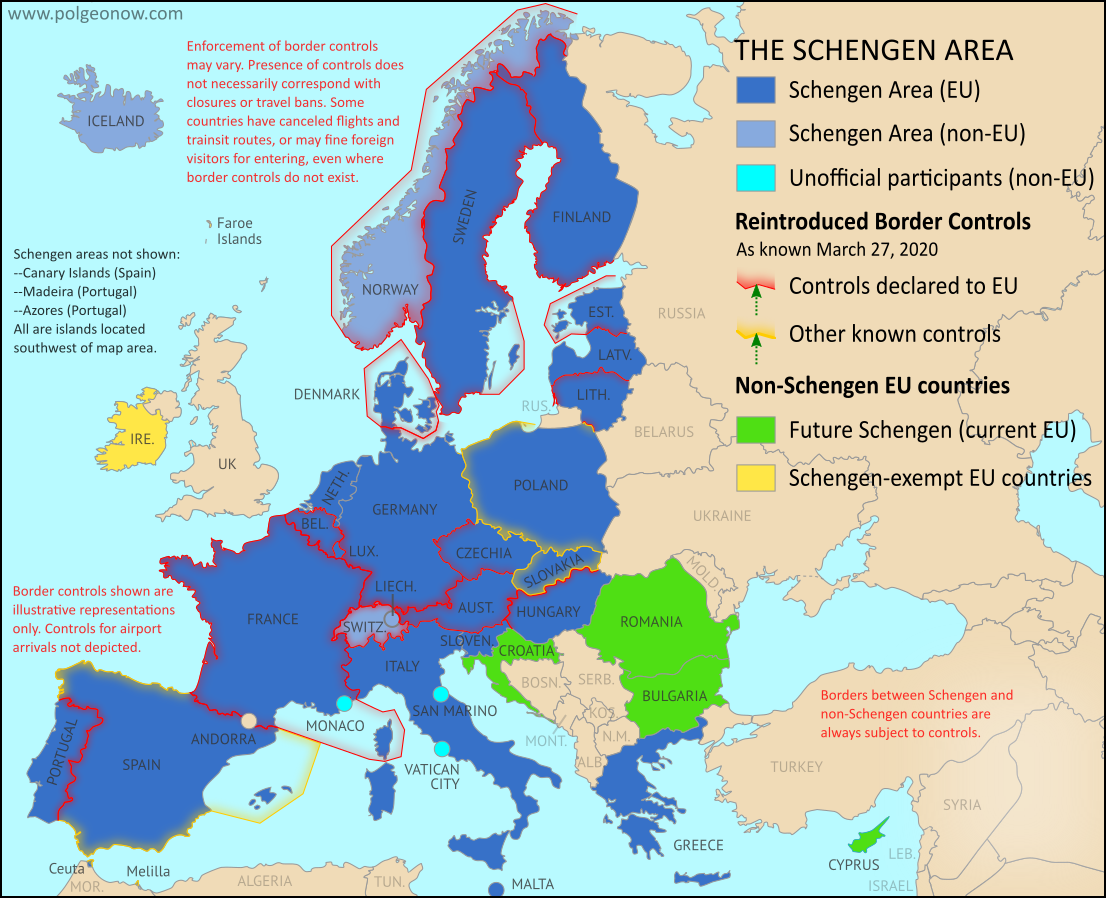
Schengen Border Controls in the Time of Coronavirus (March 27, 2020)
This is an older edition of our Schengen Area border controls map, preserved here with its accompanying timeline for the historical record. To read the full article and see the current map and country-by-country list of border controls, visit our updated Schengen border controls article.
Article by Evan Centanni
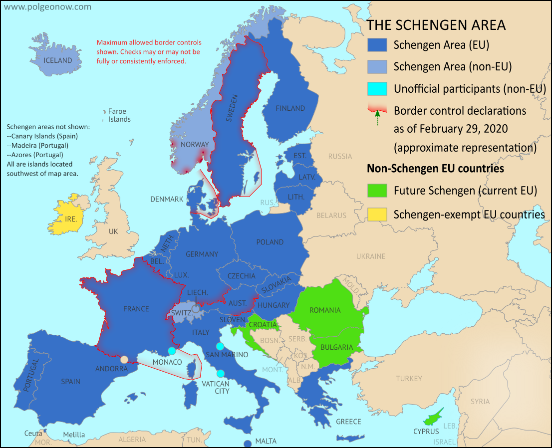
Map: Schengen Border Controls Before Coronavirus (2017-2020)
We mapped reinstated border controls within Europe's Schengen free travel area in March 2016, August 2016, February 2017, and August 2017, amid the past half-decade's surge of new refugee and immigrant arrivals. This article chronicles the history of the border checks from 2017 until just before the coronavirus pandemic of 2020. See the companion piece to this article for border controls during the coronavirus outbreak.
Article by Evan Centanni
 |
Changes to the way France is depicted compared to the previous map represent a stylistic adjustment, and not a change to the actual situation. Map by Evan Centanni, from blank map by Ssolbergj. License: CC BY-SA |
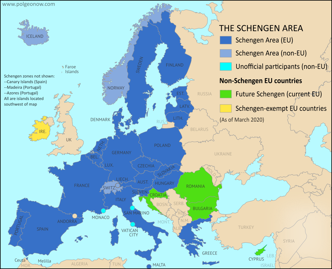
Border Controls Between Schengen Countries
As anyone who's visited Europe in recent decades knows, much of the continent is linked together as part of the "Schengen Area", a collection of countries that don't make travelers show any ID to cross back and forth across the borders between them - just walk on in (this system is overseen by the European Union, but the Schengen Area and the EU aren't the same thing). Though these borders are supposed to stay unregulated most of the time, the system does allow countries to temporarily reintroduce border controls under certain circumstances.Map of the Schengen Area, Europe's Border-free Travel Zone
Editor's Note: As of January 2023, the Schengen Area now includes Croatia. The map and article below will soon be updated to reflect this.
What is the "Schengen Area"? What's the difference between Schengen and the EU? And which countries does Schengen include? Read on for all the answers, explained in plain English!
Important note: Though borders within the Schengen Area are normally completely open, countries can sometimes bring back temporary (or even long-term) ID checks. You can check for recent maps of the situation by viewing all Schengen border control articles on PolGeoNow. This is especially true during the 2020 global coronavirus pandemic, when many countries have not only brought back border controls, but are also turning away foreign travelers.
 |
| Map by Evan Centanni, from blank map by Ssolbergj. License: CC BY-SA |
Saturday, February 8, 2020
Brexit: UK Leaves European Union (Plus: What Actually Changed?)
 |
Map by Evan Centanni, from blank map by Ssolbergj. License: CC BY-SA |
Britain Finally Exits EU
Last week, the United Kingdom of Great Britain and Northern Ireland - "UK" or "Britain" for short - became the first country ever to formally leave the European Union (EU).This marks the turning point, but not the end, of the years-long saga nicknamed "Brexit" (short for "British exit"), which started with a 2016 referendum.
The long-delayed official exit finally arrived in the first second of February 1, 2020 at the EU headquarters in Belgium. Because of a time zone difference, this was 11:00 pm of January 31 in the UK. But because of a negotiated "transition period", most practical changes won't go into effect until at least the end of this year (read on for more about that).
The British territory of Gibraltar, located along the southern coast of Spain, was also pulled out of the EU alongside the UK.
How it Happened: A Concise Timeline of Brexit
|
Map by Evan Centanni, from blank map by Ssolbergj. License: CC BY-SA |
UK Leaves EU: What Were They Doing All That Time?
Last week, the UK actually left the European Union, in a long-anticipated move called for by a referendum vote in 2016. This British exit, or "Brexit" was never meant to happen in less than two years - by how did it stretch out to almost four?We've put together a clear and concise timeline summarizing the process, without any of the confusing technical lingo or agonizing political details. Enjoy!
Friday, February 7, 2020
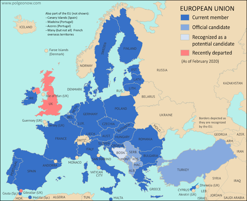
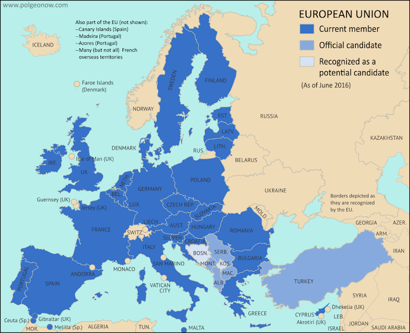
Map: Which Countries were in the European Union in 2020, Which Weren't, and Which Wanted to Join?
There are newer versions of this article and map available. You can always find the latest version at this link: Which Countries are in the European Union?
The UK has finally officially left the European Union (EU), almost four years after its famous "Brexit" vote, and taken the British territory of Gibraltar out with it. Here's our updated map and list of which countries are in the EU, which ones are trying to join, and which European countries are in neither group.
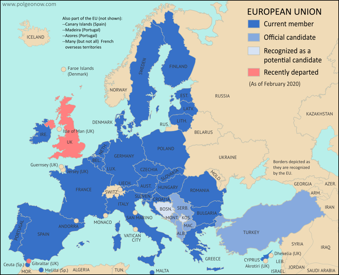 |
| The European Union after the January 2020 departure of the UK and Gibraltar (pre-Brexit version here). Map by Evan Centanni, from blank map by Ssolbergj. License: CC BY-SA |
Monday, February 18, 2019
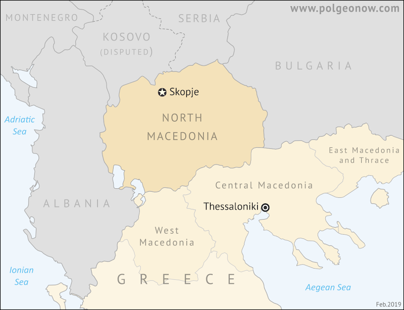
"North Macedonia" Name Change Goes Into Effect
 | |
| North Macedonia is "north" because most of historical Macedonia was south of it, in what's now Greece. (Contact us for permission to use this map.) |
North Macedonia: New Name Adopted
Last Tuesday, the controversially-named Republic of Macedonia - also known as the "former Yugoslav Republic of Macedonia" (FYROM) - officially become the Republic of North Macedonia. The changed entered into force exactly eight months after the country first made a deal with Greece to end their naming and identity dispute.Saturday, October 6, 2018
"North Macedonia" Vote Not All About Country Name
 | |
| Besides the controversially-named Republic of Macedonia (FYROM), Greece has three Macedonia provinces too. Contact us for permission to use this map. |
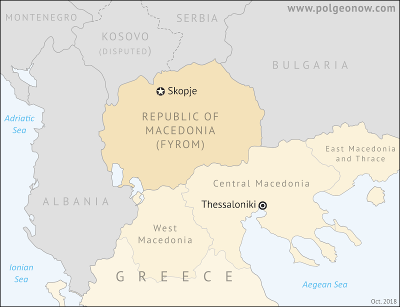
Referendum in the Republic of Macedonia (FYROM)
Last Sunday, people in Southeastern Europe's Republic of Macedonia - also known as FYROM, an acronym for "former Yugoslav Republic of Macedonia" - voted on whether to approve a recent deal signed with Greece. The deal famously includes changing the country's name to "Republic of North Macedonia", but it's actually about a lot more than that.For the details on the referendum and its results, check out our companion article: What Happened in the "North Macedonia" Referendum?
What Happened in the "North Macedonia" Referendum?
| |
| Besides the controversially-named Republic of Macedonia (FYROM), Greece has three Macedonia provinces too. Contact us for permission to use this map. |
Referendum in the Republic of Macedonia (FYROM)
Last Sunday, people in Southeastern Europe's Republic of Macedonia - also known as FYROM, an acronym for "former Yugoslav Republic of Macedonia" - voted on whether to approve a recent deal signed with Greece.The deal famously includes changing the country's name to "Republic of North Macedonia", though that's not all it's about.
The question on the ballots was:
Friday, September 28, 2018
"Macedonia": Why is a Name So Important?
 | |
| Ancient definitions of Macedonia compared with modern borders. Contact us for permission to use this map. |
What's in a Name? The "Macedonia" Dispute
This Sunday, Southeastern Europe's Republic of Macedonia is voting on a deal with Greece that includes changing its name to "Republic of North Macedonia". Greece objects to its neighbor using the name "Macedonia", and has been locked in a bitter dispute over it ever since the smaller country declared independence from Yugoslavia in 1991.The spat is serious enough that the Republic of Macedonia has been forced to accept the temporary name "former Yugoslav Republic of Macedonia" (FYROM) in the UN and other international organizations for the past 25 years, and has been blocked entirely from joining the European Union and NATO, where Greece holds veto power on new member applications.
Saturday, October 28, 2017
Catalonia Declares Independence from Spain: What Now?
This report is part of our Referendum 2017 coverage, spotlighting disputed independence votes for Kurdistan in Iraq and Catalonia
in Spain, plus less-controversial self-rule referendums in three areas of Italy.
By Evan Centanni
Declaration of Catalan Independence
Catalonia, a self-governed region within Spain, has declared an independent "Catalan Republic" nearly a month after holding a controversial independence vote, despite powerful opposition from the Spanish government.
The declaration was made on Friday, October 27, after the region's parliament - elected legally under the Spanish constitution but now defying it - voted 70-10 in favor of independence. Anti-independence parties boycotted the vote, but 70 votes is enough that the motion would have passed either way, since the body has a total of 135 members.
 |
| Map by Evan Centanni, based on this map by Mutxamel. License: CC BY-SA |
Declaration of Catalan Independence
Catalonia, a self-governed region within Spain, has declared an independent "Catalan Republic" nearly a month after holding a controversial independence vote, despite powerful opposition from the Spanish government.The declaration was made on Friday, October 27, after the region's parliament - elected legally under the Spanish constitution but now defying it - voted 70-10 in favor of independence. Anti-independence parties boycotted the vote, but 70 votes is enough that the motion would have passed either way, since the body has a total of 135 members.
Sunday, October 22, 2017
Referendum 2017: Three Autonomy Votes in Italy Today
This report is part of our Referendum 2017 coverage, spotlighting votes on the political status of Kurdistan in Iraq, Catalonia in Spain, and now three areas of Italy. However, these latest votes are much different from the controversial ones we've covered in the last month...
Update: All three referendums have passed. In Lombardy, 95% of participating voters favored autonomy, but with only 39% turnout; and in Veneto, autonomy won support from 98% of voters with 57% turnout, meeting the minimum 50% turnout requirement. Nearly 99% of participants in Belluno province supported autonomy within the Veneto region, with 52% turning out to vote.
A third referendum is happening in the province of Belluno, part of the Veneto region, on whether to ask for more self-rule from the regional government in Venice. Belluno is a mountainous province at the northern end of the Veneto region, sharing a border with Austria.
Update: All three referendums have passed. In Lombardy, 95% of participating voters favored autonomy, but with only 39% turnout; and in Veneto, autonomy won support from 98% of voters with 57% turnout, meeting the minimum 50% turnout requirement. Nearly 99% of participants in Belluno province supported autonomy within the Veneto region, with 52% turning out to vote.
 |
| Map by Evan Centanni, based on blank map by TUBS and NordNordWest (Wikimedia Commons). License: CC BY-SA |
Where are referendums happening?
Referendums are being conducted today in two of Italy's top level "regions" (something in between a province and a US-style state). Both of them are located in the north of the country: Lombardy, which includes the city of Milan, and Veneto, which includes the city of Venice. These two regions are voting on whether to negotiate increased self-rule with the Italian national government through a framework set out in the constitution.A third referendum is happening in the province of Belluno, part of the Veneto region, on whether to ask for more self-rule from the regional government in Venice. Belluno is a mountainous province at the northern end of the Veneto region, sharing a border with Austria.
Friday, October 13, 2017
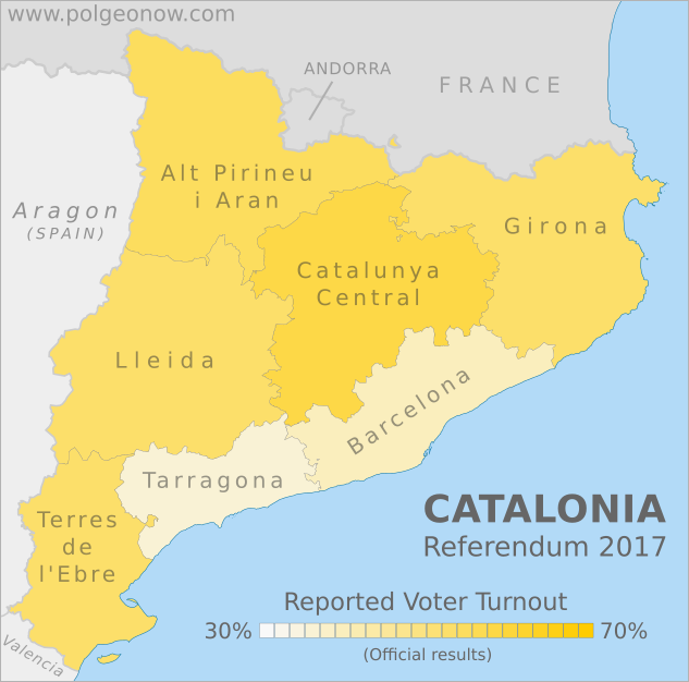
Catalonia Referendum: Detailed Results in 5 Maps
This map report is part of our Referendum 2017 coverage, spotlighting controversial independence votes in two of the world's autonomous regions: Kurdistan voted for independence from Iraq last month, and Catalonia tried to vote on leaving Spain on Oct. 1. Now we've mapped out Catalonia's results in detail based on data from the regional government.
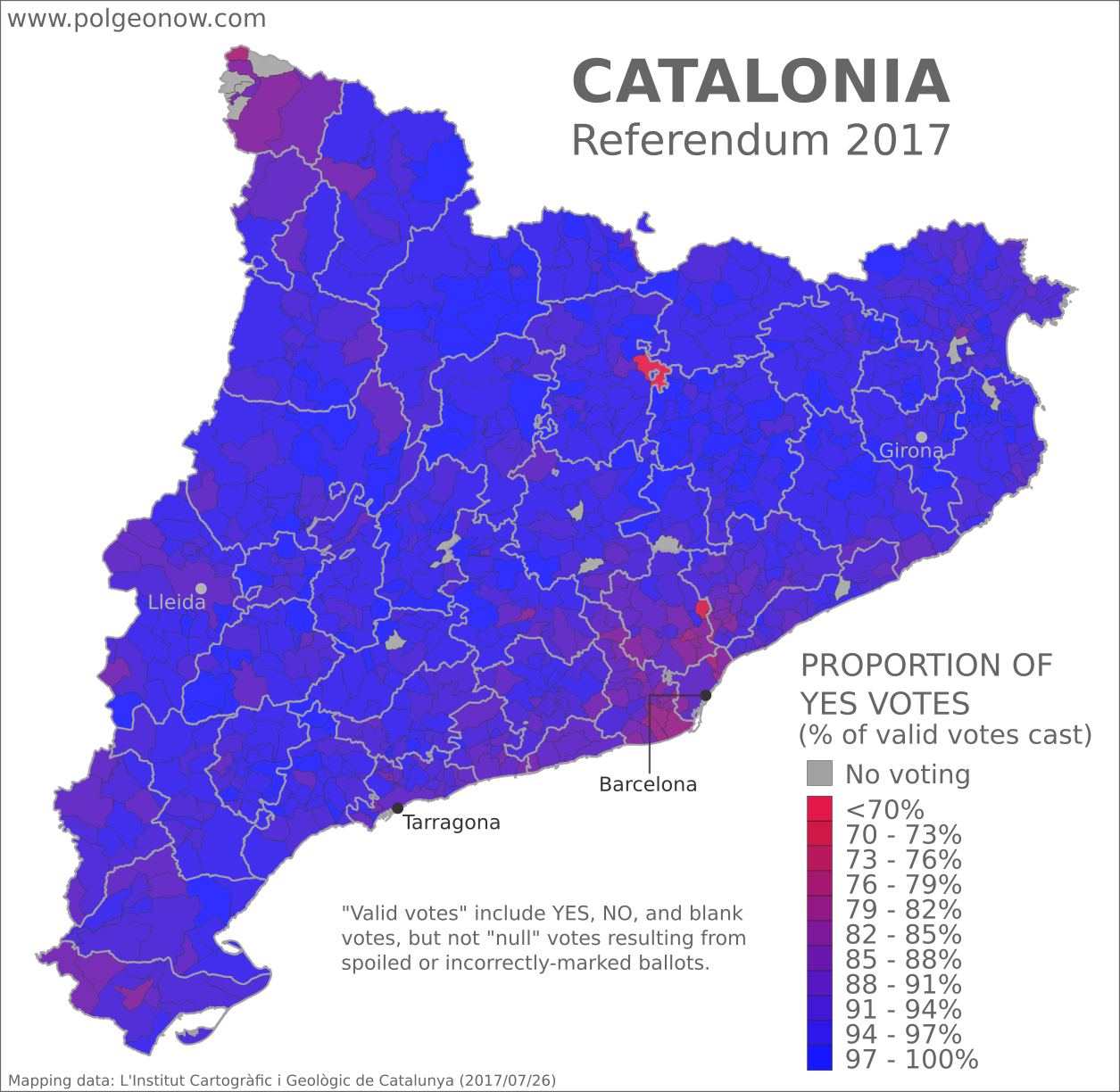
Controversial Independence Vote
On October 1, Spain's autonomous region of Catalonia tried to hold a referendum on independence from Spain. After Spanish courts ruled the vote illegal, Spanish national police attempted to prevent voting, and the result was that voting was disrupted in many areas and not organized properly in most others. Still, Catalan government data states that some 42% of the region's residents came out to vote anyway, and of those who did, about 90% voted in favor of secession. Though Catalonia's president had promised to declare independence within 48 hours of a YES victory, so far he's delayed doing so.Saturday, October 7, 2017
Updated! Catalonia Referendum Results Maps: How Did Each Region Vote?
Updated! This article's maps and text have been updated with final results released by the Catalan government. See below for more details. We also now have an article with detailed results maps broken down by municipality.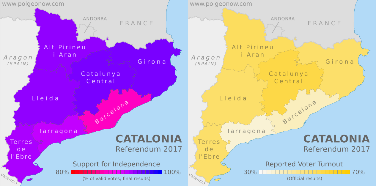
This map report is part of our Referendum 2017 coverage, spotlighting controversial independence votes in two of the world's autonomous regions: Kurdistan voted for independence from Iraq last week, and Catalonia voted to leave Spain this weekend. Now detailed results are available, and we're working on getting them mapped out.
This map report is part of our Referendum 2017 coverage, spotlighting controversial independence votes in two of the world's autonomous regions: Kurdistan voted for independence from Iraq last week, and Catalonia voted to leave Spain this weekend. Now detailed results are available, and we're working on getting them mapped out.
 |
 |
| Maps by Evan Centanni, starting from blank map by Vinals and Rwxrwxrwx. License: CC BY-SA | |
Catalonia Independence Vote (Updated)
Detailed, final results are now available for Catalonia's controversial referendum on independence from Spain. The vote was widely disrupted by the Spanish police after courts ruled it illegal, resulting in massive irregularities that will make it hard for outsiders to accept as a proper democratic referendum. Still, some 43% of eligible Catalan voters reportedly made it out to cast ballots, meaning there's plenty of reported data to look at.Saturday, September 30, 2017
Catalonia Voting on Independence: What Will Happen?
This article is part of our Referendum 2017 coverage, spotlighting controversial independence votes in two of the world's autonomous regions: Kurdistan voted for independence from Iraq this Monday, and Catalonia is about to vote on leaving Spain.
Update: Check out the bottom of the article for a brief summary of what's actually happened since referendum day!
By Evan Centanni
Update: Check out the bottom of the article for a brief summary of what's actually happened since referendum day!
|
| Map by Evan Centanni, based on this map by Mutxamel. License: CC BY-SA |
Catalonia Independence Vote
Catalonia, a self-governed region within Spain, is about to start voting on independence in a referendum that Spanish courts have ruled illegal. So what will happen? No one really knows, but we've taken our best shot at answering six of the big questions...Referendum 2017: What is Catalonia?
This article is part of our Referendum 2017
coverage, spotlighting controversial independence votes in two of the
world's autonomous regions: Kurdistan voted for independence from Iraq this Monday, and Catalonia will vote Sunday on leaving Spain.
The following article is adapted from one originally published in 2013.
By Omar Alkhalili, with additional reporting by Evan Centanni
The following article is adapted from one originally published in 2013.
|
| Map by Evan Centanni, based on this map by Mutxamel. License: CC BY-SA |
Not Independent Yet: So What is Catalonia Now?
Catalonia is one of the "autonomous communities" of Spain (kind of like a state in the US), and also holds the official status of a "nationality" (but not "nation") within the Spanish system of government. Regions of Spain with this status are considered to be something similar to countries within the larger Spanish nation, allowing for their own separateness from Spanish mainstream culture without actually being independent.Tuesday, August 1, 2017
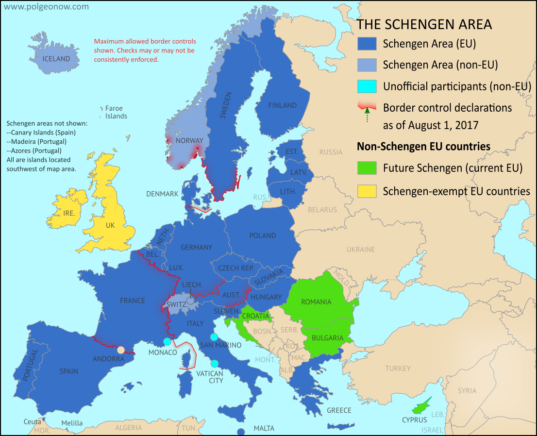
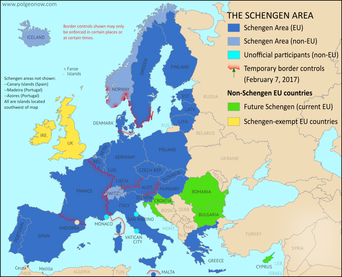
Map: Which Schengen Borders are Closed to Passport-Free Travel in August 2017?
There are newer versions of this map available. To see them, view all Schengen Area articles.
Last year, we explained Europe's Schengen free travel area in plain English, then published maps of which European countries had temporarily reintroduced border controls as of March 2016, August 2016, and February 2017. Here's an update and summary for August of 2017.
Article by Evan Centanni
Last year, we explained Europe's Schengen free travel area in plain English, then published maps of which European countries had temporarily reintroduced border controls as of March 2016, August 2016, and February 2017. Here's an update and summary for August of 2017.
 |
| Map by Evan Centanni, from blank map by Ssolbergj. License: CC BY-SA |
Current Border Controls Between Schengen Countries
As anyone who's visited Europe in recent decades knows, much of the continent is linked together as part of the "Schengen Area", a collection of countries that don't make travelers show any ID to cross back and forth across their borders (though this system is overseen by the European Union, the Schengen Area and the EU aren't the same thing). But the system does allow countries to temporarily reintroduce border controls under certain circumstances.Friday, June 23, 2017
Why Brexit Matters: 5 Things That Might Change When Britain Leaves the EU
By Bryn Jansson
UK voters’ surprise choice to leave the EU happened exactly a year ago, on June 23, 2016 - but it didn’t automatically trigger the two-year countdown clock on exit negotiations necessary for departure under Article 50 of the EU’s Lisbon Treaty.
 |
| Map of current and future EU member countries |
Brexit Process Finally Begins
The United Kingdom (UK) and the European Union (EU) began formal divorce negotiations in Brussels last Monday, June 19, starting a 21-month sprint to the March 2019 Brexit deadline. ("Brexit" is short for "British Exit" from the EU, since "Britain" is another name for the UK.)UK voters’ surprise choice to leave the EU happened exactly a year ago, on June 23, 2016 - but it didn’t automatically trigger the two-year countdown clock on exit negotiations necessary for departure under Article 50 of the EU’s Lisbon Treaty.
Tuesday, February 7, 2017
Schengen Border Controls in February 2017: Map of Free Travel Restrictions
There are newer versions of this map available. To see them, view all Schengen Area articles.
Last year, we explained Europe's Schengen free travel area in plain English, then published maps of which European countries had temporarily reintroduced border controls as of March 2016 and August 2016. We now present an updated map and summary of the situation.
(Subscribers click here to view this article in the members area.)
Article by Evan Centanni
Last year, we explained Europe's Schengen free travel area in plain English, then published maps of which European countries had temporarily reintroduced border controls as of March 2016 and August 2016. We now present an updated map and summary of the situation.
 |
| Map by Evan Centanni, from blank map by Ssolbergj. License: CC BY-SA |
Article by Evan Centanni
Changes to Schengen Border Controls Since 2016
As anyone who's visited Europe in recent decades knows, much of the continent is linked together as part of the "Schengen Area", a collection of countries that don't make travelers show any ID to cross back and forth across their borders (though this system is overseen by the European Union, the Schengen Area and the EU are not the same thing). But the system does allow countries to temporarily reintroduce border controls under certain circumstances.Tuesday, December 27, 2016
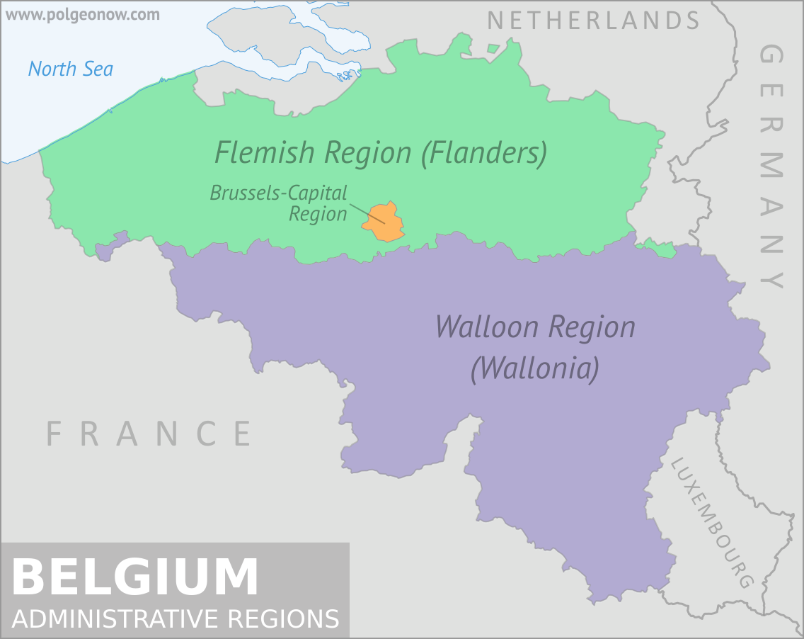
What is Wallonia? Belgium's Unusual Federal System
(Subscribers click here to view this article in the members area.)
By Bryn Jansson
Yet there it was this October, caught in the middle of a European political drama, the lone holdout of the EU-28 against the Comprehensive Economic and Trade Agreement (CETA), a large scale free-trade deal with Canada. Even more amazingly, it wasn’t even the whole of Belgium blocking the trade deal, but only the sub-region of Wallonia, home to 32 percent of Belgians (known as “Walloons”) and less than 1 percent of EU citizens.
 |
 |
| Maps by Evan Centanni, from base map by Vascer (CC BY-SA) |
Wallonia vs. the European Union
Belgium often seems like an afterthought in European politics. It doesn’t have the economic clout of a Germany, the political influence of a France, or the military power of a Britain. It’s a small country tucked into the northwest corner of Europe, and known mostly for its chocolate and beer (though the acclaim both have earned is well-deserved). It’s home to the European Union headquarters in Brussels, but otherwise holds no special political power in the for-now 28-nation bloc.Yet there it was this October, caught in the middle of a European political drama, the lone holdout of the EU-28 against the Comprehensive Economic and Trade Agreement (CETA), a large scale free-trade deal with Canada. Even more amazingly, it wasn’t even the whole of Belgium blocking the trade deal, but only the sub-region of Wallonia, home to 32 percent of Belgians (known as “Walloons”) and less than 1 percent of EU citizens.
Subscribe to:
Posts (Atom)