 |
| Map by Evan Centanni, from public domain blank map. |
Updates on the world's countries and borders
Showing posts with label africa. Show all posts
Showing posts with label africa. Show all posts
Thursday, July 28, 2016
Map: Liberia and Afghanistan Join WTO
(Subscribers click here to view this article in the members area.)
Friday, March 18, 2016
Libya Control Map & Report: March 2016 (Subscription)
MEMBERS CLICK HERE TO PROCEED TO ARTICLE AND MAP
There are newer versions of this map available. To see them, view all Libya updates.
Map by onestopmap.com and Evan Centanni
 Despite hopes that a UN-backed unity deal might bring Libya's two rival governments back together, fighting in continues against the so-called "Islamic State" (ISIS/ISIL) and other religious hardline groups. Though most of the major cities have stayed in the same hands since last summer, there have still been several important changes to territorial control.
See all this and more on the latest update to PolGeoNow's concise, professional Libyan Civil War control map, which comes with a timeline of changes since our previous Libya map report last August.
This map and report are professional subscriber content, available to paid members or for separate purchase. Download PDF (US$9.99)
Want to see before you buy? Check out our most recent FREE SAMPLE Libya map!
Exclusive Libya map report includes:

MEMBERS CLICK HERE TO PROCEED TO ARTICLE AND MAP
Not a member yet? Click here to learn more about our professional subscription service!
There are newer versions of this map available. To see them, view all Libya updates.
Map by onestopmap.com and Evan Centanni
New: No Paypal account required! Just click "Pay using your credit or debit card." Download PDF: Buy now |
Despite hopes that a UN-backed unity deal might bring Libya's two rival governments back together, fighting in continues against the so-called "Islamic State" (ISIS/ISIL) and other religious hardline groups. Though most of the major cities have stayed in the same hands since last summer, there have still been several important changes to territorial control.See all this and more on the latest update to PolGeoNow's concise, professional Libyan Civil War control map, which comes with a timeline of changes since our previous Libya map report last August.
This map and report are professional subscriber content, available to paid members or for separate purchase. Download PDF (US$9.99)
Want to see before you buy? Check out our most recent FREE SAMPLE Libya map!
Exclusive Libya map report includes:
- Up-to-date map of current territorial control in Libya, color-coded for the internationally-recognized Tobruk government (supported by General Haftar's Operation Dignity), the rival Tripoli-based GNC government (supported by the Libya Dawn militias), "Islamic State" (ISIS/ISIL) extremists, and other religious hardline groups.
- Detailed indication of city-by-city control, highlighting key towns and other locations important to current events.
- Locations of recent fighting and military operations, including Benghazi, Ajdabiya, Janzur, Bin Jawad, and more.
- Detailed timeline of important events and changes to territorial control since August 21, 2015, with all sources cited.
- New in this edition: Major roads are marked on the map for reference
MEMBERS CLICK HERE TO PROCEED TO ARTICLE AND MAP
Not a member yet? Click here to learn more about our professional subscription service!
Friday, November 6, 2015
The Death of a Currency: Zimbabwe Dollar Demonetized
Premium members click here to view this article in the ad-free members area. Not a member yet? Learn about our subscription service!

By Olga Rodriguez-Walmisley, with additional reporting by Evan Centanni
The End of the Zimbabwe Dollar
As of last month, the Zimbabwe dollar (Z$) no longer has any monetary value: After more than a decade of extreme inflation, it has been permanently retired. It was the official currency of Zimbabwe for 29 years, from 1980 to 2009, and continued to be circulated until this past September. Today, the government of Zimbabwe uses US dollars, while at least seven other foreign currencies are also accepted as legal tender: the South African rand, Botswana pula, British pound, Indian rupee, Chinese yuan, Japanese yen, and Australian dollar.
Friday, October 16, 2015
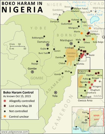
Map of Boko Haram/"Islamic State" Control in Nigeria: October 2015
(To see other maps in this series, view all Boko Haram updates on PolGeoNow.)
(Subscribers click here to view this article in the member area)
By Evan Centanni
The "Islamic State" in Nigeria
Northeastern Nigeria's Boko Haram rebels, despite being pushed out of most of the territory they held last year, are still a major force in the region.
After becoming an official affiliate of Iraq and Syria's so-called "Islamic State" (IS, a.k.a ISIS/ISIL) last March, they have now taken to calling themselves the Islamic State's West Africa Province (ISWAP).
 |
| Map by Evan Centanni. All rights reserved. |
By Evan Centanni
The "Islamic State" in Nigeria
Northeastern Nigeria's Boko Haram rebels, despite being pushed out of most of the territory they held last year, are still a major force in the region.
After becoming an official affiliate of Iraq and Syria's so-called "Islamic State" (IS, a.k.a ISIS/ISIL) last March, they have now taken to calling themselves the Islamic State's West Africa Province (ISWAP).
Friday, October 9, 2015
African Union Suspends Burkina Faso, Then Reinstates it Again (Map)
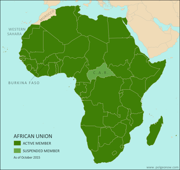 |
| Map by Evan Centanni, from this blank map by Eric Gaba. License: CC BY-SA |
Article by Evan Centanni
Coup Crisis
On September 18, Burkina Faso was suspended from the African Union (AU) by the organization's Peace and Security Council. The action was in response to a government takeover by soldiers loyal to the country's former president Blaise Compaore, who was pushed out in a popular uprising a year ago.
Saturday, August 22, 2015
War in Libya: Map of Control in August 2015
There are newer versions of this map available. To see them, view all Libya updates.
This is the first of a series of professional Libya control maps. Secure your access to future updates: sign up now for our conflict map subscription service!
Subscribers click here to view this article in the ad-free members area. Not a member yet? Subscribe now!
Background summary by Djordje Djukic; timeline by Evan Centanni and T.H.
Included in this free article:
This is the first of a series of professional Libya control maps. Secure your access to future updates: sign up now for our conflict map subscription service!
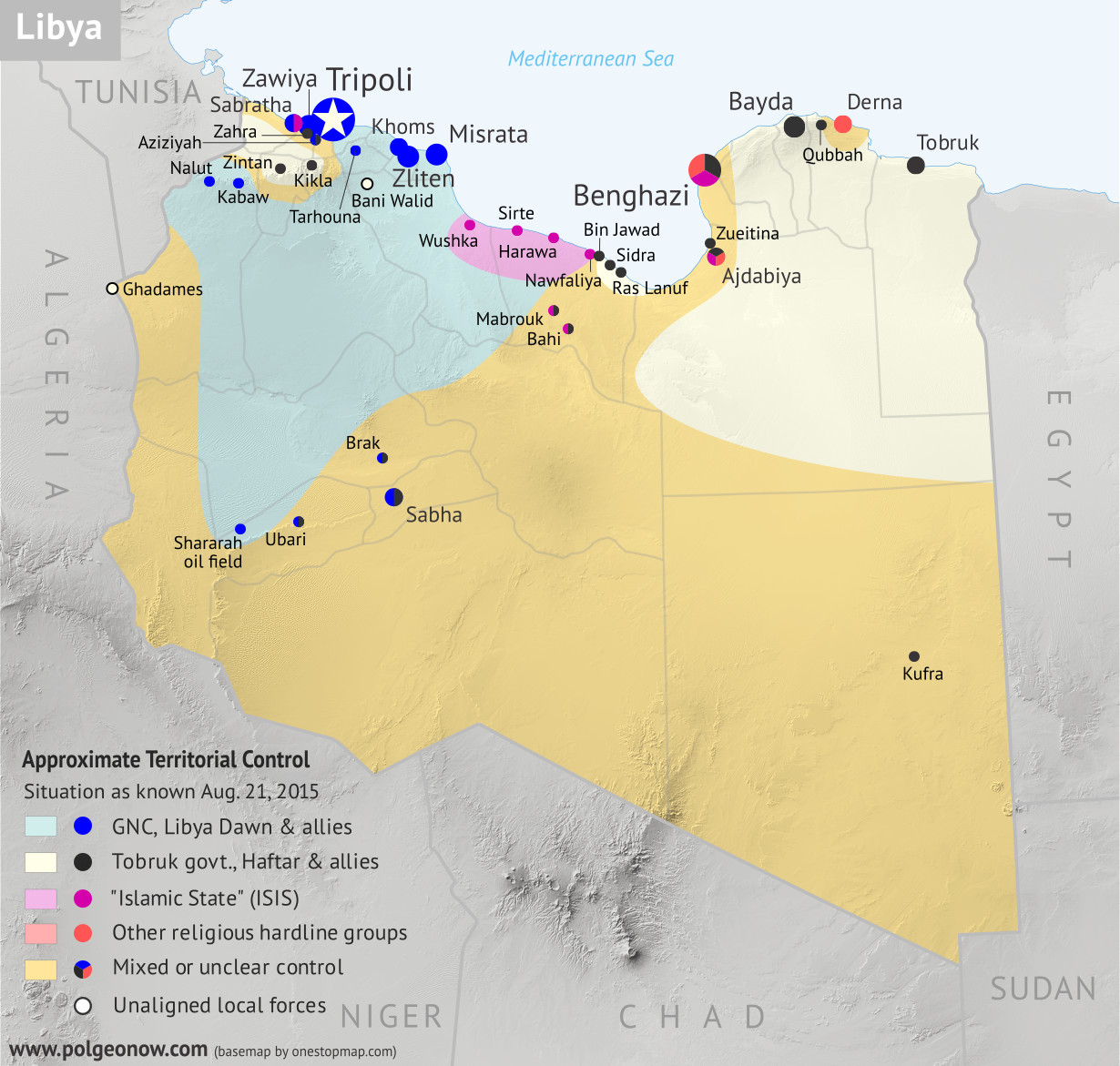 |
Base map by Koen Adams of onestopmap.com, with territorial control by Evan Centanni. All rights reserved.
|
Subscribers click here to view this article in the ad-free members area. Not a member yet? Subscribe now!
Background summary by Djordje Djukic; timeline by Evan Centanni and T.H.
Included in this free article:
- Concise summary of events in Libya since the fall of Muammar Gaddafi in 2011
- Detailed timeline of conflict, changes to territorial control, and political events since 2011, with each mentioned location illustrated on the map above
Friday, August 7, 2015
New Olympic Nation: South Sudan (Map)
Paid subscribers click here to view this article in the ad-free members area. Not a member yet? Subscribe now!
 |
| Map of all nations in the Olympics, and their regional associations. Two newest Olympic nations labeled. Map by Evan Centanni, starting from this blank map and modeled after this map. |
Wednesday, June 10, 2015
Map of Rebel Control in Mali: June 2015
(To see other maps in this series, view all Mali articles.)
Subscribers click here to view this article in the ad-free members area. Not a member yet? Subscribe now!
Article by Evan Centanni
Separatist Return to Power
At the time of our last Mali rebel control map report, separatist rebels had just allowed the Malian government to resume control of the north as part of a ceasefire agreement ahead of elections. The rebels had for a time resumed control of the region after a French-led military intervention pushed out the religiously-oriented rebel groups who had usurped the initial separatist rebellion. In July 2013, Mali's territory was again united for the first time in over a year.
 |
Map by Evan Centanni, modified from this map by Orionist, Carport, and NordNordWest. License: CC BY-SA.
|
Article by Evan Centanni
Separatist Return to Power
At the time of our last Mali rebel control map report, separatist rebels had just allowed the Malian government to resume control of the north as part of a ceasefire agreement ahead of elections. The rebels had for a time resumed control of the region after a French-led military intervention pushed out the religiously-oriented rebel groups who had usurped the initial separatist rebellion. In July 2013, Mali's territory was again united for the first time in over a year.
Thursday, May 28, 2015
Map of Boko Haram Control in Nigeria: May 2015 (Subscription)
The best online map of Boko Haram's territorial control - guaranteed!
There are newer versions of this map available. To see them, view all Boko Haram updates.

Timeline by T.H., with additional reporting by Evan Centanni
Even as evidence mounts of Boko Haram's ties to the Islamic State, the Nigerian rebel group has been driven from most of its recently-held territory. Yet as Nigeria's new president prepares to take office, Boko Haram may already be making a comeback.
This map report illustrates areas of known and possible Boko Haram control in Nigeria, and for the first time shows the full area of the Sambisa Forest, the rebels' last-resort hideout. The report includes a summary and timeline of events since our previous Boko Haram control map in March.
This map report is exclusive premium content, available to paid subscribers or for separate purchase. Buy now (US$14.99)
Exclusive map report includes:
MEMBERS CLICK HERE TO PROCEED TO ARTICLE AND MAP
NOT A MEMBER YET? SUBSCRIBE NOW!
There are newer versions of this map available. To see them, view all Boko Haram updates.

Download PDF: Buy now |
Even as evidence mounts of Boko Haram's ties to the Islamic State, the Nigerian rebel group has been driven from most of its recently-held territory. Yet as Nigeria's new president prepares to take office, Boko Haram may already be making a comeback.
This map report illustrates areas of known and possible Boko Haram control in Nigeria, and for the first time shows the full area of the Sambisa Forest, the rebels' last-resort hideout. The report includes a summary and timeline of events since our previous Boko Haram control map in March.
This map report is exclusive premium content, available to paid subscribers or for separate purchase. Buy now (US$14.99)
Exclusive map report includes:
- Map of Boko Haram's overall area of control in Nigeria, updated to May 28, 2015.
- Detailed mapping of each town under Boko Haram's influence, as well as most locations of recent attacks.
- New: Full outline of the Sambisa Forest, Boko Haram's vast safe haven.
- Summary and detailed timeline of territorial changes and major events since late March, with links to sources.
MEMBERS CLICK HERE TO PROCEED TO ARTICLE AND MAP
NOT A MEMBER YET? SUBSCRIBE NOW!
Thursday, April 30, 2015
Map: Seychelles Join WTO
Paid subscribers click here to view this article in the ad-free members area. Not a subscriber yet? Subscribe now!
 |
| Member and observer states of the World Trade Organization (WTO). Map by Evan Centanni, starting from public domain blank map (license: CC BY-NC-SA). |
Monday, March 23, 2015
Map of Boko Haram Control in Nigeria: March 2015 (Subscription)
The best online map of Boko Haram's territorial control - guaranteed!
There are newer versions of this map available. To see them, view all Boko Haram updates.

Research by T.H., with additional reporting by Evan Centanni
Boko Haram has now allegedly teamed up with the Islamic State, but the Nigerian rebel group has recently lost most of its territory to a multi-pronged military campaign involving Nigeria, Chad, Niger, and Cameroon.
This map report illustrates the offensive against Boko Haram and the rebel group's remaining territorial holdings, and includes a summary and timeline of events since our previous Boko Haram map report in January.
This map report is exclusive premium content, available to paid subscribers or for separate purchase. Buy now (US$14.99)
Exclusive map report includes:
MEMBERS CLICK HERE TO PROCEED TO ARTICLE AND MAP
NOT A MEMBER YET? SUBSCRIBE NOW!
There are newer versions of this map available. To see them, view all Boko Haram updates.

Download PDF: Buy now |
Boko Haram has now allegedly teamed up with the Islamic State, but the Nigerian rebel group has recently lost most of its territory to a multi-pronged military campaign involving Nigeria, Chad, Niger, and Cameroon.
This map report illustrates the offensive against Boko Haram and the rebel group's remaining territorial holdings, and includes a summary and timeline of events since our previous Boko Haram map report in January.
This map report is exclusive premium content, available to paid subscribers or for separate purchase. Buy now (US$14.99)
Exclusive map report includes:
- Map of Boko Haram's overall area of control in Nigeria, updated to March 22, 2015.
- Detailed map showing almost every individual town currently or previously held by Boko Haram, as well as the overall extent of rebel territorial control.
- Illustrations of the five major military campaigns that have driven Boko Haram back over the past two months, as well as key locations in neighboring countries.
- Summary and detailed timeline of territorial changes and major events since late January, with links to sources.
MEMBERS CLICK HERE TO PROCEED TO ARTICLE AND MAP
NOT A MEMBER YET? SUBSCRIBE NOW!
Thursday, January 29, 2015
Nigeria War Update: Map of Boko Haram Control (January 2015) (Premium)
The best online map of Boko Haram's territorial control - guaranteed!
There are newer versions of this map available. To see them, view all Nigeria updates.

Research by T.H., with additional reporting by Evan Centanni
Since our last Boko Haram control map update in November, the rebel group has expanded its territorial control in Nigeria, connecting two of its territorial enclaves and occupying a long stretch of the country's international border with Niger, Chad, and Cameroon.
This premium report and map detail the various changes of the past two months, including new Boko Haram conquests as well as key attacks that didn't result in territorial gains. The map also, of course, provides an updated illustration of the full extent of Boko Haram's territorial control.
This map and article are exclusive premium content, available only to paid members or for individual purchase. Buy now (US$9.99)
Premium report includes:
MEMBERS CLICK HERE TO PROCEED TO ARTICLE AND MAP
NOT A MEMBER YET? SUBSCRIBE NOW!
There are newer versions of this map available. To see them, view all Nigeria updates.

Download PDF Buy now |
Since our last Boko Haram control map update in November, the rebel group has expanded its territorial control in Nigeria, connecting two of its territorial enclaves and occupying a long stretch of the country's international border with Niger, Chad, and Cameroon.
This premium report and map detail the various changes of the past two months, including new Boko Haram conquests as well as key attacks that didn't result in territorial gains. The map also, of course, provides an updated illustration of the full extent of Boko Haram's territorial control.
This map and article are exclusive premium content, available only to paid members or for individual purchase. Buy now (US$9.99)
Premium report includes:
- Map of Boko Haram's overall area of control in Nigeria, updated to Jan. 28, 2015.
- Detailed map showing almost every individual town or village known to be held by the group, as well as recent locations of major attacks, such as Baga, Monguno, Maiduguri, and Damataru.
- Also shows attacks across the border in Cameroon.
- Summary and detailed timeline of territorial changes and major events since late November, with sources cited.
MEMBERS CLICK HERE TO PROCEED TO ARTICLE AND MAP
NOT A MEMBER YET? SUBSCRIBE NOW!
Wednesday, November 26, 2014
Nigeria War Update: Map of Boko Haram Control (November 2014) (Premium)
There are newer versions of this map available. To see them, view all Nigeria updates.

Reporting by T.H. and Evan Centanni
Despite short-lived claims of a ceasefire, Nigeria's northern insurgency has continued unabated since late September, when we published our free map of Boko Haram control in Nigeria.
This premium report and map update detail the many changes since then, which have seen Boko Haram's "Islamic Caliphate" grow to control an area the size of Belgium.
This map and article are exclusive premium content, available only to paid members or for individual purchase. Buy now (US$9.99)
Premium report includes:
MEMBERS CLICK HERE TO PROCEED TO ARTICLE AND MAP
NOT A MEMBER YET? SUBSCRIBE NOW!

Download PDF Buy now |
Despite short-lived claims of a ceasefire, Nigeria's northern insurgency has continued unabated since late September, when we published our free map of Boko Haram control in Nigeria.
This premium report and map update detail the many changes since then, which have seen Boko Haram's "Islamic Caliphate" grow to control an area the size of Belgium.
This map and article are exclusive premium content, available only to paid members or for individual purchase. Buy now (US$9.99)
Premium report includes:
- Map of Boko Haram's overall area of control in Nigeria, updated to Nov. 25, 2014.
- Detailed map shows almost every individual town or village known to have been captured by the group, including recent flashpoints like Chibok, Mubi, and Abadam.
- Summary and detailed timeline of territorial changes and major events since late September.
MEMBERS CLICK HERE TO PROCEED TO ARTICLE AND MAP
NOT A MEMBER YET? SUBSCRIBE NOW!
Wednesday, November 19, 2014
Portuguese Community Admits New Member & Observer Countries (Map)
 |
| Map by Evan Centanni, starting from public domain blank map (license: CC BY-NC-SA). |
Monday, September 29, 2014
War in Nigeria: Map of Boko Haram Control (September 2014)
There are newer versions of this map available. To see them, view all Nigeria updates.
Premium members click here to view this article in the ad-free members area. Not a member yet? Sign up now!
Conflict tracking by T.H., with additional reporting by Evan Centanni
Boko Haram vs. Nigeria
Though it's waged a bloody war against the Nigerian government for many years, rebel group Boko Haram rarely could claim significant territorial control until recently. Though they did take over a number of remote areas in spring of last year (see our 2013 Boko Haram control map), the militants were soon driven back into hiding by the Nigerian military.
The insurgency never went away, with Boko Haram's bombings and other attacks, often on schools and other public places, increasing in number and lethality from 2013 into early 2014. (Also see our 2013 report for more background on Boko Haram).
 |
| Map by Evan Centanni. All rights reserved. |
Conflict tracking by T.H., with additional reporting by Evan Centanni
Boko Haram vs. Nigeria
Though it's waged a bloody war against the Nigerian government for many years, rebel group Boko Haram rarely could claim significant territorial control until recently. Though they did take over a number of remote areas in spring of last year (see our 2013 Boko Haram control map), the militants were soon driven back into hiding by the Nigerian military.
The insurgency never went away, with Boko Haram's bombings and other attacks, often on schools and other public places, increasing in number and lethality from 2013 into early 2014. (Also see our 2013 report for more background on Boko Haram).
Tuesday, July 29, 2014
African Union Reinstates Egypt and Guinea-Bissau (Map)
 |
| The African Union as of July 2014. Map by Evan Centanni, from this blank map by Eric Gaba. License: CC BY-SA |
Saturday, May 3, 2014
Mayotte Enters European Union
 |
"Outermost regions" are officially part of the European Union; "overseas countries and territories" are not part of the EU itself, but have special relations with it because of their connections to member countries. New outermost region Mayotte is located in southeastern Africa. Map from Wikimedia Commons © Alexrk2 (CC BY-SA)
|
Article by Evan Centanni
EU Expands to Include Mayotte
You probably heard about Croatia joining the European Union last year, but did you know the EU expanded further this year...in Africa? The French overseas department of Mayotte, a group of islands in the Indian Ocean northwest of Madagascar, became officially part of the EU on January 1.
Tuesday, April 15, 2014
ICYMI: The Gambia's Withdrawal from the Commonwealth
"In case you missed it" - this is an article featuring news we couldn't cover when it first broke, but that we thought you might still want to know about. Those who read our article on the year 2013 in political geography changes already heard about the Gambia's withdrawal from the Commonwealth of Nations - now here's the full story.
Premium members click here to view this article in the ad-free members area. Not a member yet? Subscribe now!
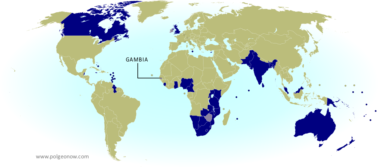 |
| The Commonwealth of Nations. Current members in dark blue, former members in lavender. Map by Evan Centanni, modified from public domain blank map. |
Saturday, March 15, 2014
Madagascar Un-Suspended from African Union
 |
| The African Union as of March 2014. Map by Evan Centanni, from this blank map by Eric Gaba. License: CC BY-SA |
Saturday, February 22, 2014
South Sudan War Map: Current Rebel Control (Update #4) (Premium)

Download PDF buy |
To see the map of control at the time of the ceasefire on January 23, see Part 1.
Premium article includes:
- Exclusive map of current rebel control up to February 21, 2014
- Multiple changes to territorial control since previous update
- Several more new locations added to the map
- Report chronicling changes to territorial control since the ceasefire, including links to sources
Members click here to proceed to article and map
Not a member yet? Subscribe Now!
Subscribe to:
Posts (Atom)