Showing posts with label africa. Show all posts

Monday, November 7, 2011

Libya Reunited Under Rebels

Country Name (official): Libya (English), Lībyā (Arabic)
News Category: Divided Countries
Summary: Libya's civil war came to an end two weeks ago, as rebels under the National Transitional Council (NTC) completed their two-month campaign to flush out the last forces loyal to dictator Muammar Gaddafi. After taking the capital city of Tripoli in August, the NTC had already assumed Libya's seat in the United Nations, the African Union, and the Arab League, with formal recognition from 100 U.N. member states. With the end of the war, the air-based foreign military intervention that helped bring victory to the rebels has also now come to a close.
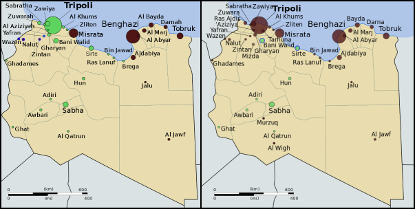
The NTC's last campaigns to reunite Libya. Gaddafi-held cities (green) and
rebel-held cities (black) as of 2 Sep. Rebel movements and capture dates
in red. My own work based on public domain map from Wikipedia (source).

Full Story
Libya's participation in the "Arab Spring" movement happening across the Middle East and North Africa began as a series of protests in February, and quickly transformed into an armed uprising after national leader Muammar Gaddafi responded with violent crackdowns. Soon the country's territory was divided between Gaddafi's government and rebel forces under the National Transitional Council (NTC), with the latter dominating the eastern half of the country as well as the western mountains near Tripoli, the national capital. A near-stalemate held for about five months, as a U.N.-mandated no-fly zone and NATO-led bombing campaign kept Gaddafi's forces at bay. Then, in late August, the rebels suddenly stormed into Tripoli, taking the national capital and many of the surrounding areas. The Gaddafi government only remained in control of a few scattered cities and desert outposts.

See Also: Political Geography Now: Libyan Rebels Take Capital

The NTC's official flag of Libya (bottom) has replaced that
of Gaddafi (top). Public domain, from this Wikipedia page.
For two months following the takeover of Tripoli, the NTC mounted a campaign to drive out the last bastions of Gaddafi loyalist control and reunite the country under their own banner. The first area to fall was the southwestern Fezzan, a desert region with Sabha as its major city, in mid-to-late September. Then came Tripoli's neighbor Bani Walid on 17 October, and finally Gaddafi's hometown of Sirte three days later. As Sirte fell to the rebels, Gaddafi himself was finally captured, and soon died under mysterious circumstances. NTC Chair Mustafa Abdul Jalil declared the war officially over on 23 October. NATO's enforcement and bombing mission ended one week later, following the U.N. Security Council's withdrawal of its authorization for a no-fly zone and military protection of civilians. The rebel victory also brings an end to the dispute over the country's flag (see illustration at left) and its official name, now just "Libya" rather than Gaddafi's inventive "Great Socialist People's Libyan Arab Jamahiriya."

Wikipedia: 2011 Libyan Civil War

As the NTC rebels expanded their control over the country and Libyan diplomats abroad defected by the dozen, many countries around the world made the gesture of recognizing the NTC as the legitimate government of Libya. One hundred U.N. member states and four non-member states have declared their recognition of the new government, though the point is largely moot now that the NTC officially represents Libya in the United Nations itself. On 16 September, the U.N. General Assembly voted by a majority to hand over the country's seat to the NTC, with 114 countries in favor and only 17 countries from Africa and Latin America voting against (a number of other delegations abstained or were absent). The African Union, within which Muammar Gaddafi was until recently a prominent figure, had declined to fully support the rebels during the war, but finally authorized the NTC to hold Libya's seat in the organization on 20 October. Libya is also a member of the Arab League, which handed representation over to the NTC after the fall of Tripoli in August. Prior to that, Libya's Arab League membership had been suspended in support of the rebels.

Countries officially recognizing the NTC during the war in dark blue, and countries officially opposing it in dark red. Libya in yellow. Countries in lighter colors unofficially acknowledged or opposed the NTC through diplomatic activities or votes in the U.N. General Assembly. Slightly modified from public domain Wikimedia map (source).
Wikipedia: International Recognition of the National Transitional Council

Monday, October 24, 2011

News Bits: October 2011

"News Bits" posts cover minor political geography events from the last few months. Although the news may be of great political relevance, these events haven't (yet) affected major changes to the shapes, sovereignty, or political status of the world's countries.

Yemen: Militias Take Territory From Islamists
Territory and areas of influence for rebels (blue) and Islamic
extremists (red) in Yemen. Map is my own work, starting
from this map by German Wikipedia user NordNordWest
(license: CC BY-SA). (Corrected November 20, 2011)
In Yemen's ongoing political crisis (See: Yemen Fragments Under Uprising), some territory previously held by Islamist militants has fallen under the control of unsympathetic non-government forces, whose presence around the country seems to be expanding. The Islamists, who call themselves Ansar al-Sharia ("Partisans of Islamic Law"), have occupied the cities of Jaar, Zinjibar, and Shuqra in Abyan province for several months now, along with various smaller towns both in Abyan and in heighboring Shabwah. However, since July, many of the smaller towns have fallen into the hands of local militias, and the Yemeni government has gained ground in the Zinjibar area. Though the local militias are currently working alongside the government, it is unclear whether it may be only a temporary truce. Yemen's opposition forces are composed of a mixture of local and kinship-based militias, army defectors, and pre-existing rebel groups, which sometimes work together but are increasingly clashing among themselves. The country's third largest city, Taiz, is largely under the control of opposition forces, as are some parts of the capital, Sana'a. (More Yemen news on Political Geography Now)

Sudan No Longer Africa's Largest Country
Now that the South Sudan has gained independence (See: New Country - South Sudan), the remainder of Sudan is no longer Africa's largest country by area. Sudan's one-time top spot was  followed by Algeria in second place and the Democratic Republic of the Congo in third. However, the secession of South Sudan  removed a substantial portion of Sudan's territory, and the northern remainder of the country now ranks third in Africa - after Algeria and the DRC. South Sudan ranks 19th, out of a total of 54 U.N.-recognized countries in Africa. (Graphic my own work, based on this map by Wikipedia user Mangwanani. License: CC BY-SA)

Map showing most of the Cooch Behar
enclaves. By Dutch Wikipedia user
Jeroen (source). License: CC BY-SA
Wikipedia: List of African Countries and Territories

Indo-Bangladesh Treaty Defines Border, Trades Enclaves
A treaty signed last month between the governments of India and Bangladesh fully defines the border between the two countries, and provides for the trade of dozens of enclaves. The Indo-Bangladesh enclaves, also known as "chitmahals" or the "Cooch Behar enclaves" (after the district of India which most of them either belong to or are located inside), number well over 100, including patches of Indian territory within Bangladesh and patches of Bengladeshi territory within India. Their inhabitants have long suffered under abominable living conditions due to the fact that they have access neither to services from their own country (because of their isolation) nor to services from the country surrounding them (because they are not considered part of its territory). Under the new agreement, based on a 1974 deal that was never adopted, nearly all of the enclaves will be ceded to whichever country surrounds them, and inhabitants will have a choice of citizenship. The two parties also defined the border in several previously disputed or undemarcated areas. The treaty will not go into effect until it is ratified by both countries' legislatures.


Location of Rastan within Syria. Based on this
map
by German Wikipedia user NordNordWest.
License: CC BY-SA
Syrian City Falls Briefly to Rebels
In Syria's ongoing uprising, the city of Rastan fell under control of protester-friendly rebel forces for a few weeks last month, before ultimately being retaken by government troops. The crisis in Syria, seen as part of the so-called "Arab Spring" movement for democratic change in the Middle East, began with protests last January. By march it had escalated to widespread displays of defiance in the streets, to which the government responded by sending in tanks and soldiers. However, the resistance was mostly unarmed until army defectors began organizing against the military in September. The city of Rastan, one of several major protest centers, was taken over by anti-government forces, which were not driven out until October 1. So far there have been no more reports of Syrian cities falling under armed anti-government control, but protests and violent government crackdowns continue in full gear.

Saturday, September 3, 2011

Libyan Rebels Take Capital

Country Name: Libya (English), Lībyā (Arabic)
Official Name (National Transitional Council): Libya, Libyan Republic
Official Name (Gaddafi Regime): Great Socialist People's Libyan Arab Jamahariya (English), al-Jamāhīriyyah al-‘Arabiyyah al-Lībiyyah ash-Sha‘biyyah al-Ishtirākiyyah al-‘Uẓmá (Arabic)
News Category: Divided Countries
Summary: Libyan rebels last month took sudden control of the national capital of Tripoli and other cities, ending months of stalemate in the North African country's civil war. Although the old government of Muammar Gaddafi maintains control of a few holdout cities, the rebel National Transitional Council is gaining increasing recognition internationally. The power transition is bringing with it changes to the country's flag and official name.

Control of Libya on June 1 (left) and September 2 (right). Gaddafi-held cities in green, rebel-held cities in
black. Blue represents ongoing struggle for control. Public domain maps from Wikimedia (source).


Friday, July 29, 2011

South Sudan Joins African Union

Country Name: South Sudan
Official Name: Republic of South Sudan
News Categories: Intergovernmental Organizations
Summary: New U.N. member South Sudan has been admitted into the African Union, the continent's highest level intergovernmental organization. Formal recognition from individual countries is still continuing.
South Sudan (blue) in the A.U. (green). Modified from
this map by Wikimedia user Heraldry (CC BY-SA).

See Also: New Country: South Sudan

Full Story
Less than three weeks after declaring independence, the new Republic of South Sudan has been admitted into the African Union (A.U.). The A.U., which represents all of Africa's countries except for Morocco, voted with a majority in favor of allowing South Sudan's entrance into the organization. Membership will allow the new state to participate fully in the community of African nations, while the A.U. is soon to begin mediating talks over the remaining disputes between South Sudan and Sudan, the country from which it seceded this month. South Sudan is the 54th member of the African Union, and the first new member since Eritrea joined in 1993.
Map of South Sudan from the CIA
World Factbook
(public domain).

See Also: South Sudan Joins U.N.

In addition to A.U. and U.N. membership, South Sudan has continued to receive recognition from individual countries. Official statements of recognition for the new country have now been released by 97 U.N. members and six other sovereign states. Ninety-five U.N. member countries have not yet formally recognized South Sudan, but none have opposed it's independence - an indication that they all intend to accept it as the world's newest sovereign state.


Countries which have officially stated their recognition of South Sudan's sovereignty (green). South Sudan in blue. Modified from this Wikimedia map (public domain).

Wikipedia: South Sudan, Foreign Relations of South Sudan, African Union

Friday, July 22, 2011

South Sudan Joins U.N.

Country Name: South Sudan
Official Name: Republic of South Sudan
News Categories: Intergovernmental Organizations, New Countries
Summary: The newly independent Republic of South Sudan was admitted into the United Nations (U.N.) last week, effectively giving it full status as a nation-state in the international community. Diplomatic recognition from individual countries is still continuing, though the process is now little more than a formality.
U.N. headquarters in New York fly South Sudan's flag
after accepting the new state as a member. U.N. photo
used in accordance with official usage policy (source).

See Also: New Country: South Sudan

Full Story
Just five days after officially declaring independence, the new Republic of South Sudan has been welcomed as the 193rd member of the United Nations. The small African country received membership through a unanimous vote of the U.N. General Assembly on July 14th, following a recommendation from the U.N. Security Council the day before, which was also unanimous. Membership will allow the new state to participate fully in the U.N. and all of its associated organizations, and gives it the legitimacy required for a guaranteed place on world maps and lists of the world's countries.

See Also: How many countries are there in the world? (UPDATED)

In addition to U.N. membership, South Sudan has continued to receive recognition from individual countries. Approximately 88 U.N. members and six other sovereign states have now made official statements recognizing the new country. Although that still leaves 104 U.N. member countries which have not yet formally recognized South Sudan, the unanimous vote of the U.N. General Assembly suggests that all members do intend to acknowledge its legitimacy, whether by official decree or not. No state has indicated any intention to oppose the new state's independence.

Countries which have officially stated their recognition of South Sudan's sovereignty (green). South Sudan in blue. Modified from this Wikimedia map (public domain).

Wikipedia: South Sudan, Foreign Relations of South Sudan, United Nations
 

Wednesday, July 13, 2011

New Country: South Sudan

Country Name: South Sudan
Official Name: Republic of South Sudan
News Category: New Countries
Summary: The Republic of South Sudan has officially declared independence from Sudan. The declaration comes within the legal framework of a 2005 peace agreement between the north and south, and as a result of a 2011 popular vote. South Sudan is expected to be rapidly accepted into the international community as the world's newest country.

History
Flag of South Sudan (source)
Northern and Southern Sudan are historically distinct regions, both culturally and geographically. The arid north has long been dominated by nomadic Arab herders, with Islam as the primary religion. Meanwhile, the wetter south is populated by various agricultural peoples practicing local religions or Christianity. The north and south were ruled as separate colonies by the British during the first half of the 20th Century, but were later unified, with power weighted toward the north. By the time Sudan gained independence in 1956, a civil war was raging over the south's demands for greater representation and autonomy. A peace agreement was finally reached in 1972, granting Southern Sudan many of its demands; but the country descended again into war in 1983, after the central government in Khartoum withdrew the concessions.

Wikipedia: History of South Sudan

Newly independent South Sudan in purple. Sudan in
green. Modified from this map (license: CC BY-SA).
Independence
The devastating second civil war finally came to an end with the 2005 Comprehensive Peace Agreement, signed by the Government of Sudan in the north and the Sudan People's Liberation Movement in the south. The agreement specified that the people of Southern Sudan would have the chance to vote on whether to become independent. After six years of uneasy coexistence between the two sides, the referendum was finally held in January 2011. Ninety-nine percent of voters chose independence, and the date for the declaration was set for July 9. Despite diplomatic confrontations and armed clashes, the separation proceeded, with the Government of Sudan in the north becoming the first country to recognize the south's independence. The north retained the name "Sudan".

Former Sudan. South Sudan in blue. Green areas remain
part of Sudan (disputed regions in dark green). Disputed
Abyei (yellow) is under U.N. control. Modified from this
map
by Wikimedia user Lokal_Profil (CC BY-SA 2.5).
However, the status of three border regions - the Abyei Area, South Kordofan state, and Blue Nile state - has not yet been decided. Abyei is claimed both by the south and by the north, which is in the process of turning it over to U.N. peacekeeping forces. The 2005 agreement promised Abyei's people the chance to vote on which side to join, but the referendum hasn't come together. South Kordofan and Blue Nile are controlled by the north, but were promised vaguely defined "popular consultations", which also have not come to pass, leading to continued violence in South Kordofan. The region of Darfur in western Sudan was not at issue in the north-south civil war, and remains part of the north.

South Sudan's capital and states. Modified from this map (public domain).
Wikipedia: Southern Sudanese Independence Referendum


Country Profile
South Sudan is a land-locked country in East Africa, bordered by six other countries, and divided into ten states. It is a constitutional republic with its capital in the city of Juba, and is currently led by President Salva Kiir, a former southern rebel leader. Bisected by the White Nile river, the lushly vegetated country is home to some of the largest remaining populations of endangered African wildlife. South Sudan's roughly 8 million people come from a diverse range of cultural groups, the largest of which is the Dinka people. While English is the official language, Dinka and many other languages are spoken locally, and Arabic (the official language of Sudan) is also widely spoken as a second language. Although the country has rich oil resources, its people currently suffer with one of the lowest standards of living in the world.

Wikipedia: Republic of South Sudan

International Relations
Technically, South Sudan is still a "partially recognized" state, as it has not yet been admitted to the United Nations and is still awaiting diplomatic recognition from many countries. However, it is expected to be admitted into the U.N. within days, and its recognition is growing rapidly: it has already been recognized by about 60 U.N. member countries and four other sovereign states. In addition to the U.N., South Sudan has applied for membership to the African Union, the Commonwealth of Nations, and the East African Community. It has been invited into the Arab League, but is not likely to join, as most of its people do not identify as Arabs (unlike Sudan in the north). Political Geography Now will continue to publish updates as South Sudan's international status evolves.

Countries which have recognized South Sudan's sovereignty (green). South Sudan in blue. Modified from this Wikimedia map (public domain).

Wikipedia: Foreign Relations of South Sudan
 

Sunday, June 5, 2011

News Bits: June 2011

"News Bits" posts cover minor political geography events from the previous month. Although the news may be of great political relevance, these events haven't (yet) affected major changes to the shapes, sovereignty, or international positions of the world's countries.

Abyei's location within Sudan
(yellow). The south (blue) gains
independence this July. Based
on this map (license: CC BY-SA).
Sudan Government Forces Overrun Disputed Abyei
The Abyei Area, subject of a territorial dispute between the central Government of Sudan and the autonomous Southern Sudan region, has been invaded by Sudanese government forces. Southern troops, who had shared joint control of the area with the central government, have been driven out, along with many of the area's inhabitants. Southern Sudan is set to become an independent country this July, based on the 2005 peace agreement that ended Sudan's second civil war. A referendum was planned for Abyei residents to choose whether they would stay in Sudan or join the new Republic of South Sudan, but it was never held due to disagreements about who was eligible to vote. The Sudan government in Khartoum has asserted that it will not give up Abyei, and southern president Salva Kiir has promised not to go to war again over the territory.

Israel with occupied territories (green).
The PLO claims both the West Bank
and Gaza Strip, but they are currently
ruled by rival factions (map source).
West Bank & Gaza Strip to be Reunited
Rival Palestinian political parties Fatah and Hamas have agreed to form a new unity government in the coming months, which will effectively reunite their respective territories in the West Bank and Gaza Strip. Both groups claimed control of the Palestinian Authority (PA) government after a brief civil war following the 2006 elections, in which Hamas won a majority of seats in the previously Fatah-dominated Palestinian Legislative Council. The armed clash left Hamas in control of the Gaza Strip, while Fatah retained its authority in the Palestinian-controlled areas of the West Bank. Known to the U.N. as the Occupied Palestinian Territories, the West Bank and Gaza Strip are claimed as the State of Palestine by the Palestinian Liberation Organization (PLO), parent organization of the PA. Over half of the U.N.'s member countries have recognized the state's independence, but the U.N. itself has not. Furthermore, the territories remain under military occupation by Israel, which controls much of the West Bank as well as all air space and territorial waters in the region.

Peruvian and Ecuadorian waters, with the newly agreed
upon boundary marked in yellow. My own work, based
on data sources listed on map (terms of use).


Ecuador & Peru Define Sea Border
The neighboring South American countries of Ecuador and Peru have formally agreed on a boundary between their respective territorial waters in the Pacific Ocean. Although the location of the border was never actively in dispute, its acceptance had been called into question by Peru's ongoing territorial dispute with Chile, in which Peru claims a 1952 agreement between the three countries did not technically establish the location of their maritime borders. The new agreement is widely seen as a move by Peru to gain Ecuador's support as the case of the Peru-Chile conflict heads to the International Court of Justice. The agreed upon boundary is located along the parallel of 3° 23' 33.96" S, originating at the point where the countries' land border reaches the ocean.

Libya as of June 1, 2011. Cities controlled by Gaddafi
government in green, rebel-held cities in black, and
areas of ongoing fighting in blue. Public domain map
from Wikipedia (source).
Libyan Rebels Gain Further Recognition
Libya's rebel National Transitional Council (NTC) over the last month gained diplomatic recognition from five more national governments, bringing to 11 the list of countries recognizing its legitimacy. The NTC forms the political leadership of the rebel forces fighting for control of the North African country against dictator Muammar Gaddafi, in a civil war provoked by Gaddafi's violent crackdown on popular protests last February. Although Libya's independence is already recognized by the U.N. and all of it's members, countries have begun to make the special diplomatic gesture of switching their recognition from Gaddafi's government to the NTC. Recent additions to the list are Jordan, Russia, and Malta; two other countries, Senegal and Turkey, have acknowledged the NTC's status as a legitimate opposition group, while still maintaining ties with Gaddafi. Six other countries, starting with France in early March, had all previously recognized the NTC as Libya's sole representative, some of them expelling Gaddafi's diplomats and sending ambassadors to the rebel command center in Benghazi. As Gaddafi's forces continue to face NATO bombing attacks, the war has ground to a near-stalemate, with Gaddafi controlling the capital city of Tripoli and several smaller western cities, while the rebels control the eastern half of the country and some areas of the west.

Friday, April 22, 2011

Ivory Coast Reunited After Division

Country Name: Ivory Coast/Côte d'Ivoire (English), Côte d'Ivoire (French)
Official Name: Republic of Côte d'Ivoire (English), République de Côte d'Ivoire (French)
News Category: Divided Countries
Summary: After being divided unofficially into two states during a 2002 civil war, nominally united under an unstable unity government from 2003-2010, and falling again into civil war last month, Ivory Coast is now again reunited as a single state. The change came about through a military campaign on the part of forces loyal to the newly elected president, who had not been allowed to take office after the election.

Map of the March 2011 unification campaign. Rebel territories
and movements in orange. Public domain map created from
U.N. materials by Wikimedia user Prioryman (source).
Full Story
Although the modern concept of a "country" implies that it should be a sovereign state under a single government, in actuality there are many gaps in this system - the official government of a country doesn't always have real control over the whole country. Until recently, the West African republic of Ivory Coast was one of these divided countries.

Also known by its French name, Côte d'Ivoire, Ivory Coast is a former French colony that became independent in 1960. The country is divided officially into 19 regions (similar to provinces), which are further subdivided into "departments", following the naming conventions used for local government in France. Officially, the capital city is Yamoussoukro, near the center of the country, but during the recent period of division, the largest city of Abidjan in the south has sometimes served as an unofficial capital for the established government, while the northern city of Bouaké has served as the unofficial capital of the rebel "New Forces".

The country first became divided at the outbreak of the First Ivorian Civil War eight years ago. The government had effectively rigged the presidential election in 2000 by banning the opposition candidate at the last minute. The candidate, Alassane Ouattara, took his support largely from northerners, perceived as "foreigners" by the government and many southern Ivorians because of their alleged ancestry in neighboring Burkina Faso and Mali. Already politically and ethnically divided, Ivory Coast split into two separate de facto states in September 2002, when a large number of soldiers defected from the government, quickly taking control of the northern half of the country.

Divisions after the first civil war. New Forces in green,
established government in purple, and 2007 buffer zone
in yellow. Map by Hégésippe Cormier, used under
Creative Commons license (details).
The civil war ground to a temporary halt after intervention by French troops stationed in the country, which was nominally reunited under a compromise agreement from 2003-2010. However, for much of this time the north and south remained under separate administrations, and there were regular outbreaks of violence during the first few years. In October 2010, nation-wide elections were held to choose the president of a reunited Ivory Coast. Alassane Ouattara was deemed official winner by the Electoral Commission, with the U.N. and other international bodies agreeing that the election was fair. However, outgoing president Laurent Gbagbo refused to accept the results, claiming that polls in the rebel-held north had been rigged.

In late February of 2011, the rebel New Forces launched an offensive to take the southern half of the country and reunite it under president elect Ouattara. Over the course of the next month, they took control of most of the country in the name of democracy, though several brutal massacres of civilians occurred along the way. After a long standoff between the New Forces and Gbagbo's supporters in Abidjan, Gbagbo was finally arrested with the help of French and U.N. forces on April 11. Although today there are still pockets of fighting between rival militias, for the most part Ivory Coast is now a single state again under the government of president Alassane Ouattara.

Wikipedia: Côte d'Ivoire (Ivory Coast)