Tuesday, September 29, 2020

Ukraine War Control Map & Report: September 2020

To see other maps in this series, plus a new map of Russian control in the 2022 invasion, view all Ukraine articles on PolGeoNow.
Map of territorial control and frontlines in the Donbass region of Donetsk and Luhansk, internationally recognized as part of eastern Ukraine but partly controlled by the breakaway Donetsk People's Republic and Lugansk People's Republic. Updated for September 2020, with Minsk ceasefire lines shown. Colorblind accessible.
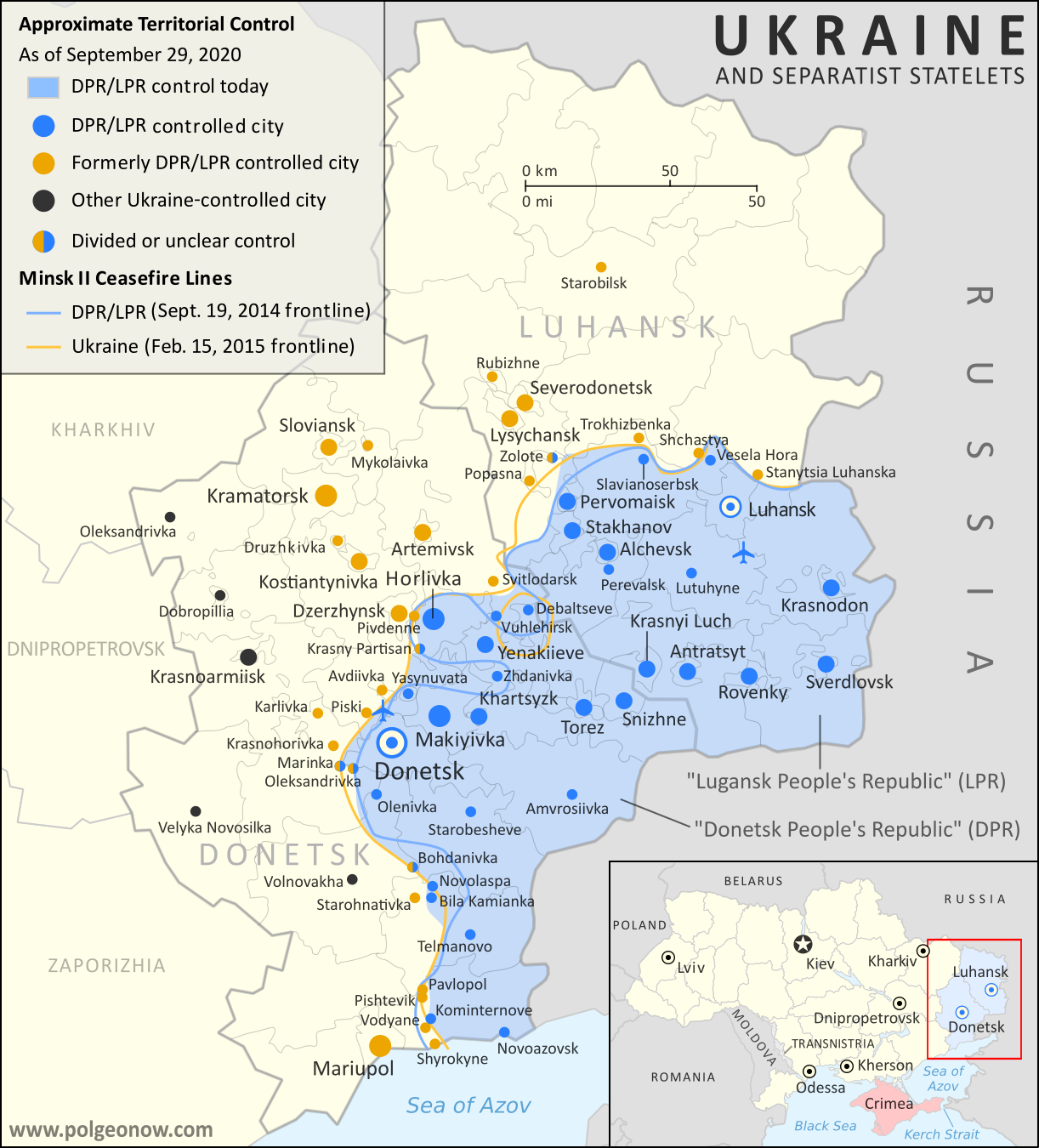
Map by Evan Centanni and Djordje Djukic. Contact us for permission to use this map.

(Subscribers click here to view this article in the member area)

Timeline by Djordje Djukic, with additional reporting by Evan Centanni

Donbass Frontline Map

In the four years since PolGeoNow last updated our Ukraine control map, little has changed in terms of territorial boundaries in the region of eastern Europe known as the Donbass. Forces of the Russia-backed self-proclaimed Donetsk People's Republic (DPR) and Lugansk People's Republic (LPR) still hold a large chunk of what most of the world considers Ukraine, though their plans of formally uniting into a confederation of "Novorossiya" ("New Russia") have long gone by the wayside. But as attempts at resolving the conflict peacefully grind slowly forward, fighting has continued at a low level along the frontlines, and we have made some small changes to the map where the situation has either changed or been clarified since 2016.

Wednesday, September 23, 2020

Map & Analysis: Which Countries Recognize Kosovo in 2020?

Announcing the re-launch of our Kosovo recognition updates series! PolGeoNow will now once again be providing timely reports on when countries recognize - or un-recognize - the disputed Republic of Kosovo.

Map of Kosovo recognition, indicating which states (countries) still recognize Kosovo's independence, which have withdrawn recognition, and which claims of recognition have been denied, as of September 2020, including new addition Israel. Colorblind accessible.
Click to enlarge. By Evan Centanni, modified from public domain blank world map.
Contact us for permission to use this map.

Friday, August 28, 2020

Yemen Control Map & Report: Al Qaeda / IS Enclave Eliminated - August 2020 (Subscription)

SUBSCRIBERS CLICK HERE TO PROCEED TO ARTICLE AND MAP

There are newer versions of this map available. To see them, view all Yemen articles on PolGeoNow.

Timeline by Djordje Djukic. Map by Evan Centanni, Djordje Djukic, and onestopmap.com

Map of what's happening in Yemen as of August 2020, including territorial control for the unrecognized Houthi government, president-in-exile Hadi and his allies in the Saudi-led coalition, the UAE-backed southern separatist Southern Transitional Council (STC), and Al Qaeda in the Arabian Peninsula (AQAP). Includes recent locations of fighting and other events, including Yakla, Qaniya, Damt, and more.
Subscribe for full access to all conflict map reports!

Over the past month, Yemen's Houthi government has continued slowly gaining ground, both against the internationally-recognized Hadi government and against Al Qaeda and "Islamic State" (ISIS/ISIL) forces.

See all this and more on the newest update to PolGeoNow's Yemen territorial control map, which includes a timeline of changes and important events since our previous Yemen map report in July.

This map and report are premium content available to paid subscribers of the PolGeoNow Conflict Mapping Service.

Want to see before you buy? Check out our most recent FREE SAMPLE Yemen map report!

Exclusive report includes:
  • Up-to-date map of current territorial control in Yemen, color-coded for the pro-Hadi coalition, the separatist Southern Transitional Council (STC), Houthi forces, and Al Qaeda in the Arabian Peninsula (AQAP)
  • Detailed indication of town-by-town control, including provincial boundaries, all major cities, and many smaller ones
  • Markers for recent areas of fighting, including Yakla, Qaniya, Damt, and more
  • Timeline of changes to the situation since July 25, 2020, with links to sources 

SUBSCRIBERS CLICK HERE TO PROCEED TO ARTICLE AND MAP

Not a member yet? Click here to learn more about our professional subscription service!

Can I purchase just this map?
This map and report are not available for automated purchase to non-subscribers. If you need access or republication rights for only this map report, contact service@polgeonow.com for options.

Saturday, August 22, 2020

Iraq Control Map & Timeline: Turkey Expands Control in North - August 2020 (Subscription)

SUBSCRIBERS CLICK HERE TO PROCEED TO ARTICLE AND MAP

(To see other maps in this series, view all Iraq articles.)

Research by Djordje Djukic. Map by onestopmap.com, Evan Centanni, and Djordje Djukic

Subscribe for full access to all conflict map reports!

Iraq Control Map 2020, updated to August 21. Shows areas of Iraq under Turkey's military contro, ISIS control (Islamic State/ISIL/Daesh), and under the control of the Baghdad government, the Kurdistan Peshmerga, and the Yezidi Sinjar Alliance (YBS and YJE). Marks Khamtir and Halukah Mountains (Jabal Khamtir and Jabal Halukah), controlled by Turkish forces. Colorblind accessible.
While Iraq's lines of control have mostly stayed the same since the beginning of the year, Turkey's military has been gradually increasing its control of the north. The incursion is part of the Turkish war against the Kurdish PKK, a rebel group from Turkey that now bases itself across the border in Iraq.

See all this and more on the latest update to PolGeoNow's concise, professional map of control in Iraq, including a timeline of changes since our previous Iraq map report of January 2020.

This map and report are premium content, available to paid subscribers of the PolGeoNow Conflict Mapping Service.

Want to see before you subscribe? Check out our most recent FREE SAMPLE Iraq map report!

Exclusive report includes:
  • Up-to-date map of current territorial control in Iraq, color-coded for the Iraqi government, "Islamic State" (ISIS/ISIL) fighters, Kurdistan's Peshmerga forces, and Yezidi militias. Colorblind accessible.
  • NEW: Turkish military control along the northern border, including key sites Mt. Khamtir (Jabal Khamtir) and Mt. Halukah (Jabal Halukah).
  • Detailed indication of town-by-town control, including all major cities and many smaller ones, as well as terrain, major roads, and provincial boundaries
  • Timeline of changes to the situation and related events since January, compiled by our Iraq-Syria specialist, with links to sources.
SUBSCRIBERS CLICK HERE TO PROCEED TO ARTICLE AND MAP

Not signed up yet? Click here to learn more about our professional subscription service!

Can I purchase just this map?
This map and report are not available for automated purchase to non-subscribers. If you need access or republication rights for only this map report, contact service@polgeonow.com for options.

Thursday, August 20, 2020

African Union Map Update: Mali & South Sudan Suspended, Sudan Reinstated

African Union: Map of Africa showing which countries are in the African Union in 2020, including active and suspended member countries and non-member territories. Updated for the September 2019 reinstatement of Sudan, the June 2020 suspension of South Sudan, and the August 2020 suspension of Mali (colorblind accessible).
Map by Evan Centanni, from blank map by Eric Gaba. License: CC BY-SA

Mali Suspended from African Union

The African Union (AU) suspended Mali from membership in the continental organization yesterday, after army mutineers marched to country's capital and overthrew the president. Major protests had been calling for the president's resignation for months, but his removal by force has not gone over well with the international community. In addition to the AU, Mali has also been suspended from the Economic Community of West African States (ECOWAS), an important group including most of Mali's neighboring countries.