 |
| Click to enlarge. By Evan Centanni, modified from public domain blank world map. Contact us for permission to use this map. |
Updates on the world's countries and borders
Monday, September 23, 2019
Taiwan Loses "Recognition" from Two Pacific Allies (Map)
You can always find the latest version of this map, and a list of all related articles, on our Which Countries "Recognize" Taiwan? page.
Map: Which Countries "Recognize" Taiwan in 2019?
This map and explainer will be updated whenever there's a change to the list of Taiwan's "diplomatic allies". You can find articles on each change by scrolling to the bottom of this page, or by viewing all Taiwan articles on PolGeoNow.
|
| Click to enlarge. By Evan Centanni, modified from public domain blank world map. Contact us for permission to use this map. |
Is Taiwan a Country?
At PolGeoNow we frequently report on self-proclaimed, unrecognized or partially-recognized countries - but Taiwan is a special case. It operates like an independent country today, but has never formally declared independence. Instead, Taiwan and its surrounding islands govern themselves as the "Republic of China" (ROC), under a constitution brought there by a former government of the Chinese mainland.Thursday, September 12, 2019
Syrian Civil War Map & Timeline - September 2019
There are newer versions of this map available. To see them, view all Syria updates.
(Subscribers click here to view this article in the member area)
Timeline by Djordje Djukic
 |
Base map by Koen Adams of onestopmap.com, with territorial control by Evan Centanni and Djordje Djukic.
Contact us for permission to use this map. |
Timeline by Djordje Djukic
Government Captures Rebel Stronghold in Idlib
In what's been nearly a month since our previous Syria control map update, almost all major activities have been focused around the southern end of rebel-held Idlib province. For the first time, government forces have captured a major town on the rebel side of the of would-be buffer zone set up last year by Turkey and Russia. Meanwhile, possible changes loom in Syria's northeast, where Turkey is pushing the US to set up a "safe zone" to keep the Kurdish-majority YPG militia away from the border.Thursday, September 5, 2019
Map: Indonesia Makes Plans to Move Capital
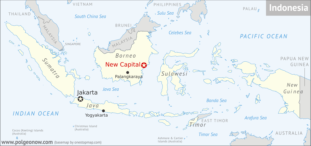 |
(Based on blank map by Wikipedia user Indon. License: CC BY-SA) |
A PolGeoNow News Brief
Here at Political Geography Now, we prioritize reporting on things in the world that have actually changed. But sometimes news about future or possible changes, like Belize and Guatemala going to court over their border dispute, are interesting enough that we want to share them with you sooner. This article represents a new format where we'll be publishing short, to-the-point summaries of those kinds of geography news stories. As always, we encourage you to tell us what you think by leaving a comment on our Twitter or Facebook!Saturday, August 31, 2019
Yemen Control Map & Report: Separatists Seize South - August 2019 (Subscription)
SUBSCRIBERS CLICK HERE TO PROCEED TO ARTICLE AND MAP
There are newer versions of this map available. To see them, view all Yemen articles on PolGeoNow.

Timeline by Djordje Djukic. Map by Evan Centanni, Djordje Djukic, and onestopmap.com
In recent weeks, a major new front has broken out in Yemen's civil war, as southern separatists have broken ranks with the Saudi-backed government of President Hadi, seizing control of key areas in the country's south.
See all this and more on the newest update to PolGeoNow's Yemen territorial control map, which includes a timeline of changes and important events since our previous Yemen map report in June. This report also includes a BONUS MAP showing the height of southern separatist control earlier in August.
This map and report are premium content available to paid subscribers of the PolGeoNow Conflict Mapping Service.
Want to see before you buy? Check out our most recent FREE SAMPLE Yemen map report!
Exclusive report includes:
SUBSCRIBERS CLICK HERE TO PROCEED TO ARTICLE AND MAP
Not a member yet? Click here to learn more about our professional subscription service!
Can I purchase just this map?
This map and report are not available for automated purchase to non-subscribers. If you need access or republication rights for only this map report, contact service@polgeonow.com for options.
There are newer versions of this map available. To see them, view all Yemen articles on PolGeoNow.
In recent weeks, a major new front has broken out in Yemen's civil war, as southern separatists have broken ranks with the Saudi-backed government of President Hadi, seizing control of key areas in the country's south.
See all this and more on the newest update to PolGeoNow's Yemen territorial control map, which includes a timeline of changes and important events since our previous Yemen map report in June. This report also includes a BONUS MAP showing the height of southern separatist control earlier in August.
This map and report are premium content available to paid subscribers of the PolGeoNow Conflict Mapping Service.
Want to see before you buy? Check out our most recent FREE SAMPLE Yemen map report!
Exclusive report includes:
- Up-to-date map of current territorial control in Yemen, color-coded for the pro-Hadi coalition, the separatist Southern Transitional Council (STC), Houthi forces, and Al Qaeda in the Arabian Peninsula (AQAP).
- Detailed indication of town-by-town control, including provincial boundaries, all major cities, and many smaller ones
- Markers for recent areas of fighting, including Shuqra, Ataq, Balhaf, Ketaf, and more
- Timeline of changes to the situation since June 15, 2019, with links to sources
- BONUS MAP showing the height of southern separatist control earlier in August
SUBSCRIBERS CLICK HERE TO PROCEED TO ARTICLE AND MAP
Not a member yet? Click here to learn more about our professional subscription service!
Can I purchase just this map?
This map and report are not available for automated purchase to non-subscribers. If you need access or republication rights for only this map report, contact service@polgeonow.com for options.
Subscribe to:
Posts (Atom)