 | |
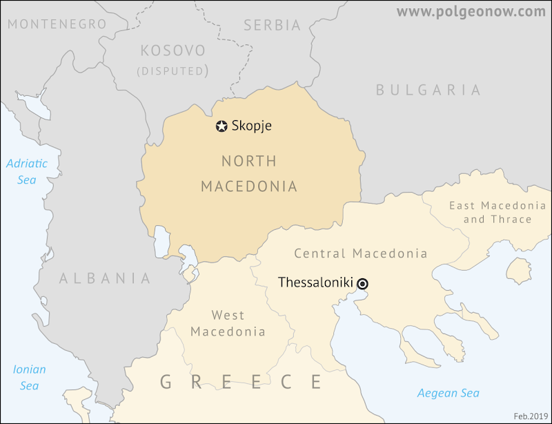
| North Macedonia is "north" because most of historical Macedonia was south of it, in what's now Greece. (Contact us for permission to use this map.) |
Updates on the world's countries and borders
Monday, February 18, 2019
"North Macedonia" Name Change Goes Into Effect
Monday, January 28, 2019
Syrian Civil War Map & Timeline: January 2019 (Subscription)
SUBSCRIBERS CLICK HERE TO PROCEED TO ARTICLE AND MAP
There are newer versions of this map available. To see them, view all Syria updates.
Research by Djordje Djukic. Map by onestopmap.com, Evan Centanni, and Djordje Djukic
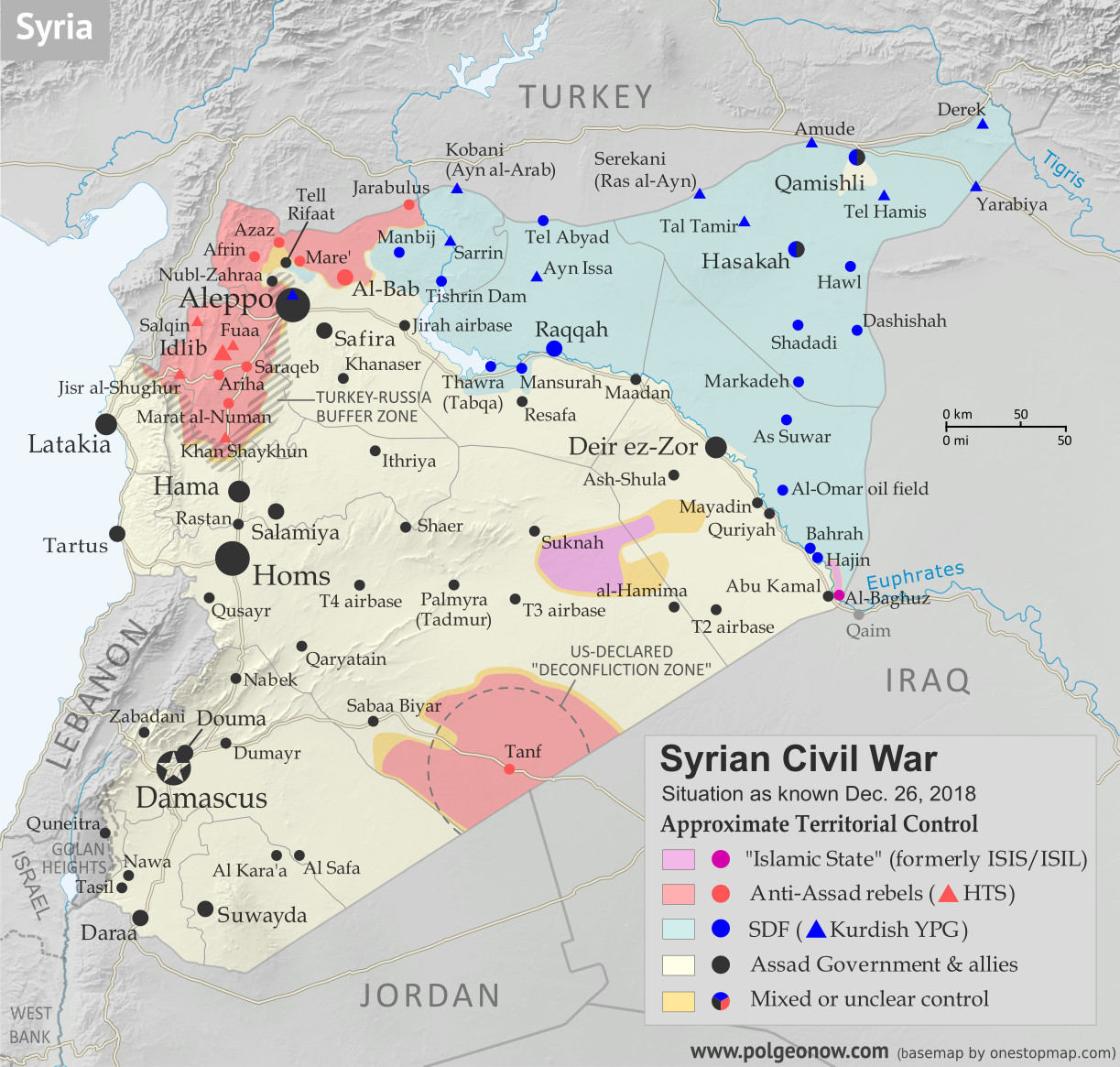
 Over the past month, the so-called "Islamic State" (ISIS/ISIL) in Syria has been reduced to just a single village and some remote desert areas, while the country's north braces for a new phase of the war after US withdrawal.
See all this and more on the latest update to PolGeoNow's concise, professional Syrian Civil War control map, which includes a timeline of changes since our previous Syria map report in December, with sources cited.
This map and report are premium content, available to paid subscribers of the PolGeoNow Conflict Mapping Service.
Want to see before you subscribe? Check out our most recent FREE SAMPLE Syria map!
Exclusive map report includes:
SUBSCRIBERS CLICK HERE TO PROCEED TO ARTICLE AND MAP
Not signed up yet? Click here to learn more about our professional subscription service!
Can I purchase just this map?
This map and report are not available for automated purchase to non-subscribers. If you need access or republication rights for only this map report, contact service@polgeonow.com for options.
There are newer versions of this map available. To see them, view all Syria updates.
Research by Djordje Djukic. Map by onestopmap.com, Evan Centanni, and Djordje Djukic
Over the past month, the so-called "Islamic State" (ISIS/ISIL) in Syria has been reduced to just a single village and some remote desert areas, while the country's north braces for a new phase of the war after US withdrawal.See all this and more on the latest update to PolGeoNow's concise, professional Syrian Civil War control map, which includes a timeline of changes since our previous Syria map report in December, with sources cited.
This map and report are premium content, available to paid subscribers of the PolGeoNow Conflict Mapping Service.
Want to see before you subscribe? Check out our most recent FREE SAMPLE Syria map!
Exclusive map report includes:
- Up-to-date illustration of current territorial control in Syria, color-coded for the Assad government, rebel groups, "Islamic State" (ISIS/ISIL) fighters, and the Kurdish-led Syrian Democratic Forces (SDF). Colorblind accessible.
- Location of the demilitarized buffer zone sponsored by Turkey and Russia
- Outline showing the approximate location of the one publicly-known US "deconfliction zone"
- Special symbols indicating towns dominated by rebels of the former Al Qaeda Nusra Front (now Hayat Tahrir al-Sham or HTS) and by the Kurdish YPG militia (part of the US-backed SDF).
- Detailed indication of city-by-city control, including key towns and other locations important to current events.
- Locations of recent control changes and other important events, including Baghuz, Murashidah, Saraqeb, Arima and more.
- Detailed timeline of important events and changes to territorial control since December 26, 2018, compiled by our Syria-Iraq expert, with links to sources.
SUBSCRIBERS CLICK HERE TO PROCEED TO ARTICLE AND MAP
Not signed up yet? Click here to learn more about our professional subscription service!
Can I purchase just this map?
This map and report are not available for automated purchase to non-subscribers. If you need access or republication rights for only this map report, contact service@polgeonow.com for options.
Sunday, December 30, 2018
All About South Ossetia's 2017 Name Change
 |
| South Ossetia (purple) and Abkhazia (green) within the claimed borders of Georgia. Click to enlarge. Map by ChrisO based on UN map of Georgia (public domain; source). |
Adding "State of Alania"
At PolGeoNow we promise to inform our readers any time one of the world's countries changes its name, even if it's just a modification to the country's official long name, or a switch in the name's preferred English translation.But there was one name change we missed out on reporting last year - depending on what you consider a "country".
In April 2017, people in the disputed Republic of South Ossetia voted to change the self-declared country's full name to "The Republic of South Ossetia – the State of Alania". The name change referendum reportedly passed with about 80% of valid votes in favor, though many countries strongly condemned the whole process, seeing it as part of an ongoing Russia-led attempt to steal the region away from Georgia (the country, not the US state).
Map: Which Countries Recognized Abkhazia and South Ossetia in 2018?
This is our new, completely redesigned map of which countries consider disputed South Ossetia and Abkhazia to be independent from Georgia. From now on, PolGeoNow will report on any changes to Abkhazian or South Ossetian recognition with updates to this map.
 |
| Click to enlarge. By Evan Centanni, modified from public domain blank world map. Contact us for permission to use this map. |
Friday, December 28, 2018
Syrian Civil War Map & Timeline: IS Loses Western Enclave - December 2018
There are newer versions of this map available. To see them, view all Syria updates.
(Subscribers click here to view this article on the member site)
Timeline by Djordje Djukic
 |
Base map by Koen Adams of onestopmap.com, with territorial control by Evan Centanni and Djordje Djukic.
Contact us for permission to use this map. |
Timeline by Djordje Djukic
Syria: Where Things Stand Now
In the month and a half since our previous Syria control map report, the main territorial changes have been losses by the so-called "Islamic State" (IS; formerly ISIS/ISIL). The Assad government has eliminated the last pocket of IS control in western Syria, in the south's Al Safa area, and the Kurdish-led Syrian Democratic Forces (SDF) have recaptured the town of Hajin in the east, while also driving IS once again off of the Syria-Iraq border.
Subscribe to:
Posts (Atom)