 |
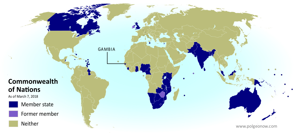
| Map by Evan Centanni, modified from public domain graphic. Visit our Commonwealth of Nations page to check for newer versions, or contact us for permission to use this map. |
Updates on the world's countries and borders
Wednesday, March 7, 2018
Gambia Rejoins the Commonwealth (Map)
What Are the Commonwealth Countries? Map of the Commonwealth of Nations
This map and explainer will be updated whenever there's a change in Commonwealth membership, including suspensions and reinstatements. You can find articles on each change by scrolling to the bottom of this page, or by viewing all Commonwealth articles on PolGeoNow.
(Subscribers click here to view this article in the members area.)
 |
| Map by Evan Centanni, modified from public domain graphic. Contact us for permission to use this map. |
What is the Commonwealth of Nations?
The Commonwealth of Nations - formerly the "British Commonwealth", but now usually just called "the Commonwealth" - is a loose association of countries that grew out of the British Empire as its colonies transitioned into independent countries during the 20th Century. It more or less took its modern form in 1949, but its history goes back at least to 1926, when the most Westernized colonies of the British Empire were transitioning towards independence. It's mostly a casual forum for cooperation between countries that used to be British colonies or dependencies (though some other countries have joined), and it has a charter promoting values like world peace, democracy, and human rights.Saturday, February 24, 2018
Iraq Control Map & Timeline - February 2018 (Subscription)
SUBSCRIBERS CLICK HERE TO PROCEED TO ARTICLE AND MAP
There are newer versions of this map available. To see them, view all Iraq updates.
Research by Djordje Djukic. Map by onestopmap.com, Evan Centanni, and Djordje Djukic

Since November, pro-government forces in Iraq have nearly, but not entirely, cleared the country of control by the so-called "Islamic State" (ISIS/ISIL), with the group still reportedly holding out in parts of the western desert.
See all this and more on the latest update to PolGeoNow's concise, professional map of control in Iraq's civil war, including a timeline of changes since our previous Iraq map report of November 2017.
This map and report are premium content, available to paid subscribers of the PolGeoNow Conflict Mapping Service.
Want to see before you subscribe? Check out our most recent FREE SAMPLE Iraq map report!
Exclusive report includes:
Not signed up yet? Click here to learn more about our professional subscription service!
Can I purchase just this map?
This map and report are not available for automated purchase to non-subscribers. If you need access or republication rights for only this map report, contact service@polgeonow.com for options.
There are newer versions of this map available. To see them, view all Iraq updates.
Research by Djordje Djukic. Map by onestopmap.com, Evan Centanni, and Djordje Djukic
Since November, pro-government forces in Iraq have nearly, but not entirely, cleared the country of control by the so-called "Islamic State" (ISIS/ISIL), with the group still reportedly holding out in parts of the western desert.
See all this and more on the latest update to PolGeoNow's concise, professional map of control in Iraq's civil war, including a timeline of changes since our previous Iraq map report of November 2017.
This map and report are premium content, available to paid subscribers of the PolGeoNow Conflict Mapping Service.
Want to see before you subscribe? Check out our most recent FREE SAMPLE Iraq map report!
Exclusive report includes:
- Up-to-date map of current territorial control in Iraq, color-coded for the Iraqi government, "Islamic State" (ISIS/ISIL) fighters, Kurdistan's Peshmerga forces, and Yezidi militias. Colorblind accessible.
- Detailed indication of town-by-town control, including all major cities and many smaller ones, as well as terrain, major roads, and provincial boundaries
- Timeline of changes to the situation since the end of November, compiled by our Iraq-Syria specialist, with links to sources.
Not signed up yet? Click here to learn more about our professional subscription service!
Can I purchase just this map?
This map and report are not available for automated purchase to non-subscribers. If you need access or republication rights for only this map report, contact service@polgeonow.com for options.
Thursday, February 15, 2018
Syrian Civil War Map & Timeline - February 2018
There are newer versions of this map available. To see them, view all Syria updates.
(Subscribers click here to view this article on the member site)
Timeline by Djordje Djukic
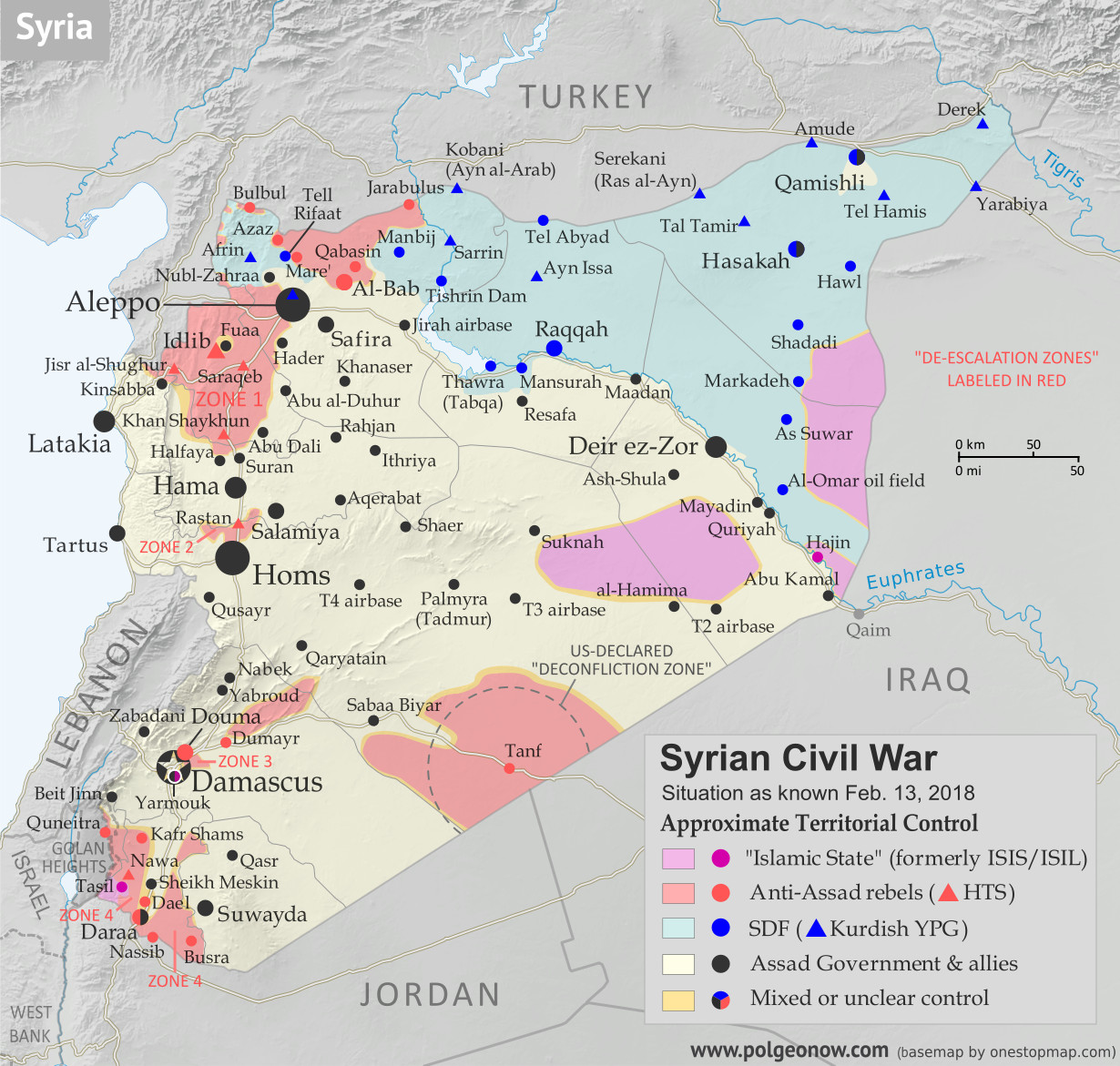 |
Base map by Koen Adams of onestopmap.com, with territorial control by Evan Centanni and Djordje Djukic.
Contact us for permission to use this map. |
Timeline by Djordje Djukic
Situation Summary
The past few weeks since our previous Syria map update have been dominated by news from two main arenas of battle, both in the country's northwest. In the most politically significant development, the Turkish military has entered the Kurdish-administrated Afrin region (also spelled "Efrin") as part of a mission, alongside allied rebel fighters, to drive Kurdish militias out of the western border region. Meanwhile, forces loyal to Syria's Assad government have made major advances in areas south of Aleppo, eliminating an enclave of the so-called "Islamic State" (IS; formerly ISIS/ISIL) and cutting into rebel control around the edges of Idlib province.Thursday, February 8, 2018
Parade of Nations: Which Countries Are (and Aren't) in the Olympics? (PyeongChang 2018)
This is an older version of our Parade of Nations article. Click here to see the newest edition!
This is an updated version of an article first published in 2012. You can also read the London 2012, Sochi 2014, and Rio 2016 versions.
 |
| Map of all countries in the Olympics and their regional associations. By Evan Centanni, modeled after this map. |
The 2018 Winter Olympics in Pyeongchang County, South Korea officially open tomorrow, February 9th! They'll be the second Olympics to be hosted in South Korea, after the 1988 Summer Games. These are also only the third-ever Winter Olympics to be held outside of Europe and North America, following up the 1972 and 1998 games hosted by Japan.
Of course, it wouldn't be an Olympic opening ceremony without the Parade of Nations. But how many countries are there in the games, and is everyone included? Read on for PolGeoNow's updated guide to the roster of Olympic Nations...
Subscribe to:
Posts (Atom)