Thursday, February 15, 2018

Syrian Civil War Map & Timeline - February 2018

There are newer versions of this map available. To see them, view all Syria updates.

Who controls what in Syria? Rebel and ISIS control map of the Syrian Civil War. Shows territorial control as of February 2018 (Free Syrian Army rebels, Kurdish YPG, Syrian Democratic Forces (SDF), Jabhat Fateh al-Sham / Hayat Tahrir al-Sham (Al-Nusra Front), Islamic State (ISIS/ISIL), and others). Includes Russia-Turkey-Iran agreed de-escalation zones and US deconfliction zone, plus recent locations of conflict and territorial control changes, such as Abu al-Duhur, Bulbul, Saraqeb, and more. Colorblind accessible.
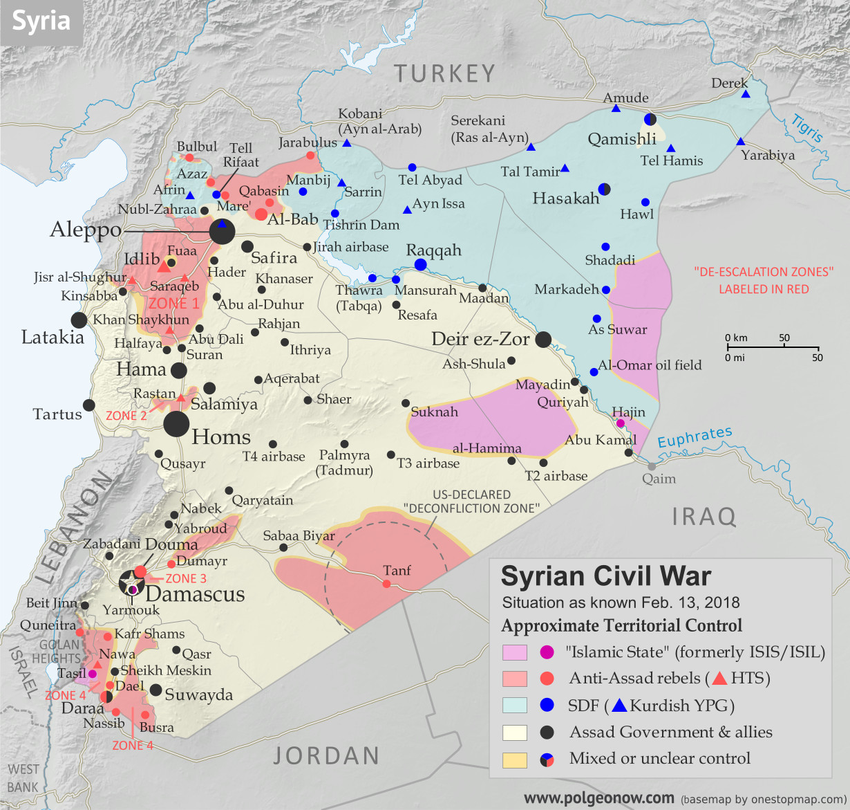
Base map by Koen Adams of onestopmap.com, with territorial control by Evan Centanni and Djordje Djukic.
Contact us for permission to use this map.
(Subscribers click here to view this article on the member site)

Timeline by Djordje Djukic

Situation Summary

The past few weeks since our previous Syria map update have been dominated by news from two main arenas of battle, both in the country's northwest. In the most politically significant development, the Turkish military has entered the Kurdish-administrated Afrin region (also spelled "Efrin") as part of a mission, alongside allied rebel fighters, to drive Kurdish militias out of the western border region. Meanwhile, forces loyal to Syria's Assad government have made major advances in areas south of Aleppo, eliminating an enclave of the so-called "Islamic State" (IS; formerly ISIS/ISIL) and cutting into rebel control around the edges of Idlib province.

Thursday, February 8, 2018

Parade of Nations: Which Countries Are (and Aren't) in the Olympics? (PyeongChang 2018)

This is an older version of our Parade of Nations article. Click here to see the newest edition!

This is an updated version of an article first published in 2012. You can also read the London 2012, Sochi 2014, and Rio 2016 versions.

World map showing the five continental associations of National Olympic Committees, including all nations eligible for the PyeongChang 2018 Olympic Games.
Map of all countries in the Olympics and their regional associations. By Evan Centanni, modeled after this map.

The 2018 Winter Olympics in Pyeongchang County, South Korea officially open tomorrow, February 9th! They'll be the second Olympics to be hosted in South Korea, after the 1988 Summer Games. These are also only the third-ever Winter Olympics to be held outside of Europe and North America, following up the 1972 and 1998 games hosted by Japan.

Of course, it wouldn't be an Olympic opening ceremony without the Parade of Nations. But how many countries are there in the games, and is everyone included? Read on for PolGeoNow's updated guide to the roster of Olympic Nations...

Saturday, February 3, 2018

Map: Costa Rica & Nicaragua Settle Border Dispute in Court

Conflicto Isla Portillos - mapa 2018. Map of Costa Rica and Nicaragua's post-2015 territorial dispute on Isla Portillos at the mouth of Rio San Juan, showing the judgment of the International Court of Justice (ICJ) of February 2018, based on the case filed in 2017. Includes key features such as Harbor Head Lagoon, the Nicaraguan military camp, the disputed territory along the beach, and the small water channels used to argue Nicaragua's case. Colorblind accessible.
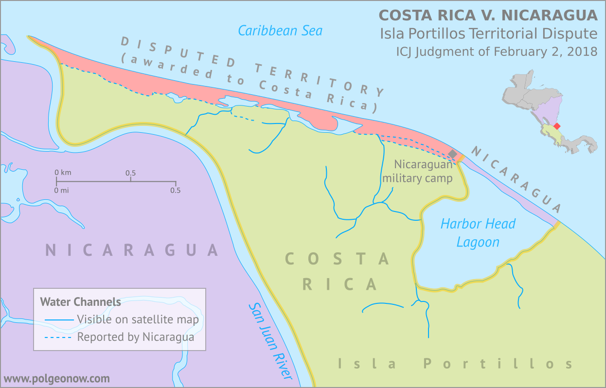
Map by Evan Centanni, based on materials submitted to the court. Contact for usage permissions.

World Court Rules on Costa Rica vs. Nicaragua

What happens when two countries draw their border along a river, then the river changes course? The world got to find out yesterday, as the UN's International Court of Justice (ICJ) released its judgement on a border dispute between Nicaragua and Costa Rica. Though the court's ruling was dominated by a related request to define the two countries' borders at sea, it also involved a tiny sliver of land in a temperamental river delta.

Tuesday, January 30, 2018

All About Nagorno-Karabakh's 2017 Name Change

Map of the self declared Republic of Artsakh (Nagorno-Karabakh Republic) in relation to Armenia and Azerbaijan. Includes capital cities Yerevan, Baku, and Stepanakert.
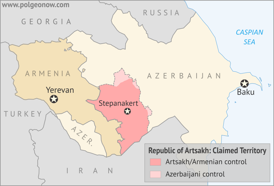
Map by Evan Centanni, modified from this map by Bourrichon and Lesqual. License: CC BY-SA

Nagorno-Karabakh is Now "Artsakh"

Most country name changes are just modifications to the country's official long name, or a switch in the name's preferred English translation. But last year, one self-proclaimed country changed its title completely.

In February 2017, the disputed Nagorno-Karabakh Republic officially became the "Republic of Artsakh". The name switch was part of a new constitution, approved in an internationally-controversial Feb. 20 referendum. According to the breakaway government's official figures, the referendum passed by 88%, with a voter turnout of 76%.

Sunday, January 21, 2018

Syrian Civil War Map & Timeline: Rebels Lose Major Ground - January 2018 (Subscription)

SUBSCRIBERS CLICK HERE TO PROCEED TO ARTICLE AND MAP

There are newer versions of this map available. To see them, view all Syria updates.

Research by Djordje Djukic. Map by onestopmap.com, Evan Centanni, and Djordje Djukic

Subscribe for full access to all conflict map reports!

Map of Syrian Civil War (Syria control map): Fighting and territorial control in Syria in January 2018 (Free Syrian Army rebels, Kurdish YPG, Syrian Democratic Forces (SDF), Jabhat Fateh al-Sham / Hayat Tahrir al-Sham (Al-Nusra Front), Islamic State (ISIS/ISIL), and others). Includes Russia-Turkey-Iran agreed de-escalation zones and US deconfliction zone, plus recent locations of conflict and territorial control changes, such as Abu al-Duhur, Beit Jinn, Rahjan, and more. Colorblind accessible.
The past month has seen major losses for hardline rebels in Syria's northwest, excluded from the de-escalation agreements, even as the push against the so-called "Islamic State" (ISIS/ISIL) has slowed in the east.

See all this and more on the latest update to PolGeoNow's concise, professional Syrian Civil War control map, which includes a timeline of changes since our previous Syria map report in November, with sources cited.

This map and report are premium content, available to paid subscribers of the PolGeoNow Conflict Mapping Service.

Want to see before you subscribe? Check out our most recent FREE SAMPLE Syria map!

Exclusive map report includes:
  • Up-to-date illustration of current territorial control in Syria, color-coded for the Assad government, rebel groups, "Islamic State" (ISIS/ISIL) fighters, and Kurdish/SDF forces. Colorblind accessible.
  • Markers showing the approximate locations of Russian-Turkish-Iranian "de-escalation zones" and the one known US "deconfliction zone".
  • Special symbols indicating towns dominated by rebels of the former Al Qaeda Nusra Front (now Hayat Tahrir al-Sham) and US-backed Syrian Democratic Forces (SDF).
  • Detailed indication of city-by-city control, including key towns and other locations important to current events.
  • Locations of recent fighting and other important events, including Abu al-Duhur, Beit Jinn, Rahjan, and more.
  • Detailed timeline of important events and changes to territorial control since December 13, 2017, compiled by our Syria-Iraq expert, with links to sources.

SUBSCRIBERS CLICK HERE TO PROCEED TO ARTICLE AND MAP

Not signed up yet? Click here to learn more about our professional subscription service!

Can I purchase just this map?
This map and report are not available for automated purchase to non-subscribers. If you need access or republication rights for only this map report, contact service@polgeonow.com for options.