 |
| Click to enlarge. By Evan Centanni, modified from public domain blank world map. |
Updates on the world's countries and borders
Thursday, June 15, 2017
Panama Recognizes China, Stops Recognizing Taiwan (Map)
There are newer versions of this map available. You can always find the latest version, and a list of all related articles, on our Which Countries Recognize Taiwan? page.
Wednesday, June 14, 2017
How Many Countries Are There in the World in 2017?
There are newer editions of this article available. To find the most recent, view all "How Many Countries in the World" updates!
This article, originally from 2011, has been revised and updated to June 2017.
One of the most basic questions for map-lovers is, "How many countries are there in the world?" But anyone who replies with just a number is leaving out part of the story. It actually depends a lot on how you define a "country".
Here are six of the most common answers, each correct in its own way:
This article, originally from 2011, has been revised and updated to June 2017.
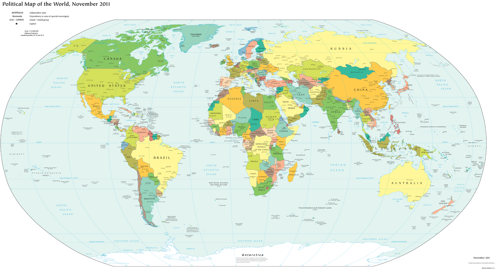 |
| A world political map published by the US government (public domain) |
Here are six of the most common answers, each correct in its own way:
Saturday, June 10, 2017
Libya Control Map & Timeline - June 2017 (Subscription)
SUBSCRIBERS CLICK HERE TO PROCEED TO ARTICLE AND MAP
There are newer versions of this map available. To see them, view all Libya updates.
Research by Djordje Djukic. Map by onestopmap.com, Evan Centanni, and Djordje Djukic.
 The past month has seen major changes to control in Libya's interior, as rival governments face off there and in around the capital city of Tripoli. Meanwhile, the so-called "Islamic State" (ISIS/ISIL)
has reportedly re-emerged in rural areas near the coast.
The past month has seen major changes to control in Libya's interior, as rival governments face off there and in around the capital city of Tripoli. Meanwhile, the so-called "Islamic State" (ISIS/ISIL)
has reportedly re-emerged in rural areas near the coast.
See all this and more on the latest update to PolGeoNow's concise, professional Libyan Civil War control map, which comes with a timeline of changes since our April 2017 Libya control map report.
This map and report are premium content available to paid subscribers of the PolGeoNow Conflict Mapping Service.
Want to see before you subscribe? Check out our most recent FREE SAMPLE Libya map!
Exclusive report includes:
SUBSCRIBERS CLICK HERE TO PROCEED TO ARTICLE AND MAP
Not signed up yet? Click here to learn more about our professional subscription service!
Can I purchase just this map?
This map and report are not available for automated purchase to non-subscribers. If you need access or republication rights for only this map report, contact service@polgeonow.com for options.
There are newer versions of this map available. To see them, view all Libya updates.
Research by Djordje Djukic. Map by onestopmap.com, Evan Centanni, and Djordje Djukic.
The past month has seen major changes to control in Libya's interior, as rival governments face off there and in around the capital city of Tripoli. Meanwhile, the so-called "Islamic State" (ISIS/ISIL)
has reportedly re-emerged in rural areas near the coast.See all this and more on the latest update to PolGeoNow's concise, professional Libyan Civil War control map, which comes with a timeline of changes since our April 2017 Libya control map report.
This map and report are premium content available to paid subscribers of the PolGeoNow Conflict Mapping Service.
Want to see before you subscribe? Check out our most recent FREE SAMPLE Libya map!
Exclusive report includes:
- Up-to-date map of current territorial control in Libya, color-coded for the UN-backed Government of National Accord (GNA), the rival Tobruk parliament and Khalifa Haftar's Libyan National Army (LNA), and the so-called "Islamic State" (ISIS/ISIL). New colors have been added for the Tuareg and Toubou ethnic alliances that control much of the country's far south.
- Detailed indication of city-by-city control, including key towns and other locations important to current events.
- Locations of recent fighting and military operations, including Tamenhint and Jufra airbases, Brak, Sukna, Bani Walid, and more.
- Detailed timeline of important events and changes to territorial control since April 28, 2017, with links to all sources.
SUBSCRIBERS CLICK HERE TO PROCEED TO ARTICLE AND MAP
Not signed up yet? Click here to learn more about our professional subscription service!
Can I purchase just this map?
This map and report are not available for automated purchase to non-subscribers. If you need access or republication rights for only this map report, contact service@polgeonow.com for options.
Sunday, June 4, 2017
"Islamic State" in the Philippines? Detailed Control Map & Timeline of the Marawi Conflict
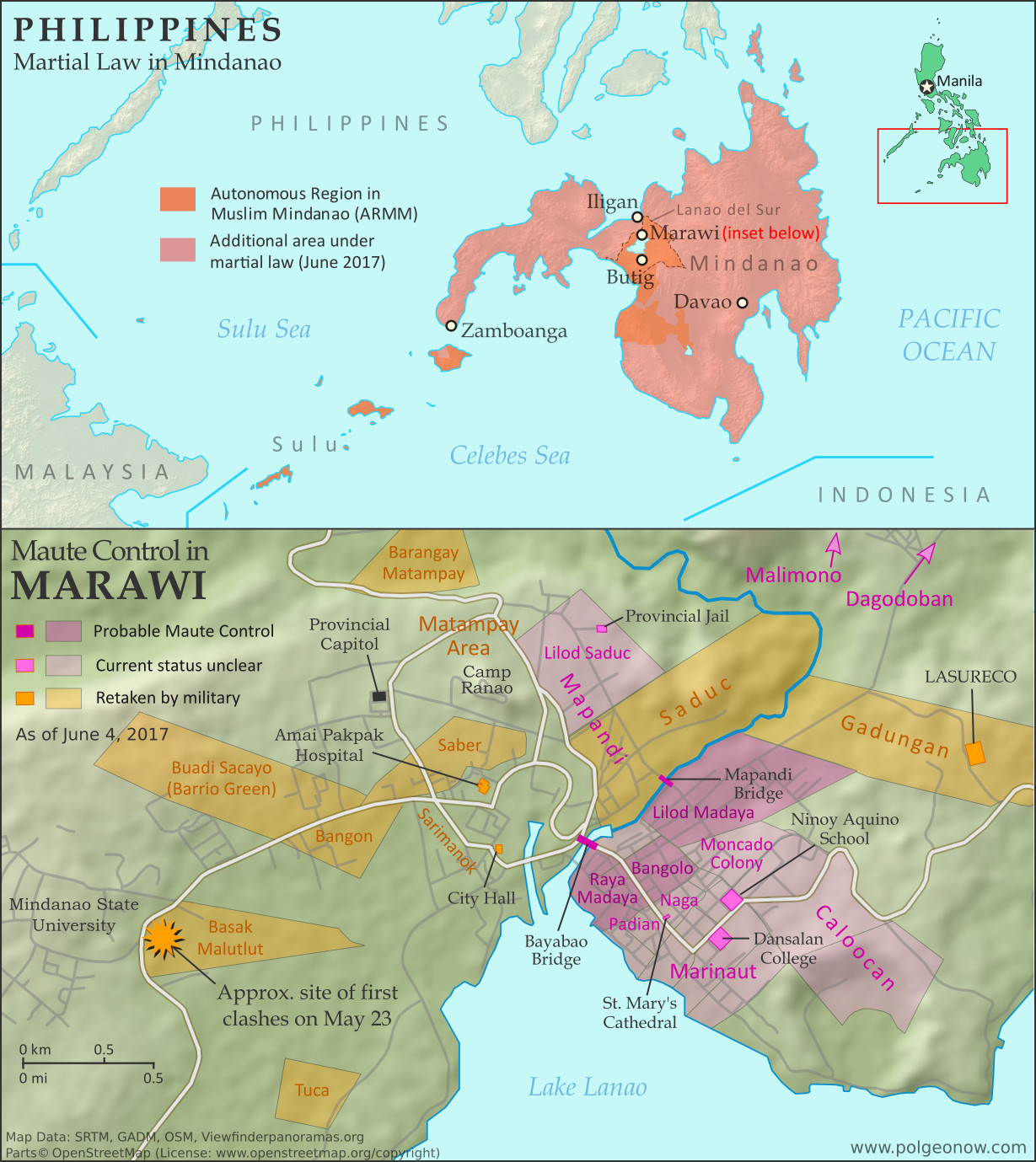 |
Map by Evan Centanni. All rights reserved.
|
Saturday, May 27, 2017
Syria Control Map & Timeline: "De-escalation zones" & Continued IS Losses - May 2017 (Subscription)
SUBSCRIBERS CLICK HERE TO PROCEED TO ARTICLE AND MAP
There are newer versions of this map available. To see them, view all Syria updates.
Research by Djordje Djukic. Map by onestopmap.com, Evan Centanni, and Djordje Djukic
 The past month has seen continued territorial losses for the so-called "Islamic State"
(IS; formerly, ISIS/ISIL), as government and rebel forces take vast swaths of desert and a Kurdish-led coalition closes in on the group's capital. Meanwhile, foreign countries have begun drawing up provisional ceasefire zones along hardened lines between rebel and government control.
The past month has seen continued territorial losses for the so-called "Islamic State"
(IS; formerly, ISIS/ISIL), as government and rebel forces take vast swaths of desert and a Kurdish-led coalition closes in on the group's capital. Meanwhile, foreign countries have begun drawing up provisional ceasefire zones along hardened lines between rebel and government control.
See all this and more on the latest update to PolGeoNow's concise, professional Syrian Civil War control map, which includes a timeline of changes since our previous Syria map report in April, with sources cited.
This map and report are premium professional content, available to paid subscribers of the PolGeoNow Conflict Mapping Service.
Want to see before you subscribe? Check out our most recent FREE SAMPLE Syria map!
Exclusive report includes:
SUBSCRIBERS CLICK HERE TO PROCEED TO ARTICLE AND MAP
Not signed up yet? Click here to learn more about our professional subscription service!
Can I purchase just this map?
This map and report are not available for automated purchase to non-subscribers. If you need access or republication rights for only this map report, contact service@polgeonow.com for options.
There are newer versions of this map available. To see them, view all Syria updates.
Research by Djordje Djukic. Map by onestopmap.com, Evan Centanni, and Djordje Djukic
The past month has seen continued territorial losses for the so-called "Islamic State"
(IS; formerly, ISIS/ISIL), as government and rebel forces take vast swaths of desert and a Kurdish-led coalition closes in on the group's capital. Meanwhile, foreign countries have begun drawing up provisional ceasefire zones along hardened lines between rebel and government control.See all this and more on the latest update to PolGeoNow's concise, professional Syrian Civil War control map, which includes a timeline of changes since our previous Syria map report in April, with sources cited.
This map and report are premium professional content, available to paid subscribers of the PolGeoNow Conflict Mapping Service.
Want to see before you subscribe? Check out our most recent FREE SAMPLE Syria map!
Exclusive report includes:
- Up-to-date map of current territorial control in Syria, color-coded for the Assad government, rebel groups, "Islamic State" (ISIS/ISIL) fighters, and Kurdish/SDF forces. Colorblind accessible.
- Markers showing the approximate locations of Russian-Turkish-Iranian "de-escalation zones" and the one known US "deconfliction zone".
- Special symbols indicating towns dominated by rebels of the former Nusra Front (now Hayat Tahrir al-Sham) and US-backed Syrian Democratic Forces (SDF).
- Detailed indication of city-by-city control, including key towns and other locations important to current events.
- Locations of recent fighting and other important events, including Qaboun, Sawwana, Shaer gas fields, Jirah airbase, and more.
- Detailed timeline of important events and changes to territorial control since April 26, 2017, compiled by our Syria-Iraq expert, with links to sources.
SUBSCRIBERS CLICK HERE TO PROCEED TO ARTICLE AND MAP
Not signed up yet? Click here to learn more about our professional subscription service!
Can I purchase just this map?
This map and report are not available for automated purchase to non-subscribers. If you need access or republication rights for only this map report, contact service@polgeonow.com for options.
Subscribe to:
Posts (Atom)