Monday, October 28, 2013

Announcement: The Future of PolGeoNow

Dear Readers,

Map of territory in the Philippines and Malaysia claimed by the Bangsamoro Republik, plus territorial control by the Moro National Liberation Front (MNFL) as part of the the Zamboanga crisis.
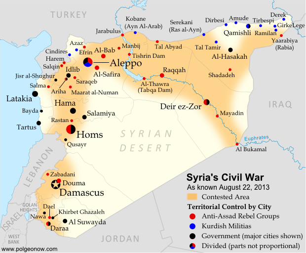
This map took 20 hours of work.
Two and a half years ago, I started Political Geography Now as a site for people who want to keep up with changes to the world political map. It's grown a great deal in both readership and coverage of world events since then. And as some of you know, it's been almost entirely a labor of love. Putting out new maps and reports requires hours of work every week, but has earned me almost zero money.

I'm happy that I can use my free time to create something cool. But after years of living paycheck-to-paycheck off part-time side jobs, the stress of creating almost-weekly new maps and articles has become too much to juggle. I'm busy all the time, but still struggling to pay my rent each month. If Political Geography Now is going to continue publishing its high-quality maps and articles, it needs to start generating some modest income.

I don't want end or scale back the blog any more than you do, so here's the plan: from next month PolGeoNow will continue to publish many free articles and maps on the site, but also start offering some paid premium content. If you can't afford to pay, I understand - you'll still get to enjoy regular updates and great maps, and the entire catalog of past articles will always be freely accessible. But if you are able to pay to support our work, you'll get access to even more original maps and in-depth, professional reporting. I hope to even expand coverage in some areas, for example by publishing more frequent updates to conflict zone maps.

Map of territorial control in Syria's civil war
Want more frequent Syria updates?
Though it may be possible to buy individual articles in the future, I'm starting off by offering paid subscriptions to access all premium content online. Besides all the great content, subscribing will also get you an ad-free interface and discounts on special services or products the site may provide in the future. If you're already sold, you can sign up now to lock in the introductory price!

Moving to even a partial paid model has been a very tough decision, and I hope you can all bear with us through the transition. I'm always happy to hear feedback from PolGeoNow readers, so feel free to let me know about any of your advice or concerns. Thank you so, so much for all your wonderful support so far!

All the best,

Evan Centanni
evan@polgeonow.com

New premium subscriptions: Sign Up Now!

Friday, October 25, 2013

No More Bangsamoro Republik: Philippine Rebel Occupation Defeated


Map of territory in the Philippines and Malaysia claimed by the Bangsamoro Republik, plus territorial control by the Moro National Liberation Front (MNFL) during last month's Zamboanga crisis.
Claims and territorial control of the MNLF rebels and Bangsamoro Republik during last month's crisis. Click to see full-sized map and article. Map by Evan Centanni.
Territory Retaken by Government
Last month, Political Geography Now mapped Moro rebel control in the Philippines' Zamboanga crisis. The rebels, drawn from a group which had declared independence from the Philippines as the Bangsamoro Republik, had occupied several neighborhoods of Zamboanga City in the country's southwest after an aborted attempt to raise their flag in the city center.

Ten days after we published that article, the government of the Philippines declared the crisis over, with all hostages freed and only scattered fighting occurring over the next two days as the surviving rebels attempted to escape the area. After nearly three weeks of chaos, the city of Zamboanga was once again fully under government control.

What of the MNLF fighters?
Though hundreds of rebels from the Moro National Liberation Front (MNLF) were killed in the fighting, some did escape, and the attack's commander Habier Malik is still missing. Nur Misuari, the faction's leader and founder of the self-declared Bangsamoro Republik, was not present at the attack but is now wanted on charges of rebellion. But he may have more than just the government to worry about - Malik's surviving men from the Zamboanga attack are also said to be on the hunt for Misuari, who allegedly tricked them into participating. According to Mujiv Hataman, governor of the officially sanctioned Autonomous Region in Muslim Mindanao (ARMM), Misuari promised Malik's men that U.N. peacekeepers would arrive soon after the attack to secure Bangsamoro independence and reward each fighter with 10,000 pesos (US $230) and a new weapon.

BIFF Attacks
Attacks by other Moro rebel groups in nearby regions continued until just after Zamboanga was secured. In particular, the Bangsamoro Islamic Freedom Fighters (BIFF), a splinter group from the Moro Islamic Liberation Fighters (MILF) who are currently in peace talks with the Philippine government, continued launching attacks elsewhere in Mindanao into early October. The BIFF is not closely tied to Nur Misuari's MNLF, and these were apparently just opportunistic attacks taking advantage of the military's distraction during the crisis in Zamboanga.

More information: Bangsamoro Republik? Philippine Separatists Seize Territory (map)

Thursday, October 17, 2013

Map Update: Kosovo Recognized by 3 More Countries (103/193)

Map of countries that recognize the Republic of Kosovo as an independent state, updated for October 2013 with most recent additions (Thailand, Libya, Granada) and disputed recognitions highlighted
Countries recognizing the Republic of Kosovo in green, highlighting recent additions. Disputed recognitions in yellow. Kosovo in magenta. Map by Evan Centanni, modified from public domain graphic (source).

Friday, September 27, 2013

Central African Republic: Towns Retaken by Government-allied Forces (September 2013)

There are newer maps of this conflict available. To see them, view all Central African Republic articles on PolGeoNow. 

Map of control in the Central African Republic's anti-Seleka counter-rebellion, including towns of Bouca and Bossangoa
Counter-rebels briefly captured at least one Central African Republic town in September (click for full map and article). Map by Evan Centanni from this map by Wikimedia user Keitsist. License: CC BY-SA
Territory Nominally Reunited
Two weeks ago, Political Geography Now reported on rebel control in the Central African Republic's new counter-rebellion. Since then, the towns of Bouca and Bossangoa have reportedly both been recaptured by forces belonging to Séléka, the former rebel coalition whose leader is now the president of the Central African Republic.

However, as outrage grows over vicious violence against civilians which has continued since Séléka's campaign to take over the Central African Republic earlier this year, the new President Michel Djotodia has little actual control over the country.

One another analyst says that "law and order stops outside the presidential palace" in Bangui, and the AFP reported earlier this month that "A large number of [Séléka] fighters answer only to their direct leaders, who have carved out personal fiefdoms in the wake of the rebellion". This raises serious questions regarding President Djotodia's claims that he is now dissolving and outlawing the Séléka organization.

More information: Rebel Control Map: Central African Republic's Counter-Rebellion

To see Séléka's rise to power illustrated in rebel-control maps, view all Central African Republic articles.