 |
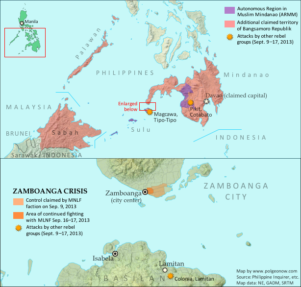
Claims and territorial control of the MNLF rebels/Bangsamoro Republik. Map by Evan Centanni.
|
Updates on the world's countries and borders
Tuesday, September 17, 2013
Bangsamoro Republik? Philippine Separatists Seize Territory (map)
Zamboanga City in the southwestern Philippines came under rebel attack last week, with insurgents seizing and occupying several neighborhoods. Because the fighters are from a rebel group that declared independence in August, their newfound territorial control might technically be considered the birth of a new breakaway state. Details and discussion below!
Wednesday, September 11, 2013
Rebel Control Map: Central African Republic's Counter-Rebellion (September 2013)
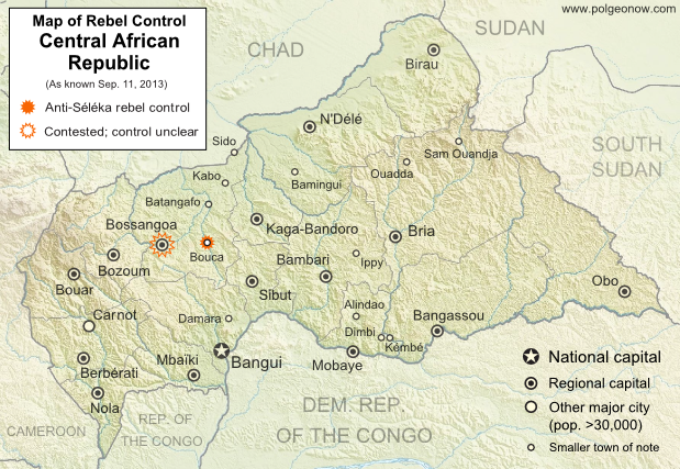 |
Rebellion and Counter-Rebellion
Starting last December, a rebel coalition called Séléka swept across the Central African Republic from the north, capturing much of the country by January (see our first map of rebel control in the CAR). After a short-lived attempt at peace, Séléka renewed its campaign, capturing the capital and forcing President François Bozizé to flee the country. Rebel leader Michel Djotodia declared himself president, and Séléka has remained the major power in the country despite outbreaks of violence and general chaos.
Thursday, September 5, 2013
Lies Your World Map Told You: 5 Ways You're Being Misled
Unfortunately, most world political maps aren't telling you the whole story. The idea that Earth's land is cleanly divvied up into nation-states - one country for each of the world's peoples - is more an imaginative ideal than a reality. Read on to learn about five ways your map is lying to you about borders, territories, and even the roster of the world's countries.
 |
The lines and coloring on this map are hiding major truths about the world's countries.
(Source: U.S. CIA; public domain) |
Thursday, August 22, 2013
Syria Civil War Map: August 2013 (#11)
There are newer versions of this map available. To see them, view all Syria updates.
Syria's civil war has continued to rage through the summer, with small changes in territorial control and the area of fighting. Here's the updated conflict map, plus a summary of recent territorial changes and other developments.
Syria's civil war has continued to rage through the summer, with small changes in territorial control and the area of fighting. Here's the updated conflict map, plus a summary of recent territorial changes and other developments.
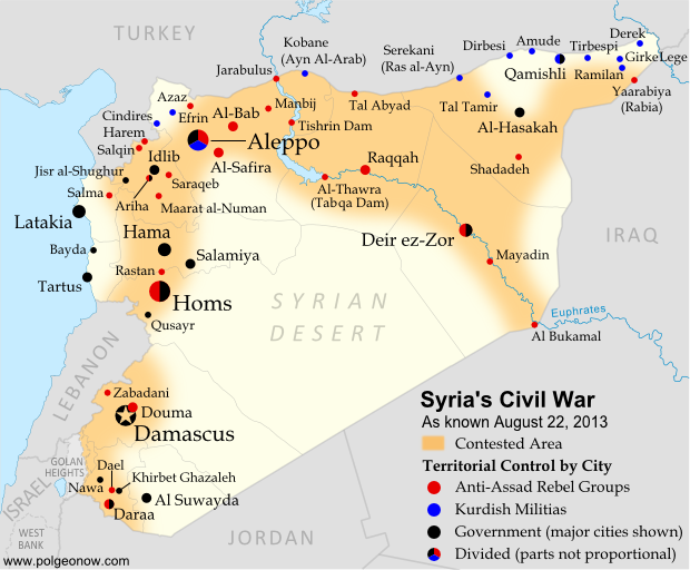 |
Area of fighting and territorial control in Syria's civil war, updated for August 2013. Map by Evan Centanni, starting from this blank map by German Wikipedia user NordNordWest. License: CC BY-SA
|
Thursday, August 15, 2013
Map: Kosovo Recognized by 4 More Countries (101/193)
 |
| Countries recognizing the Republic of Kosovo in green, with the four most recent additions highlighted. Disputed recognitions in yellow. Kosovo in magenta. Map by Evan Centanni, modified from public domain graphic (source). |
Subscribe to:
Posts (Atom)