Showing posts with label intergovernmental organizations. Show all posts

Thursday, May 9, 2013

Who Recognizes Palestine in 2013?

(Keep up with changes to Palestine's situation: view all Palestine updates.)

 Palestine is now an Observer State in the U.N., but it's still not recognized individually by all U.N. member countries. Read on for more about the latest countries to recognize Palestine, plus other recent changes to its international status.
Map of countries that recognize the State of Palestine as an independent country, updated for May 2013 with most recent additions highlighted
Countries recognizing the State of Palestine in green, with most recent additions highlighted in lighter green. Palestine in magenta (circled). Map by Evan Centanni, modified from public domain graphic (source).

Wednesday, March 6, 2013

Map: Laos and Tajikistan Join WTO

Map of World Trade Organization (WTO) member countries, updated for March 2013 to include new members Laos and Tajikistan
World Trade Organization members in green. New members Laos and Tajikistan highlighted (click to enlarge). Map by Evan Centanni, modified from this Wikimedia map by Muso (license: CC BY-SA).

Wednesday, February 13, 2013

The Political Geography of Chocolate - A Valentine's Day Special

Valentine's Day is just around the corner, and if you thought you were getting a break from geography for sweets and smooching, think again! Political Geography Now presents an introduction to chocolate-based global intergovernmental organizations...

World map showing membership in chocolate-related intergovernmental organizations, the Alliance of Cocoa Producing Countries (COPAL) and the International Cocoa Organization (ICCO)
Map by Evan Centanni, starting from public domain blank world map (source).
International Chocolate Organizations
You've heard of the U.N., the E.U., and the WTO - but those are only some of the most well-known (i.e. boring!) global intergovernmental organizations. This Valentine's Day, you can take a few minutes to learn about the political geography of chocolate - we'll look at two organizations built around the global trade in cocoa beans, the raw ingredient used in making our favorite sweets.

Thursday, December 6, 2012

Is Palestine Really a Country?

(Keep up with changes to Palestine's situation: view all Palestine updates.)

Palestine is now recognized as a country by both the U.N. and a majority of its members, but many  have questioned whether this new-found status reflects the truth on the ground. Is Palestine really an independent country, or is this a political fantasy concocted by supporters in the U.N.?

The Olso Accords divided the Palestinian territories into three areas of control (see article for explanation). Map by Evan Centanni. Sources: Natural Earth, B'Tselem, U.N. OCHA oPt.
What is a "sovereign state"?
By the most common definition, a "state" has to have:
  1. A government
  2. A defined territory
  3. A permanent population
  4. The ability to conduct foreign relations with other states
This definition is called the "declarative theory of statehood", and was formalized in the Montevideo Convention of 1933. To be a "sovereign" state (i.e. an independent country), it's also important that the government answers to no other country, and that the territory and population are actually under the government's control.

A prospective country that fits these criteria is described by geographers as a de facto sovereign state, even if it's not recognized by the international community (de facto is Latin for "in actual fact").

Friday, November 30, 2012

Palestine Recognized as a Country by the U.N.

(Keep up with changes to Palestine's situation: view all Palestine updates.)

This Thursday, the U.N. General Assembly voted to change Palestine's status in the organization from "observer" to "observer state". This is the first time the international body has recognized Palestine as a state, giving it the same status enjoyed by U.N. non-member Vatican City. 

Map of Israel with the occupied territories of the West Bank, Gaza Strip, and Golan Heights highlighted
The State of Palestine claims the West Bank and Gaza, which are largely occupied by Israel. The Golan Heights are not part of the Palestinian Territories. Public domain map (source).
Until this Thursday, Palestine was a partially recognized country, acknowledged by some U.N. member nations, but not by the U.N. itself (See also: How many countries are there in the world?). Although its delegation has had observer status at the U.N. since 1974, it was never classified as a "state", being treated as something between a country and a non-government organization. Now, the organization has officially voted to change Palestine's status to "observer state" - effectively a recognition that it's an independent country, even though it's still not a U.N. member.

The Palestinian delegation campaigned to join the U.N. as a member last year, but had to give up after the U.S. promised to veto the application in the U.N. Security Council. Observer status, on the other hand, is determined by a majority vote in the U.N. General Assembly, which no single country can veto. That vote happened on November 29th, with members voting 138 to 9 in favor of granting Palestine observer state status (41 members abstained, and 5 were absent from the vote; see the full breakdown of national votes).

Tuesday, July 31, 2012

Venezuela Joins Mercosur, Paraguay Suspended

Map of intergovernmental organizations in South America: Mercosur, the Andean Community, and UNASUR (Venezuela and Paraguy indicated)
South America's intergovernmental organizations: Mercosur in green, the Andean Community (CAN) in (orange), and remaining members of UNASUR in blue (claimed territorial extents). Map by Evan Centanni, based on this map by Wikimedia user Luan.
After over six years of waiting, Venezuela today officially joined Mercosur (the "Southern Common Market"), one of South America's two main trade blocs.

The country was previously part of the continent's other major bloc, the Andean Community (CAN), but left that organization last year in anticipation of the switch to Mercosur (see Venezuela Leaves Andean Community).

By the time the Venezuela left CAN last year, its application had finally been approved by all Mercosur member states except for Paraguay; but despite support from that country's president, an opposition party in its congress continued to block Venezuela's entry into the trade organization.

Sunday, April 1, 2012

Mali Conflict Map: Separatists Capture Timbuktu and Gao (April 2012)

Country Name: Mali (English, French, Bambara)
Official Name: Republic of Mali (English), République du Mali (French)
News Category: Divided Countries
Summary: Tuareg-led rebels in northern Mali have now completed their control of the region's major cities, after capturing the military headquarters in Gao as well as historic Timbuktu. Meanwhile, Mali has been suspended from regional organization ECOWAS in response to the recent coup d'etat in the capital, Bamako.

Map of Tuareg rebellion in Northern Mali (Azawad), showing towns controlled by the MNLA rebel group as of April 1, 2012
Towns captured by the Tuareg-majority MNLA rebel group in Mali. Modified from Wikimedia map by Orionist, incorporating images by Carport and NordNordWest (source). License: CC BY-SA.
Full Story: Mali Divided by Separatist Fighting; all Mali map updates

Conflict Update
Again immediately following our last update, northern Mali's National Movement for the Liberation of Azawad (MNLA), made up mostly of Saharan Tuareg people, has followed its victory in Kidal by capturing the region's other two major cities. On March 31, the rebels took control of Gao, headquarters of the Malian military in the north, and the next day overran Timbuktu, a historic former trading post and modern tourism destination. The town of Aguelhok in the north is now also being reported as under Tuareg control, though it is unclear when it was recaptured (the rebels had previously taken and lost it again back in January).

The military government of Mali, which took over in a recent coup d'etat, has now withdrawn its forces from most of northern region, known to the Tuareg rebels as Azawad. Neighboring countries have offered military assistance only if the country returns to democracy, and have suspended Mali's membership in the Economic Community of West African States (ECOWAS) while imposing tough sanctions. If help doesn't come soon, the MNLA could be in the position to declare independence in the north, making Azawad Africa's newest country.

Follow events as they develop on Political Geography Now! To see only stories about this ongoing conflict, filter posts using the Mali label.

Seen this map on Wikipedia?
While Political Geography Now sometimes uses free maps from Wikipedia or other sites (after double-checking their sources), we also occasionally post our own maps to Wikipedia and Wikimedia Commons for others to use. The first version of this particular map of the Tuareg-led rebellion in Mali was created for Wikipedia by Orionist, but I have since taken charge of keeping it updated, with a bit of help from Mnmazur on Wikimedia Commons (Mnmazur is not associated with Political Geography Now).

Wednesday, March 28, 2012

Mali Conflict Map: Separatists Gain Ground in North (March 2012)

Country Name: Mali (English, French, Bambara)
Official Name: Republic of Mali (English), République du Mali (French)
News Category: Divided Countries
Summary: The rebellion of Tuaregs and other ethnic groups in northern Mali has continued gaining territory, and now threatens major cities in the north, where the rebels seek to establish an independent country called Azawad. Meanwhile, Malian military leaders upset with their government's handling of the rebellion have taken over the country in a coup, leading to increased chaos on the country's suspension from the African Union.

Map of Tuareg rebellion in Northern Mali, showing towns controlled by the MNLA rebel group
Towns captured by the Tuareg-majority MNLA rebel group in Mali. Modified from Wikimedia map by Orionist, incorporating images by Carport and NordNordWest (source). License: CC BY-SA.
Full Story: Mali Divided by Separatist Fighting

Conflict Update
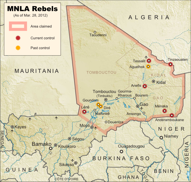
After a month with no territorial gains or losses reported, on March 11 the National Movement for the Liberation of Azawad (MNLA) captured of the town of Tessalit in Mali's far north. Home to a major military base and an airport, Tessalit was a major prize for the rebels, most of whom come from the traditionally nomadic Tuareg ethnic group. Their push for independence continued two days later with the storming of Diré and Goundam, two towns near the major northern city of Timbuktu, though it is unclear whether those two towns are still occupied by the MNLA.

Map of the African Union, marking suspended members Mali and Madagascar
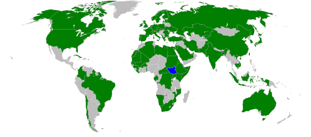
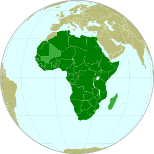
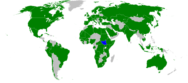
The African Union (green) with suspended members
Mali and Madagascar in lighter green. Modified from
this Wikimedia map (public domain).
An unexpected turn of events came on March 21, when the Malian government fell in a military coup. The leaders of the takeover cited President Amadou Toumani Toure's ineffectiveness at combating the Tuareg revolt in the north as their reason; ironically however, the chaos caused by the coup has proved beneficial to the rebels, who on March 23 captured the town of Anefis on the road between Gao and Kidal, two of the north's major cities. The MNLA has boasted that it will soon take those two cities, as well as Timbuktu, and recently it has indeed been reported that Malian troops in Kidal are negotiating a surrender after the city was surrounded by Tuareg militias.

In the confusion, another Tuareg-led rebel group, the Islamist Ancar Dine, has also claimed to control the towns of Tinzaouaten, Tessalit, and Aguelhok, which according to most other sources are actually held by the MNLA. Though the two rebel groups have a share a history of being formed by leaders of former Tuareg rebellions, some local experts doubt that they are actually working together. Meanwhile, the coup in Mali's capital city of Bamako has resulted in the country's suspension from the African Union (AU), an important regional organization which includes every country in Africa except for Morocco. Mali is one of only two currently suspended AU states, the other being Magascar, which also experienced a coup d'etat several years ago.

(Note: For updates to the Mali conflict map, follow the Mali label on Political Geography Now.)

Wednesday, February 1, 2012

Syria Divided by Armed Conflict (Feb. 2012)

There are newer versions of this map available. To see them, view all Syria updates.

Country Name: Syria (English), Sūriyya/Sūryā (Arabic)
Official Name: Syrian Arab Republic (English), al-Jumhūriyyah al-‘Arabīyah as-Sūriyyah (Arabic)
News Category: Divided Countries, Intergovernmental Organizations
Summary: Ten months in Syria's popular uprising, parts of the country have fallen out of government hands and into the control of the "Free Syrian Army," a group made up mostly of defectors from the national military. Meanwhile, Syria has been been suspended from the Arab League due its government's failure to stop using violence against unarmed protesters.

Known areas of armed activity for the rebel "Free Syrian Army" - many rural areas may be under full rebel
control. Unarmed protests, much more widespread than armed rebel activity, are not shown here. Map is my
own work, starting from this blank map by German Wikipedia user NordNordWest. License: CC BY-SA (Corrected
Feb. 26, 2012 for partial Hama control and eastern region activity; again on Mar. 9, 2012 for Rastan control.)


Full Story
The "Arab Spring" has brought incredible upheaval to the the Middle East and North Africa - first the Tunisian and Egyptian dictatorships fell to peaceful protesters; then Libya became embroiled in a civil war, while Yemen too began to fragment under opposing forces. Now, Syria has become the third country in the region to be divided between warring armies, as the 10-month-old uprising has given way to formidable armed resistance from a growing network of military defectors calling themselves the "Free Syrian Army" (FSA).

Wikipedia: Arab Spring

Even before the armed resistance began in earnest last September, the Syrian government and its president, Bashar al-Assad, were making headlines with their brutal crackdowns on peaceful protesters, along with tank-led sieges of disobedient cities. After six months of government violence, the FSA rebels burst onto the stage with a successful, if temporary, takeover of the anti-government city of Rastan (See News Bits: October 2011). They were eventually driven out of Rastan, and moved their headquarters across the border into Turkey, using the next three months to slowly consolidate control over the northwestern province of Idlib, while also gaining ground in the city of Homs and the provinces of Hama and Daraa. [Update: The FSA took control a of Rastan a second time just as this post was being written.]
Map of the Arab Spring. Protests, and in some cases full scale revolutions, have reached across the entire Arab
World. Map is from this Wikipedia page (public domain; original graphic).
All the while, the rebels were hitting targets closer and closer to the capital city of Damascus, until finally in January they successfully seized the nearby city of Zabadani. Fighting around the capital escalated quickly, with the FSA spreading its control across most of the suburbs of Damascus by January 27. Over the next few days, Assad's government launched a largely successful offensive to take back the areas surrounding the capital, though the rebels still claim control of Douma, Damascus's most populous suburb. The cities of Homs and Idlib are also reported to be largely under FSA control, along with much of rural Idlib province. And the territorial division in Syria may be even more extensive than we know - journalists have been forbidden to enter the country, making it difficult to follow developments on the ground.

Wikipedia: 2011–2012 Syrian uprising

The Arab League, with Syria in lighter green at top right.
Map by Danalm000, from Wikimedia (license: CC BY-SA)
Arab League Involvement
The League of Arab States (better known as the Arab League), an international organization of which Syria is a founding member, has taken a close interest in the events unfolding within the country. In November, the body voted to suspend Syria's membership unless President Assad brought an end to the violence against civilian protesters. Assad failed to follow through with any concrete action, and the country was suspended from the League. In January, the organization sent a delegation of observers into Syria to examine the situation; they were allowed inside the country, but eventually were forced to leave due to escalating violence between government forces and the FSA. As the region's main representative body, the Arab League will likely be a major player in any future decisions by the international community to intervene in Syria's civil war.

Wikipedia: League of Arab States

Wednesday, December 21, 2011

WTO Admits New Members

Organization: World Trade Organization
Countries in Question: Vanuatu, Russia, Montenegro, Samoa
News Categories: Intergovernmental Organizations
Summary: The World Trade Organization, the intergovernmental organization supervising international trade between the majority of the world's countries, admitted one new member last October, and three more last week. Especially notable was the admission last Friday of Russia, which was by far the largest economy not to have joined previously.

Full Story
While some intergovernmental organizations, such as the U.N. or regional unions, were created for general purposes of cooperation between states, others serve more specific purposes. The World Trade Organization (WTO) is one of these, acting as a venue for countries to agree on rules for international trade. Among its members, economic agreements are subject to rules aimed at liberalizing international trade, and trade-related disputes are also arbitrated through the organization. Formed in 1995 as a replacement for weaker trade treaties of the past, by 2008 the WTO represented approximately 80% of the world's independent countries.

World Trade Organization members in green. Countries joining this year in brighter green, with small countries circled. Modified from this Wikimedia map (license: CC BY-SA).


This October, the WTO grew for the first time in three years, with the acceptance of the Pacific island country of Vanuatu's as a member. Just last week, three more countries joined: Russia, Montenegro, and Samoa. Samoa is another small Pacific island country, and Montenegro was only formed a few years ago from the final breakup of former Yugoslavia. Russia, however, has gained much attention for being the last of the world's major economic powers to join the organization. Although it first applied for admission to the group 18 years ago, before the modern WTO was even formed, until recently Russia was slow to proceed with membership negotiations. For the last few years, it was blocked from entry by Georgia, a WTO member protesting its invasion by Russia during the 2008 war between the two countries, but that hurdle was finally crossed after a Swiss-brokered agreement between Russia and Georgia earlier this year. Although the four new countries have been accepted by the organization, their governments will still have to ratify the agreements in order for them to become full participating members.

Friday, July 29, 2011

South Sudan Joins African Union

Country Name: South Sudan
Official Name: Republic of South Sudan
News Categories: Intergovernmental Organizations
Summary: New U.N. member South Sudan has been admitted into the African Union, the continent's highest level intergovernmental organization. Formal recognition from individual countries is still continuing.
South Sudan (blue) in the A.U. (green). Modified from
this map by Wikimedia user Heraldry (CC BY-SA).

See Also: New Country: South Sudan

Full Story
Less than three weeks after declaring independence, the new Republic of South Sudan has been admitted into the African Union (A.U.). The A.U., which represents all of Africa's countries except for Morocco, voted with a majority in favor of allowing South Sudan's entrance into the organization. Membership will allow the new state to participate fully in the community of African nations, while the A.U. is soon to begin mediating talks over the remaining disputes between South Sudan and Sudan, the country from which it seceded this month. South Sudan is the 54th member of the African Union, and the first new member since Eritrea joined in 1993.
Map of South Sudan from the CIA
World Factbook
(public domain).

See Also: South Sudan Joins U.N.

In addition to A.U. and U.N. membership, South Sudan has continued to receive recognition from individual countries. Official statements of recognition for the new country have now been released by 97 U.N. members and six other sovereign states. Ninety-five U.N. member countries have not yet formally recognized South Sudan, but none have opposed it's independence - an indication that they all intend to accept it as the world's newest sovereign state.


Countries which have officially stated their recognition of South Sudan's sovereignty (green). South Sudan in blue. Modified from this Wikimedia map (public domain).

Wikipedia: South Sudan, Foreign Relations of South Sudan, African Union

Friday, July 22, 2011

South Sudan Joins U.N.

Country Name: South Sudan
Official Name: Republic of South Sudan
News Categories: Intergovernmental Organizations, New Countries
Summary: The newly independent Republic of South Sudan was admitted into the United Nations (U.N.) last week, effectively giving it full status as a nation-state in the international community. Diplomatic recognition from individual countries is still continuing, though the process is now little more than a formality.
U.N. headquarters in New York fly South Sudan's flag
after accepting the new state as a member. U.N. photo
used in accordance with official usage policy (source).

See Also: New Country: South Sudan

Full Story
Just five days after officially declaring independence, the new Republic of South Sudan has been welcomed as the 193rd member of the United Nations. The small African country received membership through a unanimous vote of the U.N. General Assembly on July 14th, following a recommendation from the U.N. Security Council the day before, which was also unanimous. Membership will allow the new state to participate fully in the U.N. and all of its associated organizations, and gives it the legitimacy required for a guaranteed place on world maps and lists of the world's countries.

See Also: How many countries are there in the world? (UPDATED)

In addition to U.N. membership, South Sudan has continued to receive recognition from individual countries. Approximately 88 U.N. members and six other sovereign states have now made official statements recognizing the new country. Although that still leaves 104 U.N. member countries which have not yet formally recognized South Sudan, the unanimous vote of the U.N. General Assembly suggests that all members do intend to acknowledge its legitimacy, whether by official decree or not. No state has indicated any intention to oppose the new state's independence.

Countries which have officially stated their recognition of South Sudan's sovereignty (green). South Sudan in blue. Modified from this Wikimedia map (public domain).

Wikipedia: South Sudan, Foreign Relations of South Sudan, United Nations
 

Thursday, April 28, 2011

Venezuela Leaves Andean Community

Country Name: Venezuela (English, Spanish)
Official Name: Bolivarian Republic of Venezuela (English), República Bolivariana de Venezuela (Spanish)
News Category: Intergovernmental Organization Membership
Summary: Venezuela has withdrawn from the Andean Community (CAN) customs union, in favor of joining Mercosur, another union in South America. The switch has been represented as a protest against free trade agreements made with the United States on the part of CAN members Peru and Colombia. Admission into Mercosur is still pending, though Venezuela remains a member of the Union of South American Nations (UNASUR).

Venezuela (red) has left CAN (orange) in anticipation of joining
Mercosur (green). Other UNASUR members are in blue. Map
includes all claimed territories of the member states. My own
work, based on this map by Wikimedia user Luan (terms of use).

Full Story
Although nation-states are usually considered the basic units of the modern political globe, it has become common in recent decades for countries to work together towards integration at a higher level. The most well known case, and probably the furthest advanced, is the European Union. However, there are a number of other intergovernmental organizations working for integration in other parts of the world. In South America, supranational integration has progressed largely through two major trade blocs: the Southern Common Market (known by its Spanish or Portuguese abbreviations, "Mercosur" or "Mercosul") and the Andean Community (known by the Spanish abbreviation, CAN).

The Andean Community represents a group of countries in the northwestern part South America, while Mercosur is centered around the southeastern region of the continent. The country of Venezuela, located in the north of the continent at the meeting place of the two blocs, has long been a member of the Andean Community. However, in 2006 the Venezuelan government announced the intention to switch its membership to Mercosur. Citing free trade agreements made between the United States and CAN members Peru and Colombia, Venezuelan president Hugo Chávez announced that he believed CAN was no longer relevant. After five years, Venezuela fully withdrew this month from the Andean Community. Admission to Mercosur is still pending, though it seems likely in the near future.

CAN and Mercosur have both implemented trade agreements forming customs unions between their members - that is, they have mostly eliminated tariffs between member countries, and have also unified their external customs regulations to be consistent among the whole bloc. They have also proceeded with other cooperative programs, such as coordinating economic policies and setting up courts with international jurisdiction. Over the last decade, they have been working towards integrating with each other to form the Union of South American Nations (USAN or UNASUR/UNASUL), an organization modeled after the European Union. In fact, UNASUR includes all of South America's sovereign states, independently of their membership in CAN or Mercosur, which means that Venezuela will remain a member of UNASUR during its transition period. Venezuela's bid to join Mercosur had originally been seen as a gesture towards integration between Mercosur and CAN, though that is clearly not the case now that the country has withdrawn from CAN.


Wikipedia:
Venezuela
Andean Community (CAN)
Southern Common Market (Mercosur)
Union of South American Nations (UNASUR)