Thursday, June 12, 2014

World Cup 2014: Which Countries Are (and Aren't) Members of FIFA?

There are newer versions of this explainer available. To see them, view all FIFA World Cup articles on PolGeoNow.

 
World map showing the six continental confederations of national association football (soccer) teams, including all teams eligible for the World Cup
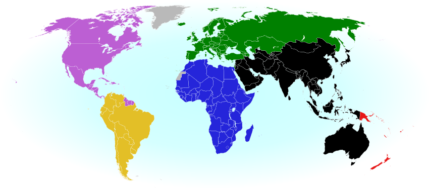
The six continental confederations of national football teams associated with FIFA. Not all confederation members are individually members of FIFA. Map by Evan Centanni, based on work by EOZyo (source).
Football/soccer fans around the world are tuning in tonight for the beginning of the month-long FIFA World Cup in Brazil. But how much do you know about which teams can compete? Which countries were eligible to enter the tournament, and which are excluded? Read on for an exclusive guide to the roster of FIFA national football teams...

Premium members click here to view this article in the ad-free members area. Not a member yet? Subscribe now!

Sunday, June 8, 2014

Palestine: West Bank and Gaza Reunited Under Transitional Government

(Keep up with changes to Palestine's situation: view all Palestine updates.)

Map of the State of Palestine in the West Bank and Gaza Strip, including both its claimed borders (the Green Line) and zones of actual control (Areas A, B, and C from the Oslo Accords)
Control zones based on the Oslo Accords. Area A: Palestinian control; Area B: mixed Israeli-Palestinian control; Area C: full Israeli control. Map by Evan Centanni (sources: Natural Earth, B'Tselem, U.N. OCHA oPt).
Premium members click here to view this article in the ad-free members area. Not a member yet? Subscribe now!

By Evan Centanni

Unity Government
The partially-unrecognized State of Palestine is not only divided between Palestinian and Israel control - even the Palestinian-administered areas have been governed separately for several years now. However, this month rival parties Hamas and Fatah have finally come together to reunite the West Bank and Gaza Strip under a single Palestinian government.

Divided Country
The rift in control opened up in 2007, after religious militant group Hamas won a majority of seats in the 2006 Palestinian legislative elections. Hamas and Fatah, the current ruling party at the time, failed to form a stable unity government then, and the conflict between them escalated into a short civil war in the Gaza Strip. 

See Also: Is Palestine Really a Country?

Tuesday, May 27, 2014

Iraq: Updated Map of ISIS Control (Premium)

There are newer versions of this map available. To see them, view all Iraq updates.
 
Map of territorial control in Iraq in May 2014, including cities and countryside held by the Islamic State of Iraq and al-Sham (ISIS, ISIL) as well as areas administered by the Kurdistan Region. Includes detail of towns in flashpoint provinces of Anbar and Diyala

Download PDF
buy


(Subscribe via Paypal)
This is our first update to January's map of Al Qaeda control in Iraq. The map has been expanded to show much more detail of the ongoing campaign of control by the Islamic State of Iraq and al-Sham (ISIS), now no longer an Al Qaeda affiliate.

This map and article are exclusive premium content, available only to members or for individual purchase. Buy now (US$9.99).


 Premium map includes:
  • Territorial control in Iraq by city, color coded for government, ISIS, or Kurdistan
  • Detail of ISIS control and attempted control in small towns, including in the eastern flashpoint province of Diyala
  • Inset map with extra detail for Anbar province, where ISIS controls the most populated territory
  • Indications of estimated ISIS control/influence in the countryside
  • Article summarizing events since January, explaining the information on the map, and providing in-line links to the sources of information
Members click here to proceed to article and map

Not a member yet? Subscribe Now!


Saturday, May 3, 2014

Mayotte Enters European Union

"Outermost regions" are officially part of the European Union; "overseas countries and territories" are not part of the EU itself, but have special relations with it because of their connections to member countries. New outermost region Mayotte is located in southeastern Africa. Map from Wikimedia Commons © Alexrk2 (CC BY-SA)
Premium members click here to view this article in the ad-free members area. Not a member yet? Subscribe now!

Article by Evan Centanni

EU Expands to Include Mayotte
You probably heard about Croatia joining the European Union last year, but did you know the EU expanded further this year...in Africa? The French overseas department of Mayotte, a group of islands in the Indian Ocean northwest of Madagascar, became officially part of the EU on January 1.

Thursday, April 24, 2014

Syria Civil War Map: April 2014 (#12.2) (Premium)

There are newer versions of this map available. To see them, view all Syria updates.

Map of territorial control in Syria's civil war, updated for April 2014. Shows control by government, rebels, ISIS extremists, and Kurdish militias. Includes important sites of recent fighting such as Yabroud, Maloula, Kasab, Azaz, Morek, Al Bukamal, and more.

Download PDF
buy


(Subscribe via Paypal)
PolGeoNow's popular Syria civil war control maps are back! Here's the second of our member-exclusive premium updates. 

Developments since our previous Syria map update in January include advances by both the government and the rebels, as well as changes in territorial control for the Islamic State of Iraq and Syria (ISIS).

This map and article are exclusive premium content, available only to members or for individual purchase. Buy now (US$9.99).

Premium article includes:
  • Map of current territorial control in Syria by city, color-coded for the Assad government, rebel groups, ISIS extremists, and Kurdish militias
  • Map includes recent areas of fighting such as Yabroud, Maloula, Kasab, Azaz, Al Bukamal, and more
  • Article summarizing changes since January, with links to the sources of information
Members click here to proceed to article and map

Not a member yet? Subscribe Now!