Thursday, July 16, 2020

Which Countries Used the Euro in 2020? (Map of the Eurozone)

There's a newer version of this map and article available. You can always find the latest version at this link: Which Countries Use the Euro Today? (Map of the Eurozone)

This is the archived 2020 version of our Eurozone map and explainer article, which itself was updated from an article originally published in June 2016, with the earliest version of the map appearing in a 2014 news post.

Map of the Eurozone (euro area), showing which countries use the euro as their currency. Includes members, pre-members (ERM II or ERM-2 waiting area), EU non-members using the euro, and other EU countries (color blind accessible). Updated for July 2020 with the entry of Croatia and Bulgaria into the ERM-II.
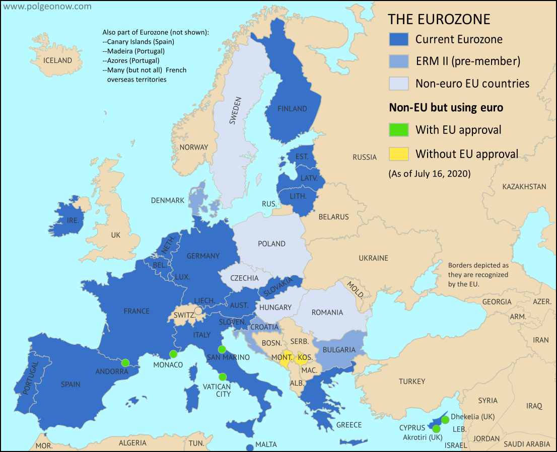
The Eurozone, European Union, and other countries using the euro.
Map by Evan Centanni, from blank map by Ssolbergj. License: CC BY-SA

Article by Caleb Centanni, with additional content by Evan Centanni 

What is the Eurozone?

Officially called the "euro area", the Eurozone is a nickname for the group of countries in Europe that share a single currency, called the euro. The euro currency is administered by the European Union (EU), but many countries in the EU don't use the euro, and some countries outside the EU do use it. The European Central Bank, the governing financial body of the Eurozone, is headquartered in Frankfurt, Germany. Germany, along with eleven other EU countries, became a founding member of the Eurozone in 1999.

Sunday, July 12, 2020

NAFTA Replaced With USMCA/CUSMA

CUSMA/USMCA replaces NAFTA as the new free trade area made up of Mexico, the US, and Canada. Map by Wikimedia user Heraldry (source; CC BY-SA)

NAFTA is No More

On July 1, the North American Free Trade Agreement (NAFTA) - a much-talked-about free trade area including Mexico, the United States, and Canada - was formally retired. The arrangement, in place since 1994, has been replaced by a similar deal, technically called the "Agreement Between the United States of America, the United Mexican States, and Canada". The change was agreed upon last year, but didn't take effect until this month.

USMCA or CUSMA?

The short name of the deal depends on who you ask. In the US, it's called the United States-Mexico-Canada Agreement (USMCA), but in Canada it's the Canada-United States-Mexico Agreement (CUSMA). In French (Canada's other official language) the acronym is ACEUM - also placing "Canada" first - and in Mexico it's known by the Spanish acronym T-MEC (placing "Mexico" first).

Sunday, July 5, 2020

US State of Mississippi Now Has No Flag

Update: On November 3, 2020, Mississippi voted to approve a replacement flag, which was then officially adopted on January 11, 2021.


The second flag of the US state of Mississippi, stripped of official status on June 30, 2020
Former official flag of Mississippi state (2001-2020)

The Mississippi Flag is No More

Last Tuesday the elected governor of Mississippi, one of the 50 states of the United States of America, signed a new law stripping official status from the state's controversial flag.

Mississippi's was the only remaining state flag to include the Confederate battle emblem, a symbol of the separatist Confederate States of America who fought to preserve slavery in the country's 1860s civil war.

Though citizens are not banned from flying the flag - a right protected by the US Constitution - it has been taken down from both the state government building and the US Capitol in Washington, DC. Several city governments and universities in Mississippi had already stopped flying the state flag.

Wednesday, July 1, 2020

Israel / Palestine Map: Who Controlled What in 2020?

This is the original version of PolGeoNow's Israel/Palestine administrative control map, as published in July 2020. An improved version is now available as of May 2021 (there have been no changes to the lines of control).

Who controls Palestine and Israel's claimed territories today (June 30, 2020), just before Israel's planned annexation of parts of the West Bank? Also file under: Palestine controlled area map. Includes bigger West Bank map (Areas A, B, C). Map also includes Gaza Strip, Golan Heights, major cities and Israeli settlements, UN peacekeeper deployments (UNIFIL and UNDOF), no man's land, Golan Heights buffer zone (area of separation, AOS), and Shebaa Farms. Colorblind accessible.
Click to enlarge. Map by Evan Centanni, incorporating base map by Koen Adams of onestopmap.com and data from B'Tselem's interactive mapping project. (Contact us for permission to use this map.)

The explanatory article accompanying this map has been revised and updated, and can now be found at the following link: Israel / Palestine Map: Who Controls What in May 2021?

Monday, June 22, 2020

Libyan Civil War Map & Timeline: Tables Turned in Tripoli - June 2020 (Subscription)

SUBSCRIBERS CLICK HERE TO PROCEED TO ARTICLE AND MAP

There are newer versions of this map available. To see them, view all Libya updates.

Research by Djordje Djukic. Map by onestopmap.com, Evan Centanni, and Djordje Djukic.

Subscribe for full access to all conflict map reports!

Libya: Who controls what? A concise, professional map of who controls Libya now (June 2020). Shows detailed territorial control in the Libyan Civil War as of June 21, 2020, including all major parties (Government of National Accord (GNA); Tobruk House of Representatives, General Haftar's Libyan National Army (LNA), and allies; Tuareg and Toubou (Tebu, Tubu) militias in the south; and the so-called Islamic State (ISIS/ISIL)). Includes terrain, major roads, and recent locations of interest including the Tripoli International Airport, Tarhuna, Bani Walid, Qurayyat, and more. Colorblind accessible. Over the past few weeks, the tables have turned dramatically in western Libya, with the LNA driven completely out of its footholds within the city of Tripoli, and expelled from almost the whole northwest. 

See all this and more on the latest update to PolGeoNow's concise, professional Libyan Civil War control map, which comes with a timeline of changes since our previous Libya control map report of May 29, 2020.

This map and report are premium content available to paid subscribers of the PolGeoNow Conflict Mapping Service.

Want to see before you subscribe? Check out our most recent FREE SAMPLE Libya map!

Exclusive report includes:
  • Up-to-date map of current territorial control in Libya, color-coded for the UN-backed Government of National Accord (GNA), the rival Tobruk parliament and Khalifa Haftar's Libyan National Army (LNA), the so-called "Islamic State" (ISIS/ISIL), and Toubou and Tuareg militias in the south. Colorblind accessible.
  • Detailed indication of city-by-city control, including key towns and other locations important to current events.
  • Locations of recent fighting and changes of control, including the Tripoli International Airport, Tarhuna, Bani Walid, Qurayyat, and more.
  • Detailed timeline of important events and changes to territorial control since May 29, 2020, with links to sources.

SUBSCRIBERS CLICK HERE TO PROCEED TO ARTICLE AND MAP

Not signed up yet? Click here to learn more about our professional subscription service!

Can I purchase just this map?
This map and report are not available for automated purchase to non-subscribers. If you need access or republication rights for only this map report, please contact service@polgeonow.com for options.