Tuesday, April 14, 2020

Schengen Border Controls in the Time of Coronavirus (April 14, 2020)

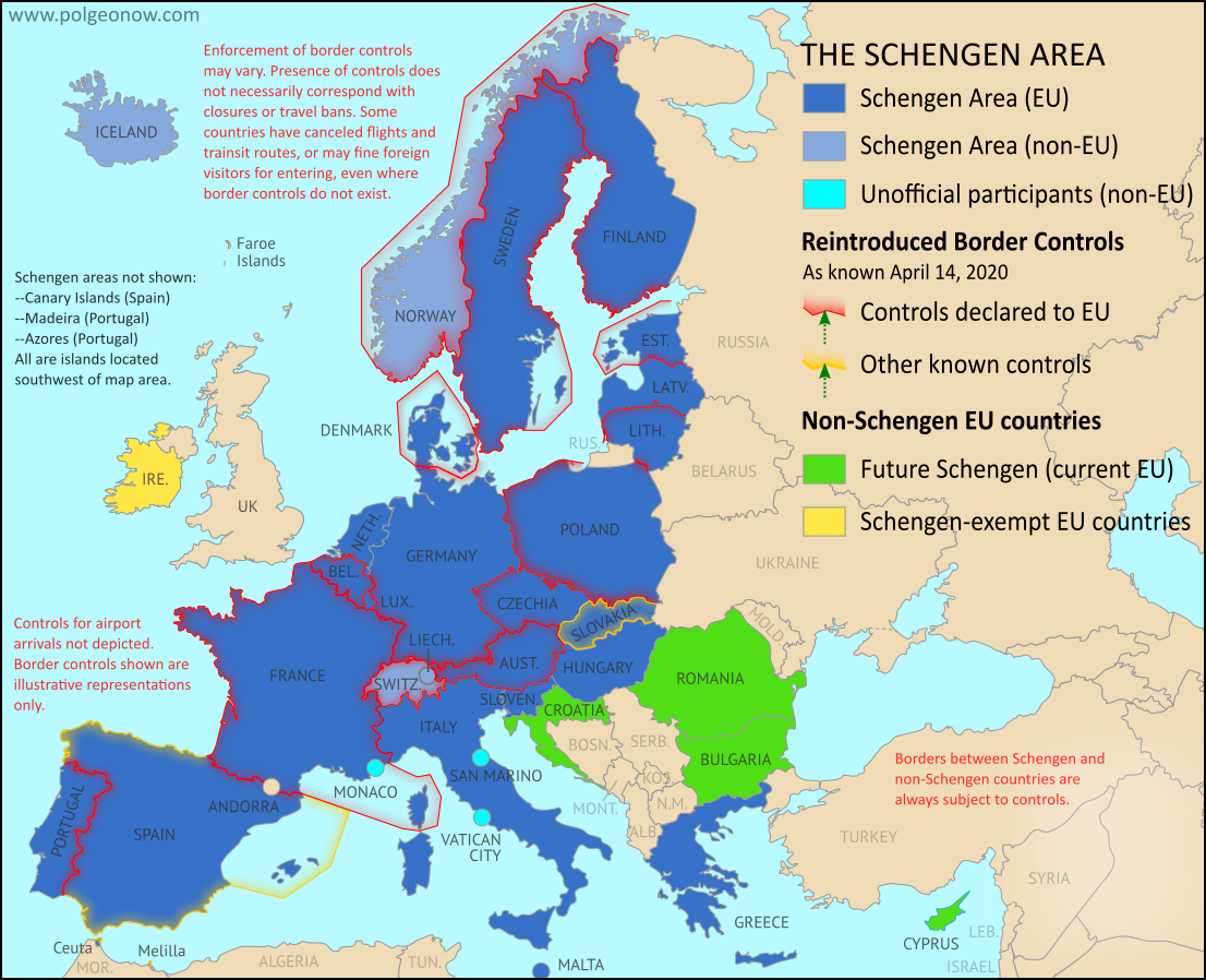
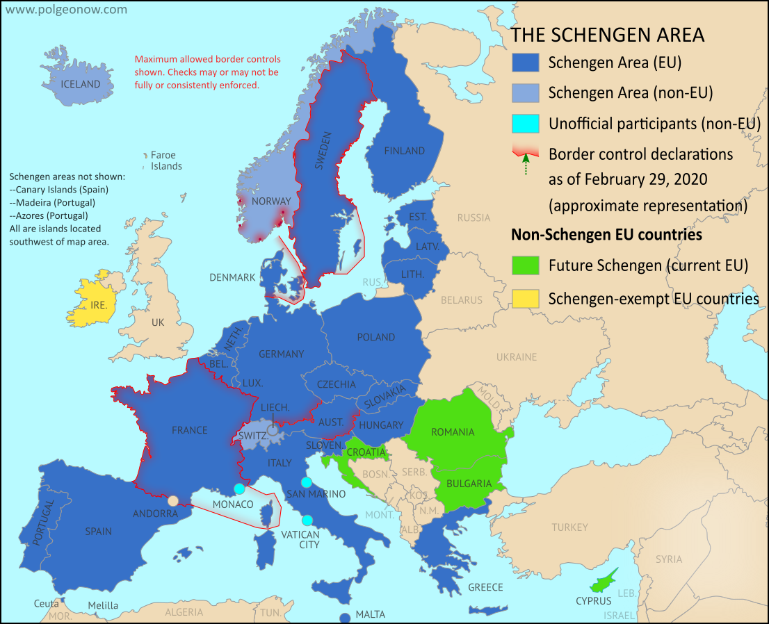
This map and article have been updated to April 14, 2020. You can also view the previous edition of the map, from March 27, with its accompanying timeline.

Since 2016, PolGeoNow has mapped reinstated border controls within Europe's Schengen free travel area, with the companion piece to this article covering changes from mid-2017 up to last month. Now, border controls between European countries have drastically expanded amid the global coronavirus pandemic. 

Read on for a country-by-country list of border controls and travel bans, plus a timeline of what went into effect when.

Schengen borders map showing temporary reintroduction of border controls in the Schengen Area (the European Union's border-free travel zone) as of April 14, 2020, during the widespread closure of internal Schengen borders due to the COVID-19 coronavirus pandemic. Also includes, in a different color, controls announced by governments where the EU has not been notified.
Map by Evan Centanni, from blank map by Ssolbergj. License: CC BY-SA
Article by Evan Centanni

Coronavirus-related Border Checks in the Schengen Area

As many travelers know, much of Europe is linked together as part of the "Schengen Area", a collection of countries that don't make travelers show any ID to cross the borders between them, and don't regulate what people bring across with them either (although this system is overseen by the European Union, the Schengen Area and the EU aren't the same thing). But under special circumstances, member countries can choose to temporarily resume border checks (also known as "border control").

Monday, April 6, 2020

Map: North Macedonia Joins NATO

Map of NATO allies in 2020, with all members including the newest country to join, North Macedonia (colorblind accessible).


Graphic modified by Evan Centanni from this map by Wikimedia user Addicted04 (CC BY-SA).

New NATO Ally: North Macedonia

Southeastern Europe's Republic of North Macedonia has been admitted as a full member of the North Atlantic Treaty Organization (NATO). Its membership officially went into effect on Friday, March 27, and a welcoming ceremony was held at the organization's headquarters the next Monday. North Macedonia is the 30th country to join NATO.

Membership had been promised to the country in exchange for striking a compromise in its dispute with NATO member Greece, who argued that the neighboring country was falsely claiming ownership of Greek history. Part of the deal, finalized in February 2019, was changing the country's name from "Republic of Macedonia" to "Republic of North Macedonia" - softening the implication that it's the heir to the ancient kingdom of Macedonia, which was mostly located in what's now Greece.

Sunday, March 29, 2020

Yemen Control Map & Report: Houthis Make Key Gains - March 2020 (Subscription)

SUBSCRIBERS CLICK HERE TO PROCEED TO ARTICLE AND MAP

There are newer versions of this map available. To see them, view all Yemen articles on PolGeoNow.

Timeline by Djordje Djukic. Map by Evan Centanni, Djordje Djukic, and onestopmap.com

Map of what's happening in Yemen as of March 2020, including territorial control for the unrecognized Houthi government, president-in-exile Hadi and his allies in the Saudi-led coalition, the UAE-backed southern separatist Southern Transitional Council (STC), and Al Qaeda in the Arabian Peninsula (AQAP). Includes recent locations of fighting and other events, such as Al-Hazm, Yatmah, Shahan, Durayhimi, al-Labanat base, and more.
Subscribe for full access to all conflict map reports!

Since February, Houthi forces have expanded their control in northern Yemen, putting the internationally-backed Hadi government on the defensive, even as the conflict between Hadi and formerly-allied separatists simmers on in the south.

See all this and more on the newest update to PolGeoNow's Yemen territorial control map, which includes a timeline of changes and important events since our previous Yemen map report in February.

This map and report are premium content available to paid subscribers of the PolGeoNow Conflict Mapping Service.

Want to see before you buy? Check out our most recent FREE SAMPLE Yemen map report!

Exclusive report includes:
  • Up-to-date map of current territorial control in Yemen, color-coded for the pro-Hadi coalition, the separatist Southern Transitional Council (STC), Houthi forces, and Al Qaeda in the Arabian Peninsula (AQAP).
  • Detailed indication of town-by-town control, including provincial boundaries, all major cities, and many smaller ones
  • Markers for recent areas of fighting, including Al-Hazm, Yatmah, Shahan, Durayhimi, and more
  • Timeline of changes to the situation since February 16, 2020, with links to sources 

SUBSCRIBERS CLICK HERE TO PROCEED TO ARTICLE AND MAP

Not a member yet? Click here to learn more about our professional subscription service!

Can I purchase just this map?
This map and report are not available for automated purchase to non-subscribers. If you need access or republication rights for only this map report, contact service@polgeonow.com for options.

Friday, March 27, 2020

Schengen Border Controls in the Time of Coronavirus (March 27, 2020)

This is an older edition of our Schengen Area border controls map, preserved here with its accompanying timeline for the historical record. To read the full article and see the current map and country-by-country list of border controls, visit our updated Schengen border controls article.

Schengen borders map showing temporary reintroduction of border controls in the Schengen Area (the European Union's border-free travel zone) as of March 27, 2020, during the widespread closure of internal Schengen borders due to the COVID-19 coronavirus pandemic. Also includes, in a different color, controls announced by governments where the EU has not been notified.
Map by Evan Centanni, from blank map by Ssolbergj. License: CC BY-SA
Article by Evan Centanni

Coronavirus: Schengen Border Controls Timeline March 1-27, 2020

Border controls have proliferated within Europe's "Schengen Area", where there's normally no ID check required to travel from one country to another. For more details, and to see a current map and list country-by-country list of official controls, visit our updated Coronavirus Schengen Border Controls article. Continue reading this article for the timeline of changes to official border controls from the beginning of the COVID-19 outbreak through March 27, as preserved from the previous edition of the article.

Map: Schengen Border Controls Before Coronavirus (2017-2020)

We mapped reinstated border controls within Europe's Schengen free travel area in March 2016, August 2016, February 2017, and August 2017, amid the past half-decade's surge of new refugee and immigrant arrivals. This article chronicles the history of the border checks from 2017 until just before the coronavirus pandemic of 2020. See the companion piece to this article for border controls during the coronavirus outbreak.

Schengen borders map showing temporary reintroduction of border controls in the Schengen Area (the European Union's border-free travel zone) as of February 2020, showing internal Schengen borders closed to passport-free travel just before the surge of new border controls enacted for the coronavirus outbreak. Map is also accurate for most of the period from from late 2019 through early 2020, and similar to the situation in 2018.

Changes to the way France is depicted compared to the previous map represent a stylistic adjustment, and not a change to the actual situation. Map by Evan Centanni, from blank map by Ssolbergj. License: CC BY-SA
Article by Evan Centanni

Border Controls Between Schengen Countries

As anyone who's visited Europe in recent decades knows, much of the continent is linked together as part of the "Schengen Area", a collection of countries that don't make travelers show any ID to cross back and forth across the borders between them - just walk on in (this system is overseen by the European Union, but the Schengen Area and the EU aren't the same thing). Though these borders are supposed to stay unregulated most of the time, the system does allow countries to temporarily reintroduce border controls under certain circumstances.