Saturday, September 30, 2017

Catalonia Voting on Independence: What Will Happen?

This article is part of our Referendum 2017 coverage, spotlighting controversial independence votes in two of the world's autonomous regions: Kurdistan voted for independence from Iraq this Monday, and Catalonia is about to vote on leaving Spain. 

Update: Check out the bottom of the article for a brief summary of what's actually happened since referendum day!

Catalonia and Spain: Map of Catalonia's location within Spain and relative to neighboring countries, including Spanish capital Madrid and Catalan capital Barcelona.
Map by Evan Centanni, based on this map by Mutxamel. License: CC BY-SA
By Evan Centanni

Catalonia Independence Vote

Catalonia, a self-governed region within Spain, is about to start voting on independence in a referendum that Spanish courts have ruled illegal. So what will happen? No one really knows, but we've taken our best shot at answering six of the big questions...

Referendum 2017: What is Catalonia?

This article is part of our Referendum 2017 coverage, spotlighting controversial independence votes in two of the world's autonomous regions: Kurdistan voted for independence from Iraq this Monday, and Catalonia will vote Sunday on leaving Spain. 

The following article is adapted from one originally published in 2013.

Catalonia and Spain: Map of Catalonia's location within Spain and relative to neighboring countries, including Spanish capital Madrid and Catalan capital Barcelona.
Map by Evan Centanni, based on this map by Mutxamel. License: CC BY-SA
By Omar Alkhalili, with additional reporting by Evan Centanni

Not Independent Yet: So What is Catalonia Now?

Catalonia is one of the "autonomous communities" of Spain (kind of like a state in the US), and also holds the official status of a "nationality" (but not "nation") within the Spanish system of government. Regions of Spain with this status are considered to be something similar to countries within the larger Spanish nation, allowing for their own separateness from Spanish mainstream culture without actually being independent.

Thursday, September 28, 2017

Syrian Civil War Map & Timeline: Siege of Deir ez-Zor Broken - September 2017 (Subscription)

SUBSCRIBERS CLICK HERE TO PROCEED TO ARTICLE AND MAP

There are newer versions of this map available. To see them, view all Syria updates.

Research by Djordje Djukic. Map by onestopmap.com, Evan Centanni, and Djordje Djukic

Subscribe for full access to all conflict map reports!

Map of Syrian Civil War (Syria control map): Fighting and territorial control in Syria in September 2017 (Free Syrian Army rebels, Kurdish YPG, Syrian Democratic Forces (SDF), Jabhat Fateh al-Sham / Hayat Tahrir al-Sham (Al-Nusra Front), Islamic State (ISIS/ISIL), and others). Includes Russia-Turkey-Iran agreed de-escalation zones and US deconfliction zone, plus recent locations of conflict and territorial control changes, such as Deir ez-Zor, Maadan, As Suwar, Aqerabat, and more. Colorblind accessible. In the past month, the territory of the so-called "Islamic State" (IS; formerly ISIS/ISIL) has continued to shrink rapidly, with the Russia-backed Assad government and the US-backed Syrian Democratic Forces (SDF) both rushing to secure Deir ez-Zor province in Syria's east.

See all this and more on the latest update to PolGeoNow's concise, professional Syrian Civil War control map, which includes a timeline of changes since our previous Syria map report in August, with sources cited.

This map and report are premium content, available to paid subscribers of the PolGeoNow Conflict Mapping Service.

Want to see before you subscribe? Check out our most recent FREE SAMPLE Syria map!

Exclusive map report includes:
  • Up-to-date illustration of current territorial control in Syria, color-coded for the Assad government, rebel groups, "Islamic State" (ISIS/ISIL) fighters, and Kurdish/SDF forces. Colorblind accessible.
  • Markers showing the approximate locations of Russian-Turkish-Iranian "de-escalation zones" and the one known US "deconfliction zone".
  • Special symbols indicating towns dominated by rebels of the former Al Qaeda Nusra Front (now Hayat Tahrir al-Sham) and US-backed Syrian Democratic Forces (SDF).
  • Detailed indication of city-by-city control, including key towns and other locations important to current events.
  • Locations of recent fighting and other important events, including Deir ez-Zor, Maadan, As Suwar, Aqerabat, and more.
  • Detailed timeline of important events and changes to territorial control since August 28, 2017, compiled by our Syria-Iraq expert, with links to sources.

SUBSCRIBERS CLICK HERE TO PROCEED TO ARTICLE AND MAP

Not signed up yet? Click here to learn more about our professional subscription service!

Can I purchase just this map?
This map and report are not available for automated purchase to non-subscribers. If you need access or republication rights for only this map report, contact service@polgeonow.com for options.

Tuesday, September 26, 2017

Kurdistan Votes to Leave Iraq: What Happens Next?

This article is part of our Referendum 2017 coverage, spotlighting controversial independence votes in two of the world's autonomous regions: Kurdistan voted yesterday on independence from Iraq, and Catalonia will vote this Sunday on leaving Spain. 


Map of Iraq and Kurdistan's place within it, published in advance of the 2017 Iraqi Kurdistan independence referendum. Includes disputed territories and territorial control as of July 30, 2017. Colorblind accessible.
Residents of Iraqi Kurdistan voted Monday in a controversial referendum on whether to declare independence from Iraq, with preliminary results showing almost 92% in favor of separation. We're still waiting for (hopefully) detailed official results so we can map out how different districts voted. But in the meantime, let's answer some of the big questions:

Will Kurdistan become independent now?

The Kurdistan region's government considers this vote official and "binding", in contrast to an informal 2005 referendum, even though the Iraqi federal government in Baghdad considers it completely illegal. But it was never intended to trigger an automatic declaration of independence.

Instead, Kurdistan leader Masoud Barzani has promised to use a "YES" vote as leverage to negotiate independence with Iraqi government. So far, no date has been set for Kurdistan's declaration of independence, and it could still be years away.

Friday, September 22, 2017

Referendum 2017: Iraqi Kurdistan Map

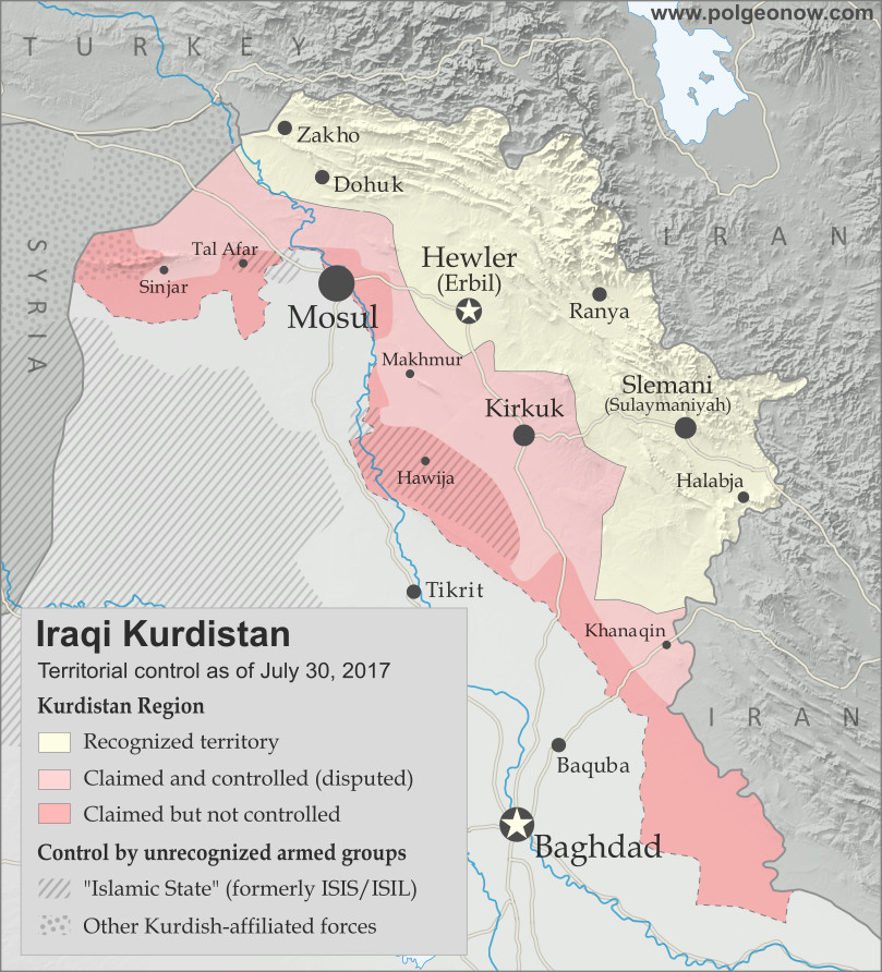
Two of the world's autonomous regions are about to vote in controversial independence referendums. Iraqi Kurdistan decides on independence from Iraq this Monday, and on October 1 Catalonia plans to vote on leaving Spain. PolGeoNow will be covering these events with a series of articles, but in the meantime we couldn't wait to share our new Iraqi Kurdistan map with you!

Map of Iraq and Kurdistan's place within it, published in advance of the 2017 Iraqi Kurdistan independence referendum. Includes disputed territories and territorial control as of July 30, 2017. Colorblind accessible.
Graphic by Evan Centanni and Djordje Djukic, incorporating base map by Koen Adams of onestopmap.com. All rights reserved.

Iraqi Kurdistan Independence Referendum

The Kurdistan Region of Iraq (Iraqi Kurdistan for short) is just part of the traditional homeland of the Kurds, the Middle East's fourth-largest ethnic group after Arabs, Persians, and Turks.

Many Kurds also live in Turkey, Syria, and Iran. But Iraqi Kurdistan is where they have the most legal rights, governing themselves in what's internationally recognized as an autonomous region within Iraq.

But all's not well in Kurdistan-Iraq relations. Iraqi Kurds suffered through horrific violence and persecution in the 1980s and 90s, and now the region's top politician has staked his reputation on separating Kurdistan from Iraq permanently.