 |
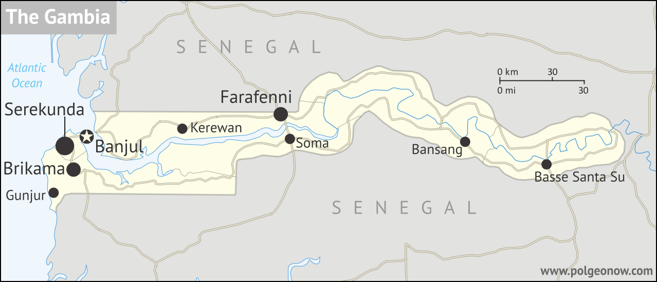
| Map by Evan Centanni. Contact for usage rights. |
Updates on the world's countries and borders
Tuesday, May 9, 2017
Saturday, May 6, 2017
The Maldives' Withdrawal from the Commonwealth
 |
| Map by Evan Centanni, modified from public domain blank world map |
Saturday, April 29, 2017
Libya Control Map & Timeline - April 2017 (Subscription)
SUBSCRIBERS CLICK HERE TO PROCEED TO ARTICLE AND MAP
There are newer versions of this map available. To see them, view all Libya updates.
Research by Djordje Djukic. Map by onestopmap.com, Evan Centanni, and Djordje Djukic.
 After driving so-called "Islamic State" (ISIS/ISIL)
fighters out of their last stronghold in Libya, clashes have gradually increased between the country's two rival governments, even as the eastern government has continued its unilateral
campaign against religious hardliners, and a new "neutral" military
force has emerged with ties to the ousted leader of the previous western
government.
After driving so-called "Islamic State" (ISIS/ISIL)
fighters out of their last stronghold in Libya, clashes have gradually increased between the country's two rival governments, even as the eastern government has continued its unilateral
campaign against religious hardliners, and a new "neutral" military
force has emerged with ties to the ousted leader of the previous western
government.
See all this and more on the latest update to PolGeoNow's concise, professional Libyan Civil War control map, which comes with a timeline of changes since our December 2016 Libya map report.
This map and report are premium content available to paid subscribers of the PolGeoNow Conflict Mapping Service.
Want to see before you subscribe? Check out our most recent FREE SAMPLE Libya map!
Exclusive report includes:
SUBSCRIBERS CLICK HERE TO PROCEED TO ARTICLE AND MAP
Not signed up yet? Click here to learn more about our professional subscription service!
Can I purchase just this map?
This map and report are not available for automated purchase to non-subscribers. If you need access or republication rights for only this map report, contact service@polgeonow.com for options.
There are newer versions of this map available. To see them, view all Libya updates.
Research by Djordje Djukic. Map by onestopmap.com, Evan Centanni, and Djordje Djukic.
After driving so-called "Islamic State" (ISIS/ISIL)
fighters out of their last stronghold in Libya, clashes have gradually increased between the country's two rival governments, even as the eastern government has continued its unilateral
campaign against religious hardliners, and a new "neutral" military
force has emerged with ties to the ousted leader of the previous western
government.See all this and more on the latest update to PolGeoNow's concise, professional Libyan Civil War control map, which comes with a timeline of changes since our December 2016 Libya map report.
This map and report are premium content available to paid subscribers of the PolGeoNow Conflict Mapping Service.
Want to see before you subscribe? Check out our most recent FREE SAMPLE Libya map!
Exclusive report includes:
- Up-to-date map of current territorial control in Libya, color-coded for the UN-backed Government of National Accord (GNA), the rival Tobruk parliament and Khalifa Haftar's Libyan National Army (LNA), religious hardline groups, and other actors such as the Toubou people of the southern desert.
- Detailed indication of city-by-city control, including key towns and other locations important to current events.
- Locations of recent fighting and military operations, including Benghazi, Sidra oil port, the Brak and Tamenhint airbases, and more.
- Detailed timeline of important events and changes to territorial control since December 6, 2016, with all sources cited.
SUBSCRIBERS CLICK HERE TO PROCEED TO ARTICLE AND MAP
Not signed up yet? Click here to learn more about our professional subscription service!
Can I purchase just this map?
This map and report are not available for automated purchase to non-subscribers. If you need access or republication rights for only this map report, contact service@polgeonow.com for options.
Wednesday, April 26, 2017
Syria Control Map & Timeline - April 2017 (Subscription)
SUBSCRIBERS CLICK HERE TO PROCEED TO ARTICLE AND MAP
There are newer versions of this map available. To see them, view all Syria updates.
Research by Djordje Djukic. Map by onestopmap.com, Evan Centanni, and Djordje Djukic
 The so-called "Islamic State" (ISIS/ISIL) has continued to lose ground in Syria to the
Kurdish-led, US-backed Syrian Democratic Forces (SDF) in the north, and
to rebel groups in the southern desert. Meanwhile, the Assad government
has made some gains against rebels in Hama province, the Damascus area,
and elsewhere.
The so-called "Islamic State" (ISIS/ISIL) has continued to lose ground in Syria to the
Kurdish-led, US-backed Syrian Democratic Forces (SDF) in the north, and
to rebel groups in the southern desert. Meanwhile, the Assad government
has made some gains against rebels in Hama province, the Damascus area,
and elsewhere.
See all this and more on the latest update to PolGeoNow's concise, professional Syrian Civil War control map, which includes a timeline of changes since our previous Syria map report in March, with sources cited.
This map and report are premium professional content, available to paid subscribers of the PolGeoNow Conflict Mapping Service.
Want to see before you subscribe? Check out our most recent FREE SAMPLE Syria map!
Exclusive report includes:
SUBSCRIBERS CLICK HERE TO PROCEED TO ARTICLE AND MAP
Not signed up yet? Click here to learn more about our professional subscription service!
Can I purchase just this map?
This map and report are not available for automated purchase to non-subscribers. If you need access or republication rights for only this map report, contact service@polgeonow.com for options.
There are newer versions of this map available. To see them, view all Syria updates.
Research by Djordje Djukic. Map by onestopmap.com, Evan Centanni, and Djordje Djukic
The so-called "Islamic State" (ISIS/ISIL) has continued to lose ground in Syria to the
Kurdish-led, US-backed Syrian Democratic Forces (SDF) in the north, and
to rebel groups in the southern desert. Meanwhile, the Assad government
has made some gains against rebels in Hama province, the Damascus area,
and elsewhere.See all this and more on the latest update to PolGeoNow's concise, professional Syrian Civil War control map, which includes a timeline of changes since our previous Syria map report in March, with sources cited.
This map and report are premium professional content, available to paid subscribers of the PolGeoNow Conflict Mapping Service.
Want to see before you subscribe? Check out our most recent FREE SAMPLE Syria map!
Exclusive report includes:
- Up-to-date map of current territorial control in Syria, color-coded for the Assad government, rebel groups, "Islamic State" (ISIS/ISIL) fighters, and Kurdish/SDF forces. Colorblind accessible.
- Special symbols indicating towns dominated by rebels of the former Nusra Front (now Hayat Tahrir al-Sham) and US-backed Syrian Democratic Forces (SDF).
- Detailed indication of city-by-city control, including key towns and other locations important to current events.
- Locations of recent fighting and other important events, including Thawra, Halfaya, Suran, Qaboun, and more.
- Detailed timeline of important events and changes to territorial control since March 29, 2017, compiled by our Syria-Iraq expert, with links to sources.
SUBSCRIBERS CLICK HERE TO PROCEED TO ARTICLE AND MAP
Not signed up yet? Click here to learn more about our professional subscription service!
Can I purchase just this map?
This map and report are not available for automated purchase to non-subscribers. If you need access or republication rights for only this map report, contact service@polgeonow.com for options.
Wednesday, March 29, 2017
Syria Control Map & Timeline: "Islamic State" Under Siege - March 2017 (Subscription)
SUBSCRIBERS CLICK HERE TO PROCEED TO ARTICLE AND MAP
There are newer versions of this map available. To see them, view all Syria updates.
Research by Djordje Djukic. Map by onestopmap.com, Evan Centanni, and Djordje Djukic
 Advances against the so-called "Islamic State" (ISIS/ISIL)
have accelerated from all sides, with Kurdish-led forces nearing the doorstep of the group's capital city.
Meanwhile, months of defeats for anti-Assad rebels may have begun to reverse.
Advances against the so-called "Islamic State" (ISIS/ISIL)
have accelerated from all sides, with Kurdish-led forces nearing the doorstep of the group's capital city.
Meanwhile, months of defeats for anti-Assad rebels may have begun to reverse.
See all this and more on the latest update to PolGeoNow's concise, professional Syrian Civil War control map, which includes a timeline of changes since our previous Syria map report in February, with sources cited.
This map and report are premium professional content, available to paid subscribers of the PolGeoNow Conflict Mapping Service.
Want to see before you subscribe? Check out our most recent FREE SAMPLE Syria map!
Exclusive report includes:
SUBSCRIBERS CLICK HERE TO PROCEED TO ARTICLE AND MAP
Not signed up yet? Click here to learn more about our professional subscription service!
Can I purchase just this map?
This map and report are not available for automated purchase to non-subscribers. If you need access or republication rights for only this map report, contact service@polgeonow.com for options.
There are newer versions of this map available. To see them, view all Syria updates.
Research by Djordje Djukic. Map by onestopmap.com, Evan Centanni, and Djordje Djukic
Advances against the so-called "Islamic State" (ISIS/ISIL)
have accelerated from all sides, with Kurdish-led forces nearing the doorstep of the group's capital city.
Meanwhile, months of defeats for anti-Assad rebels may have begun to reverse.See all this and more on the latest update to PolGeoNow's concise, professional Syrian Civil War control map, which includes a timeline of changes since our previous Syria map report in February, with sources cited.
This map and report are premium professional content, available to paid subscribers of the PolGeoNow Conflict Mapping Service.
Want to see before you subscribe? Check out our most recent FREE SAMPLE Syria map!
Exclusive report includes:
- Up-to-date map of current territorial control in Syria, color-coded for the Assad government, rebel groups, "Islamic State" (ISIS/ISIL) fighters, and Kurdish/SDF forces. Colorblind accessible.
- Special symbols indicating towns dominated by rebels of the former Nusra Front (now Hayat Tahrir al-Sham) and US-backed Syrian Democratic Forces (SDF).
- Detailed indication of city-by-city control, including key towns and other locations important to current events.
- Locations of recent fighting and other important events, including Palmyra, Dayr Hafir, Karama, Qaboun, and more.
- Detailed timeline of important events and changes to territorial control since February 24, 2017, compiled by our Syria-Iraq expert, with links to sources.
SUBSCRIBERS CLICK HERE TO PROCEED TO ARTICLE AND MAP
Not signed up yet? Click here to learn more about our professional subscription service!
Can I purchase just this map?
This map and report are not available for automated purchase to non-subscribers. If you need access or republication rights for only this map report, contact service@polgeonow.com for options.
Subscribe to:
Posts (Atom)