Sunday, January 31, 2016

Yemen Civil War Control Map: January 2016 (Subscription)

MEMBERS CLICK HERE TO PROCEED TO ARTICLE AND MAP

There are newer versions of this map available. To see them, view all Yemen updates.

Map of territorial control in Yemen as of January 31, 2016, including territory held by the Houthi rebels and former president Saleh's forces, president-in-exile Hadi and his allies in the Saudi-led coalition and Southern Movement, Al Qaeda in the Arabian Peninsula (AQAP), and the so-called Islamic State (ISIS/ISIL). Includes recent areas of fighting, such as Aden, the Bab al-Mandeb Strait, Dhubab, Hanish Island, Harad, Maydee, Mukallah, and more.
Subscribe for full access to all conflict map reports!

Download PDF:
Buy now
Timeline by Djordje Djukic, with additional reporting by Evan Centanni; map by Louis Martin-Vézian and Evan Centanni

In the two months since our previous Yemen control map update, the Saudi-led coalition supporting President Hadi has opened new fronts against both the rival Houthis and Al Qaeda, using its naval forces to capture islands and seaports along Yemen's coast while also advancing across the border from Saudi Arabia for the first time. 

Meanwhile, the so-called "Islamic State" organization (formerly ISIS/ISIL), based in Iraq and Syria, has for the first time been alleged to control territory in Yemen.

See all this and more on the newest update to PolGeoNow's Yemen territorial control map, which includes a timeline of changes and important events since our previous Yemen map report in November.

This map and report are exclusive premium content, available to paid subscribers or for individual purchase. Download PDF (US$19.99)

Want to see before you buy? Check out our most recent FREE SAMPLE Yemen map report!

Exclusive map report includes:
  • Up-to-date map of current territorial control in Yemen, color-coded for the pro-Hadi coalition, Houthi/Saleh forces, Al Qaeda in the Arabian Peninsula (AQAP), and "Islamic State" (ISIS/ISIL).
  • Color scheme newly updated for consistency with Syria, Iraq, and Libya map series
  • Detailed indication of town-by-town control, including provincial boundaries, all major cities, and many smaller ones
  • Markers for key areas of recent fighting such as Aden, the Bab al-Mandeb Strait, Dhubab, Hanish Island, Harad, Maydee, Mukallah, and more
  • Timeline of changes to the situation since November 2015, with links to sources

MEMBERS CLICK HERE TO PROCEED TO ARTICLE AND MAP

Not a member yet? Click here to learn more about our professional subscription service!

Tuesday, January 19, 2016

2015: The Year in Political Geography Changes

Premium members click here to view this article in the ad-free members area. Not a member yet? Learn about PolGeoNow subscriptions!

Libya control relief map: Shows detailed territorial control in Libya's civil war as of August 2015, including all major parties (Tobruk government, General Haftar's Operation Dignity forces, and Zintan militias; Tripoli GNC government, Libya Dawn, and Libya Shield Force; Shura Council of Benghazi Revolutionaries and other hardline Islamist groups; and the so-called Islamic State). Also file under: Map of Islamic State (ISIS) control in Libya.
Rival government and "Islamic State" (ISIS) control in Libya, August 2015 (click for free full-size map and article)

Inside this Review of 2015:

  • New countries, breakaway states, and micronations
  • Country name, capital, and flag changes
  • Border changes and disputed territories
  • Countries joining international organizations
  • Recognition of disputed countries
  • Rebel control in conflict zones
  • Sea borders and seabed claims
  • New states and provinces
  • Currency changes
  • World time zone changes
    It's PolGeoNow's mission to track changes to the world's countries, borders, and territories, whether it's happening formally on the books or unofficially on the ground. When new countries appear, borders change, and territorial disputes arise or are settled, you'll hear about it here. With 2015 now concluded, here's our look back at the events of the year!

    (For extra coverage of political geography events in 2016, follow us on Twitter!)

    Sunday, January 10, 2016

    How Many Countries Are There in the World in January 2016?

    There are newer editions of this article available. To find the most recent, view all "How Many Countries in the World" updates!

    This article was first published in 2011, and the version below was last updated in January 2016 for South Sudan's admission as an Olympic Nation

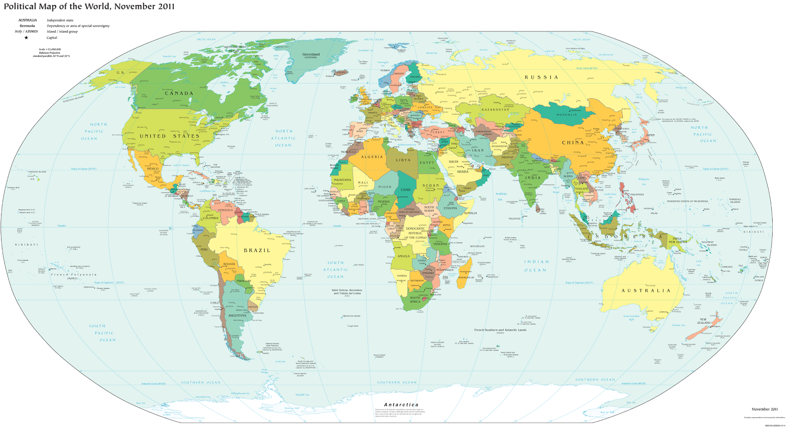
    How many countries in the world?
    A world political map published by the U.S. government (public domain)
    One of the most basic questions for map-lovers is, "How many countries are there in the world?" But anyone who replies with a simple number is leaving out part of the story. The fact is, the answer depends heavily on how you define "country".

    Here are six of the most common answers, each correct in its own way:

    Thursday, December 24, 2015

    War in Iraq: Map of "Islamic State" Control in December 2015 (Subscription)

    MEMBERS CLICK HERE TO PROCEED TO ARTICLE AND MAP

    There are newer versions of this map available. To see them, view all Iraq updates.

    Detailed map of territorial control in Iraq as of December 23, 2015, including territory held by the so-called Islamic State (ISIS, ISIL), the Baghdad government, and the Kurdistan Peshmerga. Includes recent flashpoints including Ramadi, Baiji, Sinjar, and the Kirkuk-Daquq area.
    Subscribe for full access to all conflict map reports!

       Download PDF:
    Buy now
    Research and timeline by Djordje Djukic; map and additional reporting by Evan Centanni

    Though Iraq's current war has been proceeding at a less-intense pace than Syria's, there have been several important changes to territorial control in the past half a year, all involving the so-called "Islamic State" (ISIS) losing ground to the Iraqi government and Kurdistan's Peshmerga force.

    See all this and more on the newest update to PolGeoNow's concise, professional-quality Iraq control map, which includes a timeline of changes since our previous Iraq map report in July.

    This map and report are professional subscriber content, accessible to paid members or by separate purchase. Download PDF (US$19.99)

    Want to see before you buy? Check out our most recent FREE SAMPLE Iraq map report!

    Exclusive map report includes:
    • Up-to-date map of current territorial control in Iraq, color-coded for the Iraqi government, "Islamic State" (ISIS/ISIL) extremists, and Kurdistan's Peshmerga forces
    • Detailed indication of town-by-town control, including provincial boundaries, all major cities, and many smaller ones
    • Markers for key areas of recent fighting such as Ramadi, Baiji, Sinjar, and more
    • Timeline of changes to the situation since July, compiled by our Iraq specialist, with links to sources 
    Note: Republishing rights are not included with PDF purchases or basic subscriptions. If you need to use one of our maps in print or online, contact service@polgeonow.com.

    MEMBERS CLICK HERE TO PROCEED TO ARTICLE AND MAP

    Not a member yet? Click here to learn more about our professional subscription service!

    Thursday, December 10, 2015

    Map: Kazakhstan Joins WTO

    Premium members click here to view this article in the ad-free members area. Not a member yet? Learn about our subscription service!

    Map of World Trade Organization (WTO) member and observer countries, updated for December 2015 to include new member Kazakhstan
    Member and observer states of the World Trade Organization (WTO). Map by Evan Centanni, starting from public domain blank map (license: CC BY-NC-SA).