Saturday, February 2, 2013

Mali Conflict Map: French Take Kidal, Other Towns (February 2013)

There are newer versions of this map available. To see them, view all Mali maps.  


This is an update of our Mali conflict map - for the original story, see Mali Map: Islamist Control & French Intervention.

Updated map of fighting and territorial control in Mali during the January-February 2013 French intervention against the Islamist extremist rebel groups Ansar Dine and MUJAO. Reflects the situation as of February 2, when Kidal and other towns have been captured by French and African forces.
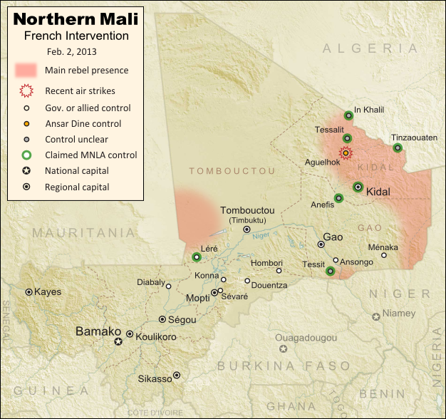
Updated map of territorial control and airstrikes in Mali, as of Feb. 2, 2013. Map by Evan Centanni, modified from Wikimedia map by Orionist, using images by Carport and NordNordWest (source). License: CC BY-SA.
French Troops Secure Kidal
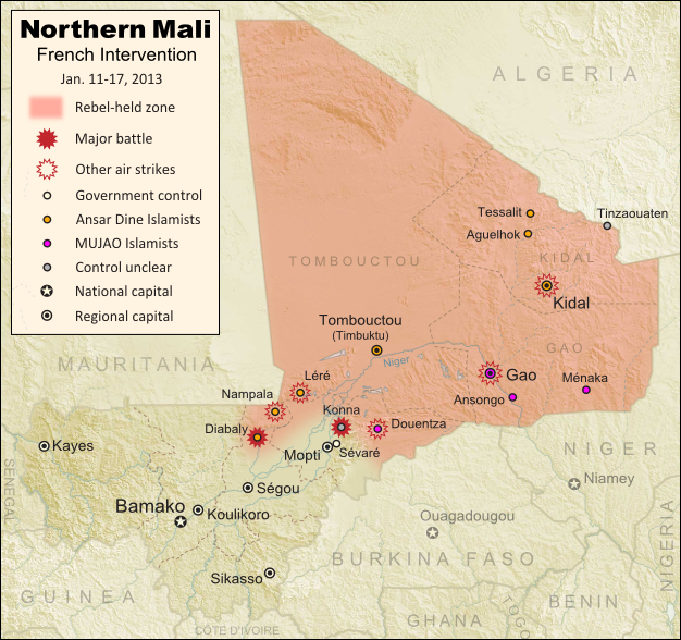
After taking the two largest cities in Mali's north over the last week, the French military by Thursday had also secured Kidal, the last of the area's three major regional centers. The religious extremist rebels of Ansar Dine had apparently already fled the city, which was instead occupied by two moderate rebel organizations, the MIA and the MNLA, the latter of which originally took over the north last spring before being driven out by religious extremist groups.

Sunday, January 27, 2013

Mali Conflict Map: Gao and Timbuktu Retaken (January 2013)

There are newer versions of this map available. To see them, view all Mali maps.   

This is an update of our Mali conflict map - for the original story, see Mali Map: Islamist Control & French Intervention.

Updated map of fighting and territorial control in Mali during the January 2013 French intervention against the Islamist forces of Ansar Dine and MUJAO. Reflects the Jan. 26-27 recapture of major northern cities Gao and Timbuktu by French and Malian forces.
Updated map of territorial control and fighting in Mali, as of Jan. 27, 2013. Map by Evan Centanni, modified from Wikimedia map by Orionist, using images by Carport and NordNordWest (source). License: CC BY-SA.
French-Malian troops capture two major northern cities
Events have proceeded quickly in Mali's ongoing war since the France's military intervention against radical Islamist rebels began just over two weeks ago. This weekend, French and Malian troops recaptured Gao and Timbuktu, two of the three major towns seized by separatist rebels last spring and taken over by radical right-wing militias a few months later.

Tuesday, January 22, 2013

Mali Conflict Map: Douentza Secured by Government (January 2013)

There are newer versions of this map available. To see them, view all Mali maps.   

This is an update of last week's Mali conflict map - for the full story, see Mali Map: Islamist Control & French Intervention.

Updated map of fighting and territorial control in Mali during the January 2013 French intervention against the Islamist forces of Ansar Dine and MUJAO. Reflects the Jan. 21 recapture of central town Douentza by French and Malian forces.
Updated map of territorial control and fighting in Mali, as of Jan. 22, 2013. Map by Evan Centanni, modified from Wikimedia map by Orionist, using images by Carport and NordNordWest (source). License: CC BY-SA.
Key Central Town under French-Malian control
The ongoing French-led war against right-wing Islamic insurgents in northern Mali has achieved another victory. Douentza, probably the most important of the central Malian towns formerly held by the rebels, has now been secured by government and French forces. The allied troops reportedly found that the rebels had already left ahead of them, presumably fleeing the French airstrikes that targeted the town over the last week.

Friday, January 18, 2013

Mali Conflict Map: Hardline Rebels Lose Two Towns (January 2013)

There are newer versions of this map available. To see them, view all Mali maps.   

This is an update of yesterday's Mali conflict map - for the full story, see Mali Map: Islamist Control & French Intervention.

Updated map of fighting and territorial control in Mali during the January 2013 French intervention against the Islamist forces of Ansar Dine and MUJAO. Reflects the Jan. 18 recapture of Konna and Diabaly towns by French and Malian forces.
Updated map of territorial control and fighting in Mali, as of Jan. 18, 2013. Map by Evan Centanni, modified from Wikimedia map by Orionist, using images by Carport and NordNordWest (source). License: CC BY-SA.
Rebels Lose 2 Towns to French-Malian Forces
The French intervention in Mali has finally resulted in territorial gains for the government, after the two central towns of Konna and Diabaly were reportedly retaken by French and Malian troops today. Mali had incorrectly claimed the recapture of Konna earlier this week, and Diabaly was actually seized by the Islamic extremist rebels after French forces arrived. Local sources have now confirmed both towns to be under government control.

Also today, troops from a Nigerian-led West African force finally began arriving in the country (though they have not yet joined in the combat). Meanwhile, a hostage crisis continued into its third day in neighboring Algeria, where militants closely linked to Al Qaeda have taken over a natural gas field and captured its crew of international workers. By some accounts the militants have demanded an end to the French intervention in Mali, though the location of the gas field is far from Mali's borders, and they are believed to have attacked from within Algeria.

Full Story: Mali Map: Islamist Control & French Intervention

Thursday, January 17, 2013

Mali Conflict Map: France Begins Intervention Against Religious Hardline Rebels (January 2013)

There are newer versions of this map available. To see them, view all Mali maps.   

Islamic extremist militants have ruled Mali's vast northern region almost unopposed for half a year, after driving out the secular Tuareg-majority separatists who briefly declared an independent country there last spring. But everything changed last weekend, with a new rebel offensive and surprise French military intervention that have kicked the war back into full gear. Read on for a summary of events.

Map of fighting and territorial control in Mali during the January 2013 French intervention against the Islamist forces of Ansar Dine and MUJAO
Current territorial control and fighting in Mali (including French intervention). Map by Evan Centanni, modified from Wikimedia map by Orionist, using images by Carport and NordNordWest (source). License: CC BY-SA.
Map Updates: Check our Mali channel for frequent updates to this map.

Northern Mali in Rebel Hands
The rebellion in northern Mali began as a separatist struggle led by the National Movement for the Liberation of Azawad (MNLA), a secular group of mostly Tuareg ethnicity who last spring successfully seized Mali's north and declared independence as the State of Azawad. But their victory was soon hijacked by Ansar Dine, a hard-line Islamist militia (also led by Tuaregs) that had fought alongside them previously. Ansar Dine was then joined by MUJAO, an Al Qaeda offshoot group, who swiftly expelled the MNLA from the region. (See: Independent Azawad No More: Northern Mali in Islamist Hands)