Friday, June 1, 2012

Syrian Uprising: Update 4

There are newer versions of this map available. To see them, view all Syria updates.

Full Story: See Syria Divided by Armed Conflict

Map of Syria's uprising, marking cities and towns under control of the Free Syrian Army rebels as of June 2, 2012. Includes the site of the recent Houla massacre.
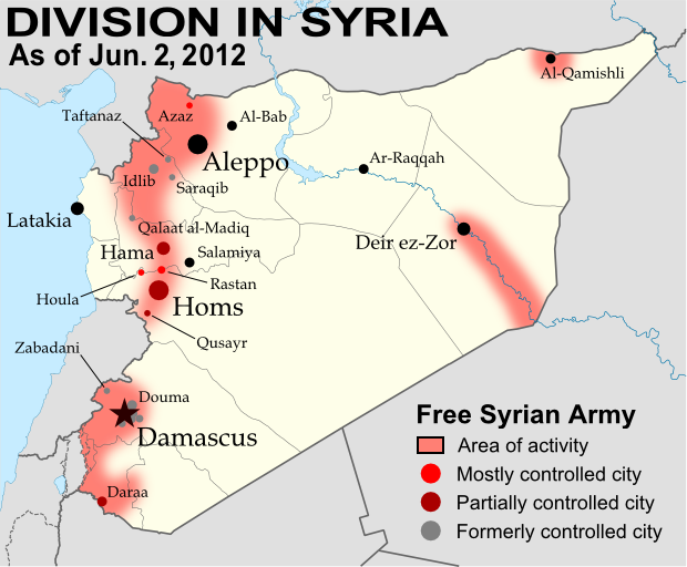
Known areas of armed activity for the rebel "Free Syrian Army" (click to enlarge). My own work, starting from this blank map by NordNordWest. License: CC BY-SA
Wondering what's been going on in Syria since our last map update? There have been few, if any, major changes in territorial control, but here's a brief status update. 

Despite the U.N. brokered ceasefire between the Syrian military and the rebel Free Syrian Army, which was to enter in effect on April 10, armed clashes have continued in many parts of the country, including recent heavy fighting in Rastan. Bloodshed reached a horrific peak a week ago, as over one hundred civilians - nearly half of them children - were massacred in the Houla area of Homs province. Witnesses told the U.N. that the murders were committed by militias loyal to President Assad, though the Syrian government attempted to blame the atrocity on the rebels. In the aftermath, one commander of the Free Syrian Army threatened to call off the ceasefire altogether, which could mean increased fighting in the coming weeks.

Country Name:  
• Syria (English)
• Sūriyya/Sūryā (Arabic)
Official Name:  
• Syrian Arab Republic (English)
• al-Jumhūriyyah al-‘Arabīyah  as-Sūriyyah (Arabic)
Capital: Damascus
Territorial control by the government and rebels has remained mostly the same since April. The only change made to the map is the addition of Houla in red, as at least one source indicates the area was under rebel control both before and after the massacre. Note that the Free Syrian Army is also reported to control much of the northwestern Idlib province outside of the main cities, though the situation is fluid and information is scarce, making it difficult to mark anything definitively on the map. 

Friday, May 25, 2012

Map: Sudan & South Sudan's Disputed Territories

Countries: South Sudan, Sudan
Official Names: Republic of South Sudan, Republic of Sudan
Summary: After South Sudan declared independence from Sudan last year, much of the border between the neighbors is still hotly disputed, with recent violent clashes around the Heglig oil field and other areas. Read on for a full list of Sudan and South Sudan's eight major border flashpoints.

Map of the border between Sudan and South Sudan, marking selected territorial disputes and border clashes in 2012. Includes inset map of April fighting in region of Heglig oil field.
Border map of Sudan and South Sudan, showing disputed areas and fighting since the beginning of 2012. Aerial bombings and attacks by rebel groups not shown. My own work, using blank Sudan and South Sudan maps by NordNordWest / Wikipedia. License: CC BY-SA.


Wednesday, May 2, 2012

Kosovo Recognition Update (Total: 90/193)

Country Name: Kosovo (English, Serbian), Kosova (Albanian)
Official Name: Republic of Kosovo (English), Republika e Kosovës (Albanian),
Republika Kosovo (Serbian)
News Categories: Recognition, Partially Recognized States, Breakaway States
Full Story: See Kosovo Diplomatic Recognition Continues

Map of countries that recognize the Republic of Kosovo as independent
Countries recognizing the Republic of Kosovo in green, with arrows marking the two most recent: São Tomé and Príncipe (left) and Brunei (right). Kosovo in magenta. Modified from public domain wiki map (source).

Tuesday, April 10, 2012

Syrian Uprising: Map Update 3

There are newer versions of this map available. To see them, view all Syria updates.

Country Name: Syria (English), Sūriyya/Sūryā (Arabic)
Official Name: Syrian Arab Republic (English),
al-Jumhūriyyah al-‘Arabīyah as-Sūriyyah (Arabic)
News Category: Divided Countries
Full Story: See Syria Divided by Armed Conflict

Map of Syria, showing control by the rebel Free Syrian Army as of April 10, 2012
Known areas of armed activity for the rebel "Free Syrian Army", marking controlled cities and notable towns.
Many rural areas may also be under full rebel control. Unarmed protests not shown. Map is my own work,
starting from this blank map by German Wikipedia user NordNordWest. License: CC BY-SA

Friday, April 6, 2012

Declaration of Independence of Azawad (English Translation)

Country Name: Azawad (English, Tuareg, French), Azawād (Arabic)
News Categories: New Countries, Breakaway States, Unrecognized States
Full Story: New Country: Azawad Declares Independence from Mali

Flag of Azawad (image by Orionist; source)
Presented here is the full text of the Declaration of Independence of Azawad, originally posted in French to the website of the National Movement for the Liberation of Azawad (MNLA) on April 6, 2012, and translated into English by Evan Centanni of Political Geography Now. The MNLA is a Tuareg-led rebel group which has recently achieved control of the northern part of Mali in West Africa. For a history of the 2012 Tuareg rebellion in Mali, view all Mali posts on Political Geography Now.