Official Name: Republic of Mali (English), République du Mali (French)
News Category: Divided Countries
Summary: Tuareg-led rebels in northern Mali have now completed their control of the region's major cities, after capturing the military headquarters in Gao as well as historic Timbuktu. Meanwhile, Mali has been suspended from regional organization ECOWAS in response to the recent coup d'etat in the capital, Bamako.
 |
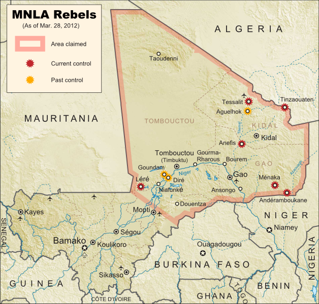
| Towns captured by the Tuareg-majority MNLA rebel group in Mali. Modified from Wikimedia map by Orionist, incorporating images by Carport and NordNordWest (source). License: CC BY-SA. |
Conflict Update
Again immediately following our last update, northern Mali's National Movement for the Liberation of Azawad (MNLA), made up mostly of Saharan Tuareg people, has followed its victory in Kidal by capturing the region's other two major cities. On March 31, the rebels took control of Gao, headquarters of the Malian military in the north, and the next day overran Timbuktu, a historic former trading post and modern tourism destination. The town of Aguelhok in the north is now also being reported as under Tuareg control, though it is unclear when it was recaptured (the rebels had previously taken and lost it again back in January).
The military government of Mali, which took over in a recent coup d'etat, has now withdrawn its forces from most of northern region, known to the Tuareg rebels as Azawad. Neighboring countries have offered military assistance only if the country returns to democracy, and have suspended Mali's membership in the Economic Community of West African States (ECOWAS) while imposing tough sanctions. If help doesn't come soon, the MNLA could be in the position to declare independence in the north, making Azawad Africa's newest country.
Follow events as they develop on Political Geography Now! To see only stories about this ongoing conflict, filter posts using the Mali label.
Seen this map on Wikipedia?
While Political Geography Now sometimes uses free maps from Wikipedia or other sites (after double-checking their sources), we also occasionally post our own maps to Wikipedia and Wikimedia Commons for others to use. The first version of this particular map of the Tuareg-led rebellion in Mali was created for Wikipedia by Orionist, but I have since taken charge of keeping it updated, with a bit of help from Mnmazur on Wikimedia Commons (Mnmazur is not associated with Political Geography Now).


