Showing posts with label resolved territorial disputes. Show all posts

Saturday, July 16, 2022

Nicaragua v. Colombia: World Court Orders Sea Map Adjustments

Map of Colombia's claimed Integral Contiguous Zone around San Andres, Providencia and its other islands in the Caribbean Sea north of Panama and east of Nicaragua, which was one of the main subjects of dispute with Nicaragua in the Nicaragua v. Colombia World Court case that concluded in April 2022 with a judgement from the International Court of Justice (ICJ) in the Hague. At the center of the map is a large purple blob representing the so-called integral contiguous zone, surrounding each island's 12-mile territorial sea and 24-mile normal contiguous zone and filling the gaps between them. Importantly, this integral contiguous zone overlaps the sea border drawn between Colombia and Nicaragua by the ICJ in 2012. Colorblind accessible.
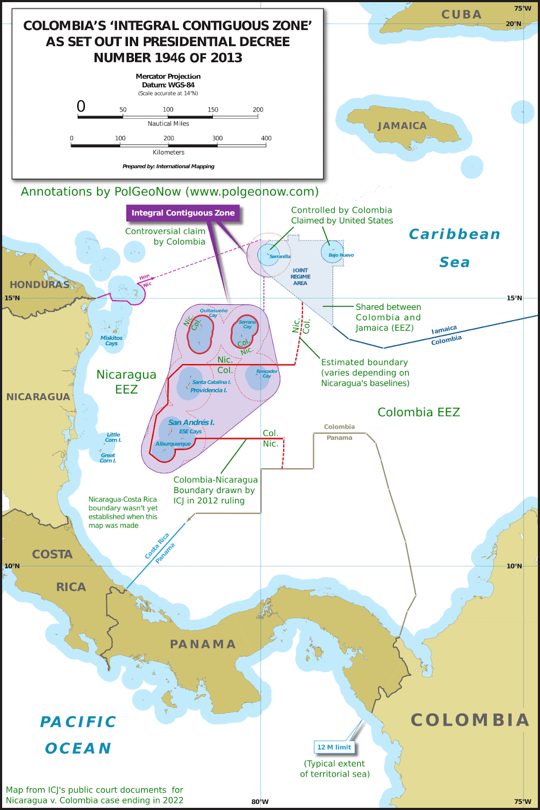
Modified by PolGeoNow from map included in public court documents (original created by International Mapping).

Latest World Court Ruling: Nicaragua v. Colombia Sea Dispute

Judgments handed down by the UN's International Court of Justice (ICJ) - also known by semi-official nickname "the World Court" - can be pretty interesting to political geography nerds like us. Often they establish new land and sea borders or end long-running territorial disputes, as you might have seen in our past coverage of the Burkina Faso/Niger, Peru v. Chile, Costa Rica v. Nicaragua, and Somalia v. Kenya cases.

Wednesday, October 13, 2021

Somalia v. Kenya: 3 Maps Explaining the Maritime Dispute & Court Ruling

Thumbnail image combining the three maps of the Kenya-Somalia maritime dispute, showing the two countries' overlapping territorial sea, EEZ, and continental shelf claims as well as the judgement reached in the ruling of the UN's International Court of Justice (ICJ). The full-size maps are each included separately, with full alternate text, farther down on this page.
Scroll down for the full-size maps

The UN's main court for disputes between countries, the International Court of Justice (ICJ), ruled yesterday on a contentious case many years in the making: Kenya and Somalia's dispute over the rights to a large slice of the Indian Ocean off their coasts.

While other news outlets analyze the politics and economics of the dispute, it's PolGeoNow's job to give you a clearer, more detailed explanation of its geography. And as shown in the three all-new map infographics below, that geography is a bit more complex than most news articles let on.

Scroll down to see each map at full size, along with concise explanations expanding on the information within the graphics...


Saturday, February 3, 2018

Map: Costa Rica & Nicaragua Settle Border Dispute in Court

Conflicto Isla Portillos - mapa 2018. Map of Costa Rica and Nicaragua's post-2015 territorial dispute on Isla Portillos at the mouth of Rio San Juan, showing the judgment of the International Court of Justice (ICJ) of February 2018, based on the case filed in 2017. Includes key features such as Harbor Head Lagoon, the Nicaraguan military camp, the disputed territory along the beach, and the small water channels used to argue Nicaragua's case. Colorblind accessible.
Map by Evan Centanni, based on materials submitted to the court. Contact for usage permissions.

World Court Rules on Costa Rica vs. Nicaragua

What happens when two countries draw their border along a river, then the river changes course? The world got to find out yesterday, as the UN's International Court of Justice (ICJ) released its judgement on a border dispute between Nicaragua and Costa Rica. Though the court's ruling was dominated by a related request to define the two countries' borders at sea, it also involved a tiny sliver of land in a temperamental river delta.

Monday, February 10, 2014

Map: Peru & Chile's Sea Dispute Settled in Court

Two weeks ago, the International Court of Justice released a long-awaited ruling on Peru and Chile's disputed maritime boundary. Many headlines claimed that Peru "won" the case, but in fact it was not a full victory for either country. Below is our detailed map of Peru and Chile's seas and of the dispute, followed by an easy-to-understand summary of the case. 

Map of Chile and Peru's territorial waters and exclusive economic zones (EEZ), plus the details of their territorial dispute at sea and disagreement of the land border. Shows the results of the Jan. 27, 2014 ruling by the International Court of Justice (ICJ) settling the dispute.
Map by Evan Centanni (country coastlines and land borders from Natural Earth)
Premium members click here to view this article in the ad-free members area. Not a member yet? Subscribe now!

Article by Evan Centanni


Disputed Territory
Chile and Peru have just settled a decades-long dispute over the location of their maritime boundary (the border between their sea zones). A large wedge of sea off the countries' coast was claimed by both sides, in part because of its high value for the fishing industry. In 2008, Peru took Chile to court over the dispute. Their disagreements would be resolved by the International Court of Justice (ICJ), a United Nations body in the Hague founded for the purpose of settling differences between U.N. member countries.

Thursday, April 25, 2013

Niger and Burkina Faso Resolve Territorial Dispute

Update: In May 2015, Niger and Burkina Faso formally agreed to implement this ICJ ruling, with the practical aspects of exchanging territories to be completed by the end of the following year.

Map of the disputed territory between Niger and Burkina Faso, which was divided between the two countries in an April 2013 ruling by the International Court of Justice
Map by Evan Centanni. Sources: ICJ, Natural Earth. Africa inset based on this map by TUBS/Wikimedia Commons (CC BY-SA).
By Evan Centanni
 
Border Dispute Settled
Last week, a territorial dispute between the West African countries of Niger and Burkina Faso was resolved peacefully with a ruling from the International Court of Justice (ICJ). Both countries' governments agreed to respect the court's ruling on where their border should lie, a question which had persisted ever since they both achieved independence in 1960.

In the ruling, the court drew an official border based on a careful analysis of a 1927 document establishing the pre-independence boundary between the two former French colonies, also turning to a 1960 French map which both countries had agreed to use as a secondary reference. The new border splits the disputed area between Burkina Faso and Niger, and will help put an end to confusion regarding policing and tax collection in the border area.