Thursday, April 25, 2013

Niger and Burkina Faso Resolve Territorial Dispute

Update: In May 2015, Niger and Burkina Faso formally agreed to implement this ICJ ruling, with the practical aspects of exchanging territories to be completed by the end of the following year.

Map of the disputed territory between Niger and Burkina Faso, which was divided between the two countries in an April 2013 ruling by the International Court of Justice
Map by Evan Centanni. Sources: ICJ, Natural Earth. Africa inset based on this map by TUBS/Wikimedia Commons (CC BY-SA).
By Evan Centanni
 
Border Dispute Settled
Last week, a territorial dispute between the West African countries of Niger and Burkina Faso was resolved peacefully with a ruling from the International Court of Justice (ICJ). Both countries' governments agreed to respect the court's ruling on where their border should lie, a question which had persisted ever since they both achieved independence in 1960.

In the ruling, the court drew an official border based on a careful analysis of a 1927 document establishing the pre-independence boundary between the two former French colonies, also turning to a 1960 French map which both countries had agreed to use as a secondary reference. The new border splits the disputed area between Burkina Faso and Niger, and will help put an end to confusion regarding policing and tax collection in the border area.

Saturday, April 20, 2013

North Kosovo Status Changing After Serbia Deal

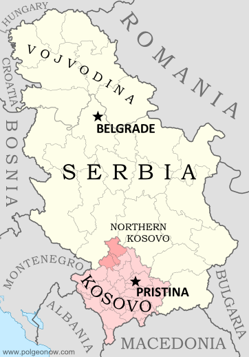
Map of Serbia, Kosovo, and North Kosovo
Map by Evan Centanni, based on these two blank maps by Nord-NordWest. License: CC BY-SA
Kosovo & Serbia in Historic Agreement
Serbia and the breakaway Republic of Kosovo reached a landmark deal on Friday to normalize their relations, partially compromising on several contentious issues between the two governments in southeastern Europe. Kosovo declared its independence from Serbia in 2008, but due to Serbia's opposition it has still not achieved full international recognition. 

Status Change for North Kosovo
North Kosovo is the largest of several areas within Kosovo where the majority of people are part of the Serb ethnic group, whereas 90% of people in Kosovo as a whole are ethnically Albanian. When Kosovo split from Serbia, many Serbs in the north refused to go, governing themselves separately from Kosovo and choosing instead to continue cooperating with and accepting government funding from Serbia.

Thursday, April 11, 2013

What is North Korea?

North Korea's threats of war have captured the world's attention in recent weeks, leaving citizens of other East Asian countries anxiously awaiting the latest news. A new war is unlikely, but how much do you know about North Korea, its international status, and its dispute with the south?

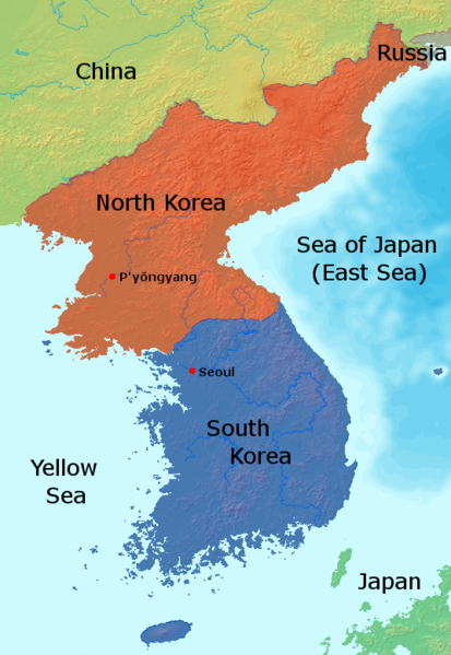
Map of North Korea and South Korea
Map by Johannes Barre & Patrick Mannion (CC BY-SA) (source)
What is North Korea?
Located on the northern half of the Korean Peninsula between South Korea and China (and sharing a short border with Russia), North Korea is a medium-sized East Asian country of about 24 million people. Despite its size, it boasts the fourth-largest army in the world, and has remained officially at war with South Korea since 1950.

Sometimes considered one of the world's last remaining communist states, North Korea actually claims no longer to follow communist ideology. However, it surely does hold the distinction of having the world's most closed borders, with its totalitarian government tightly controlling the flow of information and people in and out of the country.

Friday, April 5, 2013

Kosovo Recognition Update: April 2013 (99/193)

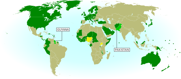
Map of countries that recognize the Republic of Kosovo as an independent state, updated for April 2013 with most recent additions highlighted
Countries recognizing the Republic of Kosovo in green, with the two most recent additions highlighted. Disputed recognitions in yellow. Kosovo in magenta. Map by Evan Centanni, modified from public domain graphic (source).