Saturday, July 16, 2022

Nicaragua v. Colombia: World Court Orders Sea Map Adjustments

Map of Colombia's claimed Integral Contiguous Zone around San Andres, Providencia and its other islands in the Caribbean Sea north of Panama and east of Nicaragua, which was one of the main subjects of dispute with Nicaragua in the Nicaragua v. Colombia World Court case that concluded in April 2022 with a judgement from the International Court of Justice (ICJ) in the Hague. At the center of the map is a large purple blob representing the so-called integral contiguous zone, surrounding each island's 12-mile territorial sea and 24-mile normal contiguous zone and filling the gaps between them. Importantly, this integral contiguous zone overlaps the sea border drawn between Colombia and Nicaragua by the ICJ in 2012. Colorblind accessible.
Modified by PolGeoNow from map included in public court documents (original created by International Mapping).

Latest World Court Ruling: Nicaragua v. Colombia Sea Dispute

Judgments handed down by the UN's International Court of Justice (ICJ) - also known by semi-official nickname "the World Court" - can be pretty interesting to political geography nerds like us. Often they establish new land and sea borders or end long-running territorial disputes, as you might have seen in our past coverage of the Burkina Faso/Niger, Peru v. Chile, Costa Rica v. Nicaragua, and Somalia v. Kenya cases.

Tuesday, July 12, 2022

Ukraine: Map of Russian Control on July 9, 2022 - Luhansk Fully Captured (Subscription)

SUBSCRIBERS CLICK HERE TO VIEW FULL ARTICLE AND MAP:
Old Portal (members.polgeonow.com) | New Portal (controlmaps.polgeonow.com)


There are newer versions of this map available. To see them, view all Ukraine articles on PolGeoNow.

Research by Djordje Djukic. Map by Evan Centanni and Djordje Djukic

Subscribe for full access to all conflict map reports!

Thumbail previewing map of Russian-controlled territory in Ukraine on July 9, 2022). In addition to the Crimean peninsula, which Russia had already seized in 2014, and parts of the far eastern Donetsk and Luhansk provinces (the Donbass region) already controlled by Russia-backed separatist rebels (and declared independent as the Donetsk and Lugansk People's Republics), Russian forces now control a large strip of territory just north of Crimea, including Kherson city and parts of Mariupol, as well as all of Luhansk province and large additional areas of Donetsk and Kharkiv  provinces. Map includes key locations from the news, such as Sievierodonetsk, Lysychansk, Izium, Popasna, Snake Island, and more. Colorblind accessible. In the past month, Russia and its allies from the self-proclaimed Lugansk People's Republic (LPR) have completed their control of the area corresponding to Ukraine's Luhansk province - the first time since 2014 that it hasn't been divided between the Ukrainian government and LPR/Russian control.

See all this and more on the latest update to PolGeoNow's concise, professional Ukraine war control map, which includes a detailed chronicle of changes and events since our previous Ukraine map report of June 13, with sources cited, as well as a close-up map of control within the claimed borders of the Donetsk and Lugansk People's Republics.


This map and report are premium content, available to paid subscribers of the PolGeoNow Conflict Mapping Service.

Want to see before you subscribe? Check out our most recent FREE SAMPLE Ukraine map!

Exclusive map report includes:

  • Up-to-date illustration of current territorial control in Ukraine, color-coded for the Ukrainian government on one side and the Russian military and allied rebels on the other side, with areas of uncertainty indicated. Colorblind accessible.
  • Darker color indicating which areas were already under Russian or allied control before the 2022 invasion began
  • Donbas close-up map
    Close-up map of territorial control within the self-proclaimed borders of the Donetsk People's Republic and Lugansk People's Republic (based on the design of our old map of rebel control in the Donbas)
  • NEW: Donetsk and Lugansk close-up map has been upgraded to include terrain and major rivers and roads
  • Detailed indication of city-by-city control, including key towns and other locations important to current events
  • Locations of recent control changes and other important events, including Sievierodonetsk, Lysychansk, Bilohorivka, Bohorodychne, Snake Island, and more
  • Detailed timeline of important events and changes to territorial control since June 13, 2022, with links to sources.

SUBSCRIBERS CLICK HERE TO VIEW FULL ARTICLE AND MAP:
Old Portal (members.polgeonow.com) | New Portal (controlmaps.polgeonow.com)


Not signed up yet? Click here to learn more about our professional subscription service!

Can I purchase just this map?
This map and report are not available for automated purchase to non-subscribers. If you need access or republication rights for only this map report, contact service@polgeonow.com for options.

Thursday, June 16, 2022

Ukraine: Map of Russian Control on June 13, 2022 (Subscription)

SUBSCRIBERS CLICK HERE TO VIEW FULL ARTICLE AND MAP:
Old Portal (members.polgeonow.com) | New Portal (controlmaps.polgeonow.com)


There are newer versions of this map available. To see them, view all Ukraine articles on PolGeoNow.

Research by Djordje Djukic. Map by Evan Centanni and Djordje Djukic

Subscribe for full access to all conflict map reports!

Thumbail previwing map of Russian-controlled territory in Ukraine on June 13, 2022). In addition to the Crimean peninsula, which Russia had already seized in 2014, and parts of the far eastern Donetsk and Luhansk provinces (the Donbass region) already controlled by Russia-backed separatist rebels (and declared independent as the Donetsk and Lugansk People's Republics), Russian forces control a large strip of territory just north of Crimea, including Kherson city and parts of Mariupol, as well as large additional areas of Donetsk and Luhansk, and other areas of Ukraine's northeast. Ukrainian capital city Kyiv (Kiev) is no longer under siege. Map includes key locations from the news, such as Ternova, Sviatohirsk, Davydiv Brid, the Azot chemical plant in Sievierodonetsk, and more. Colorblind accessible. In recent weeks, Russia and its allies in Donetsk and Luhansk have maintained the upper hand in their fight against Ukraine's government, defending most of the frontlines and nearly completing the capture of Sievierodonetsk, the biggest remaining Ukraine-held city claimed by the self-declared Lugansk People's Republic. 

This update also sees the return of our old map of rebel control in eastern Ukraine, re-imagined as a close-up illustration of remaining Ukrainian control within the claimed borders of the self-proclaimed Donetsk and Lugansk People's Republics.

See all this and more on the latest update to PolGeoNow's concise, professional Ukraine war control map, which includes a timeline of changes since our previous Ukraine map report of May 19, with sources cited.


This map and report are premium content, available to paid subscribers of the PolGeoNow Conflict Mapping Service.

Want to see before you subscribe? Check out our most recent FREE SAMPLE Ukraine map!

Exclusive map report includes:

  • Up-to-date illustration of current territorial control in Ukraine, color-coded for the Ukrainian government on one side and the Russian military and allied rebels on the other side, with areas of uncertainty indicated. Colorblind accessible.
  • Darker color indicating which areas were already under Russian or allied control before the 2022 invasion began
  • NEW: Close-up map of territorial control within the self-proclaimed borders of the Donetsk People's Republic and Lugansk People's Republic (based on the design of our old map of rebel control in the Donbas)
  • Detailed indication of city-by-city control, including key towns and other locations important to current events
  • Locations of recent control changes and other important events, including Ternova, Sviatohirsk, Davydiv Brid, the Azot chemical plant in Sievierodonetsk, and more
  • Detailed timeline of important events and changes to territorial control since May 19, 2022, with links to sources.

SUBSCRIBERS CLICK HERE TO VIEW FULL ARTICLE AND MAP:
Old Portal (members.polgeonow.com) | New Portal (controlmaps.polgeonow.com)


Not signed up yet? Click here to learn more about our professional subscription service!

Can I purchase just this map?
This map and report are not available for automated purchase to non-subscribers. If you need access or republication rights for only this map report, contact service@polgeonow.com for options.

Friday, June 10, 2022

Central African Republic Control Map & Timeline - May 2022 (Subscription)

SUBSCRIBERS CLICK HERE TO VIEW FULL ARTICLE AND MAP:
Old Portal (members.polgeonow.com) | New Portal (controlmaps.polgeonow.com)


(To see other maps of this conflict, view all Central African Republic articles on PolGeoNow.) 

Research by Djordje Djukic, with additional reporting by Evan Centanni. Map by Evan Centanni and Djordje Djukic

Subscribe for full access to all conflict map reports!

Thumbnail preview of Central African Republic conflict: 2021 map of rebel and government control. Updated to June 5, 2022, showing territorial control by the CAR government (with Russian Wagner Group mercenaries and the UN's MINUSCA peacekeeping force), CPC rebel coalition (FPRC, UPC, MPC, 3R),  other ex-Séléka rebels (RPRC, MLCJ), Anti-balaka militias, and other armed groups such as Joseph Kony's Lord's Resistance Army (LRA). Colorblind accessible.

Pro-government forces led by the Russian Wagner Group have accelerated their campaigns in the eastern CAR, carving out new chains of government-held towns deep inside the once-rebel-dominated northeast. Meanwhile, the UPC, perhaps the country's most powerful rebel faction, has rejoined the larger anti-government coalition.

See all this and more on the latest update to PolGeoNow's concise, professional CAR control map, which includes a timeline of changes since our previous CAR map report of July 2021, with sources cited.


This map and report are premium content, available to paid subscribers of the PolGeoNow Conflict Mapping Service.

Want to see before you subscribe? Check out our most recent FREE SAMPLE Central African Republic control map!

Exclusive map report includes:

  • Up-to-date illustration of current territorial control in the Central African Republic, color-coded for the government and allies, the CPC rebel coalition, "Anti-balaka" militias, and other rebel groups, with areas of uncertainty indicated. Colorblind accessible.
  • Detailed indication of city-by-city control, including key towns and other locations important to current events
  • Locations of recent control changes and other important events, including Tiringoulou, Ouanda Djallé, Nzakoundou, Nzacko, Kaita, and more
  • Detailed timeline of important events and changes to territorial control since July 15, 2022, with links to sources.

SUBSCRIBERS CLICK HERE TO VIEW FULL ARTICLE AND MAP:
Old Portal (members.polgeonow.com) | New Portal (controlmaps.polgeonow.com)


Not signed up yet? Click here to learn more about our professional subscription service!

Can I purchase just this map?
This map and report are not available for automated purchase to non-subscribers. If you need access or republication rights for only this map report, contact service@polgeonow.com for options.
Friday, May 20, 2022

Ukraine: Map of Russian Control on May 19, 2022 (Subscription)

SUBSCRIBERS CLICK HERE TO PROCEED TO ARTICLE AND MAP

There are newer versions of this map available. To see them, view all Ukraine articles on PolGeoNow.

Research by Djordje Djukic. Map by Evan Centanni and Djordje Djukic

Subscribe for full access to all conflict map reports!

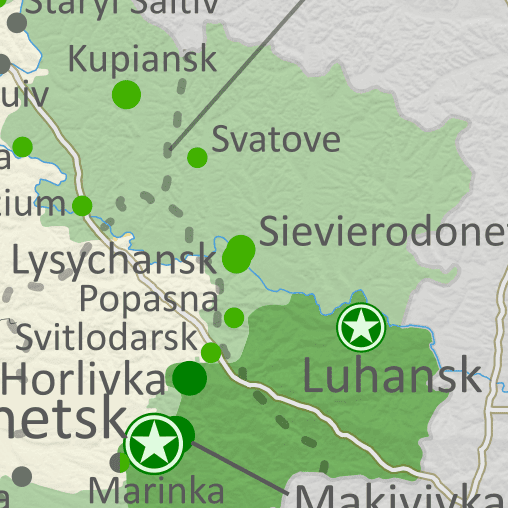
Map of Russian-controlled territory in Ukraine almost three months into the Russian invasion (May 19, 2022). In addition to the Crimean peninsula, which Russia had already seized in 2014, and parts of the far eastern Donetsk and Luhansk provinces (the Donbass region) already controlled by Russia-backed separatist rebels (and declared independent as the Donetsk and Lugansk People's Republics), Russian forces control a large strip of territory just north of Crimea, including Kherson city and parts of Mariupol, as well as large additional areas of Donetsk and Luhansk, and other areas of Ukraine's northeast. Ukrainian capital city Kyiv (Kiev) is no longer under siege. Map includes key locations from the news, such as Popasna, Rubizhne, Bilohorivka, Staryi Saltiv, the Azovstal steel plant in Mariupol, and more. Colorblind accessible. Russia-led forces have nearly surrounded the last Ukraine-held city in Luhansk after capturing two long-contested towns nearby, and have just about completed their control of Mariupol. On the other hand, Ukrainian forces have ended the siege of Kharkiv city in the north, driving Russian forces back towards the border there.

See all this and more on the latest update to PolGeoNow's concise, professional Ukraine war control map, which includes a timeline of changes since our previous Ukraine map report of May 4, with sources cited.


This map and report are premium content, available to paid subscribers of the PolGeoNow Conflict Mapping Service.

Want to see before you subscribe? Check out our most recent FREE SAMPLE Ukraine map!

Exclusive map report includes:

  • Up-to-date illustration of current territorial control in Ukraine, color-coded for the Ukrainian government on one side and the Russian military and allied rebels on the other side, with areas of uncertainty indicated. Colorblind accessible.
  • Darker color indicating which areas were already under Russian or allied control before the 2022 invasion began
  • Claimed borders of the Russia-backed, self-proclaimed Donetsk People's Republic and Lugansk People's Republic in the eastern Donbass region.
  • Detailed indication of city-by-city control, including key towns and other locations important to current events
  • Locations of recent control changes and other important events, including Popasna, Rubizhne, Bilohorivka, Staryi Saltiv, the Azovstal steel plant in Mariupol, and more
  • Detailed timeline of important events and changes to territorial control since May 4, 2022, with links to sources.

SUBSCRIBERS CLICK HERE TO PROCEED TO ARTICLE AND MAP

Not signed up yet? Click here to learn more about our professional subscription service!

Can I purchase just this map?
This map and report are not available for automated purchase to non-subscribers. If you need access or republication rights for only this map report, contact service@polgeonow.com for options.