Friday, June 4, 2021

African Union Suspends Mali Again (Map)

Correction (Sep. 2023): It's since come to our attention that South Sudan's suspension had already been lifted at the time this article was published. For details, see our September 2023 African Union map update. The text of this article has now been corrected, but the map has not.

African Union: Map of Africa showing which countries are suspended from the African Union in June 2021, as well as which countries are active members and which territories aren't part of the union. Updated for the June 2021 suspension of Mali, the country's third time being suspended, and its second time in less than a year (colorblind accessible).
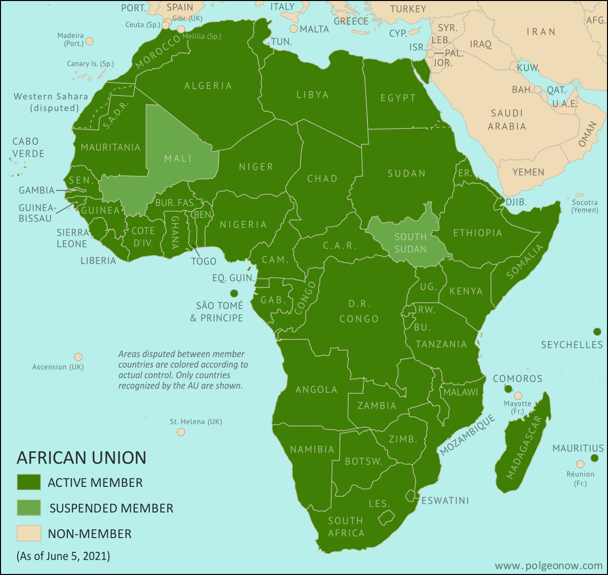
Map by Evan Centanni, from blank map by Eric Gaba. License: CC BY-SA

Mali Suspended from AU for Second Time in Less Than a Year

PolGeoNow readers may remember that Mali was suspended from membership in the African Union (AU) last August, after a military faction overthrew the country's government. That suspension was reversed in October, when a civilian transitional government came to power. But with military figures once again taking over the country late last month, the AU has once again suspended Mali's membership. The new suspension was imposed on June 6.

Friday, May 14, 2021

Israel / Palestine Map: Who Controlled What in May 2021?

This is the 2021 edition of our Israel/Palestine control map, first published in July 2020. A newer version is now available.

Map of who controls Palestine and Israel's claimed territories today (May 14, 2021), as Gaza Strip violence continues to escalate? Israeli and Palestinian Authority administration (Fatah and Hamas factions indicated separately). Also file under: Palestine controlled area map. Includes bigger West Bank map (Areas A, B, C). Map also includes Gaza Strip, Golan Heights, major cities and Israeli settlements, UN peacekeeper deployments (UNIFIL and UNDOF), no man's land, Golan Heights buffer zone (area of separation, AOS), and Shebaa Farms. Colorblind accessible.
Click to enlarge. Map by Evan Centanni, incorporating base map by Koen Adams of onestopmap.com and data from B'Tselem's interactive mapping project. (Contact us for permission to use this map.)

Israel and Palestine Controlled Areas in 2021

The Israeli government's much-hyped plan to absorb parts of the Palestine-claimed West Bank into Israel in 2020 didn't happen (at least not yet). But in May 2021, the region was once again making headlines amid a new wave of fighting. So who actually controlled what parts of Palestine and Israel's claimed territories at the time? This revised version of PolGeoNow's Israel/Palestine control map lays out the details of government jurisdictions on the ground.

There were no changes to the lines of control between 2020 and this 2021 edition, but this edition of the map did feature several modifications for improved clarity and more precise depictions of the situation. If you see something you don't understand on the map, check out the latest edition of our concise outline explaining who's who and introducing each of the disputed areas.

Note that this is a map of who actually controls what, not of who claims which areas. And it's definitely not supposed to imply that any particular party should or shouldn't control any particular area. As always, PolGeoNow takes no side in these disputes, and we have done our best to report only the facts.

Newer Map and Explainer Article: Who Controls What in the Israel-Palestine conflict?

Saturday, May 8, 2021

Yemen Control Map & Report: Houthis at Marib's Doorstep - May 2021 (Subscription)

SUBSCRIBERS CLICK HERE TO PROCEED TO ARTICLE AND MAP

There are newer versions of this map available. To see them, view all Yemen articles on PolGeoNow.

Timeline by Djordje Djukic. Map by Evan Centanni, Djordje Djukic, and onestopmap.com

Map of what's happening in Yemen as of May 2021, including territorial control for the unrecognized Houthi government, president-in-exile Hadi and his allies in the Saudi-led coalition, the UAE-backed southern separatist Southern Transitional Council (STC), and Al Qaeda in the Arabian Peninsula (AQAP). Includes recent locations of fighting and other events, including Marib, Al-Sadd Lake, Kassara, Rahida, and more.
Subscribe for full access to all conflict map reports!

Yemen's Houthis have come within just a few kilometers of Marib, the last major northern stronghold of the internationally-recognized Hadi government. Meanwhile, Hadi's forces are still fighting the Houthis in the southwest too, but their ceasefire with southern separatists has continued to hold.

See all this and more on the newest update to PolGeoNow's Yemen territorial control map, which includes a timeline of changes and important events since our previous Yemen map report in February.

This map and report are premium content available to paid subscribers of the PolGeoNow Conflict Mapping Service.

Want to see before you buy? Check out our most recent FREE SAMPLE Yemen map report!

Exclusive report includes:
  • Up-to-date map of current territorial control in Yemen, color-coded for the pro-Hadi coalition, the separatist Southern Transitional Council (STC), Houthi forces, and Al Qaeda in the Arabian Peninsula (AQAP)
  • Detailed indication of town-by-town control, including provincial boundaries, all major cities, and many smaller ones
  • Markers for recent areas of fighting, including Marib, Al-Sadd Lake, Kassara, Rahida, and more
  • Timeline of changes to the situation since March 24, 2021, with links to sources 

SUBSCRIBERS CLICK HERE TO PROCEED TO ARTICLE AND MAP

Not a member yet? Click here to learn more about our professional subscription service!

Can I purchase just this map?
This map and report are not available for automated purchase to non-subscribers. If you need access or republication rights for only this map report, contact service@polgeonow.com for options.

Wednesday, April 28, 2021

Libya Control Map & Timeline: Lines Frozen by Unity Deal - April 2021 (Subscription)

SUBSCRIBERS CLICK HERE TO PROCEED TO ARTICLE AND MAP

(To see more maps in this series, view all Libya articles.)

Research by Djordje Djukic. Map by onestopmap.com, Evan Centanni, and Djordje Djukic.

Subscribe for full access to all conflict map reports!

Libya: Who controls what? A concise, professional map of who controls Libya now (April 2021). Shows detailed territorial control in the aftermath of the Libyan Civil War as of April 26, 2021, including all major parties (forces aligned with the former Government of National Accord (GNA); General Haftar's eastern-based Libyan National Army (LNA) and allies; Tuareg and Toubou (Tebu, Tubu) militias in the south; and the so-called Islamic State (ISIS/ISIL)). Includes terrain, major roads, and recent locations of interest including Ghadames, Ubari, Sirte, Sidra, and more. Colorblind accessible.Libya's civil war entered a stalemate after the eastern government's failure to capture Tripoli from the western government last year - and now it's been tentatively declared over after a peace deal and formation of a unity government. 

But for the time being, the lines of control between former opposing military forces remain in place, and we've made some adjustments to the map based on newly-available information.

See all this and more on the latest update to PolGeoNow's concise, professional Libya control map, which comes with a timeline of changes since our previous Libya control map report of June 21, 2020.

This map and report are premium content available to paid subscribers of the PolGeoNow Conflict Mapping Service.

Want to see before you subscribe? Check out our most recent FREE SAMPLE Libya map!

Exclusive report includes:

  • Up-to-date map of current territorial control in Libya, color-coded for forces aligned with the former Government of National Accord (GNA), Khalifa Haftar's Libyan National Army (LNA), the so-called "Islamic State" (ISIS/ISIL), and Toubou and Tuareg militias in the south. Colorblind accessible.
  • Detailed indication of city-by-city control, including key towns and other locations important to current events.
  • Detailed timeline of important events and changes to territorial control since June 21, 2020, with links to sources.

SUBSCRIBERS CLICK HERE TO PROCEED TO ARTICLE AND MAP

Not signed up yet? Click here to learn more about our professional subscription service!

Can I purchase just this map?
This map and report are not available for automated purchase to non-subscribers. If you need access or republication rights for only this map report, please contact service@polgeonow.com for options.

Thursday, April 22, 2021

Mozambique Insurgency: Close-up Map of Control in April 2021

There are newer editions of this map available. To see them, view all Mozambique articles on PolGeoNow.

It's finally here: the close-up, super-detailed version of our Mozambique insurgency control map! This edition depicts the situation near the beginning of this month, when the government was fighting for control of Palma. A new close-up version of our August 2020 map is also now available, and future updates are expected more frequently from now on. To see the full list of reports, you can always view all Mozambique articles on PolGeoNow.

Mozambique: Cabo Delgado conflict map - April 2021: Detailed, close-up control map showing areas occupied by so-called ISIS-linked rebels in northern Mozambique (also known as Ahlu Sunnah Wa Jama, ASWJ, Ansar al-Sunnah, or Al Shabaab), plus towns and villages raided by the insurgents over the past eight months. Shows roads, rivers, and terrain, and includes key locations of the insurgency such as Palma, Mocímboa da Praia, Awasse, Macomia, the Total LNG site and natural gas fields, Muidumbe, Pangane, Muatide, Vamizi Island, and many more towns and villages. Key locations across the border in Tanzania also shown. Updated to April 2, 2021. Colorblind accessible.
Map by Evan Centanni and Djordje Djukic. Some elements © OpenStreetMap contributors. Terrain data sourced from ViewFinderPanoramas. Contact us for permission to use this map.

(Subscribers click here to view this article in the member area)

Timeline by Djordje Djukic and Evan Centanni

New: Close-up Cabo Delgado Insurgency Map

In the eight months since our first Mozambique conflict timeline was published, insurgents in Cabo Delgado province have gradually increased their control, continuing to raid villages and towns in multiple districts, culminating most recently in their temporary takeover of most of Palma, a major town close to under-construction natural gas facilities operated by French company Total. The rebel group - locally known as "Al Shabaab" but thought to formally label itself Ahlu Sunnah Wa-Jamâ (ASWJ) - is increasingly believed to be cooperating, if only loosely, with the so-called "Islamic State" (IS; ISIS/ISIL).

Now, for the first time, PolGeoNow presents our close-up map of the Cabo Delgado conflict, rigorously researched and edited to provide the most detailed, informative, and reliable map of insurgent control and attacks available anywhere.