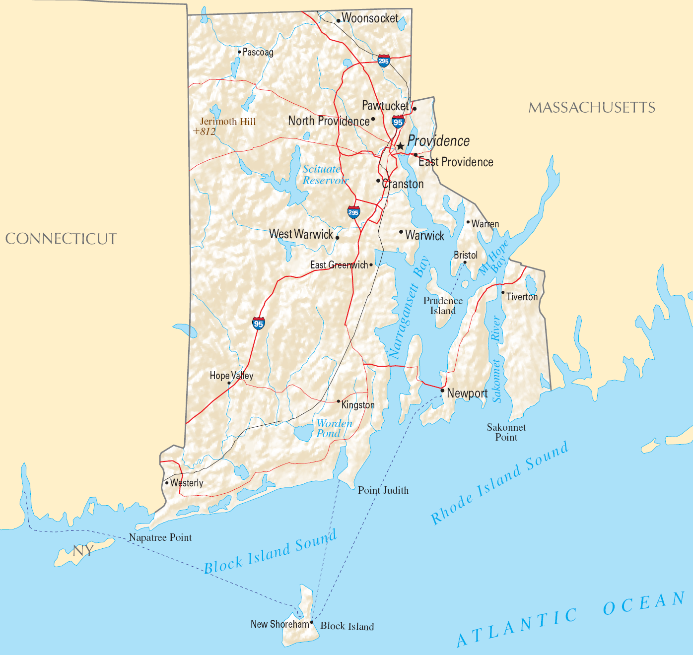
Friday, January 22, 2021

USA: Rhode Island State's Name Change

Map of the State of Rhode Island - formerly the State of Rhode Island and Providence Plantations - from the United States National Atlas
State of Rhode Island and Providence Plantations. The island hosting Newport (lower right) is the original "Rhode Island", while "Providence Plantations" referred to the mainland area around Providence (top right). (Public domain map)

Rhode Island Name Change Now in Effect

Tiny Rhode Island has become the first of the 50 US states ever to change its name.

Even many Americans don't realize that Rhode Island, the smallest US state by area, actually had a longer official name until last year: State of Rhode Island and Providence Plantations. 

But in a referendum on Nov. 3, the same day as the 2020 US presidential election, the state's voters chose to amend the state constitution and shorten the name to just "State of Rhode Island". 

Monday, December 28, 2020

Yemen Control Map & Report - December 2020 (Subscription)

SUBSCRIBERS CLICK HERE TO PROCEED TO ARTICLE AND MAP

There are newer versions of this map available. To see them, view all Yemen articles on PolGeoNow.

Timeline by Djordje Djukic. Map by Evan Centanni, Djordje Djukic, and onestopmap.com

Map of what's happening in Yemen as of December 2020, including territorial control for the unrecognized Houthi government, president-in-exile Hadi and his allies in the Saudi-led coalition, the UAE-backed southern separatist Southern Transitional Council (STC), and Al Qaeda in the Arabian Peninsula (AQAP). Includes recent locations of fighting and other events, including Maas base, Lawdar, Al-Uqlah, Zinjibar, and more.
Subscribe for full access to all conflict map reports!

In the past two months, Yemen's Houthis have continued to gain ground against both the Hadi government and Al Qaeda, while the separatist conflict in the south moves closer to a possible resolution.

See all this and more on the newest update to PolGeoNow's Yemen territorial control map, which includes a timeline of changes and important events since our previous Yemen map report in October.

This map and report are premium content available to paid subscribers of the PolGeoNow Conflict Mapping Service.

Want to see before you buy? Check out our most recent FREE SAMPLE Yemen map report!

Exclusive report includes:
  • Up-to-date map of current territorial control in Yemen, color-coded for the pro-Hadi coalition, the separatist Southern Transitional Council (STC), Houthi forces, and Al Qaeda in the Arabian Peninsula (AQAP)
  • Detailed indication of town-by-town control, including provincial boundaries, all major cities, and many smaller ones
  • Markers for recent areas of fighting, including Maas base, Lawdar, Al Uqlah, Zinjibar, and more
  • Timeline of changes to the situation since October 30, 2020, with links to sources 

SUBSCRIBERS CLICK HERE TO PROCEED TO ARTICLE AND MAP

Not a member yet? Click here to learn more about our professional subscription service!

Can I purchase just this map?
This map and report are not available for automated purchase to non-subscribers. If you need access or republication rights for only this map report, contact service@polgeonow.com for options.

Tuesday, December 1, 2020

Nagorno-Karabakh Control Map & Timeline: Artsakh Withdrawals - December 1, 2020

There are newer versions of this map available. To see them, view all Nagorno-Karabakh articles on PolGeoNow.

This update on the (approximate) final results of the 2020 Azerbaijan-Armenia war is free for all readers.

Nagorno-Karabakh control map, showing territorial claims and control after the Azerbaijan-Armenia war, including the self-proclaimed Republic of Artsakh. Updated to December 1, 2020, at the approximate time of completion of all Artsakh/Armenian withdrawals promised under the 2020 peace agreement. Colorblind accessible.
Map of current territorial control. By Evan Centanni and Djordje Djukic, starting from this map by
Bourrichon and Lesqual. License: CC BY-SA
 
 
Timeline by Djordje Djukic
 

Artsakh/Armenian Forces Make Promised Withdrawals

Map of territorial change in Nagorno-Karabakh before and after the 2020 war between Azerbaijan and the Armenia-backed, self-proclaimed Republic of Artsakh. Updated to December 1, 2020, the date of approximate completion of the Artsakh/Armenia withdrawals from areas outside the NKAO. Colorblind accessible.
Click to enlarge: Map of territorial changes during and after the war
(For credit and license see main map above)

Three weeks after the peace deal that brought an end to the 2020 war between Azerbaijan and the Armenia-backed, self-proclaimed Republic of Artsakh, the latter side has completed the additional withdrawals it promised in the deal.

Though no official map has yet been released of the new lines of control, PolGeoNow has estimated their course based on news reporting and a comparison between information reported by various other online mapping projects.

Saturday, November 28, 2020

RCEP: Agreement Signed to Form Massive Free Trade Area (Map)

Globe-style map of which countries have signed the RCEP (Regional Comrehensive Economic Partnership) agreement (colorblind accessible).


Graphic modified by Evan Centanni from this map by Wikimedia user Masterdeis (CC BY-SA).

What is the RCEP free trade deal?

Two weeks agao, 15 countries in Asia and Oceania signed a long-planned treaty to form the Regional Comprehensive Economic Partnership (RCEP), a free trade area widely billed as the "world's largest". However, the RCEP doesn't exist quite yet as an actual free trade area, since it's still waiting to be ratified (written into the laws of member countries). Read on for a quick explanation of what the RCEP is, when it will be implemented, and how it compares to the world's other free trade areas.

Monday, November 23, 2020

Syria Control Map & Report: Army Takes Last IS Stronghold - November 2020 (Subscription)

SUBSCRIBERS CLICK HERE TO PROCEED TO ARTICLE AND MAP

There are newer versions of this map available. To see them, view all Syria updates.

Research by Djordje Djukic. Map by onestopmap.com, Evan Centanni, and Djordje Djukic

Subscribe for full access to all conflict map reports!

Syrian Civil War map: Territorial control in Syria in late November 2020 (Free Syrian Army rebels, Kurdish YPG, Syrian Democratic Forces (SDF), Hayat Tahrir al-Sham (HTS / Al-Nusra Front), and others). Includes areas of dispersed operational presence for so-called Islamic State (ISIS/ISIL), Turkish/TFSA control, joint SDF-Assad control, US deconfliction zone, and Turkey-Russia security corridor, plus recent locations of conflict and territorial control changes, including Doubayat gas field, Al Karak, Morek, and more. Colorblind accessible. The so-called "Islamic State" (ISIS/ISIL) has lost control of a remote gas field that formed its last clearly-held territory in Syria. But it hasn't disappeared: The group has continued carrying out attacks in the central desert through a dispersed, mobile operations network.

See all this and more on the latest update to PolGeoNow's concise, professional Syrian Civil War control map, which includes a timeline of changes since our previous Syria map report in July, with sources cited.

This map and report are premium content, available to paid subscribers of the PolGeoNow Conflict Mapping Service.

Want to see before you subscribe? Check out our most recent FREE SAMPLE Syria map!

Exclusive map report includes:
  • Up-to-date illustration of current territorial control in Syria, color-coded for the Assad government, rebel groups, and the Kurdish-led Syrian Democratic Forces (SDF). Colorblind accessible.
  • NEW: Pattern showing areas of "Islamic State" (ISIS/ISIL) dispersed operational presence now that the group has lost its last firmly-held territory.
  • Special symbols for joint Turkish/rebel control and joint SDF/government control in the border region
  • Extent of "security corridor" sponsored by Turkey and Russia in the rebel-held northwest
  • Outline showing approximate location of the one publicly-known US "deconfliction zone"
  • Special symbols indicating towns dominated by rebels of the former Al Qaeda Nusra Front (now Hayat Tahrir al-Sham or HTS) and by the Kurdish YPG militia (part of the SDF anti-"Islamic State" coalition)
  • Detailed indication of city-by-city control, including key towns and other locations important to current events
  • Locations of recent control changes and other important events, including Doubayat gas field, Al Karak, Morek, and more
  • Detailed timeline of important events and changes to territorial control since July 30, 2020, compiled by our Syria-Iraq expert, with links to sources.

SUBSCRIBERS CLICK HERE TO PROCEED TO ARTICLE AND MAP

Not signed up yet? Click here to learn more about our professional subscription service!

Can I purchase just this map?
This map and report are not available for automated purchase to non-subscribers. If you need access or republication rights for only this map report, contact service@polgeonow.com for options.