Monday, August 17, 2020

"Islamic State" in Mozambique? Control Map & Timeline of the Insurgency

There are newer editions of this map available. To see them, view all Mozambique articles on PolGeoNow.

This is the first edition of our new Mozambique control map series. To guarantee your access to future updates, sign up our conflict map subscription service (updates may be released for free if changes end up being very few or far between).

Mozambique Insurgency: Map of ISIS control in Mozambique, or of control by local insurgent group Ahlu Sunnah Wa-Jamâ / Ahlu Sunnah Wa-Jamaa / Ahlu Sunnah Wa-Jamaah (al-Sunna / al-Sunnah) in northern Mozambique's Cabo Delgado province, with territorial control, roads, rivers, and terrain. Includes key locations of the insurgency such as Mocímboa da Praia, Awasse, Macomia, Mucojo, Quissanga, Meluco, Muidumbe, Mueda, Mitumbate (Mutumbate), Palma, Pundanhar, and Nangade, as well as other important cities such as Pemba, Nampula, and Maputo. Neighboring countries shown, including Comoros, Madagascar, and French territories of Juan de Nova Island, Bassas da India, and Europa Island. Updated to August 17, 2020. Colorblind accessible.
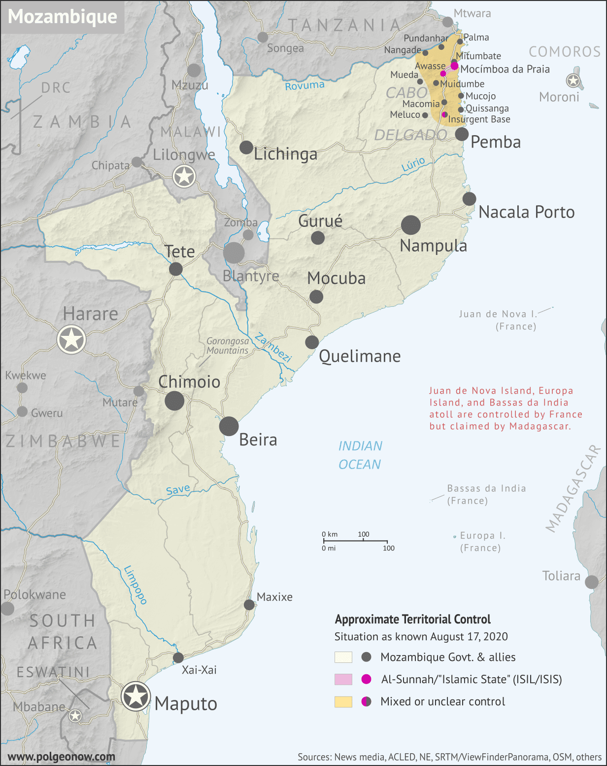
Map by Evan Centanni and Djordje Djukic. Contact us for permission to use this map. Terrain data sourced from ViewFinderPanoramas.

(Subscribers click here to view this article in the member area)

Article by Evan Centanni and Djordje Djukic

Northern Mozambique's Insurgency: What We Do and Don't Know

Mozambique: Cabo Delgado insurgency map - October 2017 to August 2020: Detailed, close-up control map showing areas occupied by so-called ISIS-linked rebels in northern Mozambique (also known as Ahlu Sunnah Wa Jama, ASWJ, or Ansar al-Sunnah), plus towns and villages raided by the insurgents over the past three years. Shows roads, rivers, and terrain, and includes key locations of the insurgency such as Mocímboa da Praia, Awasse, Macomia, the Total LNG site and natural gas fields, Miangalewa, Litingina, Ntessa, Cagembe, Marere, Makulo, and many, many more. Colorblind accessible.
Close-up version of the above map, with expanded timeline (subscriber exclusive; click for more info).
International headlines broke last week describing a takeover of a northern Mozambique "city" by what many of them called the "Islamic State" (IS; formerly ISIS/ISIL). If this came as a complete surprise to you, you're not alone - even international analysts were startled when the insurgency began in 2017, and though the insurgents have actually overrun Mocímboa da Praia more than once since then, news coverage has been pretty limited.

At PolGeoNow, researcher Djordje Djukic has been keeping an eye on this conflict for some time, and we're now pleased to present what we believe to be the world's first map series documenting territorial control in the northern Mozambique insurgency. 

Update: A much more detailed close-up version of the above map, adding insurgent raids and accompanied by an expanded timeline, is now available to our paid subscribers.

Monday, August 10, 2020

All About Kazakhstan's 2019 Capital Name Change

At PolGeoNow, our goal is to inform you whenever a country changes its name, capital, or flag. So even though we sometimes fall behind, we want to make sure you don't miss out completely on stories like this one from last year.

Map of Kazakhstan and the location of its capital city, Nur-Sultan (Nursultan), formerly Astana, as well as largest city Almaty
Contact us for permission to use this map.

Astana is Now Nur-Sultan

In March of last year, the Republic of Kazakhstan in central Asia announced that it was changing the name of its capital city. The day after President Nursultan Nazarbayev announced his resignation, the incoming interim president declared that the city, Astana, would be renamed "Nur-Sultan" in honor of the previous president.

Friday, July 31, 2020

Syria Control Map & Report: Frontlines Stable - July 2020

There are newer versions of this map available. To see them, view all Syria updates.

This is a free edition of our Syria control map series. If you want access to our full collection of Syria maps, you can sign up for our conflict map subscription service. 

Syrian Civil War map: Territorial control in Syria in late July 2020 (Free Syrian Army rebels, Kurdish YPG, Syrian Democratic Forces (SDF), Hayat Tahrir al-Sham (HTS / Al-Nusra Front), Islamic State (ISIS/ISIL), and others). Includes Turkish/TFSA control, joint SDF-Assad control, US deconfliction zone, and Turkey-Russia security corridor, plus recent locations of conflict and territorial control changes, including Suknah, Abu Kamal, Idlib, and more. Colorblind accessible.
Base map by Koen Adams of onestopmap.com, with territorial control by Evan Centanni and Djordje Djukic.
Contact us for permission to use this map.

(Subscribers click here to view this article in the member area)

Timeline by Djordje Djukic

Syrian Civil War Update: July 2020

In the four months since our previous Syria control map report, the lines of control have almost all stayed the same, with back-and-forth fighting between the sides not resulting in lasting territorial changes. The exception is in Syria's central desert, where estimates of so-called "Islamic State" (IS; formerly ISIS/ISIL) control have shrunk to include only the area surrounding the Doubayat Gas Field. Meanwhile, joint Russian-Turkish patrols have begun along the Idlib "security corridor", and Israeli airstrikes against Iranian and Hezbollah forces have become common.

Sunday, July 26, 2020

Yemen Control Map & Report: Separatists Take Socotra - July 2020 (Subscription)

SUBSCRIBERS CLICK HERE TO PROCEED TO ARTICLE AND MAP

There are newer versions of this map available. To see them, view all Yemen articles on PolGeoNow.

Timeline by Djordje Djukic. Map by Evan Centanni, Djordje Djukic, and onestopmap.com

Map of what's happening in Yemen as of July 2020, including territorial control for the unrecognized Houthi government, president-in-exile Hadi and his allies in the Saudi-led coalition, the UAE-backed southern separatist Southern Transitional Council (STC), and Al Qaeda in the Arabian Peninsula (AQAP). Includes recent locations of fighting and other events, including Socotra, Qaniya, Radman, Ja'ar, Jardan, and more.
Subscribe for full access to all conflict map reports!

In the last two months, Yemen's internationally-recognized government has lost more ground to both northern Houthi forces and southern separatists, including a separatist takeover over the entire island province of Socotra.

See all this and more on the newest update to PolGeoNow's Yemen territorial control map, which includes a timeline of changes and important events since our previous Yemen map report in May.

This map and report are premium content available to paid subscribers of the PolGeoNow Conflict Mapping Service.

Want to see before you buy? Check out our most recent FREE SAMPLE Yemen map report!

Exclusive report includes:
  • Up-to-date map of current territorial control in Yemen, color-coded for the pro-Hadi coalition, the separatist Southern Transitional Council (STC), Houthi forces, and Al Qaeda in the Arabian Peninsula (AQAP)
  • Detailed indication of town-by-town control, including provincial boundaries, all major cities, and many smaller ones
  • Markers for recent areas of fighting, including Hadibu, Qaniya, Radman, Ja'ar, Jardan, and more
  • Timeline of changes to the situation since May 20, 2020, with links to sources 

SUBSCRIBERS CLICK HERE TO PROCEED TO ARTICLE AND MAP

Not a member yet? Click here to learn more about our professional subscription service!

Can I purchase just this map?
This map and report are not available for automated purchase to non-subscribers. If you need access or republication rights for only this map report, contact service@polgeonow.com for options.

Thursday, July 16, 2020

Bulgaria and Croatia Enter Eurozone "Waiting Room" (ERM II)

This article covers the latest changes to PolGeoNow's map of which countries use the euro.

Map of the Eurozone (euro area), showing which countries use the euro as their currency. Includes members, pre-members (ERM II or ERM-2 waiting area), EU non-members using the euro, and other EU countries (color blind accessible). Updated for July 2020 with the entry of Croatia and Bulgaria into the ERM-II.
The Eurozone, European Union, and other countries using the euro.
Map by Evan Centanni, from blank map by Ssolbergj. License: CC BY-SA

Croatia and Bulgaria preparing to adopt the euro

The southeastern European countries of Bulgaria and Croatia have been approved by the European Union's central bank to take the next step towards joining the Eurozone - the organization of countries that officially use the euro as their shared currency. As new participants in the "European Exchange Rate Mechanism II" (ERM II or ERM-2), Croatia and Bulgaria are on track to adopt the euro after a 2-3 year waiting period - likely on January 1, 2024.