Friday, July 31, 2020

Syria Control Map & Report: Frontlines Stable - July 2020

There are newer versions of this map available. To see them, view all Syria updates.

This is a free edition of our Syria control map series. If you want access to our full collection of Syria maps, you can sign up for our conflict map subscription service. 

Syrian Civil War map: Territorial control in Syria in late July 2020 (Free Syrian Army rebels, Kurdish YPG, Syrian Democratic Forces (SDF), Hayat Tahrir al-Sham (HTS / Al-Nusra Front), Islamic State (ISIS/ISIL), and others). Includes Turkish/TFSA control, joint SDF-Assad control, US deconfliction zone, and Turkey-Russia security corridor, plus recent locations of conflict and territorial control changes, including Suknah, Abu Kamal, Idlib, and more. Colorblind accessible.
Base map by Koen Adams of onestopmap.com, with territorial control by Evan Centanni and Djordje Djukic.
Contact us for permission to use this map.

(Subscribers click here to view this article in the member area)

Timeline by Djordje Djukic

Syrian Civil War Update: July 2020

In the four months since our previous Syria control map report, the lines of control have almost all stayed the same, with back-and-forth fighting between the sides not resulting in lasting territorial changes. The exception is in Syria's central desert, where estimates of so-called "Islamic State" (IS; formerly ISIS/ISIL) control have shrunk to include only the area surrounding the Doubayat Gas Field. Meanwhile, joint Russian-Turkish patrols have begun along the Idlib "security corridor", and Israeli airstrikes against Iranian and Hezbollah forces have become common.

Sunday, July 26, 2020

Yemen Control Map & Report: Separatists Take Socotra - July 2020 (Subscription)

SUBSCRIBERS CLICK HERE TO PROCEED TO ARTICLE AND MAP

There are newer versions of this map available. To see them, view all Yemen articles on PolGeoNow.

Timeline by Djordje Djukic. Map by Evan Centanni, Djordje Djukic, and onestopmap.com

Map of what's happening in Yemen as of July 2020, including territorial control for the unrecognized Houthi government, president-in-exile Hadi and his allies in the Saudi-led coalition, the UAE-backed southern separatist Southern Transitional Council (STC), and Al Qaeda in the Arabian Peninsula (AQAP). Includes recent locations of fighting and other events, including Socotra, Qaniya, Radman, Ja'ar, Jardan, and more.
Subscribe for full access to all conflict map reports!

In the last two months, Yemen's internationally-recognized government has lost more ground to both northern Houthi forces and southern separatists, including a separatist takeover over the entire island province of Socotra.

See all this and more on the newest update to PolGeoNow's Yemen territorial control map, which includes a timeline of changes and important events since our previous Yemen map report in May.

This map and report are premium content available to paid subscribers of the PolGeoNow Conflict Mapping Service.

Want to see before you buy? Check out our most recent FREE SAMPLE Yemen map report!

Exclusive report includes:
  • Up-to-date map of current territorial control in Yemen, color-coded for the pro-Hadi coalition, the separatist Southern Transitional Council (STC), Houthi forces, and Al Qaeda in the Arabian Peninsula (AQAP)
  • Detailed indication of town-by-town control, including provincial boundaries, all major cities, and many smaller ones
  • Markers for recent areas of fighting, including Hadibu, Qaniya, Radman, Ja'ar, Jardan, and more
  • Timeline of changes to the situation since May 20, 2020, with links to sources 

SUBSCRIBERS CLICK HERE TO PROCEED TO ARTICLE AND MAP

Not a member yet? Click here to learn more about our professional subscription service!

Can I purchase just this map?
This map and report are not available for automated purchase to non-subscribers. If you need access or republication rights for only this map report, contact service@polgeonow.com for options.

Thursday, July 16, 2020

Bulgaria and Croatia Enter Eurozone "Waiting Room" (ERM II)

This article covers the latest changes to PolGeoNow's map of which countries use the euro.

Map of the Eurozone (euro area), showing which countries use the euro as their currency. Includes members, pre-members (ERM II or ERM-2 waiting area), EU non-members using the euro, and other EU countries (color blind accessible). Updated for July 2020 with the entry of Croatia and Bulgaria into the ERM-II.
The Eurozone, European Union, and other countries using the euro.
Map by Evan Centanni, from blank map by Ssolbergj. License: CC BY-SA

Croatia and Bulgaria preparing to adopt the euro

The southeastern European countries of Bulgaria and Croatia have been approved by the European Union's central bank to take the next step towards joining the Eurozone - the organization of countries that officially use the euro as their shared currency. As new participants in the "European Exchange Rate Mechanism II" (ERM II or ERM-2), Croatia and Bulgaria are on track to adopt the euro after a 2-3 year waiting period - likely on January 1, 2024.

Which Countries Used the Euro in 2020? (Map of the Eurozone)

There's a newer version of this map and article available. You can always find the latest version at this link: Which Countries Use the Euro Today? (Map of the Eurozone)

This is the archived 2020 version of our Eurozone map and explainer article, which itself was updated from an article originally published in June 2016, with the earliest version of the map appearing in a 2014 news post.

Map of the Eurozone (euro area), showing which countries use the euro as their currency. Includes members, pre-members (ERM II or ERM-2 waiting area), EU non-members using the euro, and other EU countries (color blind accessible). Updated for July 2020 with the entry of Croatia and Bulgaria into the ERM-II.
The Eurozone, European Union, and other countries using the euro.
Map by Evan Centanni, from blank map by Ssolbergj. License: CC BY-SA

Article by Caleb Centanni, with additional content by Evan Centanni 

What is the Eurozone?

Officially called the "euro area", the Eurozone is a nickname for the group of countries in Europe that share a single currency, called the euro. The euro currency is administered by the European Union (EU), but many countries in the EU don't use the euro, and some countries outside the EU do use it. The European Central Bank, the governing financial body of the Eurozone, is headquartered in Frankfurt, Germany. Germany, along with eleven other EU countries, became a founding member of the Eurozone in 1999.

Sunday, July 12, 2020

NAFTA Replaced With USMCA/CUSMA

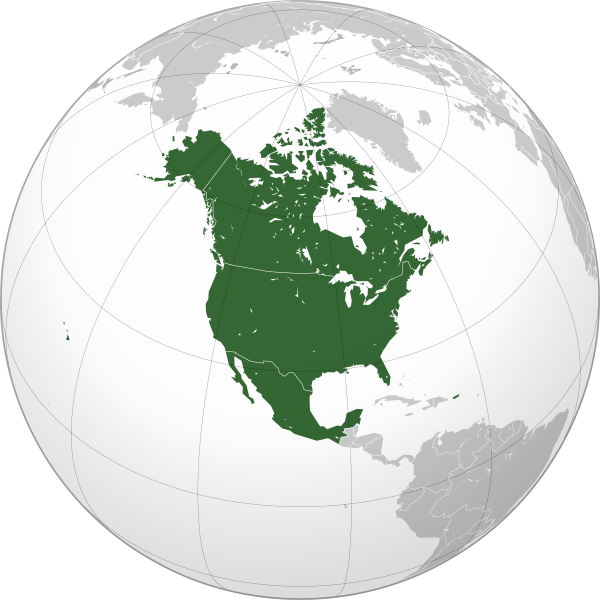
CUSMA/USMCA replaces NAFTA as the new free trade area made up of Mexico, the US, and Canada. Map by Wikimedia user Heraldry (source; CC BY-SA)

NAFTA is No More

On July 1, the North American Free Trade Agreement (NAFTA) - a much-talked-about free trade area including Mexico, the United States, and Canada - was formally retired. The arrangement, in place since 1994, has been replaced by a similar deal, technically called the "Agreement Between the United States of America, the United Mexican States, and Canada". The change was agreed upon last year, but didn't take effect until this month.

USMCA or CUSMA?

The short name of the deal depends on who you ask. In the US, it's called the United States-Mexico-Canada Agreement (USMCA), but in Canada it's the Canada-United States-Mexico Agreement (CUSMA). In French (Canada's other official language) the acronym is ACEUM - also placing "Canada" first - and in Mexico it's known by the Spanish acronym T-MEC (placing "Mexico" first).