Monday, June 22, 2020

Libyan Civil War Map & Timeline: Tables Turned in Tripoli - June 2020 (Subscription)

SUBSCRIBERS CLICK HERE TO PROCEED TO ARTICLE AND MAP

There are newer versions of this map available. To see them, view all Libya updates.

Research by Djordje Djukic. Map by onestopmap.com, Evan Centanni, and Djordje Djukic.

Subscribe for full access to all conflict map reports!

Libya: Who controls what? A concise, professional map of who controls Libya now (June 2020). Shows detailed territorial control in the Libyan Civil War as of June 21, 2020, including all major parties (Government of National Accord (GNA); Tobruk House of Representatives, General Haftar's Libyan National Army (LNA), and allies; Tuareg and Toubou (Tebu, Tubu) militias in the south; and the so-called Islamic State (ISIS/ISIL)). Includes terrain, major roads, and recent locations of interest including the Tripoli International Airport, Tarhuna, Bani Walid, Qurayyat, and more. Colorblind accessible. Over the past few weeks, the tables have turned dramatically in western Libya, with the LNA driven completely out of its footholds within the city of Tripoli, and expelled from almost the whole northwest. 

See all this and more on the latest update to PolGeoNow's concise, professional Libyan Civil War control map, which comes with a timeline of changes since our previous Libya control map report of May 29, 2020.

This map and report are premium content available to paid subscribers of the PolGeoNow Conflict Mapping Service.

Want to see before you subscribe? Check out our most recent FREE SAMPLE Libya map!

Exclusive report includes:
  • Up-to-date map of current territorial control in Libya, color-coded for the UN-backed Government of National Accord (GNA), the rival Tobruk parliament and Khalifa Haftar's Libyan National Army (LNA), the so-called "Islamic State" (ISIS/ISIL), and Toubou and Tuareg militias in the south. Colorblind accessible.
  • Detailed indication of city-by-city control, including key towns and other locations important to current events.
  • Locations of recent fighting and changes of control, including the Tripoli International Airport, Tarhuna, Bani Walid, Qurayyat, and more.
  • Detailed timeline of important events and changes to territorial control since May 29, 2020, with links to sources.

SUBSCRIBERS CLICK HERE TO PROCEED TO ARTICLE AND MAP

Not signed up yet? Click here to learn more about our professional subscription service!

Can I purchase just this map?
This map and report are not available for automated purchase to non-subscribers. If you need access or republication rights for only this map report, please contact service@polgeonow.com for options.

Saturday, June 6, 2020

The USA is Still a WHO Member

Update: On July 7, 2020, the US government under President Donald Trump officially began the one-year process of withdrawing from the WHO. However, the next US president, Joe Biden, then canceled the process on January 20, 2021, almost six months before the country would have actually left. The US never officially stopped being a member of the WHO, and is no longer planning to leave.

The World Health Organization includes almost every country in the world, coordinated by six different regional offices (public domain map; source).

Is the US leaving the WHO?

Last weekend US president Donald Trump made a statement that seemed to imply the country was withdrawing from membership in the World Health Organization (WHO).

Citing accusations that the body is overly influenced by China, the US president said "We will be today terminating our relationship with the World Health Organization".

Bu what exactly does that mean?

Friday, May 29, 2020

Libyan Civil War Map & Timeline - May 2020

There are newer versions of this map available. To see them, view all Libya updates.

This is a free edition of our Libya control map series. If you want access to our full collection of Libya maps, you can sign up for our conflict map subscription service.

Libya: Who controls what? A concise, professional map of who controls Libya now (May 2020). Shows detailed territorial control in the Libyan Civil War as of May 29, 2020, including all major parties (Government of National Accord (GNA); Tobruk House of Representatives, General Haftar's Libyan National Army (LNA), and allies; Tuareg and Toubou (Tebu, Tubu) militias in the south; and the so-called Islamic State (ISIS/ISIL)). Includes terrain, major roads, and recent locations of interest including Al-Watiyah Airbase, Tarhuna, Mizda, and more. Colorblind accessible.
Base map by Koen Adams of onestopmap.com, with territorial control by Evan Centanni and Djordje Djukic.
Contact us for permission to use this map.

(Subscribers click here to view this article in the member area)

Timeline by Djordje Djukic, with additional reporting by Evan Centanni


Mapping Control in Libya as Proxy War Escalates

Since the time of our previous Libya control map report last month, the country's UN-recognized Government of National Accord (GNA) has continued to gain ground in the west amid a major withdrawal of the rival Libyan National Army (LNA). The GNA's gains have been achieved with extensive support from Turkey, in the form of thousands of Turkish-allied Syrian rebel fighters as well as many Turkish-provided drones, in what the UN has called "the largest drone war in the world". Meanwhile, the LNA now has its own allied Syrian fighting force, brought in to support Russian private military contractors (PMCs), who are widely claimed to have the full support of Russia's government.

Thursday, May 28, 2020

Bougainville Independence Update: Is Bougainville a Country Yet?

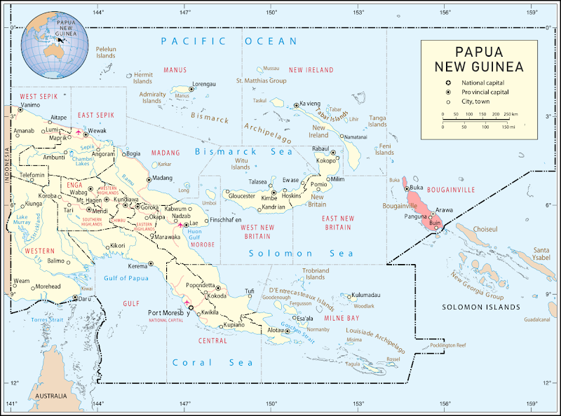
Where is Bougainville island located? Map of Bougainville's location within Papua New Guinea.
Bougainville (in red) is currently part of Papua New Guinea.
(Modified from a public-domain UN map)

Is Bougainville Independent Yet?

Late last year, the South Pacific island region of Bougainville voted overwhelmingly for independence from Papua New Guinea, in a carefully-planned and agreed-upon referendum.

So five months later, is Bougainville a country now? The short answer is no - at least not yet.

Friday, May 22, 2020

Yemen Control Map & Report: Separatist Conflict Expands - May 2020 (Subscription)

SUBSCRIBERS CLICK HERE TO PROCEED TO ARTICLE AND MAP

There are newer versions of this map available. To see them, view all Yemen articles on PolGeoNow.

Timeline by Djordje Djukic. Map by Evan Centanni, Djordje Djukic, and onestopmap.com

Map of what's happening in Yemen as of May 2020, including territorial control for the unrecognized Houthi government, president-in-exile Hadi and his allies in the Saudi-led coalition, the UAE-backed southern separatist Southern Transitional Council (STC), and Al Qaeda in the Arabian Peninsula (AQAP). Includes recent locations of fighting and other events, including Hadibu, al-Labanat, al-Khanjar, Balhaf, Jufra base, and more.
Subscribe for full access to all conflict map reports!

Since March, Houthi forces have continued advancing eastwards, while the conflict between the Hadi government and southern separatists has erupted into open warfare, expanding as far as the remote island province of Socotra.

See all this and more on the newest update to PolGeoNow's Yemen territorial control map, which includes a timeline of changes and important events since our previous Yemen map report in March.

This map and report are premium content available to paid subscribers of the PolGeoNow Conflict Mapping Service.

Want to see before you buy? Check out our most recent FREE SAMPLE Yemen map report!

Exclusive report includes:
  • Up-to-date map of current territorial control in Yemen, color-coded for the pro-Hadi coalition, the separatist Southern Transitional Council (STC), Houthi forces, and Al Qaeda in the Arabian Peninsula (AQAP)
  • Detailed indication of town-by-town control, including provincial boundaries, all major cities, and many smaller ones
  • Markers for recent areas of fighting, including Hadibu, al-Labanat, al-Khanjar, Balhaf, Jufra base, and more
  • Timeline of changes to the situation since March 29, 2020, with links to sources 

SUBSCRIBERS CLICK HERE TO PROCEED TO ARTICLE AND MAP

Not a member yet? Click here to learn more about our professional subscription service!

Can I purchase just this map?
This map and report are not available for automated purchase to non-subscribers. If you need access or republication rights for only this map report, contact service@polgeonow.com for options.