Sunday, March 22, 2020

Syrian Civil War Map & Timeline: New Ceasefire Lines in Northwest - March 2020 (Subscription)

SUBSCRIBERS CLICK HERE TO PROCEED TO ARTICLE AND MAP

There are newer versions of this map available. To see them, view all Syria updates.

Research by Djordje Djukic. Map by onestopmap.com, Evan Centanni, and Djordje Djukic

Subscribe for full access to all conflict map reports!

Map of Syrian Civil War (Syria control map): Territorial control in Syria in March 2020 (Free Syrian Army rebels, Kurdish YPG, Syrian Democratic Forces (SDF), Hayat Tahrir al-Sham (HTS / Al-Nusra Front), Islamic State (ISIS/ISIL), and others). Includes Turkish/TFSA control, joint SDF-Assad control, US deconfliction zone, and Turkey-Russia security corridor, plus recent locations of conflict and territorial control changes, including Kafr Nabl, Nayrab, Anadan, Al Sanamayn, and more. Colorblind accessible. Since last month, Syria's Assad government has gained more ground against the rebels and come into direct conflict with the Turkish military. Now, a deal between Russia and Turkey has brought a new ceasefire to the area.

See all this and more on the latest update to PolGeoNow's concise, professional Syrian Civil War control map, which includes a timeline of changes since our previous Syria map report in February, with sources cited.

This map and report are premium content, available to paid subscribers of the PolGeoNow Conflict Mapping Service.

Want to see before you subscribe? Check out our most recent FREE SAMPLE Syria map!

Exclusive map report includes:
  • Up-to-date illustration of current territorial control in Syria, color-coded for the Assad government, rebel groups, "Islamic State" (ISIS/ISIL) fighters, and the Kurdish-led Syrian Democratic Forces (SDF). Colorblind accessible.
  • Special symbols for joint Turkish/rebel control and joint SDF/government control in the border region
  • Extent of "security corridor" sponsored by Turkey and Russia in the rebel-held northwest
  • Outline showing approximate location of the one publicly-known US "deconfliction zone"
  • Special symbols indicating towns dominated by rebels of the former Al Qaeda Nusra Front (now Hayat Tahrir al-Sham or HTS) and by the Kurdish YPG militia (part of the SDF anti-IS coalition)
  • Detailed indication of city-by-city control, including key towns and other locations important to current events
  • Locations of recent control changes and other important events, including Kafr Nabl, Nayrab, Anadan, Al Sanamayn, and more
  • Detailed timeline of important events and changes to territorial control since February 14, 2020, compiled by our Syria-Iraq expert, with links to sources.

SUBSCRIBERS CLICK HERE TO PROCEED TO ARTICLE AND MAP

Not signed up yet? Click here to learn more about our professional subscription service!

Can I purchase just this map?
This map and report are not available for automated purchase to non-subscribers. If you need access or republication rights for only this map report, contact service@polgeonow.com for options.

Monday, February 17, 2020

Yemen Control Map & Report - February 2020 (Subscription)

SUBSCRIBERS CLICK HERE TO PROCEED TO ARTICLE AND MAP

There are newer versions of this map available. To see them, view all Yemen articles on PolGeoNow.

Timeline by Djordje Djukic. Map by Evan Centanni, Djordje Djukic, and onestopmap.com

Map of what is happening in Yemen as of February 2020, including territorial control for the unrecognized Houthi government, president-in-exile Hadi and his allies in the Saudi-led coalition, the UAE-backed southern separatist Southern Transitional Council (STC), and Al Qaeda in the Arabian Peninsula (AQAP). Includes recent locations of fighting and other events, such as Nihm, Majzar, Yakla, and more.
Subscribe for full access to all conflict map reports!

Over the past two months, the Houthi government has gained some ground in central Yemen against the internationally-backed government of President Hadi, and separatists still hold key towns in the south despite shrinking estimates of their total control.

See all this and more on the newest update to PolGeoNow's Yemen territorial control map, which includes a timeline of changes and important events since our previous Yemen map report in December.

This map and report are premium content available to paid subscribers of the PolGeoNow Conflict Mapping Service.

Want to see before you buy? Check out our most recent FREE SAMPLE Yemen map report!

Exclusive report includes:
  • Up-to-date map of current territorial control in Yemen, color-coded for the pro-Hadi coalition, the separatist Southern Transitional Council (STC), Houthi forces, and Al Qaeda in the Arabian Peninsula (AQAP).
  • Detailed indication of town-by-town control, including provincial boundaries, all major cities, and many smaller ones
  • Markers for recent areas of fighting, including Nihm, Majzar, Yakla, and more
  • Timeline of changes to the situation since December 15, 2019, with links to sources 

SUBSCRIBERS CLICK HERE TO PROCEED TO ARTICLE AND MAP

Not a member yet? Click here to learn more about our professional subscription service!

Can I purchase just this map?
This map and report are not available for automated purchase to non-subscribers. If you need access or republication rights for only this map report, contact service@polgeonow.com for options.

Friday, February 14, 2020

Syrian Civil War Map & Timeline: Assad Retakes Key Highway - February 2020 (Subscription)

SUBSCRIBERS CLICK HERE TO PROCEED TO ARTICLE AND MAP

There are newer versions of this map available. To see them, view all Syria updates.

Research by Djordje Djukic. Map by onestopmap.com, Evan Centanni, and Djordje Djukic

Subscribe for full access to all conflict map reports!

Map of Syrian Civil War (Syria control map): Territorial control in Syria in February 2020 (Free Syrian Army rebels, Kurdish YPG, Syrian Democratic Forces (SDF), Hayat Tahrir al-Sham (HTS / Al-Nusra Front), Islamic State (ISIS/ISIL), and others). Includes Turkish/TFSA control, joint SDF-Assad control, US deconfliction zone, and Turkey-Russia demilitarized buffer zone, plus recent locations of conflict and territorial control changes, including Marat al-Numan, Saraqeb, Regiment 46, Al-Eiss, and more. Colorblind accessible. Over the past month, forces loyal to Syria's Assad government have many major gains in the northwest, capturing two rebel strongholds and reestablishing control along the entire Damascus-Aleppo highway for the first time in eight years.

 See all this and more on the latest update to PolGeoNow's concise, professional Syrian Civil War control map, which includes a timeline of changes since our previous Syria map report in January, with sources cited.

This map and report are premium content, available to paid subscribers of the PolGeoNow Conflict Mapping Service.

Want to see before you subscribe? Check out our most recent FREE SAMPLE Syria map!

Exclusive map report includes:
  • Up-to-date illustration of current territorial control in Syria, color-coded for the Assad government, rebel groups, "Islamic State" (ISIS/ISIL) fighters, and the Kurdish-led Syrian Democratic Forces (SDF). Colorblind accessible.
  • Special symbols for joint Turkish/rebel control and joint SDF/government control in the border region
  • Extent of "buffer zone" sponsored by Turkey and Russia in the rebel-held northwest
  • Outline showing approximate location of the one publicly-known US "deconfliction zone"
  • Special symbols indicating towns dominated by rebels of the former Al Qaeda Nusra Front (now Hayat Tahrir al-Sham or HTS) and by the Kurdish YPG militia (part of the SDF anti-IS coalition)
  • Detailed indication of city-by-city control, including key towns and other locations important to current events
  • Locations of recent control changes and other important events, including Marat al-Numan, Saraqeb, the Regiment 46 base, Al-Eiss, and more
  • Detailed timeline of important events and changes to territorial control since January 20, 2020, compiled by our Syria-Iraq expert, with links to sources.

SUBSCRIBERS CLICK HERE TO PROCEED TO ARTICLE AND MAP

Not signed up yet? Click here to learn more about our professional subscription service!

Can I purchase just this map?
This map and report are not available for automated purchase to non-subscribers. If you need access or republication rights for only this map report, contact service@polgeonow.com for options.
Saturday, February 8, 2020

Brexit: UK Leaves European Union (Plus: What Actually Changed?)

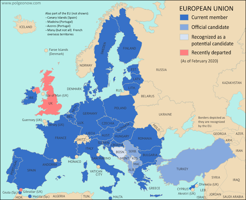
Map of the European Union, including all member countries, official candidate countries, and potential candidate countries, as of February 2020, updated for Brexit - the departure of the UK and Gibraltar (colorblind accessible). Also file under: Map of European Union Member Countries.

Map by Evan Centanni, from blank map by Ssolbergj. License: CC BY-SA

Britain Finally Exits EU

Last week, the United Kingdom of Great Britain and Northern Ireland - "UK" or "Britain" for short - became the first country ever to formally leave the European Union (EU).

This marks the turning point, but not the end, of the years-long saga nicknamed "Brexit" (short for "British exit"), which started with a 2016 referendum.

The long-delayed official exit finally arrived in the first second of February 1, 2020 at the EU headquarters in Belgium. Because of a time zone difference, this was 11:00 pm of January 31 in the UK. But because of a negotiated "transition period", most practical changes won't go into effect until at least the end of this year (read on for more about that).

The British territory of Gibraltar, located along the southern coast of Spain, was also pulled out of the EU alongside the UK.

How it Happened: A Concise Timeline of Brexit

Map of the European Union, including all member countries, official candidate countries, and potential candidate countries, as of February 2020, updated for Brexit - the departure of the UK and Gibraltar (colorblind accessible). Also file under: Map of European Union Member Countries.

Map by Evan Centanni, from blank map by Ssolbergj. License: CC BY-SA

UK Leaves EU: What Were They Doing All That Time?

Last week, the UK actually left the European Union, in a long-anticipated move called for by a referendum vote in 2016. This British exit, or "Brexit" was never meant to happen in less than two years - by how did it stretch out to almost four?

We've put together a clear and concise timeline summarizing the process, without any of the confusing technical lingo or agonizing political details. Enjoy!