Saturday, January 11, 2020

How Many Countries Are There in the World in 2020?

There are newer editions of this article available. To find the most recent, view all "How Many Countries in the World" updates!

This article, originally from 2011, has been revised and updated to January 2020. You can view some older versions of the article in our archives.

How many countries: map of the world
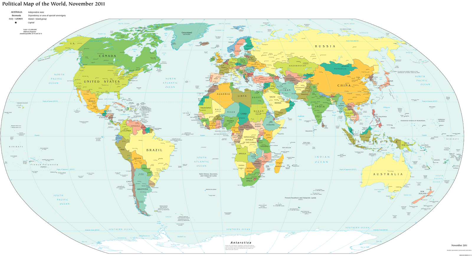
A world political map published by the US government.
One of the most basic questions for map-lovers is, "How many countries are there in the world?" But anyone who just gives you a number isn't telling the whole truth. It actually depends a lot on how you define a "country".

Here are six of the most common answers, each correct in its own way:

Iraq Control Map & Timeline - January 2020

There are newer versions of this map available. To see them, view all Iraq updates.

Iraq Control Map 2020, updated to January 10. Shows areas of Iraq under ISIS control (Islamic State/ISIL/Daesh), and under the control of the Baghdad government, the Kurdistan Peshmerga, and the Yezidi Sinjar Alliance (YBS and YJE). Colorblind accessible.
Basemap by Koen Adams of onestopmap.com, with territorial control by Evan Centanni and Djordje Djukic.
Contact us for permission to use this map.
(Subscribers click here to view this article in the member area)

Timeline by Djordje Djukic, with additional reporting by Evan Centanni

Iraq Map: Who Controls What in 2020

In the nearly two years since our previous Iraq control map update, there have been few major changes to the situation on the ground. But the so-called "Islamic State" (IS; formerly ISIS/ISIL) isn't gone, and recent reports say the group has begun regaining power in the country's north. Tensions have also escalated recently between the US and Iran - both countries are heavily involved in Iraq, and have long competed for influence there. Meanwhile, the self-governed Kurdistan region remains in control of the far north, despite having lost some its claimed territory to the Iraqi central government in the aftermath of its controversial 2017 independence vote.

Tuesday, December 31, 2019

Somalia Control Map & Timeline - December 2019 (Subscription)

SUBSCRIBERS CLICK HERE TO PROCEED TO ARTICLE AND MAP

There are newer versions of this map available. To see them, view all Somalia articles on PolGeoNow.

Map by onestopmap.com, Evan Centanni, and Djordje Djukic

Subscribe for full access to all conflict map reports!

Who controls Somalia? Map (end of 2019). With states, regions, and territorial control. Best Somalia control map online, thoroughly researched, detailed but concise. Shows territorial control by Federal Government of Somalia (FGS), Al Shabaab, so-called Islamic State (ISIS/ISIL), separatist Somaliland, and autonomous states Puntland and Galmudug, plus boundaries of federal states Jubaland, South West, and Hirshabelle. Updated to December 31, 2019. Colorblind accessible.
Since August, pro-federal forces have chipped away a bit at Al Shabaab's still-significant territory in Somalia, while disputes have raged between the federal government and the state administrations of Jubaland and Galmudug. Meanwhile, Al Shabaab claims to have captured a town in northern Somaliland.

See all this and more on the latest update to PolGeoNow's concise, professional Somalia control map, which includes a timeline of changes since our previous Somalia map report of August 2019, with sources cited.

This map and report are premium content, available to paid subscribers of the PolGeoNow Conflict Mapping Service.

Want to see before you subscribe? Check out our most recent FREE SAMPLE Somalia map!

Exclusive map report includes:
  • Up-to-date illustration of current territorial control in Somalia, color-coded for the federal government coalition (including AMISOM peacekeepers), autonomous unionist forces, separatist Somaliland, Al Qaeda affiliate Al Shabaab, and fighters aligned to the so-called "Islamic State" (ISIS/ISIL). Areas of lawlessness or unclear control indicated separately. Colorblind accessible.
  • Boundaries and labels for Somalia's official regions and states, including the autonomous administrations of Somaliland, Puntland, and Galmudug as well as the federally-supported Jubaland, South West, and Hirshabelle states.
  • Detailed indication of city-by-city control, including many relevant smaller towns and villages.
  • Locations of recent fighting and other important events, including Bal'ad, Qayib, Amara, Ga'an Marodi, and more.
  • Detailed timeline of territorial control changes and key political developments since August 13, 2019, with sources cited. 
  • Brief summary of the conflict situation and changes to the map over the past four and a half months.

SUBSCRIBERS CLICK HERE TO PROCEED TO ARTICLE AND MAP

Not signed up yet? Click here to learn more about our professional subscription service!

Saturday, December 28, 2019

Libyan Civil War Map & Timeline - December 2019 (Subscription)

SUBSCRIBERS CLICK HERE TO PROCEED TO ARTICLE AND MAP

There are newer versions of this map available. To see them, view all Libya updates.

Research by Djordje Djukic. Map by onestopmap.com, Evan Centanni, and Djordje Djukic.

Subscribe for full access to all conflict map reports!

Libya: Who controls what? A concise, professional map of who controls Libya now (December 2019). Shows detailed territorial control in the Libyan Civil War as of September 27, 2019, including all major parties (Government of National Accord (GNA); Tobruk House of Representatives, General Haftar's Libyan National Army (LNA), and allies; Tuareg and Toubou (Tebu, Tubu) militias in the south; the so-called Islamic State (ISIS/ISIL); and other groups such as the National Salvation Government (NSG)). Includes terrain, major roads, and recent locations of interest including Yarmouk Camp, Tripoli International Airport, El Feel Oilfield, Tummo border crossing, and more. Colorblind accessible. Since November, forces loyal to Libya's eastern-based government have moved closer to Tripoli's center, where they hope to unseat the country's rival western-based government, even as Turkey prepares a military intervention to defend the government in Tripoli.

See all this and more on the latest update to PolGeoNow's concise, professional Libyan Civil War control map, which comes with a timeline of changes since our previous Libya control map report of November 19, 2019.

This map and report are premium content available to paid subscribers of the PolGeoNow Conflict Mapping Service.

Want to see before you subscribe? Check out our most recent FREE SAMPLE Libya map!

Exclusive report includes:
  • Up-to-date map of current territorial control in Libya, color-coded for the UN-backed Government of National Accord (GNA), the rival Tobruk parliament and Khalifa Haftar's Libyan National Army (LNA), the so-called "Islamic State" (ISIS/ISIL), and Toubou and Tuareg militias in the south. Colorblind accessible.
  • Detailed indication of city-by-city control, including key towns and other locations important to current events.
  • Locations of recent fighting and changes of control, including Yarmouk Camp, Tripoli International Airport, El Feel Oilfield, Tummo border crossing, and more.
  • Detailed timeline of important events and changes to territorial control since November 19, 2019, with links to sources.

SUBSCRIBERS CLICK HERE TO PROCEED TO ARTICLE AND MAP

Not signed up yet? Click here to learn more about our professional subscription service!

Can I purchase just this map?
This map and report are not available for automated purchase to non-subscribers. If you need access or republication rights for only this map report, please contact service@polgeonow.com for options.

Monday, December 16, 2019

Yemen Control Map & Report - December 2019 (Subscription)

SUBSCRIBERS CLICK HERE TO PROCEED TO ARTICLE AND MAP

There are newer versions of this map available. To see them, view all Yemen articles on PolGeoNow.

Timeline by Djordje Djukic. Map by Evan Centanni, Djordje Djukic, and onestopmap.com

Map of what is happening in Yemen as of December 15, 2019, including territorial control for the unrecognized Houthi government, president-in-exile Hadi and his allies in the Saudi-led coalition, the UAE-backed southern separatist Southern Transitional Council (STC), and Al Qaeda in the Arabian Peninsula (AQAP). Includes recent locations of fighting and other events, including Ahwar, Baqim, Malahith, and more.
Subscribe for full access to all conflict map reports!

Over the past two months, separatists seeking an independent South Yemen have held onto control of port city Aden and other towns, despite attempts at reconciliation with the Saudi-backed government of President Hadi. Meanwhile, the rival Houthi government still controls much of the country.

See all this and more on the newest update to PolGeoNow's Yemen territorial control map, which includes a timeline of changes and important events since our previous Yemen map report in October.

This map and report are premium content available to paid subscribers of the PolGeoNow Conflict Mapping Service.

Want to see before you buy? Check out our most recent FREE SAMPLE Yemen map report!

Exclusive report includes:
  • Up-to-date map of current territorial control in Yemen, color-coded for the pro-Hadi coalition, the separatist Southern Transitional Council (STC), Houthi forces, and Al Qaeda in the Arabian Peninsula (AQAP).
  • Detailed indication of town-by-town control, including provincial boundaries, all major cities, and many smaller ones
  • Markers for recent areas of fighting, including Ahwar, Baqim, Malahith, and more
  • Timeline of changes to the situation since October 12, 2019, with links to sources 

SUBSCRIBERS CLICK HERE TO PROCEED TO ARTICLE AND MAP

Not a member yet? Click here to learn more about our professional subscription service!

Can I purchase just this map?
This map and report are not available for automated purchase to non-subscribers. If you need access or republication rights for only this map report, contact service@polgeonow.com for options.