Monday, November 18, 2019

Bougainville Voting on Independence from Papua New Guinea

Update: The results are in! Read our Bougainville referendum update to find out what happened!

Bougainville island and its surroundings could become the world's next independent country (public domain UN map).
This week, voting will begin in a referendum that could lead to the creation of the world's first widely-accepted new country in almost a decade. Bougainville, a group of islands in the South Pacific, will be voting on independence from Papua New Guinea.

Where did this come from? Is the referendum expected to pass? Will Bougainville really become independent? Read on for all the answers!

Tuesday, November 5, 2019

Fact Check: Is the AfCFTA the World's Second Biggest Free Trade Area?

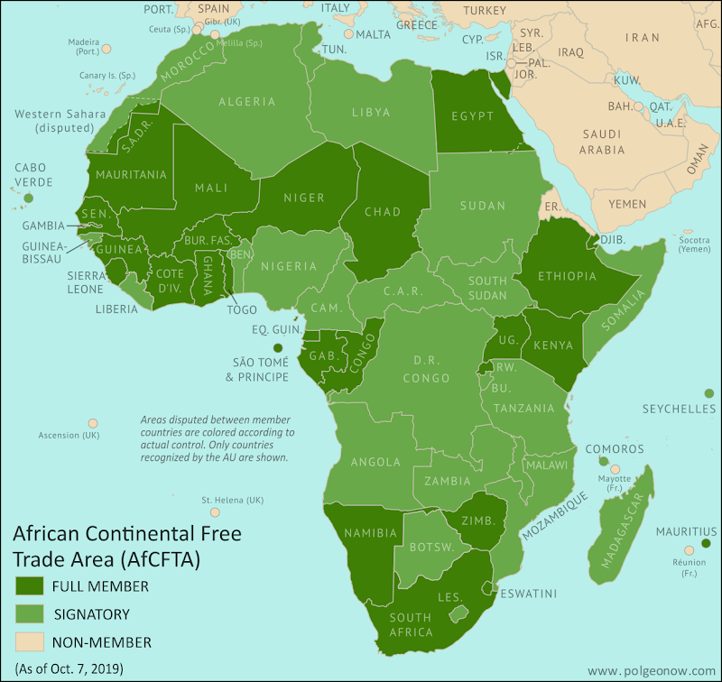
African Continental Free Trade Area countries: Map of AfCFTA members and signatories as of October 2019. Who has signed the AfCFTA, who has ratified the AfCFTA, and who has not signed. Updated for 28th ratification by Mauritius. Colorblind accessible.
The AfCFTA is planned to cover almost all of Africa, but doesn't yet.
The recently-created African Continental Free Trade Area (AfCFTA) now has 28 full member countries, with 26 more signed on to the project as future members.

That's a lot of members for a free trade area, and everyone seems to be calling it the "world's biggest free trade area since the WTO". But is that label really accurate?

(If you don't want to read the whole article, scroll down to the conclusion for a short summary.)

Sunday, October 27, 2019

Syrian Civil War Map & Timeline: Turkey Enters Northeast - October 2019 (Subscription)

SUBSCRIBERS CLICK HERE TO PROCEED TO ARTICLE AND MAP

There are newer versions of this map available. To see them, view all Syria updates.

Research by Djordje Djukic. Map by onestopmap.com, Evan Centanni, and Djordje Djukic

Subscribe for full access to all conflict map reports!

Map of Syrian Civil War (Syria control map): Territorial control in Syria in October 2019 (Free Syrian Army rebels, Kurdish YPG, Syrian Democratic Forces (SDF), Hayat Tahrir al-Sham (HTS / Al-Nusra Front), Islamic State (ISIS/ISIL), and others). Includes Turkish control, joint SDF-Assad control, US deconfliction zone, and Turkey-Russia demilitarized buffer zone, plus recent locations of conflict and territorial control changes, including Ras al-Ayn, Tel Abyad, Ayn Issa, and more. Colorblind accessible. Amid a US withdrawal, Turkey and its rebel allies have begun their long-threatened intervention against Kurdish-led fighters in northeastern Syria, who now have struck a deal with the Assad government to share their territory and jointly fight back against Turkey.

See all this and more on the latest update to PolGeoNow's concise, professional Syrian Civil War control map, which includes a timeline of changes since our previous Syria map report in September, with sources cited.

This map and report are premium content, available to paid subscribers of the PolGeoNow Conflict Mapping Service.

Want to see before you subscribe? Check out our most recent FREE SAMPLE Syria map!

Exclusive map report includes:
  • NEW: Special symbols for joint Turkish/rebel control and joint SDF/government control, so you can track Turkey's intervention in the border region
  • EXTRA: Label for Barisha village, where IS leader Abu Bakr al-Baghdadi died in a US raid this weekend
  • Up-to-date illustration of current territorial control in Syria, color-coded for the Assad government, rebel groups, "Islamic State" (ISIS/ISIL) fighters, and the Kurdish-led Syrian Democratic Forces (SDF). Colorblind accessible.
  • Extent of "buffer zone" sponsored by Turkey and Russia in the rebel-held northwest
  • Outline showing approximate location of the one publicly-known US "deconfliction zone"
  • Special symbols indicating towns dominated by rebels of the former Al Qaeda Nusra Front (now Hayat Tahrir al-Sham or HTS) and by the Kurdish YPG militia (part of the SDF anti-IS coalition).
  • Detailed indication of city-by-city control, including key towns and other locations important to current events.
  • Locations of recent control changes and other important events, including Ras al-Ayn, Tel Abyad, Ayn Issa, and more.
  • Detailed timeline of important events and changes to territorial control since September 10, 2019, compiled by our Syria-Iraq expert, with links to sources. 

SUBSCRIBERS CLICK HERE TO PROCEED TO ARTICLE AND MAP

Not signed up yet? Click here to learn more about our professional subscription service!

Can I purchase just this map?
This map and report are not available for automated purchase to non-subscribers. If you need access or republication rights for only this map report, contact service@polgeonow.com for options.

Monday, October 21, 2019

Mauritius Becomes Full Member of AfCFTA (Map)

Update: As far as can be determined, this map is still accurate as of August 2020, with no news on any deposits of ratification instruments since Mauritius. Angola, Cameroon, and Morocco are all reported to have ratified the AfCFTA treaty, but apparently haven't yet completed their membership by registering with African Union headquarters (the AU's official "status list" for the treaty hasn't been updated since October 2019, and recent reports still put the number of deposits at 28). 

In related news, the next stage of the trade area's implementation has been delayed to January 2021, but the organization's headquarters were inaugurated on August 17, 2020 in Accra, Ghana.

African Continental Free Trade Area countries: Map of AfCFTA members and signatories as of October 2019. Who has signed the AfCFTA, who has ratified the AfCFTA, and who has not signed. Updated for 28th ratification by Mauritius. Colorblind accessible.
Map by Evan Centanni, from blank map by Eric Gaba. License: CC BY-SA

Mauritius Ratifies AfCFTA Treaty

Two months ago, we reported on this year's creation of the African Continental Free Trade Area (AfCFTA), an African Union (AU) project to increase trade within Africa. Almost all of Africa's countries have signed on to the AfCFTA, but they only become full members once they've ratified its founding treaty (adopted it into their national laws) and formally registered their ratification with the AU.

Saturday, October 12, 2019

Yemen Control Map & Report - October 2019

There are newer versions of this map available. To see them, view all Yemen articles on PolGeoNow.

Map of what is happening in Yemen as of October 12, 2019, including territorial control for the unrecognized Houthi government, president-in-exile Hadi and his allies in the Saudi-led coalition, the UAE-backed southern separatist Southern Transitional Council (STC), and Al Qaeda in the Arabian Peninsula (AQAP). Includes recent locations of fighting and other events, including Ataq, Mahfad, Al Wadhea, Ketaf, and more.
Map by Evan Centanni and Djordje Djukic, from base map by Koen Adams of onestopmap.com.
Contact us for permission to use this map.
(Subscribers click here to view this article in the member area)

Timeline by Djordje Djukic

Yemen More Divided Than Ever

In the month and a half since our previous Yemen control map report, the separatists of the Southern Transitional Council (STC) have held onto control over much of the country's south, pushing the internationally-recognized Hadi government to abandon Aden and set up a new "interim capital" in the eastern town of Ataq. Meanwhile, fighting between Hadi-loyal forces and the north's rival Houthi government has continued, with both sides capturing territory from each other near the Saudi border.