 |
| Click to enlarge. By Evan Centanni, modified from public domain blank world map. Contact us for permission to use this map. |
Updates on the world's countries and borders
Sunday, December 30, 2018
Map: Which Countries Recognized Abkhazia and South Ossetia in 2018?
This is our new, completely redesigned map of which countries consider disputed South Ossetia and Abkhazia to be independent from Georgia. From now on, PolGeoNow will report on any changes to Abkhazian or South Ossetian recognition with updates to this map.
Friday, December 28, 2018
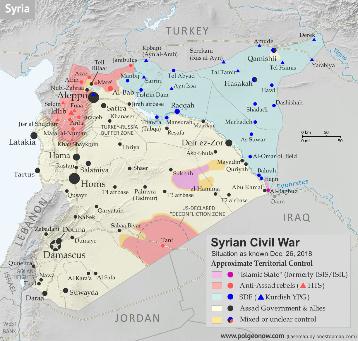
Syrian Civil War Map & Timeline: IS Loses Western Enclave - December 2018
There are newer versions of this map available. To see them, view all Syria updates.
(Subscribers click here to view this article on the member site)
Timeline by Djordje Djukic
 |
Base map by Koen Adams of onestopmap.com, with territorial control by Evan Centanni and Djordje Djukic.
Contact us for permission to use this map. |
Timeline by Djordje Djukic
Syria: Where Things Stand Now
In the month and a half since our previous Syria control map report, the main territorial changes have been losses by the so-called "Islamic State" (IS; formerly ISIS/ISIL). The Assad government has eliminated the last pocket of IS control in western Syria, in the south's Al Safa area, and the Kurdish-led Syrian Democratic Forces (SDF) have recaptured the town of Hajin in the east, while also driving IS once again off of the Syria-Iraq border.Saturday, December 8, 2018
Yemen Control Map & Report: Battle of Hodeida Begins - December 2018 (Subscription)
SUBSCRIBERS CLICK HERE TO PROCEED TO ARTICLE AND MAP
There are newer versions of this map available. To see them, view all Yemen articles on PolGeoNow.

Timeline by Djordje Djukic. Map by Evan Centanni, Djordje Djukic, and onestopmap.com
After the pro-Hadi coalition's months of stop-and-go movement towards the Houthi-held port city of Hodeida, the battle has finally moved into the city itself. Meanwhile, fighting has also continued along the Saudi border.
See all this and more on the newest update to PolGeoNow's Yemen territorial control map, which includes a timeline of changes and important events since our previous Yemen map report in September.
This map and report are premium content available to paid subscribers of the PolGeoNow Conflict Mapping Service.
Want to see before you buy? Check out our most recent FREE SAMPLE Yemen map report!
Exclusive report includes:
SUBSCRIBERS CLICK HERE TO PROCEED TO ARTICLE AND MAP
Not a member yet? Click here to learn more about our professional subscription service!
Can I purchase just this map?
This map and report are not available for automated purchase to non-subscribers. If you need access or republication rights for only this map report, contact service@polgeonow.com for options.
There are newer versions of this map available. To see them, view all Yemen articles on PolGeoNow.
After the pro-Hadi coalition's months of stop-and-go movement towards the Houthi-held port city of Hodeida, the battle has finally moved into the city itself. Meanwhile, fighting has also continued along the Saudi border.
See all this and more on the newest update to PolGeoNow's Yemen territorial control map, which includes a timeline of changes and important events since our previous Yemen map report in September.
This map and report are premium content available to paid subscribers of the PolGeoNow Conflict Mapping Service.
Want to see before you buy? Check out our most recent FREE SAMPLE Yemen map report!
Exclusive report includes:
- Up-to-date map of current territorial control in Yemen, color-coded for the pro-Hadi coalition, Houthi forces, Al Qaeda in the Arabian Peninsula (AQAP), and the so-called "Islamic State" (ISIS/ISIL)
- Detailed indication of town-by-town control, including provincial boundaries, all major cities, and many smaller ones
- Markers for recent areas of fighting, including Hodeida, Malahith, Baqim, and more
- Timeline of changes to the situation since September 12, 2018, with links to sources
SUBSCRIBERS CLICK HERE TO PROCEED TO ARTICLE AND MAP
Not a member yet? Click here to learn more about our professional subscription service!
Can I purchase just this map?
This map and report are not available for automated purchase to non-subscribers. If you need access or republication rights for only this map report, contact service@polgeonow.com for options.
Thursday, November 29, 2018
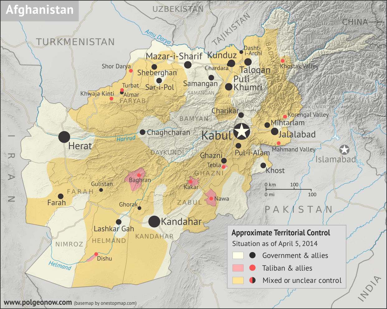
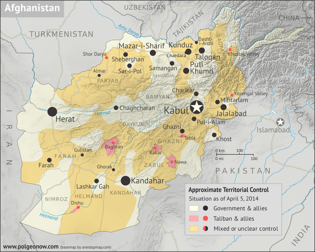
Afghanistan: Map of Taliban Control in April 2014
There are newer versions of this map available. To see them, view all Afghanistan updates.
Welcome to PolGeoNow's brand new series of Afghanistan control maps! In the coming months, we'll publish more maps spanning the gap between 2014 and 2018, leading into routine updates of the current situation. To secure your access to all future installments, sign up now for our professional conflict map subscription service!
(Subscribers click here to view this article on the member site)
Article by Evan Centanni
Welcome to PolGeoNow's brand new series of Afghanistan control maps! In the coming months, we'll publish more maps spanning the gap between 2014 and 2018, leading into routine updates of the current situation. To secure your access to all future installments, sign up now for our professional conflict map subscription service!
 |
Basemap by Koen Adams of onestopmap.com, with territorial control by Evan Centanni.
This map has been slightly revised. You can see the original here. Contact us for permission to use this map. |
Article by Evan Centanni
Afghanistan: Who Controlled What in 2014?
The date is April 5, 2014. It's been more than 12 years since a US-led invasion helped overthrow the Taliban's Islamic Emirate of Afghanistan, a religious hardline government that ruled most of the mountainous country from 1996 to 2001. Its successor, the NATO-backed Islamic Republic of Afghanistan, is voting today on a replacement for President Hamid Karzai, who has led the country ever since the Taliban government's fall in 2001.Thursday, November 15, 2018
Somalia Control Map & Timeline - November 2018 (Subscription)
SUBSCRIBERS CLICK HERE TO PROCEED TO ARTICLE AND MAP
There are newer versions of this map available. To see them, view all Somalia articles on PolGeoNow.
Map by onestopmap.com, Evan Centanni, and Djordje Djukic

Since our last update in June, Somalia's civil war has continued at its usual pace, with both Al Qaeda affiliate Al Shabaab and the Mogadishu-based government coalition capturing towns from each other. Meanwhile, the armies of Somaliland and Puntland in the north are still facing off over their disputed border.
See all this and more on the latest update to PolGeoNow's concise, professional Somalia control map, which includes a timeline of changes since our previous Somalia map report of June 2018, with sources cited.
This map and report are premium content, available to paid subscribers of the PolGeoNow Conflict Mapping Service.
Want to see before you subscribe? Check out our most recent FREE SAMPLE Somalia map!
Exclusive map report includes:
SUBSCRIBERS CLICK HERE TO PROCEED TO ARTICLE AND MAP
Not signed up yet? Click here to learn more about our professional subscription service!
There are newer versions of this map available. To see them, view all Somalia articles on PolGeoNow.
Map by onestopmap.com, Evan Centanni, and Djordje Djukic
Since our last update in June, Somalia's civil war has continued at its usual pace, with both Al Qaeda affiliate Al Shabaab and the Mogadishu-based government coalition capturing towns from each other. Meanwhile, the armies of Somaliland and Puntland in the north are still facing off over their disputed border.
See all this and more on the latest update to PolGeoNow's concise, professional Somalia control map, which includes a timeline of changes since our previous Somalia map report of June 2018, with sources cited.
This map and report are premium content, available to paid subscribers of the PolGeoNow Conflict Mapping Service.
Want to see before you subscribe? Check out our most recent FREE SAMPLE Somalia map!
Exclusive map report includes:
- Up-to-date illustration of current territorial control in Somalia, color-coded for the federal government coalition (including AMISOM peacekeepers), autonomous unionist forces, separatist Somaliland, Al Qaeda affiliate Al Shabaab, and fighters aligned to the so-called "Islamic State" (ISIS/ISIL). Areas of lawlessness or unclear control indicated separately. Colorblind accessible.
- Boundaries and labels for Somalia's official regions, plus control lines for the autonomous administrations of Somaliland, Puntland, Galmudug, and Khatumo.
- Detailed indication of city-by-city control, including many relevant smaller towns and villages.
- Locations of recent fighting and other important events, including Tukaraq, Bar Sanguni, Basra, and more.
- Detailed timeline of territorial control changes and key political developments since June 2, 2018, with sources indicated.
- Brief summary of the conflict situation, as well as major changes to the alignment of autonomous administrations, over the past five and a half months.
SUBSCRIBERS CLICK HERE TO PROCEED TO ARTICLE AND MAP
Not signed up yet? Click here to learn more about our professional subscription service!
Subscribe to:
Posts (Atom)