Monday, July 16, 2018

All About Swaziland's Name Change (With Maps)

Topographic map of Eswatini (Swaziland), showing terrain, rivers, bordering countries, and capital cities.
Eswatini, formerly known as Swaziland. Based on this map by Htonl and NordNordWest.

Swaziland's New Name

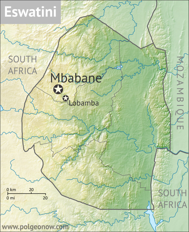
If you follow PolGeoNow on Twitter, you already know that the small, southern African country of Swaziland was renamed "Eswatini" this April. The full English name of the country, previously "Kingdom of Swaziland", has also been changed to "Kingdom of Eswatini".

The rename was first announced by the country's king on April 19 - his 50th birthday. (Some media incorrectly reported that April 19 was also Swaziland's 50th anniversary of independence. The country is indeed celebrating its 50th this year, but the actual day of the anniversary is September 6.)

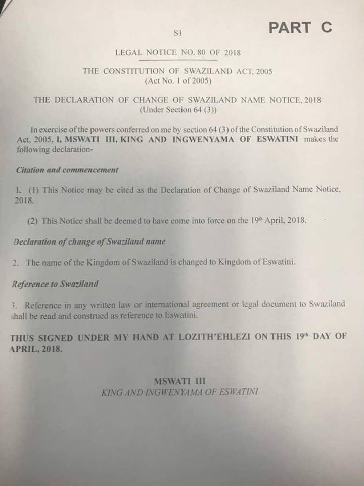
The change was apparently effective immediately: A purported copy of the legal order making the new name official, also dated April 19, was posted on a Swaziland news blog in May, with some validation from other sources.

Saturday, June 23, 2018

Syrian Civil War Map & Timeline: June 2018 (Subscription)

SUBSCRIBERS CLICK HERE TO PROCEED TO ARTICLE AND MAP

There are newer versions of this map available. To see them, view all Syria updates.

Research by Djordje Djukic. Map by onestopmap.com, Evan Centanni, and Djordje Djukic

Subscribe for full access to all conflict map reports!

Map of Syrian Civil War (Syria control map): Fighting and territorial control in Syria in June 2018 (Free Syrian Army rebels, Kurdish YPG, Syrian Democratic Forces (SDF), Hayat Tahrir al-Sham (HTS / Al-Nusra Front), Islamic State (ISIS/ISIL), and others). Includes Russia-Turkey-Iran agreed de-escalation zones and US deconfliction zone, plus recent locations of conflict and territorial control changes, such as Dashishah, Al Kara'a, and more. Colorblind accessible. Since late May, fighting between government and rebel forces in Syria has subsided, but battles against the so-called Islamic State (ISIS/ISIL) have continued in both eastern and western parts of the country.

See all this and more on the latest update to PolGeoNow's concise, professional Syrian Civil War control map, which includes a timeline of changes since our previous Syria map report in May, with sources cited.

This map and report are premium content, available to paid subscribers of the PolGeoNow Conflict Mapping Service.

Want to see before you subscribe? Check out our most recent FREE SAMPLE Syria map!

Exclusive map report includes:
  • Up-to-date illustration of current territorial control in Syria, color-coded for the Assad government, rebel groups, "Islamic State" (ISIS/ISIL) fighters, and the Kurdish-led Syrian Democratic Forces (SDF). Colorblind accessible.
  • Markers showing the approximate locations of Russian-Turkish-Iranian "de-escalation zones" and the one known US "deconfliction zone".
  • Special symbols indicating towns dominated by rebels of the former Al Qaeda Nusra Front (now Hayat Tahrir al-Sham or HTS) and by the Kurdish YPG militia (part of the US-backed SDF).
  • Detailed indication of city-by-city control, including key towns and other locations important to current events.
  • Locations of recent control changes and other important events, including Dashishah, Al Kara'a, Manbij, and more.
  • Detailed timeline of important events and changes to territorial control since May 23, 2018, compiled by our Syria-Iraq expert, with links to sources. 
  • Brief summary of the current situation and of major changes to the configuration of territorial boundaries and de facto enclaves and exclaves.

SUBSCRIBERS CLICK HERE TO PROCEED TO ARTICLE AND MAP

Not signed up yet? Click here to learn more about our professional subscription service!

Can I purchase just this map?
This map and report are not available for automated purchase to non-subscribers. If you need access or republication rights for only this map report, contact service@polgeonow.com for options.

Saturday, June 16, 2018

Yemen Control Map & Report - June 2018 (Subscription)

SUBSCRIBERS CLICK HERE TO PROCEED TO ARTICLE AND MAP

There are newer versions of this map available. To see them, view all Yemen articles on PolGeoNow.

Map of what is happening in Yemen as of June 16, 2018, including territorial control for the unrecognized Houthi government and former president Saleh's forces, president-in-exile Hadi and his allies in the Saudi-led coalition and Southern Movement, Al Qaeda in the Arabian Peninsula (AQAP), and the so-called Islamic State (ISIS/ISIL). Includes recent locations of fighting, including Hodeida, Al Faza, Al Tuhayata, and more. Colorblind accessible.
Subscribe for full access to all conflict map reports!

Timeline by Djordje Djukic. Map by Evan Centanni, Djordje Djukic, and onestopmap.com

Since April, Yemen's Saudi-led coalition has resisted increasing internal divisions to gain some ground against the rival Houthi government, as well as Al Qaeda forces in the east. Now, the coalition is making a concerted push to capture the Houthi-held city of Hodeida, Yemen's main port on the Red Sea.

See all this and more on the newest update to PolGeoNow's Yemen territorial control map, which includes a timeline of changes and important events since our previous Yemen map report in April.

This map and report are premium content available to paid subscribers of the PolGeoNow Conflict Mapping Service.

Want to see before you buy? Check out our most recent FREE SAMPLE Yemen map report!

Exclusive report includes:
  • Up-to-date map of current territorial control in Yemen, color-coded for the pro-Hadi coalition, Houthi/Saleh forces, Al Qaeda in the Arabian Peninsula (AQAP), and the so-called "Islamic State" (ISIS/ISIL).
  • Detailed indication of town-by-town control, including provincial boundaries, all major cities, and many smaller ones
  • Markers for recent areas of fighting, including Hodeida, Al Faza, Al Tuhayata, and more
  • Timeline of changes to the situation since April 14, 2018, with links to sources

SUBSCRIBERS CLICK HERE TO PROCEED TO ARTICLE AND MAP

Not a member yet? Click here to learn more about our professional subscription service!

Can I purchase just this map?
This map and report are not available for automated purchase to non-subscribers. If you need access or republication rights for only this map report, contact service@polgeonow.com for options.

Thursday, June 14, 2018

World Cup 2018: Which Countries Are (and Aren't) Members of FIFA?

There are newer versions of this explainer available. To see them, view all FIFA World Cup articles on PolGeoNow.

This is an updated edition of our FIFA member countries article for Russia 2018. The original version, from 2014, is here.

2018 world map showing the six continental confederations of men's national association football (soccer) teams, including all FIFA national teams and World Cup countries. Colorblind accessible.
The six continental confederations of national football teams associated with FIFA. Most, but not all, confederation members are individually members of FIFA as well. Map by Evan Centanni, based on work by EOZyo (source).
Around the world, fans of association football - also known in many countries as "soccer" - are tuning in today for the beginning of the month-long FIFA World Cup in Russia. Not all the world's countries can advance to the cup, but did they all get a shot at it? Which countries were eligible to enter the tournament, and which are excluded? Read on for our exclusive guide to the roster of FIFA national football teams...

Sunday, June 3, 2018

Somalia Control Map & Timeline - June 2018 (Subscription)

SUBSCRIBERS CLICK HERE TO PROCEED TO ARTICLE AND MAP

There are newer version of this map available. To see them, view all Somalia articles on PolGeoNow.

Map by onestopmap.com, Evan Centanni, and Djordje Djukic

Subscribe for full access to all conflict map reports!

Who controls Somalia? Map (2018). With states, regions, and territorial control. Best Somalia control map online, thoroughly researched and detailed but concise. Shows territorial control by Federal Government of Somalia (FGS), Al Shabaab, so-called Islamic State (ISIS/ISIL), separatist Somaliland, and autonomous states Puntland, Galmudug, and Khatumo (the ASWJ Sufi militia has merged with Galmudug state). Updated to June 2, 2018. Colorblind accessible.
In the last two months, several towns in southern Somalia have changed hands between Al Shabaab and government-allied forces, while political realignments have continued to change the country's map of autonomous states.

See all this and more on the latest update to PolGeoNow's concise, professional Somalia control map, which includes a timeline of changes since our previous Somalia map report of March 2018, with sources cited.

This map and report are premium content, available to paid subscribers of the PolGeoNow Conflict Mapping Service.

Want to see before you subscribe? Check out our most recent FREE SAMPLE Somalia map!

Exclusive map report includes:
  • Up-to-date illustration of current territorial control in Somalia, color-coded for the federal government coalition (including AMISOM peacekeepers), autonomous unionist forces, separatist Somaliland, Al Qaeda affiliate Al Shabaab, and fighters aligned to the so-called "Islamic State" (ISIS/ISIL). Areas of lawlessness or unclear control indicated separately. Colorblind accessible.
  • Boundaries and labels for Somalia's official regions, plus control lines for the autonomous administrations of Somaliland, Puntland, Galmudug, and Khatumo.
  • Detailed indication of city-by-city control, including many relevant smaller towns and villages.
  • Locations of recent fighting and other important events, including Tukaraq, Moqokori, Bulo Haji, Bali Khadar, and more.
  • Detailed timeline of territorial control changes and key political developments since March 28, 2018, with sources indicated. 
  • Brief summary of the conflict situation, as well as major changes to the alignment of autonomous administrations, over the past three months.

SUBSCRIBERS CLICK HERE TO PROCEED TO ARTICLE AND MAP

Not signed up yet? Click here to learn more about our professional subscription service!