 |
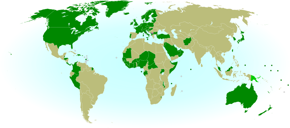
| Countries recognizing the Republic of Kosovo in green, highlighting recent additions. Disputed recognitions in yellow. Kosovo in magenta. Map by Evan Centanni, modified from public domain graphic (source). |
Updates on the world's countries and borders
Showing posts with label unrecognized. Show all posts
Showing posts with label unrecognized. Show all posts
Friday, October 24, 2014
Map Update: Kosovo Now Recognized by Every Country in Oceania (107/193 UN members)
Premium members click here to view this article in the ad-free members area. Not a member yet? Subscribe now!
Tuesday, October 14, 2014
Map: "Eurasian Union" Gets New Member
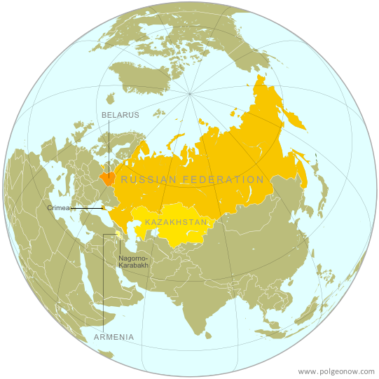 |
| The Eurasian Economic Union's four member countries, plus disputed territories that might be officially or unofficially included. Map by Evan Centanni, starting from this map by Keverich2. License: CC BY-SA |
Thursday, July 24, 2014
Map Update: Kosovo Recognized by 3 More Countries in 2014 (106/193)
Premium members click here to view this article in the ad-free members area. Not a member yet? Subscribe now!
 |
| Countries recognizing the Republic of Kosovo in green, highlighting recent additions. Disputed recognitions in yellow. Kosovo in magenta. Map by Evan Centanni, modified from public domain graphic (source). |
Sunday, June 8, 2014
Palestine: West Bank and Gaza Reunited Under Transitional Government
(Keep up with changes to Palestine's situation: view all Palestine updates.)
Premium members click here to view this article in the ad-free members area. Not a member yet? Subscribe now!
By Evan Centanni
Unity Government
The partially-unrecognized State of Palestine is not only divided between Palestinian and Israel control - even the Palestinian-administered areas have been governed separately for several years now. However, this month rival parties Hamas and Fatah have finally come together to reunite the West Bank and Gaza Strip under a single Palestinian government.
Divided Country
The rift in control opened up in 2007, after religious militant group Hamas won a majority of seats in the 2006 Palestinian legislative elections. Hamas and Fatah, the current ruling party at the time, failed to form a stable unity government then, and the conflict between them escalated into a short civil war in the Gaza Strip.
See Also: Is Palestine Really a Country?
 |
| Control zones based on the Oslo Accords. Area A: Palestinian control; Area B: mixed Israeli-Palestinian control; Area C: full Israeli control. Map by Evan Centanni (sources: Natural Earth, B'Tselem, U.N. OCHA oPt). |
By Evan Centanni
Unity Government
The partially-unrecognized State of Palestine is not only divided between Palestinian and Israel control - even the Palestinian-administered areas have been governed separately for several years now. However, this month rival parties Hamas and Fatah have finally come together to reunite the West Bank and Gaza Strip under a single Palestinian government.
Divided Country
The rift in control opened up in 2007, after religious militant group Hamas won a majority of seats in the 2006 Palestinian legislative elections. Hamas and Fatah, the current ruling party at the time, failed to form a stable unity government then, and the conflict between them escalated into a short civil war in the Gaza Strip.
See Also: Is Palestine Really a Country?
Thursday, March 27, 2014
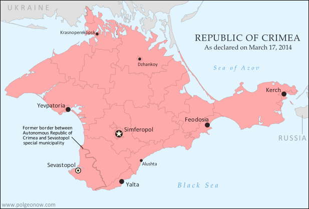
Crimea Joins Russia, Gives Up Independence, Becomes Disputed Territory
Premium members click here to view this article in the ad-free members area. Not a member yet? Subscribe now!
By Evan Centanni
Russia Annexes Crimea
The Crimean peninsula, which declared independence from Ukraine ten days ago as the Republic of Crimea, has now been absorbed into Russia. This was part of the plan all along - the claimed Republic of Crimea had requested to join Russia at the same time that it declared independence.
Related: Complete Map of Locations Seized by Russia in Crimea (Premium)
 |
The claimed Republic of Crimea which has now joined Russia (click to see full-sized map). By Evan Centanni, based on this blank map.
|
Russia Annexes Crimea
The Crimean peninsula, which declared independence from Ukraine ten days ago as the Republic of Crimea, has now been absorbed into Russia. This was part of the plan all along - the claimed Republic of Crimea had requested to join Russia at the same time that it declared independence.
Related: Complete Map of Locations Seized by Russia in Crimea (Premium)
Tuesday, March 18, 2014
Crimea Declares Independence: Is It Really a Country?
On Monday, two regional governments on the Crimean Peninsula controversially declared their independence from Ukraine as the new Republic of Crimea. While the declaration has been rejected by most of the world community, and Crimea hopes to swiftly unite with Russia, for now it might be considered a de facto sovereign state. Read on for details.
Premium members click here to view this article in the ad-free members area. Not a member yet? Subscribe now!
By Evan Centanni
Declaration of Independence
Following Ukraine's revolution, the explosion of pro-Russian protests in the east, and the subsequent occupation of the Crimean peninsula by Russian forces (see our premium report, Ukraine Map: Occupations, Autonomy, & Invasion), a new independent country has been declared on the coast of the Black Sea.
 |
| The Republic of Crimea. Map by Evan Centanni, based on this blank map. |
Declaration of Independence
Following Ukraine's revolution, the explosion of pro-Russian protests in the east, and the subsequent occupation of the Crimean peninsula by Russian forces (see our premium report, Ukraine Map: Occupations, Autonomy, & Invasion), a new independent country has been declared on the coast of the Black Sea.
Friday, November 1, 2013
Map: Palestine Recognized by Two More Countries (134/193)
(Keep up with changes to Palestine's situation: view all Palestine updates.)
 |
| Countries recognizing the State of Palestine in green, with most recent additions highlighted. Palestine in magenta (circled). Click to enlarge. Map by Evan Centanni, modified from public domain graphic (source). |
Friday, October 25, 2013
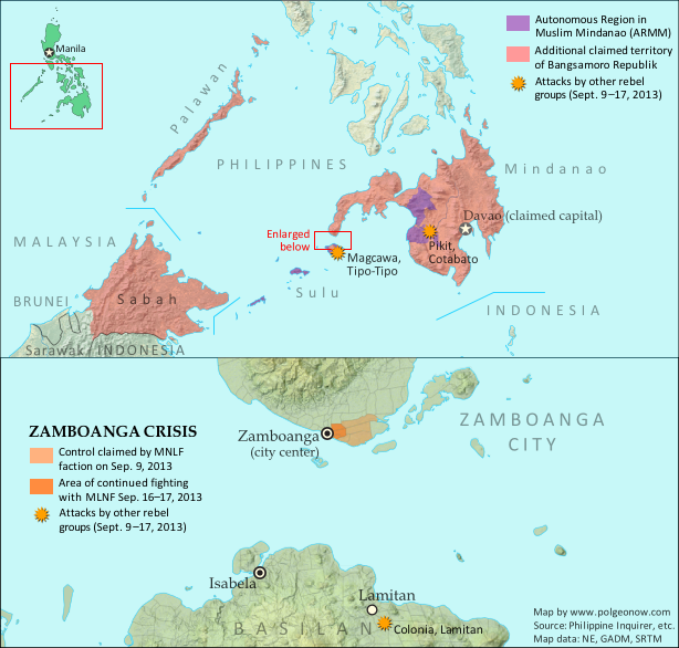
No More Bangsamoro Republik: Philippine Rebel Occupation Defeated
 |
Claims and territorial control of the MNLF rebels and Bangsamoro Republik during last month's crisis. Click to see full-sized map and article. Map by Evan Centanni.
|
Last month, Political Geography Now mapped Moro rebel control in the Philippines' Zamboanga crisis. The rebels, drawn from a group which had declared independence from the Philippines as the Bangsamoro Republik, had occupied several neighborhoods of Zamboanga City in the country's southwest after an aborted attempt to raise their flag in the city center.
Ten days after we published that article, the government of the Philippines declared the crisis over, with all hostages freed and only scattered fighting occurring over the next two days as the surviving rebels attempted to escape the area. After nearly three weeks of chaos, the city of Zamboanga was once again fully under government control.
What of the MNLF fighters?
Though hundreds of rebels from the Moro National Liberation Front (MNLF) were killed in the fighting, some did escape, and the attack's commander Habier Malik is still missing. Nur Misuari, the faction's leader and founder of the self-declared Bangsamoro Republik, was not present at the attack but is now wanted on charges of rebellion. But he may have more than just the government to worry about - Malik's surviving men from the Zamboanga attack are also said to be on the hunt for Misuari, who allegedly tricked them into participating. According to Mujiv Hataman, governor of the officially sanctioned Autonomous Region in Muslim Mindanao (ARMM), Misuari promised Malik's men that U.N. peacekeepers would arrive soon after the attack to secure Bangsamoro independence and reward each fighter with 10,000 pesos (US $230) and a new weapon.
BIFF Attacks
Attacks by other Moro rebel groups in nearby regions continued until just after Zamboanga was secured. In particular, the Bangsamoro Islamic Freedom Fighters (BIFF), a splinter group from the Moro Islamic Liberation Fighters (MILF) who are currently in peace talks with the Philippine government, continued launching attacks elsewhere in Mindanao into early October. The BIFF is not closely tied to Nur Misuari's MNLF, and these were apparently just opportunistic attacks taking advantage of the military's distraction during the crisis in Zamboanga.
More information: Bangsamoro Republik? Philippine Separatists Seize Territory (map)
Thursday, October 17, 2013
Map Update: Kosovo Recognized by 3 More Countries (103/193)
 |
| Countries recognizing the Republic of Kosovo in green, highlighting recent additions. Disputed recognitions in yellow. Kosovo in magenta. Map by Evan Centanni, modified from public domain graphic (source). |
Tuesday, September 17, 2013
Bangsamoro Republik? Philippine Separatists Seize Territory (map)
Zamboanga City in the southwestern Philippines came under rebel attack last week, with insurgents seizing and occupying several neighborhoods. Because the fighters are from a rebel group that declared independence in August, their newfound territorial control might technically be considered the birth of a new breakaway state. Details and discussion below!
 |
Claims and territorial control of the MNLF rebels/Bangsamoro Republik. Map by Evan Centanni.
|
Thursday, September 5, 2013
Lies Your World Map Told You: 5 Ways You're Being Misled
Unfortunately, most world political maps aren't telling you the whole story. The idea that Earth's land is cleanly divvied up into nation-states - one country for each of the world's peoples - is more an imaginative ideal than a reality. Read on to learn about five ways your map is lying to you about borders, territories, and even the roster of the world's countries.
 |
The lines and coloring on this map are hiding major truths about the world's countries.
(Source: U.S. CIA; public domain) |
Thursday, August 15, 2013
Map: Kosovo Recognized by 4 More Countries (101/193)
 |
| Countries recognizing the Republic of Kosovo in green, with the four most recent additions highlighted. Disputed recognitions in yellow. Kosovo in magenta. Map by Evan Centanni, modified from public domain graphic (source). |
Thursday, May 9, 2013
Who Recognizes Palestine in 2013?
(Keep up with changes to Palestine's situation: view all Palestine updates.)
Palestine is now an Observer State in the U.N., but it's still not recognized individually by all U.N. member countries. Read on for more about the latest countries to recognize Palestine, plus other recent changes to its international status.
Palestine is now an Observer State in the U.N., but it's still not recognized individually by all U.N. member countries. Read on for more about the latest countries to recognize Palestine, plus other recent changes to its international status.
 |
| Countries recognizing the State of Palestine in green, with most recent additions highlighted in lighter green. Palestine in magenta (circled). Map by Evan Centanni, modified from public domain graphic (source). |
Saturday, April 20, 2013
North Kosovo Status Changing After Serbia Deal
 |
| Map by Evan Centanni, based on these two blank maps by Nord-NordWest. License: CC BY-SA |
Serbia and the breakaway Republic of Kosovo reached a landmark deal on Friday to normalize their relations, partially compromising on several contentious issues between the two governments in southeastern Europe. Kosovo declared its independence from Serbia in 2008, but due to Serbia's opposition it has still not achieved full international recognition.
Status Change for North Kosovo
North Kosovo is the largest of several areas within Kosovo where the majority of people are part of the Serb ethnic group, whereas 90% of people in Kosovo as a whole are ethnically Albanian. When Kosovo split from Serbia, many Serbs in the north refused to go, governing themselves separately from Kosovo and choosing instead to continue cooperating with and accepting government funding from Serbia.
Friday, April 5, 2013
Kosovo Recognition Update: April 2013 (99/193)
 |
| Countries recognizing the Republic of Kosovo in green, with the two most recent additions highlighted. Disputed recognitions in yellow. Kosovo in magenta. Map by Evan Centanni, modified from public domain graphic (source). |
Thursday, December 20, 2012
Kosovo Now Recogized by Half of U.N. (97/193)
 |
| Countries recognizing the Republic of Kosovo in green, with the five most recent additions to the list labelled. Kosovo in magenta. Map by Evan Centanni, modified from public domain graphic (source). |
Thursday, December 6, 2012
Is Palestine Really a Country?
(Keep up with changes to Palestine's situation: view all Palestine updates.)
Palestine is now recognized as a country by both the U.N. and a majority of its members, but many have questioned whether this new-found status reflects the truth on the ground. Is Palestine really an independent country, or is this a political fantasy concocted by supporters in the U.N.?
What is a "sovereign state"?
By the most common definition, a "state" has to have:
A prospective country that fits these criteria is described by geographers as a de facto sovereign state, even if it's not recognized by the international community (de facto is Latin for "in actual fact").
Palestine is now recognized as a country by both the U.N. and a majority of its members, but many have questioned whether this new-found status reflects the truth on the ground. Is Palestine really an independent country, or is this a political fantasy concocted by supporters in the U.N.?
 |
| The Olso Accords divided the Palestinian territories into three areas of control (see article for explanation). Map by Evan Centanni. Sources: Natural Earth, B'Tselem, U.N. OCHA oPt. |
By the most common definition, a "state" has to have:
- A government
- A defined territory
- A permanent population
- The ability to conduct foreign relations with other states
A prospective country that fits these criteria is described by geographers as a de facto sovereign state, even if it's not recognized by the international community (de facto is Latin for "in actual fact").
Friday, November 30, 2012
Palestine Recognized as a Country by the U.N.
(Keep up with changes to Palestine's situation: view all Palestine updates.)
This Thursday, the U.N. General Assembly voted to change Palestine's status in the organization from "observer" to "observer state". This is the first time the international body has recognized Palestine as a state, giving it the same status enjoyed by U.N. non-member Vatican City.
Until this Thursday, Palestine was a partially recognized country, acknowledged by some U.N. member nations, but not by the U.N. itself (See also: How many countries are there in the world?). Although its delegation has had observer status at the U.N. since 1974, it was never classified as a "state", being treated as something between a country and a non-government organization. Now, the organization has officially voted to change Palestine's status to "observer state" - effectively a recognition that it's an independent country, even though it's still not a U.N. member.
The Palestinian delegation campaigned to join the U.N. as a member last year, but had to give up after the U.S. promised to veto the application in the U.N. Security Council. Observer status, on the other hand, is determined by a majority vote in the U.N. General Assembly, which no single country can veto. That vote happened on November 29th, with members voting 138 to 9 in favor of granting Palestine observer state status (41 members abstained, and 5 were absent from the vote; see the full breakdown of national votes).
This Thursday, the U.N. General Assembly voted to change Palestine's status in the organization from "observer" to "observer state". This is the first time the international body has recognized Palestine as a state, giving it the same status enjoyed by U.N. non-member Vatican City.
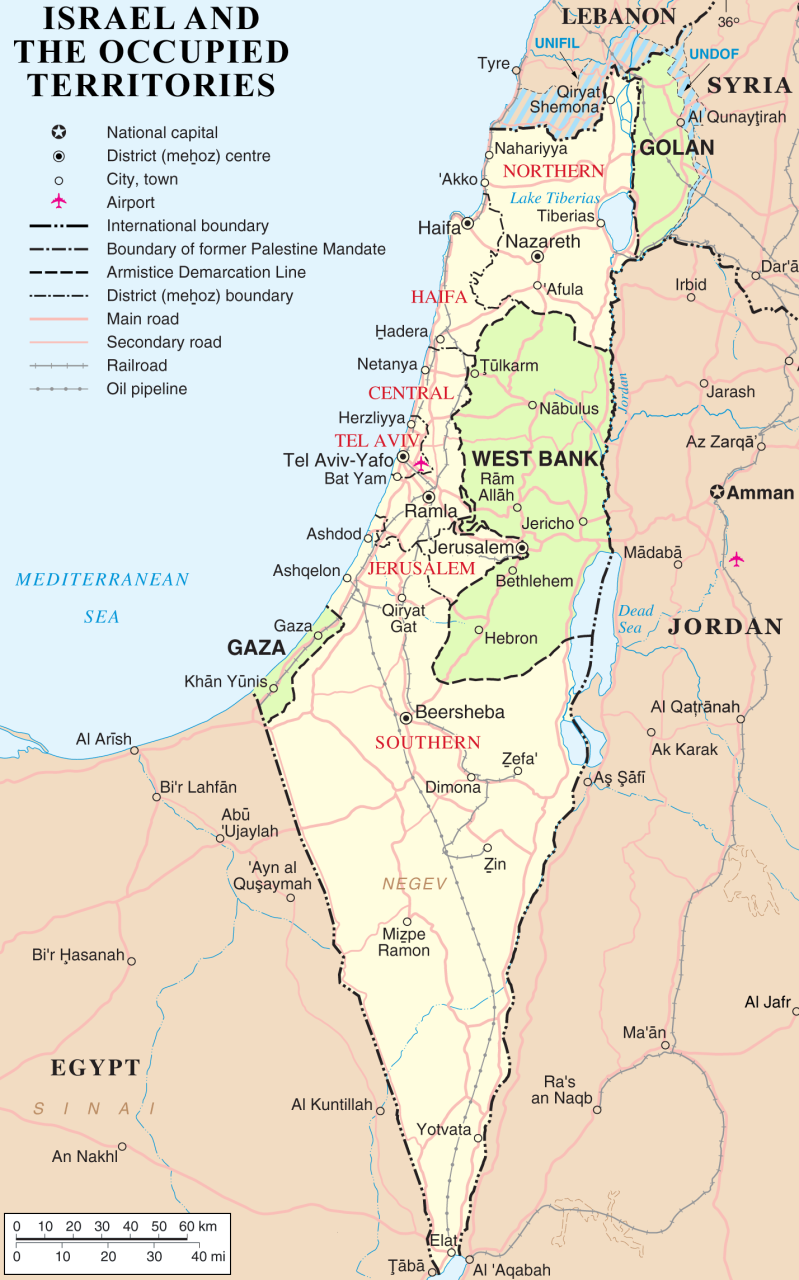 |
| The State of Palestine claims the West Bank and Gaza, which are largely occupied by Israel. The Golan Heights are not part of the Palestinian Territories. Public domain map (source). |
The Palestinian delegation campaigned to join the U.N. as a member last year, but had to give up after the U.S. promised to veto the application in the U.N. Security Council. Observer status, on the other hand, is determined by a majority vote in the U.N. General Assembly, which no single country can veto. That vote happened on November 29th, with members voting 138 to 9 in favor of granting Palestine observer state status (41 members abstained, and 5 were absent from the vote; see the full breakdown of national votes).
Thursday, October 18, 2012
Kosovo Recognized by Papua New Guinea (92/193)
 |
| Countries recognizing the Republic of Kosovo in green, with the most recent, Papua New Guinea (lower right), in lighter green. Kosovo in magenta. Map by Evan Centanni, modified from public domain graphic (source). |
Thursday, September 6, 2012
Independent Azawad No More: Northern Mali in Islamist Hands
There are newer versions of this map available. To see them, view all Mali maps.
Since declaring the independence of Azawad in April, control by northern Mali's MNLA rebels has been usurped by the hardline Islamists of Ansar Dine and MUJAO. The new regime, while still bitter enemies of the Malian government, does not claim independence. Presented here is a map and brief guide explaining the current situation.
Separatists vs. Islamists
Last April, the Tuareg-dominated separatists of the National Movement for the Liberation of Azawad (MNLA) swept into victory in northern Mali, completing their control of the region and declaring independence as the State of Azawad. But their victory was won only with the support of Ansar Dine, an Islamist militia led by veteran Tuareg fighter Iyad Ag Ghaly. The MNLA and Ansar Dine then alternated between cooperation and conflict for months, with the Islamists grabbing ever more control of the region's cities.
Since declaring the independence of Azawad in April, control by northern Mali's MNLA rebels has been usurped by the hardline Islamists of Ansar Dine and MUJAO. The new regime, while still bitter enemies of the Malian government, does not claim independence. Presented here is a map and brief guide explaining the current situation.
 |
Area held by Islamist rebel groups Ansar Dine and MUJWA in northern Mali. Map by Evan Centanni, modified from Wikimedia map by Orionist, using images by Carport and NordNordWest (source). License: CC BY-SA.
|
Last April, the Tuareg-dominated separatists of the National Movement for the Liberation of Azawad (MNLA) swept into victory in northern Mali, completing their control of the region and declaring independence as the State of Azawad. But their victory was won only with the support of Ansar Dine, an Islamist militia led by veteran Tuareg fighter Iyad Ag Ghaly. The MNLA and Ansar Dine then alternated between cooperation and conflict for months, with the Islamists grabbing ever more control of the region's cities.
Subscribe to:
Posts (Atom)