Showing posts with label the "islamic state". Show all posts

Monday, November 20, 2017

Philippines: No More "Islamic State" Control in Marawi

Article by Evan Centanni

(Subscribers click here to view this article in the members area.)

Map of so-called Islamic State (ISIS/ISIL) control in the Philippines, during the May-June 2017 crisis involving the Maute group and Abu Sayyaf takeover of Marawi Ciy, Lanao del Sur province, Mindanao. Updated to June 4, 2017, shows detailed control of Marawi by barangay. Includes map of area affected by martial law declared by President Rodrigo Duterte. Colorblind accessible.

Rebel Takeover in Southern Philippines

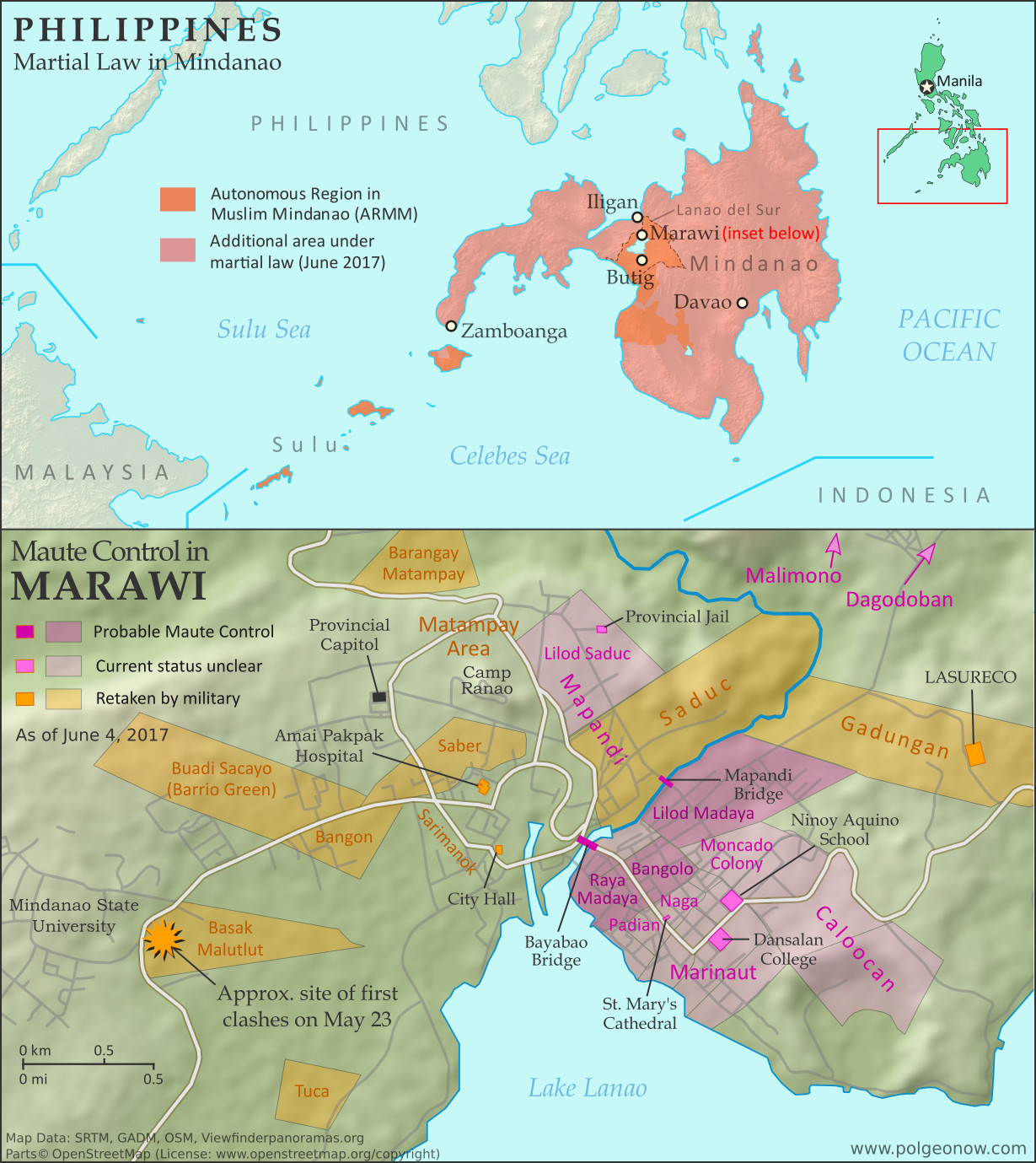
In early June, we published a detailed map and timeline of control in the Filipino city of Marawi, which had been partly captured by rebel fighters claiming to representing the so-called "Islamic State" (IS; formerly ISIS/ISIL). In a matter of hours, hundreds of religious hardline fighters had launched a surprise takeover of the city, led by the recently-formed Maute rebel group and Isnilon Hapilon, a leader of the radical Abu Sayyaf network and the IS's officially designated leader for the Philippines.

The Filipino military quickly moved in to expel the fighters from Marawi, but the battle would drag on for another 5 months before the city was restored to full government control. As part of the government response, President Rodrigo Duterte declared martial law across the entire southern Philippines. For more on the history of martial law in the Philippines, and rebellions in the country's south, see our article from June.

Wednesday, November 15, 2017

Syrian Civil War Map & Timeline: "Islamic State" Exits Last Major City - November 2017 (Subscription)

SUBSCRIBERS CLICK HERE TO PROCEED TO ARTICLE AND MAP

There are newer versions of this map available. To see them, view all Syria updates.

Research by Djordje Djukic. Map by onestopmap.com, Evan Centanni, and Djordje Djukic

Subscribe for full access to all conflict map reports!

Map of Syrian Civil War (Syria control map): Fighting and territorial control in Syria in November 2017 (Free Syrian Army rebels, Kurdish YPG, Syrian Democratic Forces (SDF), Jabhat Fateh al-Sham / Hayat Tahrir al-Sham (Al-Nusra Front), Islamic State (ISIS/ISIL), and others). Includes Russia-Turkey-Iran agreed de-escalation zones and US deconfliction zone, plus recent locations of conflict and territorial control changes, such as Deir ez-Zor, Abu Kamal (Al Bukamal), Markadeh, Quriyah, and more. Colorblind accessible.Over the past few weeks, the so-called "Islamic State" (ISIS/ISIL) has been completely driven out of its last major city, Deir ez-Zor, and now only controls a few smaller towns and the surrounding desert. Its enemies, the Russia-backed Syrian government and the US-backed Syrian Democratic Forces (SDF), are both moving in to take its place.

See all this and more on the latest update to PolGeoNow's concise, professional Syrian Civil War control map, which includes a timeline of changes since our previous Syria map report in October, with sources cited.

This map and report are premium content, available to paid subscribers of the PolGeoNow Conflict Mapping Service.

Want to see before you subscribe? Check out our most recent FREE SAMPLE Syria map!

Exclusive map report includes:
  • Up-to-date illustration of current territorial control in Syria, color-coded for the Assad government, rebel groups, "Islamic State" (ISIS/ISIL) fighters, and Kurdish/SDF forces. Colorblind accessible.
  • Markers showing the approximate locations of Russian-Turkish-Iranian "de-escalation zones" and the one known US "deconfliction zone".
  • Special symbols indicating towns dominated by rebels of the former Al Qaeda Nusra Front (now Hayat Tahrir al-Sham) and US-backed Syrian Democratic Forces (SDF).
  • Detailed indication of city-by-city control, including key towns and other locations important to current events.
  • Locations of recent fighting and other important events, including Deir ez-Zor, Abu Kamal (Al Bukamal), Markadeh, Quriyah, and more.
  • Detailed timeline of important events and changes to territorial control since October 26, 2017, compiled by our Syria-Iraq expert, with links to sources.

SUBSCRIBERS CLICK HERE TO PROCEED TO ARTICLE AND MAP

Not signed up yet? Click here to learn more about our professional subscription service!

Can I purchase just this map?
This map and report are not available for automated purchase to non-subscribers. If you need access or republication rights for only this map report, contact service@polgeonow.com for options.

Thursday, October 26, 2017

Syrian Civil War Map & Timeline: SDF Captures Raqqah - October 2017 (Subscription)

SUBSCRIBERS CLICK HERE TO PROCEED TO ARTICLE AND MAP

There are newer versions of this map available. To see them, view all Syria updates.

Research by Djordje Djukic. Map by onestopmap.com, Evan Centanni, and Djordje Djukic

Subscribe for full access to all conflict map reports!

Map of Syrian Civil War (Syria control map): Fighting and territorial control in Syria in October 2017 (Free Syrian Army rebels, Kurdish YPG, Syrian Democratic Forces (SDF), Jabhat Fateh al-Sham / Hayat Tahrir al-Sham (Al-Nusra Front), Islamic State (ISIS/ISIL), and others). Includes Russia-Turkey-Iran agreed de-escalation zones and US deconfliction zone, plus recent locations of conflict and territorial control changes, such as Deir ez-Zor, Maadan, As Suwar, Aqerabat, and more. Colorblind accessible. In the past month, the so-called "Islamic State" (IS; formerly ISIS/ISIL) has lost its former capital city and other key sites to the US-backed Syrian Democratic Forces (SDF), even as government troops have advanced against it in Deir ez-Zor, Hama, and Homs provinces.

See all this and more on the latest update to PolGeoNow's concise, professional Syrian Civil War control map, which includes a timeline of changes since our previous Syria map report in September, with sources cited.

This map and report are premium content, available to paid subscribers of the PolGeoNow Conflict Mapping Service.

Want to see before you subscribe? Check out our most recent FREE SAMPLE Syria map!

Exclusive map report includes:
  • Up-to-date illustration of current territorial control in Syria, color-coded for the Assad government, rebel groups, "Islamic State" (ISIS/ISIL) fighters, and Kurdish/SDF forces. Colorblind accessible.
  • Markers showing the approximate locations of Russian-Turkish-Iranian "de-escalation zones" and the one known US "deconfliction zone".
  • Special symbols indicating towns dominated by rebels of the former Al Qaeda Nusra Front (now Hayat Tahrir al-Sham) and US-backed Syrian Democratic Forces (SDF).
  • Detailed indication of city-by-city control, including key towns and other locations important to current events.
  • Locations of recent fighting and other important events, including Raqqah, Deir ez-Zor, Mayadin (Mayadeen), As Suwar, the Al Omar oil field, and more.
  • Detailed timeline of important events and changes to territorial control since September 27, 2017, compiled by our Syria-Iraq expert, with links to sources.

SUBSCRIBERS CLICK HERE TO PROCEED TO ARTICLE AND MAP

Not signed up yet? Click here to learn more about our professional subscription service!

Can I purchase just this map?
This map and report are not available for automated purchase to non-subscribers. If you need access or republication rights for only this map report, contact service@polgeonow.com for options.

Monday, October 16, 2017

Iraq Control Map & Timeline: Government Takes Kirkuk from Kurdistan - October 2017

There are newer versions of this map available. To see them, view all Iraq updates.

Detailed map of territorial control in Iraq as of October 16, 2017 after the recapture of Hawija and Tal Afar and government seizure of Kirkuk. including territory held by the so-called Islamic State (ISIS, ISIL), the Baghdad government, the Kurdistan Peshmerga, and the Yezidi Sinjar Alliance (YBS and YJE). Colorblind accessible.
Basemap by Koen Adams of onestopmap.com, with territorial control by Evan Centanni and Djordje Djukic. All rights reserved.
(Subscribers click here to view this article in the member area)

Timeline by Djordje Djukic

Summary of Events
Since our previous Iraq control map update in late July, there have been big changes to territorial control in Iraq, all involving expansions of control for the Iraqi military and its close allies (mainly police and Iran-backed militias): The so-called "Islamic State" (IS; formerly ISIS/ISIL) has been driven out of its Tal Afar and Hawija enclaves, and the disputed city of Kirkuk has been retaken from Kurdish forces in response to the controversial Kurdistan independence referendum. Iraqi government forces have also begun to chip away at the remaining swath of IS territory in the countryside of Anbar province, capturing the town of Anah on the road to the Syrian border.

Thursday, September 28, 2017

Syrian Civil War Map & Timeline: Siege of Deir ez-Zor Broken - September 2017 (Subscription)

SUBSCRIBERS CLICK HERE TO PROCEED TO ARTICLE AND MAP

There are newer versions of this map available. To see them, view all Syria updates.

Research by Djordje Djukic. Map by onestopmap.com, Evan Centanni, and Djordje Djukic

Subscribe for full access to all conflict map reports!

Map of Syrian Civil War (Syria control map): Fighting and territorial control in Syria in September 2017 (Free Syrian Army rebels, Kurdish YPG, Syrian Democratic Forces (SDF), Jabhat Fateh al-Sham / Hayat Tahrir al-Sham (Al-Nusra Front), Islamic State (ISIS/ISIL), and others). Includes Russia-Turkey-Iran agreed de-escalation zones and US deconfliction zone, plus recent locations of conflict and territorial control changes, such as Deir ez-Zor, Maadan, As Suwar, Aqerabat, and more. Colorblind accessible. In the past month, the territory of the so-called "Islamic State" (IS; formerly ISIS/ISIL) has continued to shrink rapidly, with the Russia-backed Assad government and the US-backed Syrian Democratic Forces (SDF) both rushing to secure Deir ez-Zor province in Syria's east.

See all this and more on the latest update to PolGeoNow's concise, professional Syrian Civil War control map, which includes a timeline of changes since our previous Syria map report in August, with sources cited.

This map and report are premium content, available to paid subscribers of the PolGeoNow Conflict Mapping Service.

Want to see before you subscribe? Check out our most recent FREE SAMPLE Syria map!

Exclusive map report includes:
  • Up-to-date illustration of current territorial control in Syria, color-coded for the Assad government, rebel groups, "Islamic State" (ISIS/ISIL) fighters, and Kurdish/SDF forces. Colorblind accessible.
  • Markers showing the approximate locations of Russian-Turkish-Iranian "de-escalation zones" and the one known US "deconfliction zone".
  • Special symbols indicating towns dominated by rebels of the former Al Qaeda Nusra Front (now Hayat Tahrir al-Sham) and US-backed Syrian Democratic Forces (SDF).
  • Detailed indication of city-by-city control, including key towns and other locations important to current events.
  • Locations of recent fighting and other important events, including Deir ez-Zor, Maadan, As Suwar, Aqerabat, and more.
  • Detailed timeline of important events and changes to territorial control since August 28, 2017, compiled by our Syria-Iraq expert, with links to sources.

SUBSCRIBERS CLICK HERE TO PROCEED TO ARTICLE AND MAP

Not signed up yet? Click here to learn more about our professional subscription service!

Can I purchase just this map?
This map and report are not available for automated purchase to non-subscribers. If you need access or republication rights for only this map report, contact service@polgeonow.com for options.

Friday, September 22, 2017

Referendum 2017: Iraqi Kurdistan Map

Two of the world's autonomous regions are about to vote in controversial independence referendums. Iraqi Kurdistan decides on independence from Iraq this Monday, and on October 1 Catalonia plans to vote on leaving Spain. PolGeoNow will be covering these events with a series of articles, but in the meantime we couldn't wait to share our new Iraqi Kurdistan map with you!

Map of Iraq and Kurdistan's place within it, published in advance of the 2017 Iraqi Kurdistan independence referendum. Includes disputed territories and territorial control as of July 30, 2017. Colorblind accessible.
Graphic by Evan Centanni and Djordje Djukic, incorporating base map by Koen Adams of onestopmap.com. All rights reserved.

Iraqi Kurdistan Independence Referendum

The Kurdistan Region of Iraq (Iraqi Kurdistan for short) is just part of the traditional homeland of the Kurds, the Middle East's fourth-largest ethnic group after Arabs, Persians, and Turks.

Many Kurds also live in Turkey, Syria, and Iran. But Iraqi Kurdistan is where they have the most legal rights, governing themselves in what's internationally recognized as an autonomous region within Iraq.

But all's not well in Kurdistan-Iraq relations. Iraqi Kurds suffered through horrific violence and persecution in the 1980s and 90s, and now the region's top politician has staked his reputation on separating Kurdistan from Iraq permanently.

Thursday, September 21, 2017

Libya Control Map & Timeline - September 2017 (Subscription)

SUBSCRIBERS CLICK HERE TO PROCEED TO ARTICLE AND MAP

There are newer versions of this map available. To see them, view all Libya updates.

Research by Djordje Djukic. Map by onestopmap.com, Evan Centanni, and Djordje Djukic.

Subscribe for full access to all conflict map reports!

Libya control map: Shows detailed territorial control in Libya's civil war as of September 2017, including all major parties (Government of National Accord (GNA); Tobruk House of Representatives, General Haftar's Libyan National Army (LNA), and allies; Tuareg and Toubou (Tebu) militias in the south; the so-called Islamic State (ISIS/ISIL); and other groups such as the National Salvation Government(NSG) and hardline religious groups). Now includes terrain and major roads. Colorblind accessible. Since our previous Libya control map update in June, the Libyan National Army (LNA), fighting on behalf of the country's eastern government, has completed its years-long campaign to secure control of Benghazi from religious hardline fighters. Meanwhile, with the UN-backed government in Tripoli distracted by fighting with a third faction (the "National Salvation Government", or NSG), the so-called "Islamic State" (IS; formerly ISIS/ISIL) has begun a resurgence in rural areas near its one-time stronghold of Sirte.

See all this and more on the latest update to PolGeoNow's concise, professional Libyan Civil War control map, which comes with a timeline of changes since our June 2017 Libya control map report.

This map and report are premium content available to paid subscribers of the PolGeoNow Conflict Mapping Service.

Want to see before you subscribe? Check out our most recent FREE SAMPLE Libya map!

Exclusive report includes:
  • Up-to-date map of current territorial control in Libya, color-coded for the UN-backed Government of National Accord (GNA), the rival Tobruk parliament and Khalifa Haftar's Libyan National Army (LNA), and the so-called "Islamic State" (ISIS/ISIL). New colors have been added for the Tuareg and Toubou ethnic alliances that control much of the country's far south.
  • Detailed indication of city-by-city control, including key towns and other locations important to current events.
  • Locations of recent fighting and military operations, including Wadi al-Ahmar, Nawfaliya, Benghazi, Sabratha, and more.
  • Detailed timeline of important events and changes to territorial control since June 6, 2017, with links to all sources.

SUBSCRIBERS CLICK HERE TO PROCEED TO ARTICLE AND MAP

Not signed up yet? Click here to learn more about our professional subscription service!

Can I purchase just this map?
This map and report are not available for automated purchase to non-subscribers. If you need access or republication rights for only this map report, contact service@polgeonow.com for options.

Wednesday, August 30, 2017

Syrian Civil War Map & Timeline - August 2017 (Subscription)

SUBSCRIBERS CLICK HERE TO PROCEED TO ARTICLE AND MAP

There are newer versions of this map available. To see them, view all Syria updates.

Research by Djordje Djukic. Map by onestopmap.com, Evan Centanni, and Djordje Djukic

Subscribe for full access to all conflict map reports!

Map of Syrian Civil War (Syria control map): Fighting and territorial control in Syria in August 2017 (Free Syrian Army rebels, Kurdish YPG, Syrian Democratic Forces (SDF), Jabhat Fateh al-Sham / Hayat Tahrir al-Sham (Al-Nusra Front), Islamic State (ISIS/ISIL), and others). Includes Russia-Turkey-Iran agreed de-escalation zones and US deconfliction zone, plus recent locations of conflict and territorial control changes, such as Raqqah, Maadan, Suknah, al-Koum, and more. Colorblind accessible. In the past month, the so-called "Islamic State" (ISIS/ISIL) has lost vast swaths of territory in the center of Syria to government forces, leaving the western end of its main territory completely surrounded. Meanwhile, Syrian and Lebanese forces have cleared out ISIS and hardline rebel forces who controlled areas along both sides of the border with Lebanon.

See all this and more on the latest update to PolGeoNow's concise, professional Syrian Civil War control map, which includes a timeline of changes since our previous Syria map report in July, with sources cited.

This map and report are premium content, available to paid subscribers of the PolGeoNow Conflict Mapping Service.

Want to see before you subscribe? Check out our most recent FREE SAMPLE Syria map!

Exclusive map report includes:
  • Up-to-date illustration of current territorial control in Syria, color-coded for the Assad government, rebel groups, "Islamic State" (ISIS/ISIL) fighters, and Kurdish/SDF forces. Colorblind accessible.
  • Markers showing the approximate locations of Russian-Turkish-Iranian "de-escalation zones" and the one known US "deconfliction zone".
  • Special symbols indicating towns dominated by rebels of the former Nusra Front (now Hayat Tahrir al-Sham) and US-backed Syrian Democratic Forces (SDF).
  • Detailed indication of city-by-city control, including key towns and other locations important to current events.
  • Locations of recent fighting and other important events, including Raqqah, Maadan, Suknah, al-Koum, and more.
  • Detailed timeline of important events and changes to territorial control since July 21, 2017, compiled by our Syria-Iraq expert, with links to sources.

SUBSCRIBERS CLICK HERE TO PROCEED TO ARTICLE AND MAP

Not signed up yet? Click here to learn more about our professional subscription service!

Can I purchase just this map?
This map and report are not available for automated purchase to non-subscribers. If you need access or republication rights for only this map report, contact service@polgeonow.com for options.

Friday, August 25, 2017

Somalia Control Map & Timeline - August 2017

This is the first in our new series of Somalia control maps, which includes regular updates for members of our conflict map subscription service

There are newer versions of this map available. To see them, view all Somalia articles on PolGeoNow.

Who controls Somalia? Map (2017). With states, regions, and territorial control. Best Somalia control map online, thoroughly researched and detailed but concise. Shows territorial control by Federal Government of Somalia (FGS), Al Shabaab, so-called Islamic State (ISIS/ISIL), separatist Somaliland, and autonomous states Puntland, Galmudug, Khatumo, and the ASWJ Sufi militia. Updated to of August 25, 2017. Colorblind accessible.
Base map by Koen Adams of onestopmap.com, with territorial control by Djordje Djukic and Evan Centanni. (This graphic has been slightly revised based on newer information. You can see the original version here.)
Contact us for permission to use this map.
(Subscribers click here to view this article in the member area)

Timeline by Djordje Djukic, with additional reporting by Evan Centanni

Mapping Somalia: Who Controls What?

Of all the world's countries, Somalia is probably the most complex in terms of actual territorial control, and also one of the most constantly-changing. Despite that, good control maps for Somalia are hard to find, with major news outlets using simple, hastily-drawn maps (if any), while crowdsourced mapping projects on sites like Wikipedia suffer from a lack of contributors, infrequent updates, and unclear methods. That's why Political Geography Now set out to create the best-designed, most thoroughly-researched Somalia control map online.

Tuesday, August 22, 2017

Yemen Control Map & Report: August 2017 (Subscription)

SUBSCRIBERS CLICK HERE TO PROCEED TO ARTICLE AND MAP

Map of what is happening in Yemen as of May 21, 2017, including territorial control for the unrecognized Houthi government and former president Saleh's forces, president-in-exile Hadi and his allies in the Saudi-led coalition and Southern Movement, Al Qaeda in the Arabian Peninsula (AQAP), and the so-called Islamic State (ISIS/ISIL). Includes recent locations of fighting, including Azzan, Habban, Maydee, Nihm, and more.
Subscribe for full access to all conflict map reports!

Timeline by Djordje Djukic. Map by Louis Martin-Vézian, Evan Centanni, and Djordje Djukic.

In the past three months, fighting in Yemen has continued, with small changes of territorial control along the front lines between Yemen's two rival governments. Meanwhile, a US-assisted campaign against Al Qaeda in the Arabian Peninsula (AQAP) has removed some of the group's last remaining towns from its control.


See all this and more on the newest update to PolGeoNow's Yemen territorial control map, which includes a timeline of changes and important events since our previous Yemen map report in late February.

This map and report are premium professional content, available to paid subscribers of the PolGeoNow Conflict Mapping Service.

Want to see before you buy? Check out our most recent FREE SAMPLE Yemen map report!

Exclusive report includes:
  • Up-to-date map of current territorial control in Yemen, color-coded for the pro-Hadi coalition, Houthi/Saleh forces, Al Qaeda in the Arabian Peninsula (AQAP), and the so-called "Islamic State" (ISIS/ISIL).
  • Detailed indication of town-by-town control, including provincial boundaries, all major cities, and many smaller ones
  • Markers for recent areas of fighting, including Azzan, Habban, Maydee, Nihm, and more
  • Timeline of changes to the situation since May 18, 2017, with links to sources

SUBSCRIBERS CLICK HERE TO PROCEED TO ARTICLE AND MAP

Not a member yet? Click here to learn more about our professional subscription service!

Can I purchase just this map?
This map and report are not available for automated purchase to non-subscribers. If you need access or republication rights for only this map report, contact service@polgeonow.com for options.

Monday, July 31, 2017

Iraq Control Map & Timeline: "Islamic State" Loses Mosul - July 2017 (Subscription)

SUBSCRIBERS CLICK HERE TO PROCEED TO ARTICLE AND MAP

There are newer versions of this map available. To see them, view all Iraq updates.

Research by Djordje Djukic. Map by onestopmap.com, Evan Centanni, and Djordje Djukic

Subscribe for full access to all conflict map reports!

Detailed map of territorial control in Iraq as of July 30, 2017 after the end of the Battle of Mosul, including territory held by the so-called Islamic State (ISIS, ISIL), the Baghdad government, the Kurdistan Peshmerga, and the Yezidi Sinjar Alliance (YBS and YJE). Colorblind accessible.
In the past month, Iraqi government forces and allies have completed their recapture of Mosul, the third biggest city in Iraq and the largest urban center ever controlled by the so-called "Islamic State" (IS; formerly ISIS/ISIL) in any country.

See all this and more on the latest update to PolGeoNow's concise, professional map of control in Iraq's civil war, including a timeline of changes since our previous Iraq map report of June 2017.

This map and report are premium professional content, available to paid subscribers of the PolGeoNow Conflict Mapping Service.

Want to see before you subscribe? Check out our most recent FREE SAMPLE Iraq map report!

Exclusive report includes:
  • Up-to-date map of current territorial control in Iraq, color-coded for the Iraqi government, "Islamic State" (ISIS/ISIL) fighters, and Kurdistan's Peshmerga forces. Colorblind accessible.
  • New: Separate color for Yezidi militias of the "Sinjar Alliance", who control their own territory near the Syrian border.
  • Detailed indication of town-by-town control, including all major cities and many smaller ones, as well as terrain, major roads, and provincial boundaries
  • Timeline of changes to the situation since mid-June, compiled by our Iraq-Syria specialist, with links to sources
SUBSCRIBERS CLICK HERE TO PROCEED TO ARTICLE AND MAP

Not signed up yet? Click here to learn more about our professional subscription service!

Can I purchase just this map?
This map and report are not available for automated purchase to non-subscribers. If you need access or republication rights for only this map report, contact service@polgeonow.com for options.

Friday, July 21, 2017

Syrian Civil War Map & Timeline: "Islamic State" Capital Surrounded - July 2017 (Subscription)

SUBSCRIBERS CLICK HERE TO PROCEED TO ARTICLE AND MAP

There are newer versions of this map available. To see them, view all Syria updates.

Research by Djordje Djukic. Map by onestopmap.com, Evan Centanni, and Djordje Djukic

Subscribe for full access to all conflict map reports!

Map of Syrian Civil War (Syria control map): Fighting and territorial control in Syria in July 2017 (Free Syrian Army rebels, Kurdish YPG, Syrian Democratic Forces (SDF), Jabhat Fateh al-Sham / Hayat Tahrir al-Sham (Al-Nusra Front), Islamic State (ISIS/ISIL), and others). Includes Russia-Turkey-Iran agreed de-escalation zones and US deconfliction zone, plus recent locations of conflict and territorial control changes, such as Raqqah, Resafa, Ithriya, al-Hamima, Qasr, and more. Colorblind accessible. In the past month, the so-called "Islamic State" (ISIS/ISIL) has continued losing ground, with its capital city of Raqqah now completely surrounded by US-backed fighters. Meanwhile, southern Syria has seen rebel defeats at the hands of government forces, but also a ceasefire backed by both the US and Russia.

See all this and more on the latest update to PolGeoNow's concise, professional Syrian Civil War control map, which includes a timeline of changes since our previous Syria map report in June, with sources cited.

This map and report are premium content, available to paid subscribers of the PolGeoNow Conflict Mapping Service.

Want to see before you subscribe? Check out our most recent FREE SAMPLE Syria map!

Exclusive map report includes:
  • Up-to-date illustration of current territorial control in Syria, color-coded for the Assad government, rebel groups, "Islamic State" (ISIS/ISIL) fighters, and Kurdish/SDF forces. Colorblind accessible.
  • Markers showing the approximate locations of Russian-Turkish-Iranian "de-escalation zones" and the one known US "deconfliction zone".
  • Special symbols indicating towns dominated by rebels of the former Nusra Front (now Hayat Tahrir al-Sham) and US-backed Syrian Democratic Forces (SDF).
  • Detailed indication of city-by-city control, including key towns and other locations important to current events.
  • Locations of recent fighting and other important events, including Raqqah, Resafa, Ithriya, al-Hamima, Qasr, and more.
  • Detailed timeline of important events and changes to territorial control since June 21, 2017, compiled by our Syria-Iraq expert, with links to sources.

SUBSCRIBERS CLICK HERE TO PROCEED TO ARTICLE AND MAP

Not signed up yet? Click here to learn more about our professional subscription service!

Can I purchase just this map?
This map and report are not available for automated purchase to non-subscribers. If you need access or republication rights for only this map report, contact service@polgeonow.com for options.

Thursday, June 22, 2017

Syrian Civil War Map & Timeline: Kurds Enter "Islamic State" Capital - June 2017

There are newer versions of this map available. To see them, view all Syria updates.

Map of Syrian Civil War (Syria control map): Fighting and territorial control in Syria in June 2017 (Free Syrian Army rebels, Kurdish YPG, Syrian Democratic Forces (SDF), Jabhat Fateh al-Sham / Hayat Tahrir al-Sham (Al-Nusra Front), Islamic State (ISIS/ISIL), and others). Includes Russia-Turkey-Iran agreed de-escalation zones and US deconfliction zone. Includes recent locations of conflict and territorial control changes, such as Raqqah, Maskanah, Arak, Tanf, Sabaa Biyar, Bir Qassab, and more. Colorblind accessible.
Base map by Koen Adams of onestopmap.com, with territorial control by Evan Centanni and Djordje Djukic.
All rights reserved.
(Subscribers click here to view this article in the member area.)

Timeline by Djordje Djukic

Syria: Where Things Stand Now

In the four weeks since our previous Syrian Civil War map report, the US-backed, Kurdish-led Syrian Democratic Forces (SDF) have advanced all the way into Raqqah, capital city of the so-called "Islamic State" (IS; formerly ISIS/ISIL). Meanwhile, Syrian government forces have also been pushing hard against IS, nearing Raqqah themselves, while making even more major advances in the southern desert. Clashes between rebels and government forces have also continued across Syria's south, even as the US enforces a rebel safe zone around its base in Tanf.

Friday, June 16, 2017

Iraq Control Map & Timeline - June 2017 (Subscription)

SUBSCRIBERS CLICK HERE TO PROCEED TO ARTICLE AND MAP

There are newer versions of this map available. To see them, view all Iraq updates.

Research by Djordje Djukic. Map by onestopmap.com, Evan Centanni, and Djordje Djukic

Subscribe for full access to all conflict map reports!

Detailed map of territorial control in Iraq as of June 15, 2017, including territory held by the so-called Islamic State (ISIS, ISIL), the Baghdad government, and the Kurdistan Peshmerga. Shows developments in the ongoing coalition battle to recapture the city of Mosul. Includes key locations from recent events, such as Baaj, Al-Hadar, Qayrawan, and the Safouk and Jayar Ghalfas border crossings. Colorblind accessible.
In the past three months, Iraqi government forces have made slow but steady progress against the so-called "Islamic State" in the city of Mosul, while pro-government militias have pushed westward from the city all the way to the Syrian border.

See all this and more on the latest update to PolGeoNow's concise, professional map of control in Iraq's civil war, including a timeline of changes since our previous Iraq map report of March 2017.

This map and report are premium professional content, available to paid subscribers of the PolGeoNow Conflict Mapping Service.

Want to see before you subscribe? Check out our most recent FREE SAMPLE Iraq map report!

Exclusive report includes:
  • Up-to-date map of current territorial control in Iraq, color-coded for the Iraqi government, "Islamic State" (ISIS/ISIL) fighters, and Kurdistan's Peshmerga forces. Colorblind accessible.
  • Detailed indication of town-by-town control, including all major cities and many smaller ones, as well as major roads and provincial boundaries
  • Markers for key areas of recent fighting such as Baaj, Al-Hadar, Qayrawan, and the Safouk and Jayar Ghalfas border crossings
  • Timeline of changes to the situation since mid-March, compiled by our Iraq-Syria specialist, with links to sources
SUBSCRIBERS CLICK HERE TO PROCEED TO ARTICLE AND MAP

Not signed up yet? Click here to learn more about our professional subscription service!

Can I purchase just this map?
This map and report are not available for automated purchase to non-subscribers. If you need access or republication rights for only this map report, contact service@polgeonow.com for options.

Saturday, June 10, 2017

Libya Control Map & Timeline - June 2017 (Subscription)

SUBSCRIBERS CLICK HERE TO PROCEED TO ARTICLE AND MAP

There are newer versions of this map available. To see them, view all Libya updates.

Research by Djordje Djukic. Map by onestopmap.com, Evan Centanni, and Djordje Djukic.

Subscribe for full access to all conflict map reports!

Libya control map: Shows detailed territorial control in Libya's civil war as of June 2017, including all major parties (Government of National Accord (GNA); Tobruk House of Representatives, General Haftar's Libyan National Army (LNA), and allies; Tuareg and Toubou (Tebu) militias in the south; the so-called Islamic State (ISIS/ISIL); and other groups such as the National Salvation Government(NSG) and hardline religious groups). Now includes terrain and major roads. Colorblind accessible. The past month has seen major changes to control in Libya's interior, as rival governments face off there and in around the capital city of Tripoli. Meanwhile, the so-called "Islamic State" (ISIS/ISIL) has reportedly re-emerged in rural areas near the coast.
 
See all this and more on the latest update to PolGeoNow's concise, professional Libyan Civil War control map, which comes with a timeline of changes since our April 2017 Libya control map report.

This map and report are premium content available to paid subscribers of the PolGeoNow Conflict Mapping Service.

Want to see before you subscribe? Check out our most recent FREE SAMPLE Libya map!

Exclusive report includes:
  • Up-to-date map of current territorial control in Libya, color-coded for the UN-backed Government of National Accord (GNA), the rival Tobruk parliament and Khalifa Haftar's Libyan National Army (LNA), and the so-called "Islamic State" (ISIS/ISIL). New colors have been added for the Tuareg and Toubou ethnic alliances that control much of the country's far south.
  • Detailed indication of city-by-city control, including key towns and other locations important to current events.
  • Locations of recent fighting and military operations, including Tamenhint and Jufra airbases, Brak, Sukna, Bani Walid, and more.
  • Detailed timeline of important events and changes to territorial control since April 28, 2017, with links to all sources.

SUBSCRIBERS CLICK HERE TO PROCEED TO ARTICLE AND MAP

Not signed up yet? Click here to learn more about our professional subscription service!

Can I purchase just this map?
This map and report are not available for automated purchase to non-subscribers. If you need access or republication rights for only this map report, contact service@polgeonow.com for options.

Saturday, May 27, 2017

Syria Control Map & Timeline: "De-escalation zones" & Continued IS Losses - May 2017 (Subscription)

SUBSCRIBERS CLICK HERE TO PROCEED TO ARTICLE AND MAP

There are newer versions of this map available. To see them, view all Syria updates.

Research by Djordje Djukic. Map by onestopmap.com, Evan Centanni, and Djordje Djukic

Subscribe for full access to all conflict map reports!

Map of fighting and territorial control in Syria's Civil War (Free Syrian Army rebels, Kurdish YPG, Syrian Democratic Forces (SDF), Jabhat Fateh al-Sham / Hayat Tahrir al-Sham (Al-Nusra Front), Islamic State (ISIS/ISIL), and others), updated to May 25, 2017, including Russia-Turkey-Iran agreed de-escalation zones and US deconfliction zones. Includes recent locations of conflict and territorial control changes, such as Qaboun, Sawwana, Shaer gas fields, Jirah airbase, and more. Colorblind accessible.The past month has seen continued territorial losses for the so-called "Islamic State" (IS; formerly, ISIS/ISIL), as government and rebel forces take vast swaths of desert and a Kurdish-led coalition closes in on the group's capital. Meanwhile, foreign countries have begun drawing up provisional ceasefire zones along hardened lines between rebel and government control.

 See all this and more on the latest update to PolGeoNow's concise, professional Syrian Civil War control map, which includes a timeline of changes since our previous Syria map report in April, with sources cited.

This map and report are premium professional content, available to paid subscribers of the PolGeoNow Conflict Mapping Service.

Want to see before you subscribe? Check out our most recent FREE SAMPLE Syria map!

Exclusive report includes:
  • Up-to-date map of current territorial control in Syria, color-coded for the Assad government, rebel groups, "Islamic State" (ISIS/ISIL) fighters, and Kurdish/SDF forces. Colorblind accessible.
  • Markers showing the approximate locations of Russian-Turkish-Iranian "de-escalation zones" and the one known US "deconfliction zone".
  • Special symbols indicating towns dominated by rebels of the former Nusra Front (now Hayat Tahrir al-Sham) and US-backed Syrian Democratic Forces (SDF).
  • Detailed indication of city-by-city control, including key towns and other locations important to current events.
  • Locations of recent fighting and other important events, including Qaboun, Sawwana, Shaer gas fields, Jirah airbase, and more.
  • Detailed timeline of important events and changes to territorial control since April 26, 2017, compiled by our Syria-Iraq expert, with links to sources.

SUBSCRIBERS CLICK HERE TO PROCEED TO ARTICLE AND MAP

Not signed up yet? Click here to learn more about our professional subscription service!

Can I purchase just this map?
This map and report are not available for automated purchase to non-subscribers. If you need access or republication rights for only this map report, contact service@polgeonow.com for options.

Thursday, May 18, 2017

Yemen Control Map & Report: May 2017 (Subscription)

SUBSCRIBERS CLICK HERE TO PROCEED TO ARTICLE AND MAP

There are newer versions of this map available. To see them, view all Yemen updates. 

Map of what is happening in Yemen as of May 18, 2017, including territorial control for the Houthi rebels and former president Saleh's forces, president-in-exile Hadi and his allies in the Saudi-led coalition and Southern Movement, Al Qaeda in the Arabian Peninsula (AQAP), and the so-called Islamic State (ISIS/ISIL). Includes recent locations of fighting, including Mocha, Maydee, al-Zahari, Nihm, and others, including areas along the Yemen border with Saudi Arabia.
Subscribe for full access to all conflict map reports!

Timeline by Djordje Djukic. Map by Louis Martin-Vézian, Evan Centanni, and Djordje Djukic.

Since February, the Saudi-backed coalition supporting Yemen's internationally-recognized government  has made some modest territorial gains against the Houthi government in two different areas, while Al Qaeda fighters still hold much of the country's east.


See all this and more on the newest update to PolGeoNow's Yemen territorial control map, which includes a timeline of changes and important events since our previous Yemen map report in late February.

This map and report are premium professional content, available to paid subscribers of the PolGeoNow Conflict Mapping Service.

Want to see before you buy? Check out our most recent FREE SAMPLE Yemen map report!

Exclusive report includes:
  • Up-to-date map of current territorial control in Yemen, color-coded for the pro-Hadi coalition, Houthi/Saleh forces, Al Qaeda in the Arabian Peninsula (AQAP), and the so-called "Islamic State" (ISIS/ISIL).
  • Detailed indication of town-by-town control, including provincial boundaries, all major cities, and many smaller ones
  • Markers for recent areas of fighting, including Mocha, Maydee, al-Zahari, Nihm, and others
  • Timeline of changes to the situation since February 22, 2017, with links to sources

SUBSCRIBERS CLICK HERE TO PROCEED TO ARTICLE AND MAP

Not a member yet? Click here to learn more about our professional subscription service!

Can I purchase just this map?
This map and report are not available for automated purchase to non-subscribers. If you need access or republication rights for only this map report, contact service@polgeonow.com for options.

Saturday, April 29, 2017

Libya Control Map & Timeline - April 2017 (Subscription)

SUBSCRIBERS CLICK HERE TO PROCEED TO ARTICLE AND MAP

There are newer versions of this map available. To see them, view all Libya updates.

Research by Djordje Djukic. Map by onestopmap.com, Evan Centanni, and Djordje Djukic.

Subscribe for full access to all conflict map reports!

Libya control map: Shows detailed territorial control in Libya's civil war as of April 2017, including all major parties (Government of National Accord (GNA); Tobruk House of Representatives, General Haftar's Libyan National Army (LNA), Zintan militias, Petroleum Facilities Guard (PFG); Tripoli GNC government, Libya Dawn, and Libya Shield Force; Shura Council of Benghazi Revolutionaries and other hardline Islamist groups; and National Salvation Government). Now includes terrain and major roads. Colorblind accessible. After driving so-called "Islamic State" (ISIS/ISIL) fighters out of their last stronghold in Libya, clashes have gradually increased between the country's two rival governments, even as the eastern government has continued its unilateral campaign against religious hardliners, and a new "neutral" military force has emerged with ties to the ousted leader of the previous western government.
 
See all this and more on the latest update to PolGeoNow's concise, professional Libyan Civil War control map, which comes with a timeline of changes since our December 2016 Libya map report.

This map and report are premium content available to paid subscribers of the PolGeoNow Conflict Mapping Service.

Want to see before you subscribe? Check out our most recent FREE SAMPLE Libya map!

Exclusive report includes:
  • Up-to-date map of current territorial control in Libya, color-coded for the UN-backed Government of National Accord (GNA), the rival Tobruk parliament and Khalifa Haftar's Libyan National Army (LNA), religious hardline groups, and other actors such as the Toubou people of the southern desert.
  • Detailed indication of city-by-city control, including key towns and other locations important to current events.
  • Locations of recent fighting and military operations, including Benghazi, Sidra oil port, the Brak and Tamenhint airbases, and more.
  • Detailed timeline of important events and changes to territorial control since December 6, 2016, with all sources cited.

SUBSCRIBERS CLICK HERE TO PROCEED TO ARTICLE AND MAP

Not signed up yet? Click here to learn more about our professional subscription service!

Can I purchase just this map?
This map and report are not available for automated purchase to non-subscribers. If you need access or republication rights for only this map report, contact service@polgeonow.com for options.

Wednesday, April 26, 2017

Syria Control Map & Timeline - April 2017 (Subscription)

SUBSCRIBERS CLICK HERE TO PROCEED TO ARTICLE AND MAP

There are newer versions of this map available. To see them, view all Syria updates.

Research by Djordje Djukic. Map by onestopmap.com, Evan Centanni, and Djordje Djukic

Subscribe for full access to all conflict map reports!

Map of fighting and territorial control in Syria's Civil War (Free Syrian Army rebels, Kurdish YPG, Syrian Democratic Forces (SDF), Jabhat Fateh al-Sham / Hayat Tahrir al-Sham (Al-Nusra Front), Islamic State (ISIS/ISIL), and others), updated to April 26, 2017. Now includes terrain and major roads (highways). Includes recent locations of conflict and territorial control changes, such as Thawra, Halfaya, Suran, Qaboun, and more. Colorblind accessible. The so-called "Islamic State" (ISIS/ISIL) has continued to lose ground in Syria to the Kurdish-led, US-backed Syrian Democratic Forces (SDF) in the north, and to rebel groups in the southern desert. Meanwhile, the Assad government has made some gains against rebels in Hama province, the Damascus area, and elsewhere.
 
See all this and more on the latest update to PolGeoNow's concise, professional Syrian Civil War control map, which includes a timeline of changes since our previous Syria map report in March, with sources cited.

This map and report are premium professional content, available to paid subscribers of the PolGeoNow Conflict Mapping Service.

Want to see before you subscribe? Check out our most recent FREE SAMPLE Syria map!

Exclusive report includes:
  • Up-to-date map of current territorial control in Syria, color-coded for the Assad government, rebel groups, "Islamic State" (ISIS/ISIL) fighters, and Kurdish/SDF forces. Colorblind accessible.
  • Special symbols indicating towns dominated by rebels of the former Nusra Front (now Hayat Tahrir al-Sham) and US-backed Syrian Democratic Forces (SDF).
  • Detailed indication of city-by-city control, including key towns and other locations important to current events.
  • Locations of recent fighting and other important events, including Thawra, Halfaya, Suran, Qaboun, and more.
  • Detailed timeline of important events and changes to territorial control since March 29, 2017, compiled by our Syria-Iraq expert, with links to sources.

SUBSCRIBERS CLICK HERE TO PROCEED TO ARTICLE AND MAP

Not signed up yet? Click here to learn more about our professional subscription service!

Can I purchase just this map?
This map and report are not available for automated purchase to non-subscribers. If you need access or republication rights for only this map report, contact service@polgeonow.com for options.