Showing posts with label russia. Show all posts

Monday, February 28, 2022

Ukraine: Map of Russian Control on Feb. 27, 2022

There are newer versions of this map available. To see them, view all Ukraine articles on PolGeoNow.
Map of Russian-controlled territory in Ukraine at the end of the fourth day of the Russian invasion (February 27, 2022). In addition to the Crimean peninsula, which Russia had already seized in 2014, and parts of the far eastern Donetsk and Luhansk provinces (the Donbass region) already controlled by Russia-backed separatist rebels (and declared independent as the Donetsk and Lugansk People's Republics), Russian forces have moved into large areas of the countryside north of Ukrainian capital city Kyiv (Kiev), along a long swath of the northeastern border adjacent to Kharkiv city, and in a robust chunk of territory just north of Crimea, while also expanding control a small amount in Donetsk and a larger amount in Luhansk. Map includes key locations from the news, such as Melitopol, Chernobyl, Hostomel Airport, Konotop, Kupiansk, Tokmak, Vasylkiv, Ivankiv, and the Kakhovka Reservoir. Colorblind accessible.
Map by Evan Centanni and Djordje Djukic. Contact us for permission to use this map.

(Subscribers click here to view this article in the member area)

Timeline by Djordje Djukic, with additional reporting by Evan Centanni

Russian Invasion Map: Ukraine at War

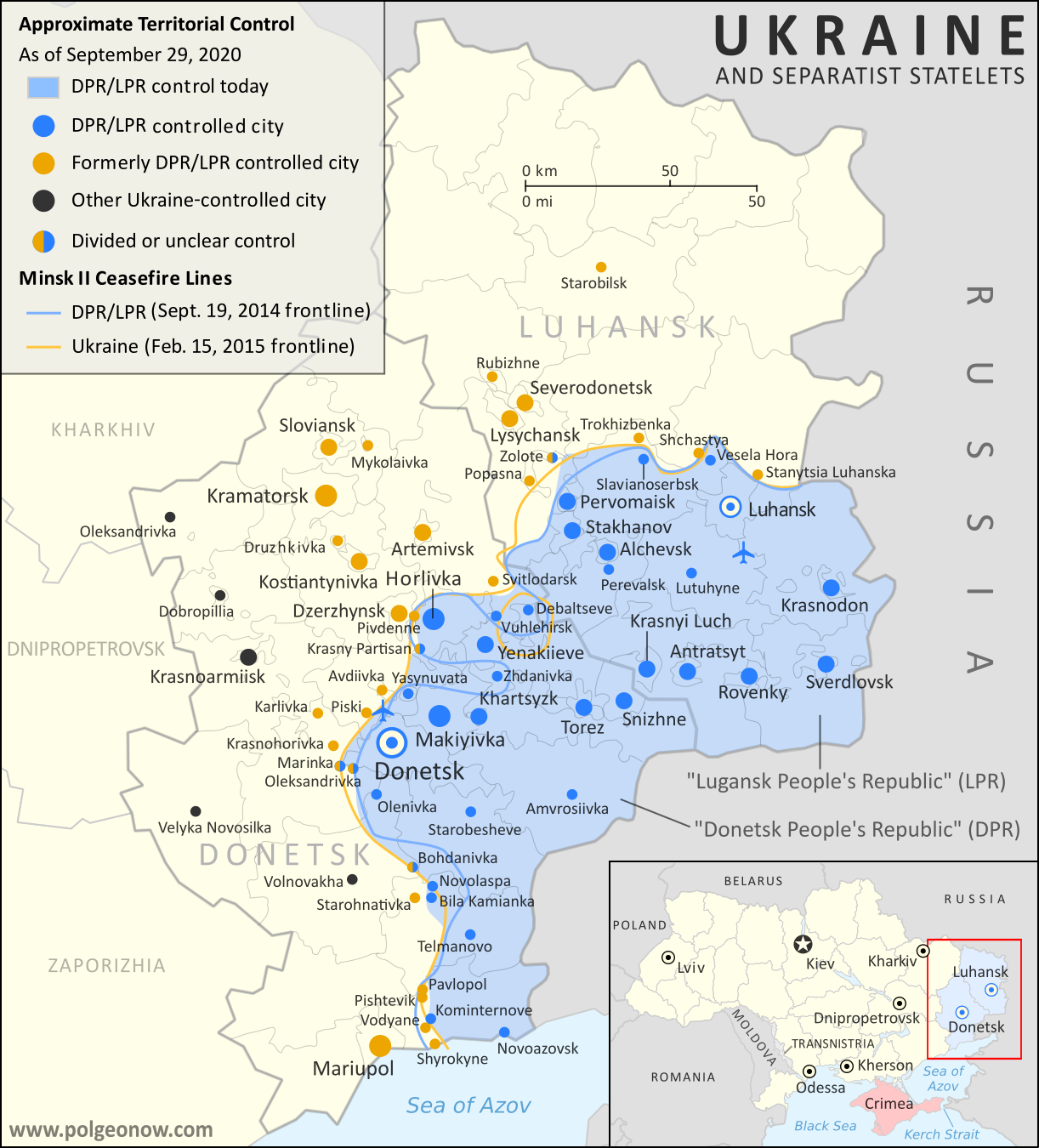
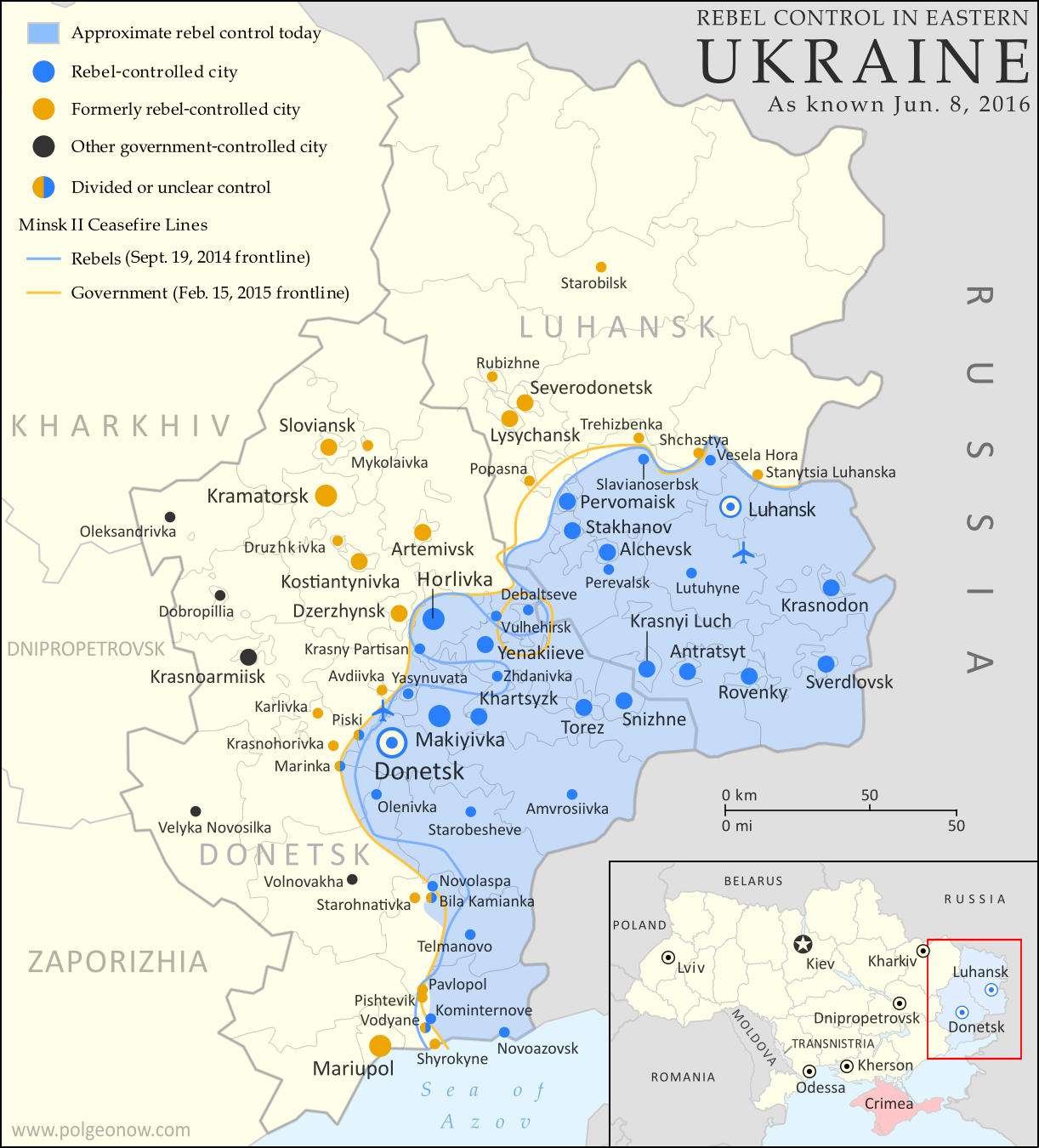
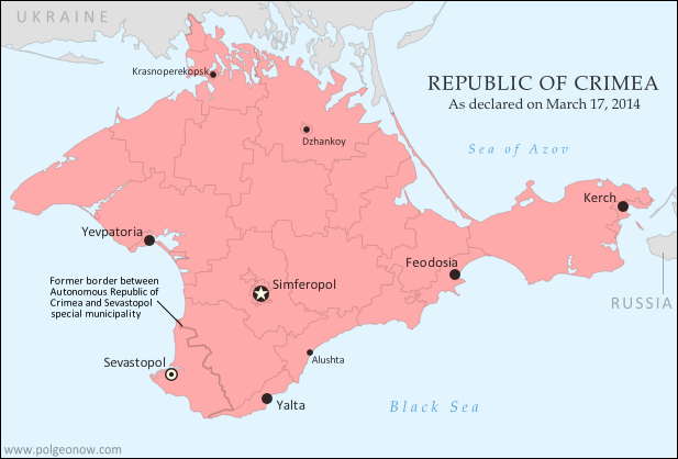
Months of US warnings that Russia was planning to invade Ukraine were proven right last Thursday, as Russian troops, tanks, ships, and aircraft flooded into the neighboring country. Russia had already taken over Ukraine's southern province of Crimea in 2014, and pro-Russia separatists claimed to have split off from eastern Ukraine after seizing much of Donetsk and Luhansk provinces. But Russia's full-scale invasion of Ukraine is a massive new escalation, unprecedented in Europe since World War II.

The above map shows control lines as of Sunday night - just before the first round of ceasefire talks - when Russian forces had captured significant chunks of rural Ukraine, but so far not gained control of any major cities (the situation a day later remains mostly unchanged). The map is based on reporting from various news media on the status of cities and towns, with lines of control in the countryside estimated with the help of other conflict-tracking websites and social media accounts.

Tuesday, September 29, 2020

Ukraine War Control Map & Report: September 2020

To see other maps in this series, plus a new map of Russian control in the 2022 invasion, view all Ukraine articles on PolGeoNow.
Map of territorial control and frontlines in the Donbass region of Donetsk and Luhansk, internationally recognized as part of eastern Ukraine but partly controlled by the breakaway Donetsk People's Republic and Lugansk People's Republic. Updated for September 2020, with Minsk ceasefire lines shown. Colorblind accessible.
Map by Evan Centanni and Djordje Djukic. Contact us for permission to use this map.

(Subscribers click here to view this article in the member area)

Timeline by Djordje Djukic, with additional reporting by Evan Centanni

Donbass Frontline Map

In the four years since PolGeoNow last updated our Ukraine control map, little has changed in terms of territorial boundaries in the region of eastern Europe known as the Donbass. Forces of the Russia-backed self-proclaimed Donetsk People's Republic (DPR) and Lugansk People's Republic (LPR) still hold a large chunk of what most of the world considers Ukraine, though their plans of formally uniting into a confederation of "Novorossiya" ("New Russia") have long gone by the wayside. But as attempts at resolving the conflict peacefully grind slowly forward, fighting has continued at a low level along the frontlines, and we have made some small changes to the map where the situation has either changed or been clarified since 2016.

Monday, March 20, 2017

Interactive Maps: Which Places Switched Time Zones in 2016?

This article is a spin-off from our popular yearly review of political geography events. For more on changes to countries and borders in 2016, check out our main 2016 year in review article

A time zone map of the world, showing all the world's standard time zones as of the beginning of 2017, with UTC offsets.
Free map of world time zones from Wikimedia Commons, up-to-date for the beginning of 2017. See the close-ups below for interactive, before-and-after illustrations of time zone changes during 2016.

Article and additional graphics work by Evan Centanni
 

Who Controls Time Zones?

The system of dividing the world into time zones is accepted all around the world, in principle. It's an organized way of letting clocks in each part of the world hit noon around the middle of daylight hours, even if it's midnight on the other side of the world. But surprisingly, there's actually no international organization that determines time zones. Except for in the open ocean, where time zones are standardized by a loose agreement between fleets and ship operators, the dividing lines are set independently by each country's government, or even by local governments below the national level.

Wednesday, June 8, 2016

Ukraine War Control Map & Report: June 2016

There are newer versions of this map available. To see them, view all Ukraine updates.

Subscribers click here to view this article in the ad-free members area. Not a member yet? Learn about PolGeoNow subscriptions!
Map of rebel territorial control in Ukraine's eastern provinces of Donetsk and Luhansk, claimed by the breakaway Donetsk People's Republic and Lugansk People's Republic. Updated for June 2016, with Minsk ceasefire lines shown.
Map by Evan Centanni (all rights reserved)
Timeline by Djordje Djukic, with additional reporting by Evan Centanni

Summary of Developments
PolGeoNow's previous Ukraine control map report was published in March of last year, just a month after a ceasefire was implemented under the Minsk II agreement, a hard-won deal between the Kiev government and representatives of the self-proclaimed Donetsk and Lugansk People's Republics (established by rebels with extensive support from the other side of the Russian border). Since then, the ceasefire has broadly held, which explains why the war in eastern Ukraine has largely dropped out of world newspaper front pages. However, fighting has continued off and on at a reduced level, and the ceasefire agreement is still on shaky ground. This map and timeline report describe what has happened over the past year, including some small changes to territorial control.

Thursday, February 11, 2016

Syrian Civil War Control Map: February 2016 (Subscription)

MEMBERS CLICK HERE TO PROCEED TO ARTICLE AND MAP

There are newer versions of this map available. To see them, view all Syria updates.

Research by Djordje Djukic. Map by onestopmap.com and Evan Centanni.

Subscribe for full access to all conflict map reports!

Download PDF:
Buy now
New discounted price!
Map of fighting and territorial control in Syria's Civil War (Free Syrian Army rebels, Kurdish YPG, Syrian Democratic Forces (SDF), Al-Nusra Front, Islamic State (ISIS/ISIL), and others), updated for February 2016. Now includes terrain and major roads (highways). Highlights recent locations of conflict and territorial control changes, such as Menagh airbase, northern Aleppo, Salma, Rabia, Nubl, Baghaliya, Tishrin Dam, and more. New: Improved map now includes terrain and major roads!

As a UN-brokered truce approached, tables were beginning to turn in Syria, with the government's Russian-backed offensive making major breakthroughs against rebel forces in Aleppo, Latakia, and elsewhere. 

Meanwhile, the so-called "Islamic State" (ISIS) continued to hold vast tracts of the country, while Kurdish-led forces gradually expanded their control in victories against ISIS and rebel fighters alike.

See all this and more on the newest update to PolGeoNow's concise, professional Syrian Civil War control map, which includes a timeline of changes since our previous Syria map report in mid-December.

This map and report are professional subscriber content, available to paid members or for separate purchase. Download PDF (US$14.99) New discounted price!

Want to see before you buy? Check out our most recent FREE SAMPLE Syria map!

Exclusive map report includes:
Map of fighting and territorial control in Syria's Civil War (Free Syrian Army rebels, Kurdish YPG, Syrian Democratic Forces (SDF), Al-Nusra Front, Islamic State (ISIS/ISIL), and others), updated for February 2016. Now includes terrain and major roads (highways). Highlights recent locations of conflict and territorial control changes, such as Menagh airbase, northern Aleppo, Salma, Rabia, Nubl, Baghaliya, Tishrin Dam, and more.
  • New in this edition: Terrain shading and major highways included on map for geographic context!
  • Up-to-date map of current territorial control in Syria, color-coded for the Assad government, rebel groups, "Islamic State" (ISIS/ISIL) extremists, and Kurdish YPG forces. 
  • Special symbols indicate towns dominated by rebels of Al Qaeda affiliate Jabhat al-Nusra (the Nusra Front) and by multi-ethnic anti-ISIS Syrian Democratic Forces (SDF).
  • Detailed indication of city-by-city control, highlighting key towns and other locations important to current events.
  • Locations of recent fighting and military operations, including Menagh airbase, Aleppo, Salma, Rabia, Nubl, Baghaliya, Tishrin Dam, and more.
  • Detailed timeline of important events and changes to territorial control since December 9, 2015, compiled by our Syria-Iraq expert, with links to sources.

MEMBERS CLICK HERE TO PROCEED TO ARTICLE AND MAP

Not a member yet? Click here to learn more about our professional subscription service!


Wednesday, December 9, 2015

Syrian Civil War Control Map: December 2015 (Subscription)

There are newer versions of this map available. To see them, view all Syria updates.

Map of fighting and territorial control in Syria's Civil War (Free Syrian Army rebels, Kurdish YPG, Syrian Democratic Forces (SDF), Al-Nusra Front, Islamic State (ISIS/ISIL), and others), updated for December 2015. Highlights recent locations of conflict and territorial control changes, such as Kweires airbase, Hader, Kafrah, Delha, Deir Hanna, Sheikh Meskin, Hawl, and more.
Subscribe for full access to all conflict map reports!

Download PDF:
Buy now
Research by Djordje Djukic, with additional reporting by Evan Centanni

The Syrian government's newly Russian-backed offensive against rebels and the so-called "Islamic State" (IS, formerly ISIS) is beginning to pick up momentum. Meanwhile, Western European countries are increasingly becoming involved in the war on IS as well, with a new Western-backed, multi-ethnic ground coalition making significant gains of its own against the group.

See all this and more on the newest update to PolGeoNow's concise, professional-quality Syrian Civil War control map, which includes a timeline of changes since our previous Syria map report near the end of October.

This map and report are professional subscriber content, available to paid members or for separate purchase. Download PDF (US$24.99)

Want to see before you buy? Check out our most recent FREE SAMPLE Syria map!

Exclusive map report includes:
  • Up-to-date map of current territorial control in Syria, color-coded for the Assad government, rebel groups, "Islamic State" (ISIS/ISIL) extremists, and Kurdish YPG forces. Special symbol indicates rebel-held towns dominated by Al Qaeda affiliate Jabhat al-Nusra (the Nusra Front).
  • New in this edition: Special symbol indicates towns held by multi-ethnic anti-ISIS Syrian Democratic Forces (SDF).
  • Detailed indication of city-by-city control, highlighting key towns and other locations important to current events.
  • Locations of recent fighting and military operations, including Kweires airbase, Hader, Kafrah, Delha, Deir Hanna, Sheikh Meskin, Hawl, and more.
  • Detailed timeline of important events and changes to territorial control since October 30, 2015, compiled by our Syria-Iraq expert, with links to sources.

MEMBERS CLICK HERE TO PROCEED TO ARTICLE AND MAP

Not a member yet? Click here to learn more about our professional subscription service!


Saturday, October 31, 2015

Syrian Civil War Control Map: October 2015 (Subscription)

There are newer versions of this map available. To see them, view all Syria updates.

Map of fighting and territorial control in Syria's Civil War (Free Syrian Army rebels, Kurdish YPG, Al-Nusra Front, Islamic State (ISIS/ISIL), and others), updated for late October 2015. Highlights recent locations of conflict and territorial control changes, such as Kweires airbase, Kafr Nabudah, Aleppo area, Hama province towns, and more.
Subscribe for full access to all conflict map reports!

Download PDF:
Buy now
Research by Djordje Djukic, with additional reporting by Evan Centanni

A month into Russia's military intervention in Syria, the Assad government and Iranian troops have made a number of small advances against both the rebels and the so-called "Islamic State" (formerly ISIS/ISIL).

See all this and more on the newest update to PolGeoNow's concise, professional-quality Syrian Civil War control map, which includes a timeline of changes since our previous Syria map report last month.

This map and report are professional subscriber content, available to paid members or for separate purchase. Download PDF (US$24.99)

Want to see before you buy? Check out our most recent FREE SAMPLE Syria map!

Exclusive map report includes:
  • Up-to-date map of current territorial control in Syria, color-coded for the Assad government, rebel groups, "Islamic State" (ISIS/ISIL) extremists, and Kurdish YPG forces. Special symbol indicates rebel-held towns dominated by Al Qaeda affiliate Jabhat al-Nusra (the Nusra Front).
  • Detailed indication of city-by-city control, highlighting key towns and other locations important to current events.
  • Locations of recent fighting and military operations, including Kweires airbase, Kafr Nabudah, the southern Aleppo countryside, northern Hama province, and more.
  • Detailed timeline of important events and changes to territorial control since September 14, 2015, compiled by our Syria-Iraq expert, with links to sources.

MEMBERS CLICK HERE TO PROCEED TO ARTICLE AND MAP

Not a member yet? Click here to learn more about our professional subscription service!


Thursday, May 14, 2015

Map: Another Country Joins the "Eurasian Union" (May 2015)

Map of the Eurasian Economic Union (EEU), also known as the Eurasian Union. Includes new member Kyrgyzstan, as well as prior members Russia, Belarus, Kazakhstan, and Armenia, and disputed territory Crimea
The Eurasian Economic Union's five current member countries, plus disputed Crimea, claimed to be part of Russia. Map by Evan Centanni, starting from this map by Keverich2. License: CC BY-SA
Premium members click here to view this article in the ad-free members area. Not a member yet? Subscribe now!

Tuesday, April 21, 2015

What is the "Eurasian Union"? (Map)

The Russia-led Eurasian Economic Union, sometimes simply called the "Eurasian Union", was officially launched at the beginning of this year. Read on for a brief introduction to this major new regional organization, which you can expect to hear a lot more about in the coming months and years!
Map of the Eurasian Economic Union (EEU), also known as the Eurasian Union. Includes new member Armenia, as well as prior members Russia, Belarus, and Kazakhstan, and disputed territories Crimea and Nagorno-Karabakh, as well as acceding member Kyrgyzstan.
The Eurasian Economic Union's four current member countries, plus disputed territories officially or unofficially included in the common market. Map by Evan Centanni, starting from this map by Keverich2. License: CC BY-SA
Premium members click here to view this article in the ad-free members area. Not a member yet? Subscribe now!

Article by Karina Barquet

Wednesday, March 18, 2015

Ukraine War Rebel Control Map: March 2015 (Subscription)

There are newer versions of this map available. To see them, view all Ukraine updates.

Detailed map of pro-Russian rebel control in Ukraine's eastern provinces of Donetsk and Luhansk, claimed by the breakaway Donetsk People's Republic and Lugansk People's Republic. Updated for March 2015, with February ceasefire lines and buffer zones shown. Includes detailed timeline of events since December.

Download PDF:
Buy now


(Subscribe via Paypal to access all premium content online)
Timeline by Djordje Djukic, with map and additional reporting by Evan Centanni

Fighting in Ukraine has come nearly to a halt with the implementation of February's ceasefire.  

This brand new, redesigned map is more accurate and detailed than maps in the news media, showing rebel control as it currently stands alongside the location of important ceasefire lines and buffer zones according to our own careful research.

Included in the report is a detailed accounting of events since our previous Ukraine update in December, compiled by our Ukraine specialist.

This map report is exclusive premium content, available to paid subscribers or for individual purchase.
Buy now (US$14.99)

Exclusive map report includes:
  • All new, updated map of Donetsk and Luhansk regions, showing actual lines of control
  • Map of February 15 ceasefire lines and buffer zones, depicted more accurately and precisely than in major news media sources
  • Improved depiction of regional cities and towns, showing past and current rebel control with larger dots for larger population sizes.
  • Timeline of events since December, plus summary of major trends

MEMBERS CLICK HERE TO PROCEED TO ARTICLE AND MAP

NOT A MEMBER YET? SUBSCRIBE NOW!


Monday, December 22, 2014

Ukraine War Rebel Control Map: December 2014 (Premium)

There are newer versions of this map available. To see them, view all Ukraine updates.

Detailed map of pro-Russian rebel control in Ukraine's eastern provinces of Donetsk and Luhansk, claimed by the breakaway Donetsk People's Republic and Lugansk People's Republic. Updated to December 21, 2014

Download PDF
Buy now


(Subscribe via Paypal to access all premium content online)
Research by Djordje Djukic, with additional reporting by Evan Centanni

Control lines have begun to solidify in Ukraine's civil war, with government forces on one side and the fighters of the self-proclaimed Donetsk People's Republic, Lugansk People's Republic, and Federation of Novorossiya on the other side. 

PolGeoNow presents our district-by-district map of control in eastern Ukraine, updated for December 2014, including a timeline of major events and changes to territorial control since our previous Ukraine map update in September.

This map report is exclusive premium content, available to paid subscribers or for individual purchase.
Buy now (US$9.99)

Premium map includes:
  • Detailed, updated map of Donetsk and Luhansk regions, showing both past and current rebel control
  • Indication of which districts and cities have had their administrations occupied by separatists
  • Timeline of changes to territorial control since September, and summary of major trends

MEMBERS CLICK HERE TO PROCEED TO ARTICLE AND MAP

NOT A MEMBER YET? SUBSCRIBE NOW!


Tuesday, October 14, 2014

Map: "Eurasian Union" Gets New Member

Map of the Eurasian Economic Union (EEU), also known as the Eurasian Union. Includes new member Armenia, as well as prior members Russia, Belarus, and Kazakhstan, and disputed territories Crimea and Nagorno-Karabakh.
The Eurasian Economic Union's four member countries, plus disputed territories that might be officially or unofficially included. Map by Evan Centanni, starting from this map by Keverich2. License: CC BY-SA
Premium members click here to view this article in the ad-free members area. Not a member yet? Subscribe now!

Tuesday, September 2, 2014

Ukraine War Rebel Control Map: September 2014 (Premium)

There are newer versions of this map available. To see them, view all Ukraine updates.

Detailed map of pro-Russian rebel control in Ukraine's eastern provinces of Donetsk and Luhansk, claimed by the breakaway Donetsk People's Republic and Lugansk People's Republic. Updated to September 1, 2014

Download PDF
buy


(Subscribe via Paypal to access all premium content online)
Russia is now being accused of directly invading eastern Ukraine, and opposition control in the region has seen major changes since our last Ukraine war map update.

This is detailed map and timeline of pro-Russian territorial control in eastern Ukraine's Donetsk and Luhansk regions, home to the claimed Donetsk People's Republic, Lugansk People's Republic, and Federation of Novorossiya. Updated to the start of September 2014.

This map report is exclusive premium content, available to paid subscribers or for individual purchase.
Buy now (US$9.99)

Premium map includes:
  • Detailed, updated map of Donetsk and Luhansk regions, showing both past and current rebel control
  • Indication of which districts and cities have had their administrations occupied by separatists
  • Timeline of changes to territorial control since July, and summary of major trends

MEMBERS CLICK HERE TO PROCEED TO ARTICLE AND MAP

NOT A MEMBER YET? SUBSCRIBE NOW!


Tuesday, July 22, 2014

War in Ukraine: Detailed Map of Rebel Control in Donetsk & Luhansk (Premium)

etailed map of rebel control in Ukraine's eastern provinces of Donetsk and Luhansk, claimed by the breakaway Donetsk People's Republic and Lugansk People's Republic. Updated to July 22, 2014

Download PDF
buy


(Subscribe via Paypal to view all premium content online)
All new, detailed map of rebel control in eastern Ukraine's Donetsk and Luhansk regions, home to the claimed Donetsk People's Republic, Lugansk People's Republic, and Federation of Novorossiya. 

Since our last Ukraine update, pro-Russian rebels have captured much more territory in Donetsk and Luhansk regions, but also lost some of their early strongholds. 

This map report is exclusive premium content, available to paid subscribers or for individual purchase.
Buy now (US$9.99)

Premium map includes:
  • All new, detailed map of Donetsk and Luhansk regions, showing both past and current rebel control
  • Indication of which districts and cities have had their administrations occupied by separatists
  • Important locations of rebel military control marked
  • Article with chronology of events since April, and discussion of the meaning of "control"

MEMBERS CLICK HERE TO PROCEED TO ARTICLE AND MAP

NOT A MEMBER YET? SUBSCRIBE NOW!


Wednesday, April 16, 2014

Ukraine Map #3: Separatist Control in the East (Premium)

Updated map of control in Ukraine, as of April 16, 2014. Spotlight on control by separatists in the country's east, including armed takeovers and the claimed Donetsk People's Republic.

Download PDF
buy


(Subscribe via Paypal)
Since our previous Ukraine update ten days ago, there has been a spectacular resurgence of aggressive separatist activity in eastern Ukraine, including not only protester occupations but also armed seizures reminiscent of those that began the Crimea crisis last month.

This is an up-to-date and detailed map of pro-Russian rebel and protester control in Ukraine, including the self-proclaimed "Donetsk People's Republic".

This map and article are exclusive premium content, available only to members or for individual purchase. Buy now (US$5.99).

Premium article includes:
  • Ukraine control map updated for the protester occupations and armed rebel takeovers in eastern Ukraine over the past two weeks
  • Shows both protester occupations and armed takeovers, as well as which regions have declared independence
  • Includes a quick briefing on recent events, with links to the sources of information
Members click here to proceed to article and map

Not a member yet? Subscribe Now!


Saturday, April 5, 2014

Update: Ukraine Control Overview Map (Premium)

Updated map of control in Ukraine, as of April 5, 2014. Includes final protester occupations, annexation of Crimea, and areas seized by Russian and Ukrainian militaries outside of Crimea.

Download PDF
buy


(Subscribe via Paypal)
This is a brief supplement to our Mar. 4 report, Ukraine Map: Occupations, Autonomy, & Invasion. See that report for a detailed overview of protester occupations and declarations of autonomy in the first two stages of the Ukraine crisis: the anti-Yanukovich Maidan movement and the eastern pro-Russian protests. 

The current article is an update on the current control situation in Ukraine from Mar. 4 to the present. This map and article are exclusive premium content, available only to members or for individual purchase. Buy now (US$5.99).

Premium article includes:
  • Simple updated map of the political situation in Ukraine since Mar. 4
  • Shows the last of the pro-Russian protester occupations, the annexation of Crimea, and seizures by the Ukrainian and Russian militaries outside of Crimea proper
  • Report on the course of events since the last report, explaining each detail shown on the map
  • In-line links to sources of information

Members click here to proceed to article and map

Not a member yet? Subscribe Now!


Thursday, March 27, 2014

Crimea Joins Russia, Gives Up Independence, Becomes Disputed Territory

Premium members click here to view this article in the ad-free members area. Not a member yet? Subscribe now!

Map of the claimed Republic of Crimea, which briefly declared independence from Ukraine on Mar. 17 before being annexed by Russia
The claimed Republic of Crimea which has now joined Russia (click to see full-sized map). By Evan Centanni, based on this blank map.
By Evan Centanni

Russia Annexes Crimea
The Crimean peninsula, which declared independence from Ukraine ten days ago as the Republic of Crimea, has now been absorbed into Russia. This was part of the plan all along - the claimed Republic of Crimea had requested to join Russia at the same time that it declared independence.

Related: Complete Map of Locations Seized by Russia in Crimea (Premium)

Wednesday, March 26, 2014

Premium Map Report: Russian Control of Crimea

Map of Russian seizures and military actions in the Crimea region which it recently annexed from Ukraine.

Download PDF
buy


(Subscribe via Paypal)
After a month of low-level conflict, Russian military control of Crimea appears to be nearly complete. Here's a complete map - to the best of our knowledge - of all locations of Russian seizures and other military actions inside and outside of the Crimea region. This map and article are exclusive premium content, available only to members and for individual purchase. Buy now (US$4.99).

Premium article includes:
  • Exclusive map of Russian seizure and attack locations inside and outside of Crimea
  • Guide to all locations on the map, with brief summary of what has happened at each
  • In-line links to sources of information

Members click here to proceed to article and map

Not a member yet? Subscribe Now!


Tuesday, March 18, 2014

Crimea Declares Independence: Is It Really a Country?

On Monday, two regional governments on the Crimean Peninsula controversially declared their independence from Ukraine as the new Republic of Crimea. While the declaration has been rejected by most of the world community, and Crimea hopes to swiftly unite with Russia, for now it might be considered a de facto sovereign state. Read on for details.

Map of the newly declared independent Republic of Crimea, seceding from Ukraine to join Russia (colorblind accessible).
The Republic of Crimea. Map by Evan Centanni, based on this blank map.
Premium members click here to view this article in the ad-free members area. Not a member yet? Subscribe now!

By Evan Centanni

Declaration of Independence
Following Ukraine's revolution, the explosion of pro-Russian protests in the east, and the subsequent occupation of the Crimean peninsula by Russian forces (see our premium report, Ukraine Map: Occupations, Autonomy, & Invasion), a new independent country has been declared on the coast of the Black Sea.

Saturday, March 8, 2014

How Sharply Divided is Ukraine, Really? Honest Maps of Language and Elections

There's no question that Ukraine's current crisis arose from major political divisions in the country, and it's true that language is an issue. But some online news websites have sensationalized and exaggerated these divisions through misleading maps. PolGeoNow offers a pair of maps that better communicate the blurriness of the supposed lines between western and eastern Ukraine. 

(For a map of current events from January up to this week, including protester control, government occupations, and the Russian invasion, purchase our premium map of the Ukraine crisis or become a member.)

Map of the results of Ukraine's February 2010 presidential runoff election between Yulia Tymoshenko and Viktor Yanukovich
A more honest map of Ukraine's 2010 presidential election. By Evan Centanni.
Premium members click here to view this article in the ad-free members area. Not a member yet? Subscribe now!

Article by Evan Centanni 

Misleading Ukraine Maps
In January, the Washington Post's Max Fisher wrote a popular map-illustrated blog post about the political and linguistic divisions fueling Ukraine's crisis, then at the height of its pro-Europe protest phase. Later, CNN followed the Post's lead and published a similar set of maps. However, the maps in both articles are designed in a way that makes the divisions look much sharper and more black-and-white than they really are. There's not, as Fisher preposterously claims, "an actual, physical line" splitting Ukraine in half. Instead, there's a gradual shading of mixed populations whose ethnic identities and voting history don't always correlate to the country's current political divisions.