 |
Map by Evan Centanni and Djordje Djukic. Contact us for permission to use this map.
|
(Subscribers click here to view this article in the member area)
Timeline by Djordje Djukic

Updates on the world's countries and borders
|
Map by Evan Centanni and Djordje Djukic. Contact us for permission to use this map.
|
 |
Map by Evan Centanni and Djordje Djukic. Contact us for permission to use this map.
|
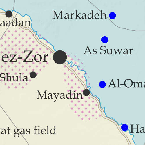 Despite no changes to Syria's lines of control since 2020, the so-called "Islamic State" (ISIS/ISIL) has continued a bloody insurgency in the central desert, which has increasingly occupied the Assad government and its Russian and Iranian allies. Meanwhile, fighting between Kurdish- and Turkish-led forces has carried on sporadically, and a sort of rebel resurgence in the southwest has come and gone.
This map and report are premium content, available to paid subscribers of the PolGeoNow Conflict Mapping Service.
Want to see before you subscribe? Check out our most recent FREE SAMPLE Mozambique map!
Exclusive map report includes:

(There are newer versions of this map available. To see them, view all Ethiopia articles on PolGeoNow.)
As a followup to the three Tigray war maps we've published as guest features from Daniel of Passport Party, PolGeoNow is pleased to present our new in-house map of control in Ethiopia's ongoing civil war. The new map shows Tigray rebel control both today and at its greatest extent last November, while also highlighting a second insurgency by allied rebel group the Oromo Liberation Army.
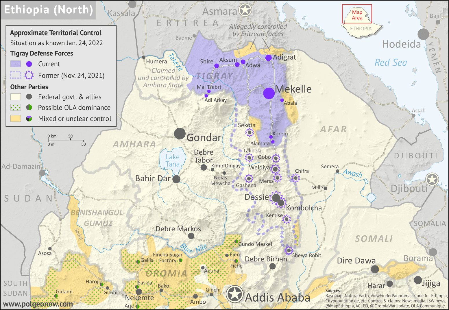 |
Map by Evan Centanni and Djordje Djukic. Terrain data sourced from ViewFinderPanoramas.
Contact us for permission to use this map. |
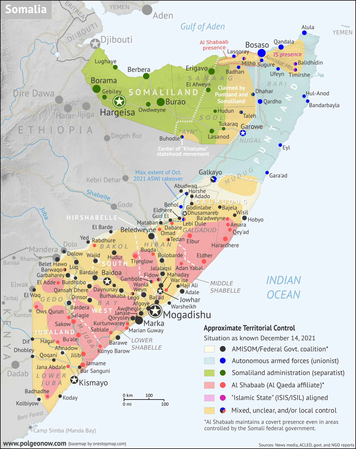 |
Base map by Koen Adams of onestopmap.com, with territorial control by Evan Centanni and Djordje Djukic.
Contact us for permission to use this map. |
In the nearly 10 months since PolGeoNow's previous Somalia control map report, the country's news cycle has been dominated by a series of interconnected political crises that have led the federal government's military to the brink of civil war. All the while, the fight against Al Qaeda affiliate Al Shabaab, which operates a parallel government across much of Somalia's countryside, has continued to see a mix of victories and defeats for each side. And while the standoff between the federal army and Jubaland state forces has ended, new regional conflicts have erupted in Hirshabelle and Galmudug states, including a major resurgence of the controversial ASWJ militia.
Read on for concise summaries of the past 10 months' political crises and military trends, followed by a detailed timeline of events since February. Sources for our reporting, and for changes to the map since last time, are covered in the detailed timeline and the additional source notes at the bottom of the page.


 |
Mozambique's insurgents have been pushed out of their most prized territories, but are still fighting on in other areas. |
PolGeoNow's coverage of the insurgency in Mozambique's Cabo Delgado province has, as usual, been largely focused on who controls what territory in the conflict - and though insurgents have recently lost their most prominent territorial holdings, they're still a force to be reckoned with.
But there's one big question that still hangs over the story, relevant both to how the outside world should view the insurgency and to what the rebels are even called:
A year after they made international headlines by capturing and holding onto the major town of Mocímboa da Praia, the short answer is still "probably sort of".
The so-called "Islamic State" (IS; formerly ISIS or ISIL), though it started in Iraq and Syria and still is based there, has also established branches and franchises - with varying degrees of connection to IS headquarters - in far-flung countries around Africa and Asia. So the more specific question is: Are the Cabo Delgado insurgents genuinely connected to IS, and if so, how connected?
 |
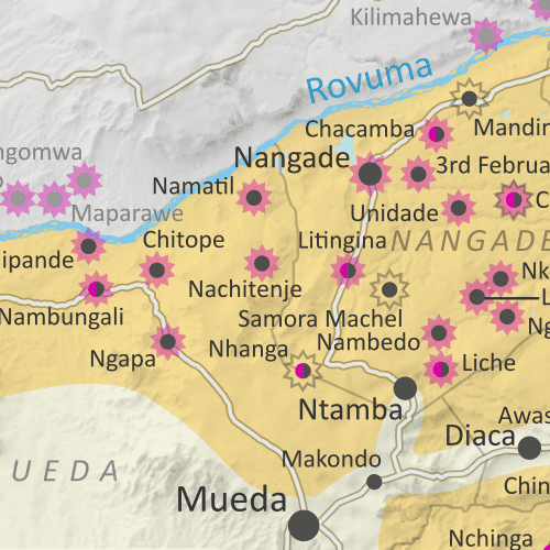
| At the height of their control earlier this year, secretive insurgents dominated a small but important corner of Mozambique. (Map from our July 2021 Cabo Delgado update.) |
In our August 2020 Mozambique conflict map article, we discussed confusion over the name of the insurgent group operating in Cabo Delgado province. Now, a year later, we've decided it's time to briefly revisit that question.
Though the fighters have now been pushed out of their most prized territories, they're still present in the region in large numbers, so questions about their identity remain highly relevant.
At this point there's no longer
much question that the group's most commonly-used name in Cabo Delgado -
by both its opponents and the insurgents themselves
- is "Al-Shabab". This unofficial name, which means "the youth" in
Arabic (the international language of the Islamic religion, but not of
everyday communication in Mozambique), appears to be a reference to
the Al Shabaab insurgent group in Somalia. Though the word is usually spelled "Shabaab" in the Somali context, and international commentary often uses this spelling for the Cabo Delgado insurgents too, local spelling conventions in Mozambique tend to prefer "Shabab" without the double A.

This map and report are premium content, available to paid subscribers of the PolGeoNow Conflict Mapping Service.
(Note: Though Rwanda's defense department has been seen using our Cabo Delgado map
in a press briefing, PolGeoNow has no known contact or business
relationship with the Rwandan government or military, and the map was
used without our prior knowledge. As always, PolGeoNow does not endorse
any actor, organization, or policy in any armed conflict or political
dispute.)
Want to see before you subscribe? Check out our most recent FREE SAMPLE Mozambique map!
Exclusive map report includes:
Update: PolGeoNow now has an in-house map showing territorial control in northern Ethiopia. To find the latest version, view all Ethiopia reports.
In a dramatic reversal, Tigray rebels are now on the offensive after recapturing their state's capital in northern Ethiopia. To illustrate the current situation, PolGeoNow is again honored to feature a territorial control map created by our colleague Daniel from Passport Party. Also included is a timeline of events since the previous update in February.
 |
| Map of control in Tigray and surrounding areas in early August 2021, by Daniel of Passport Party (used with permission). |

This map and report are premium content, available to paid subscribers of the PolGeoNow Conflict Mapping Service.
Want to see before you subscribe? Check out our most recent FREE SAMPLE Mozambique map!
Exclusive map report includes:
There are newer versions of this map available. To see them, view all Central African Republic articles on PolGeoNow.
We've revived and relaunched our coverage of territorial control in the Central African Republic, one of PolGeoNow's original areas of reporting from back in 2013. The timeline in this article covers the entire period from then up to now, and going forward, our newly-redesigned map will be updated as needed. To ensure your access to future updates, sign up for our conflict mapping service.
 |
| Map by Evan Centanni and Djordje Djukic. Terrain data sourced from ViewFinderPanoramas. Contact us for permission to use this map. |
(Subscribers click here to view this article in the member area)
Timeline by Djordje Djukic and Evan Centanni
This is the 2021 edition of our Israel/Palestine control map, first published in July 2020. A newer version is now available.
 |
Click to enlarge. Map by Evan Centanni, incorporating base map by Koen Adams of onestopmap.com and data from B'Tselem's interactive mapping project. (Contact us for permission to use this map.)
|
The Israeli government's much-hyped plan to absorb parts of the Palestine-claimed West Bank into Israel in 2020 didn't happen (at least not yet). But in May 2021, the region was once again making headlines amid a new wave of fighting. So who actually controlled what parts of Palestine and Israel's claimed territories at the time? This revised version of PolGeoNow's Israel/Palestine control map lays out the details of government jurisdictions on the ground.
There were no changes to the lines of control between 2020 and this 2021 edition, but this edition of the map did feature several modifications for improved clarity and more precise depictions of the situation. If you see something you don't understand on the map, check out the latest edition of our concise outline explaining who's who and introducing each of the disputed areas.
Note that this is a map of who actually controls what, not of who claims which areas. And it's definitely not supposed to imply that any particular party should or shouldn't control any particular area. As always, PolGeoNow takes no side in these disputes, and we have done our best to report only the facts.
Newer Map and Explainer Article: Who Controls What in the Israel-Palestine conflict?

 Libya's civil war entered a stalemate after the eastern government's failure to capture Tripoli from the western government last year - and now it's been tentatively declared over after a peace deal and formation of a unity government.
But for the time being, the lines of control between former opposing military forces remain in place, and we've made some adjustments to the map based on newly-available information.
See all this and more on the latest update to PolGeoNow's concise, professional Libya control map, which comes with a timeline of changes since our previous Libya control map report of June 21, 2020.
This map and report are premium content available to paid subscribers of the PolGeoNow Conflict Mapping Service.
Want to see before you subscribe? Check out our most recent FREE SAMPLE Libya map!
Exclusive report includes:
There are newer editions of this map available. To see them, view all Mozambique articles on PolGeoNow.
It's finally here: the close-up, super-detailed version of our Mozambique insurgency control map! This edition depicts the situation near the beginning of this month, when the government was fighting for control of Palma. A new close-up version of our August 2020 map is also now available, and future updates are expected more frequently from now on. To see the full list of reports, you can always view all Mozambique articles on PolGeoNow.
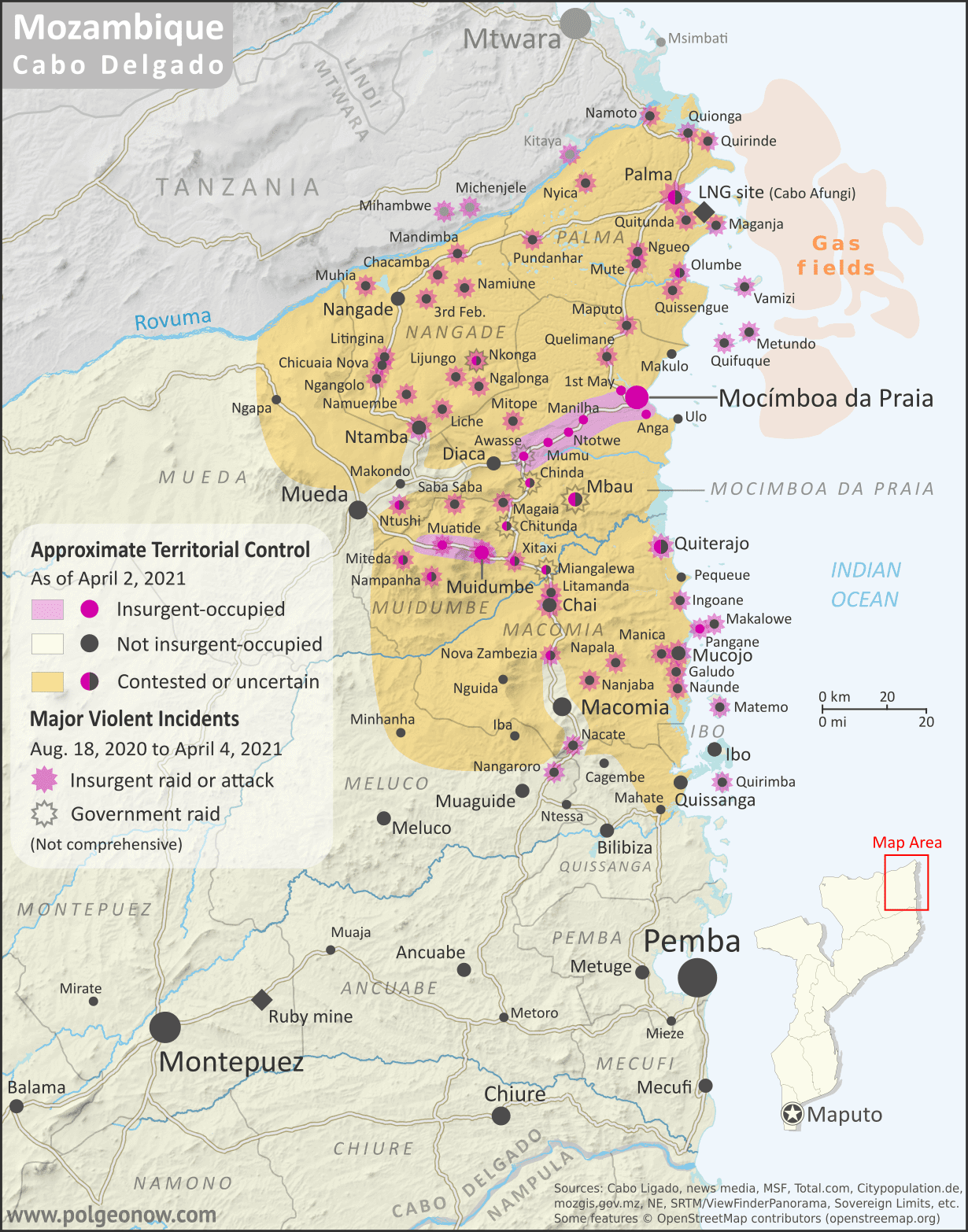 |
Map by Evan Centanni and Djordje Djukic. Some elements © OpenStreetMap contributors. Terrain data sourced from ViewFinderPanoramas. Contact us for permission to use this map.
|
In the eight months since our first Mozambique conflict timeline was published, insurgents in Cabo Delgado province have gradually increased their control, continuing to raid villages and towns in multiple districts, culminating most recently in their temporary takeover of most of Palma, a major town close to under-construction natural gas facilities operated by French company Total. The rebel group - locally known as "Al Shabaab" but thought to formally label itself Ahlu Sunnah Wa-Jamâ (ASWJ) - is increasingly believed to be cooperating, if only loosely, with the so-called "Islamic State" (IS; ISIS/ISIL).
Now, for the first time, PolGeoNow presents our close-up map of the Cabo
Delgado conflict, rigorously researched and edited to provide the most
detailed, informative, and reliable map of insurgent control and attacks
available anywhere.

This map and report are premium content, available to paid subscribers of the PolGeoNow Conflict Mapping Service.
Want to see before you subscribe? Check out our most recent FREE SAMPLE Mozambique map!
Exclusive map report includes: