 |
| Map by Evan Centanni, from blank map by Eric Gaba. License: CC BY-SA |
Updates on the world's countries and borders
Showing posts with label intergovernmental organizations. Show all posts
Showing posts with label intergovernmental organizations. Show all posts
Friday, June 28, 2019
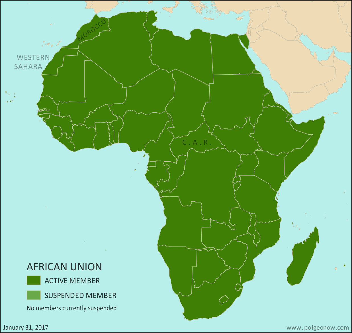
African Union Map Update: Sudan Suspended
Wednesday, March 7, 2018
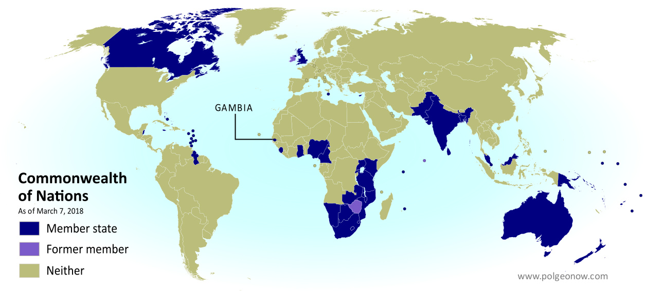
Gambia Rejoins the Commonwealth (Map)
 |
| Map by Evan Centanni, modified from public domain graphic. Visit our Commonwealth of Nations page to check for newer versions, or contact us for permission to use this map. |
Commonwealth Readmits Gambia as Member
Last month the Republic of the Gambia was accepted back into the Commonwealth of Nations, a club of countries that were formerly part of the British Empire. The tiny West African country left the organization in 2013 under pressure from other members to improve its democracy and human rights record.What Are the Commonwealth Countries? Map of the Commonwealth of Nations
This map and explainer will be updated whenever there's a change in Commonwealth membership, including suspensions and reinstatements. You can find articles on each change by scrolling to the bottom of this page, or by viewing all Commonwealth articles on PolGeoNow.
(Subscribers click here to view this article in the members area.)
 |
| Map by Evan Centanni, modified from public domain graphic. Contact us for permission to use this map. |
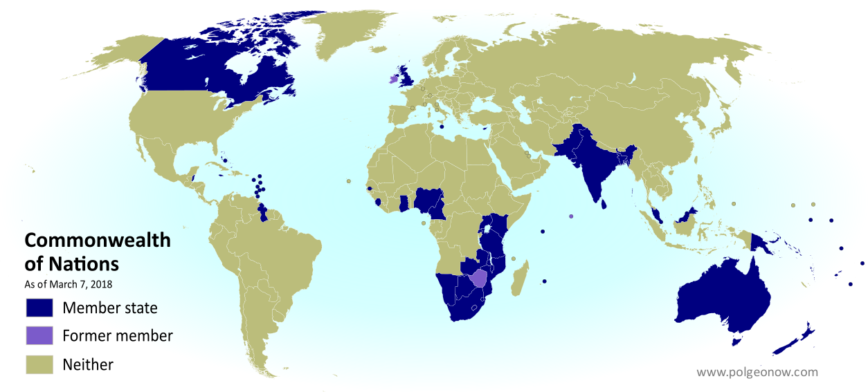
What is the Commonwealth of Nations?
The Commonwealth of Nations - formerly the "British Commonwealth", but now usually just called "the Commonwealth" - is a loose association of countries that grew out of the British Empire as its colonies transitioned into independent countries during the 20th Century. It more or less took its modern form in 1949, but its history goes back at least to 1926, when the most Westernized colonies of the British Empire were transitioning towards independence. It's mostly a casual forum for cooperation between countries that used to be British colonies or dependencies (though some other countries have joined), and it has a charter promoting values like world peace, democracy, and human rights.Tuesday, August 1, 2017
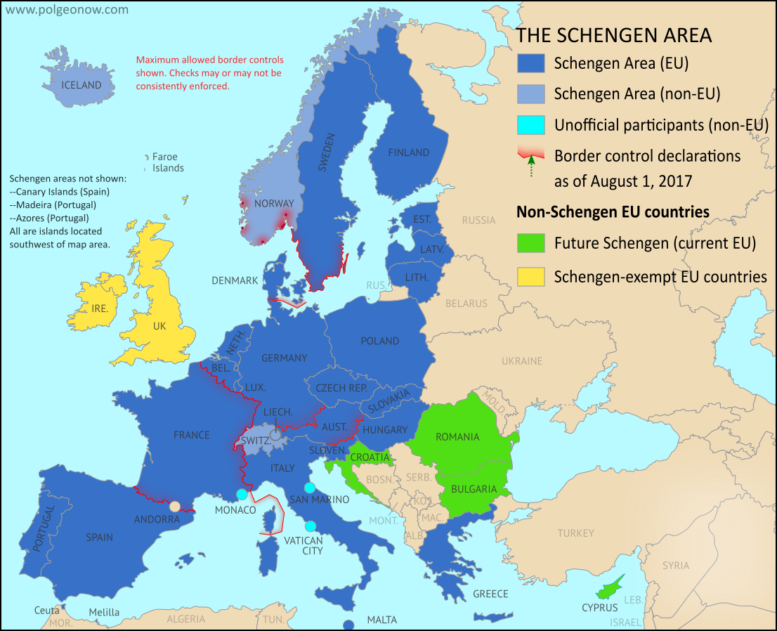
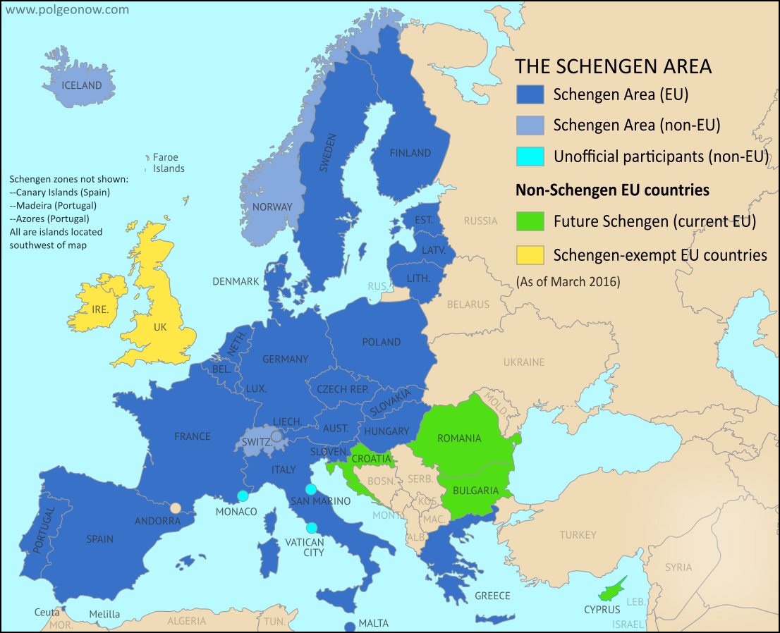
Map: Which Schengen Borders are Closed to Passport-Free Travel in August 2017?
There are newer versions of this map available. To see them, view all Schengen Area articles.
Last year, we explained Europe's Schengen free travel area in plain English, then published maps of which European countries had temporarily reintroduced border controls as of March 2016, August 2016, and February 2017. Here's an update and summary for August of 2017.
Article by Evan Centanni
Last year, we explained Europe's Schengen free travel area in plain English, then published maps of which European countries had temporarily reintroduced border controls as of March 2016, August 2016, and February 2017. Here's an update and summary for August of 2017.
 |
| Map by Evan Centanni, from blank map by Ssolbergj. License: CC BY-SA |
Current Border Controls Between Schengen Countries
As anyone who's visited Europe in recent decades knows, much of the continent is linked together as part of the "Schengen Area", a collection of countries that don't make travelers show any ID to cross back and forth across their borders (though this system is overseen by the European Union, the Schengen Area and the EU aren't the same thing). But the system does allow countries to temporarily reintroduce border controls under certain circumstances.Friday, June 23, 2017
Why Brexit Matters: 5 Things That Might Change When Britain Leaves the EU
By Bryn Jansson
UK voters’ surprise choice to leave the EU happened exactly a year ago, on June 23, 2016 - but it didn’t automatically trigger the two-year countdown clock on exit negotiations necessary for departure under Article 50 of the EU’s Lisbon Treaty.
 |
| Map of current and future EU member countries |
Brexit Process Finally Begins
The United Kingdom (UK) and the European Union (EU) began formal divorce negotiations in Brussels last Monday, June 19, starting a 21-month sprint to the March 2019 Brexit deadline. ("Brexit" is short for "British Exit" from the EU, since "Britain" is another name for the UK.)UK voters’ surprise choice to leave the EU happened exactly a year ago, on June 23, 2016 - but it didn’t automatically trigger the two-year countdown clock on exit negotiations necessary for departure under Article 50 of the EU’s Lisbon Treaty.
Saturday, May 6, 2017
The Maldives' Withdrawal from the Commonwealth
 |
| Map by Evan Centanni, modified from public domain blank world map |
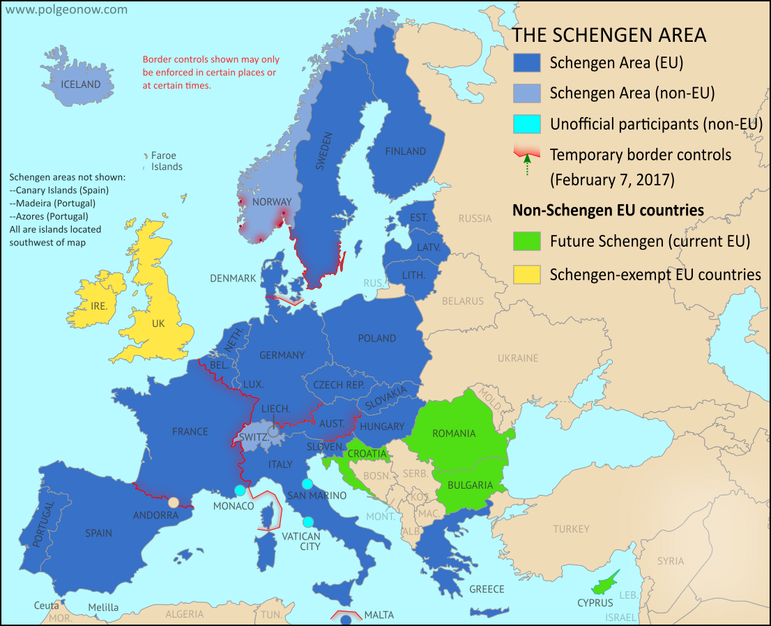
Tuesday, February 7, 2017
Schengen Border Controls in February 2017: Map of Free Travel Restrictions
There are newer versions of this map available. To see them, view all Schengen Area articles.
Last year, we explained Europe's Schengen free travel area in plain English, then published maps of which European countries had temporarily reintroduced border controls as of March 2016 and August 2016. We now present an updated map and summary of the situation.
(Subscribers click here to view this article in the members area.)
Article by Evan Centanni
Last year, we explained Europe's Schengen free travel area in plain English, then published maps of which European countries had temporarily reintroduced border controls as of March 2016 and August 2016. We now present an updated map and summary of the situation.
 |
| Map by Evan Centanni, from blank map by Ssolbergj. License: CC BY-SA |
Article by Evan Centanni
Changes to Schengen Border Controls Since 2016
As anyone who's visited Europe in recent decades knows, much of the continent is linked together as part of the "Schengen Area", a collection of countries that don't make travelers show any ID to cross back and forth across their borders (though this system is overseen by the European Union, the Schengen Area and the EU are not the same thing). But the system does allow countries to temporarily reintroduce border controls under certain circumstances.Thursday, February 2, 2017
Morocco Joins African Union; CAR Un-suspended (Map)
 |
| Map by Evan Centanni, from this blank map by Eric Gaba. License: CC BY-SA |
Article by Evan Centanni
Morocco Rejoins AU after Long Absence
The North African country of Morocco became the 55th member of the African Union (AU) this week, after member countries voted to let it back into the organization after 33 years on its own. Morocco withdrew from the Organisation for African Unity (OAU), an earlier version of the AU, in 1984. The AU now includes every independent country in Africa, not counting the unrecognized breakaway state of Somaliland. The last country to join was South Sudan, which became a member three weeks after declaring independence in July 2011.Wednesday, August 17, 2016
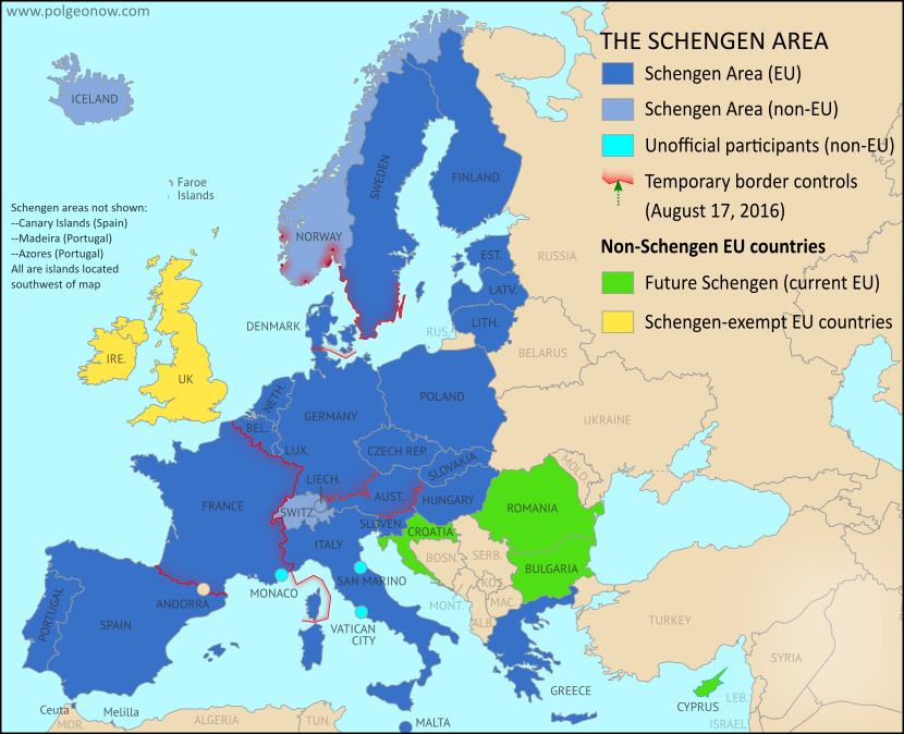
Map of Border Controls Inside Europe's Schengen Area: August 2016
There are newer versions of this map available. To see them, view all Schengen Area articles.
Last March, we explained Europe's Schengen free travel area in plain English, then published a map of which European countries had temporarily reintroduced border controls. We now present an updated and improved version of the border control map, reflecting several changes from the past five months.
(Subscribers click here to view this article in the members area.)
Article by Evan Centanni
With last year's spike in numbers of refugees and other immigrants arriving in Europe, many Schengen countries have rushed to control the flow of people by using these special temporary border controls. When we published our previous map of temporary Schengen border controls back in March, there were seven countries policing their borders with fellow Schengen members. Today there are only six, and there have been major changes to which borders are controlled:
Last March, we explained Europe's Schengen free travel area in plain English, then published a map of which European countries had temporarily reintroduced border controls. We now present an updated and improved version of the border control map, reflecting several changes from the past five months.
 |
| Map by Evan Centanni, from blank map by Ssolbergj. License: CC BY-SA |
Article by Evan Centanni
Changes to Schengen Border Controls Since March
As anyone who's visited Europe in recent decades knows, much of the continent is linked together as part of the "Schengen Area", a collection of countries that don't make travelers show any ID to cross back and forth across their borders (though this system is overseen by the European Union, the Schengen Area and the EU are not the same thing). But the system does allow countries to temporarily reintroduce border controls under certain circumstances.With last year's spike in numbers of refugees and other immigrants arriving in Europe, many Schengen countries have rushed to control the flow of people by using these special temporary border controls. When we published our previous map of temporary Schengen border controls back in March, there were seven countries policing their borders with fellow Schengen members. Today there are only six, and there have been major changes to which borders are controlled:
Thursday, July 28, 2016
Map: Liberia and Afghanistan Join WTO
(Subscribers click here to view this article in the members area.)
 |
| Map by Evan Centanni, from public domain blank map. |
Thursday, June 30, 2016
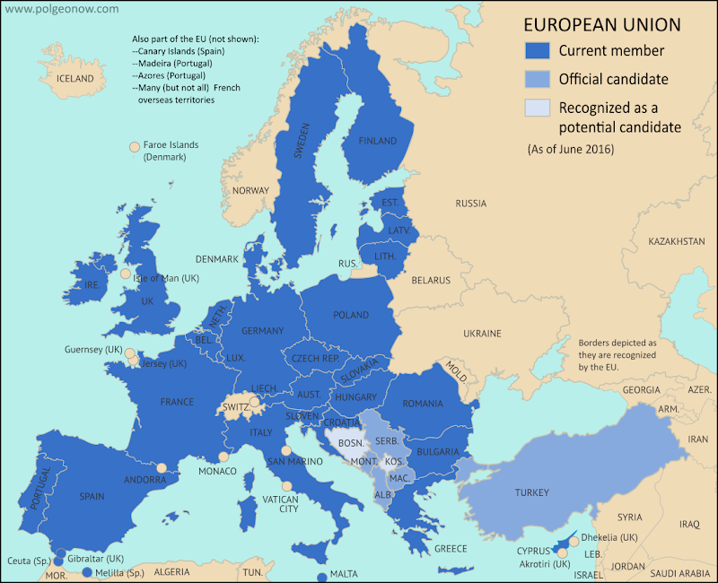
Map of European Union Member Countries Before Brexit (2014-2020)
There are newer editions of this map available. To see the most recent, visit our European Union explainer article.
This is an archived version of our map of European Union (EU) member and candidate countries, from before the UK's departure (known as "Brexit"). It's accurate for the period from June 2014, when Albania was recognized as an EU candidate country, to January 31, 2020, when the United Kingdom (UK) officially left the organization. The most recent country to join as a full member was Croatia in 2013.
For the current edition of this map, check out our updated feature article: Which Countries are in the European Union, Which Aren't, and Which Want to Join?
 |
| The UK is still part of the EU for now, since the vote to leave hasn't been implemented yet. Map by Evan Centanni, from blank map by Ssolbergj. License: CC BY-SA |
EU Member Countries Pre-Brexit
This is an archived version of our map of European Union (EU) member and candidate countries, from before the UK's departure (known as "Brexit"). It's accurate for the period from June 2014, when Albania was recognized as an EU candidate country, to January 31, 2020, when the United Kingdom (UK) officially left the organization. The most recent country to join as a full member was Croatia in 2013.
For the current edition of this map, check out our updated feature article: Which Countries are in the European Union, Which Aren't, and Which Want to Join?
Friday, June 24, 2016
UK Votes to Quit EU: Map of How Britain Voted in the Brexit Referendum
By Evan Centanni
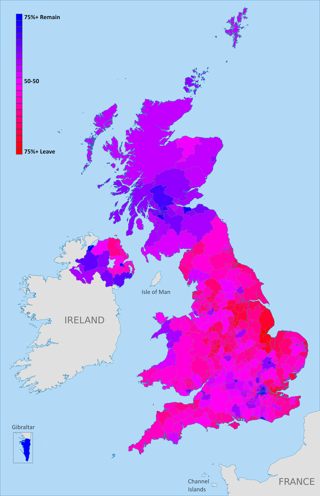 |
| Map of election results in the UK's "Brexit" referendum. Modified by Evan Centanni from Wikimedia map by Mirrorme22, Nilfanion, TUBS, and Sting (CC BY-SA). |
Brexit by Constituency
The results are in for yesterday's referendum on UK membership in the European Union, and the winner is "Leave". Brits voted by a margin of 52% to 48% in favor of exiting the European Union, making a "Brexit" (British exit from the EU) more or less guaranteed in the coming years. Britain will become the first member country ever to leave the EU, and the British overseas territory of Gibraltar is expected to get pulled out with it.Learn More: Brexit: 9 Geography Facts You Should Know About the Referendum and Britain's EU Membership
Who Voted to Stay
Voter tendencies varied a lot from place to place. Support for the "Remain" side was strong across Scotland, culturally Irish parts of Northern Ireland, the London area, and a handful of other cities in England (led by Cambridge, Oxford, and Brighton).By far the greatest show of support for Remain was a win by 96% in Gibraltar - which isn't even in the UK proper, but got to vote because of its unique status as a British external territory that's in the EU.
Thursday, June 23, 2016
Brexit: 9 Geography Facts You Should Know About the Referendum and Britain's EU Membership
(Subscribers click here to view this article in the members area.)
By Evan Centanni
Today the UK is voting on whether to leave the European Union. If you've been paying attention to the news, you've probably heard about the intense debate over whether Brits should vote "Leave" or "Remain". But if you're like me and mainly in this for the geography trivia, here are some fun facts you might not know about the so-called "Brexit":
By Evan Centanni
|
| The European Union. Click for full map and list of members. |
Tuesday, June 21, 2016
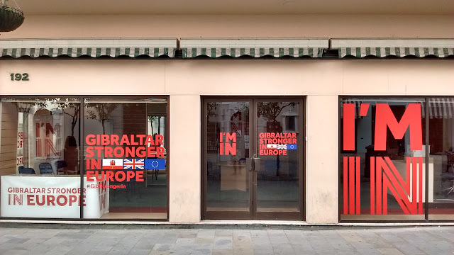
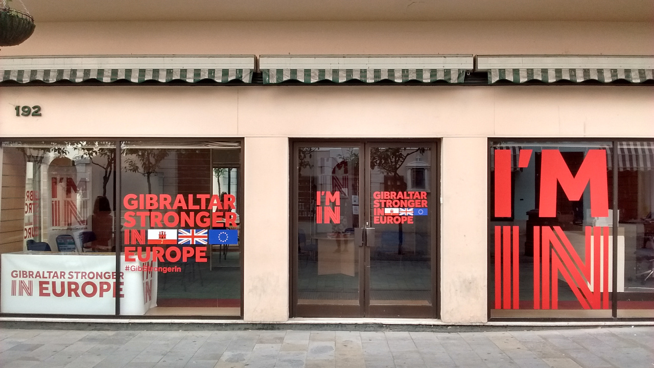
On the Ground: Gibraltar and the "Brexit" Referendum
This is the first installment of PolGeoNow's On the Ground, a new series of exclusive photo essays on what political geography looks like in the real world. Whether it's borders, nationalism, or other geopolitical phenomena, we'll bring the on-the-ground situations to your screen in vivid detail.
Update 2016-06-24: Gibraltar on Thursday voted in favor of the UK staying in the European Union, by an incredible margin of 96% to 4%. However, the UK as a whole voted to leave the EU, meaning that Gibraltar can expect to get pulled out with it, against the wishes of the Gibraltarians.
 Subscribers click here to view this article in the ad-free members area. Not a member yet? Learn about PolGeoNow subscriptions!
Gibraltar prepares to vote on whether UK should leave European Union
Last month, PolGeoNow's Evan Centanni and Meihsing Kuo visited the small British territory of Gibraltar (pronounced "jih-BRALL-ter"), one month ahead of the UK's referendum on whether to leave or remain in the European Union (EU).
Gibraltar, a tiny peninsula connected to Spain - and claimed by the Spanish government - is the only British overseas territory that's part of the EU. It's also the only external territory whose residents are eligible to vote in the so-called "Brexit" referendum without living in the UK proper. ("Brexit" is an abbreviation for "British exit" from the EU.)
Update 2016-06-24: Gibraltar on Thursday voted in favor of the UK staying in the European Union, by an incredible margin of 96% to 4%. However, the UK as a whole voted to leave the EU, meaning that Gibraltar can expect to get pulled out with it, against the wishes of the Gibraltarians.
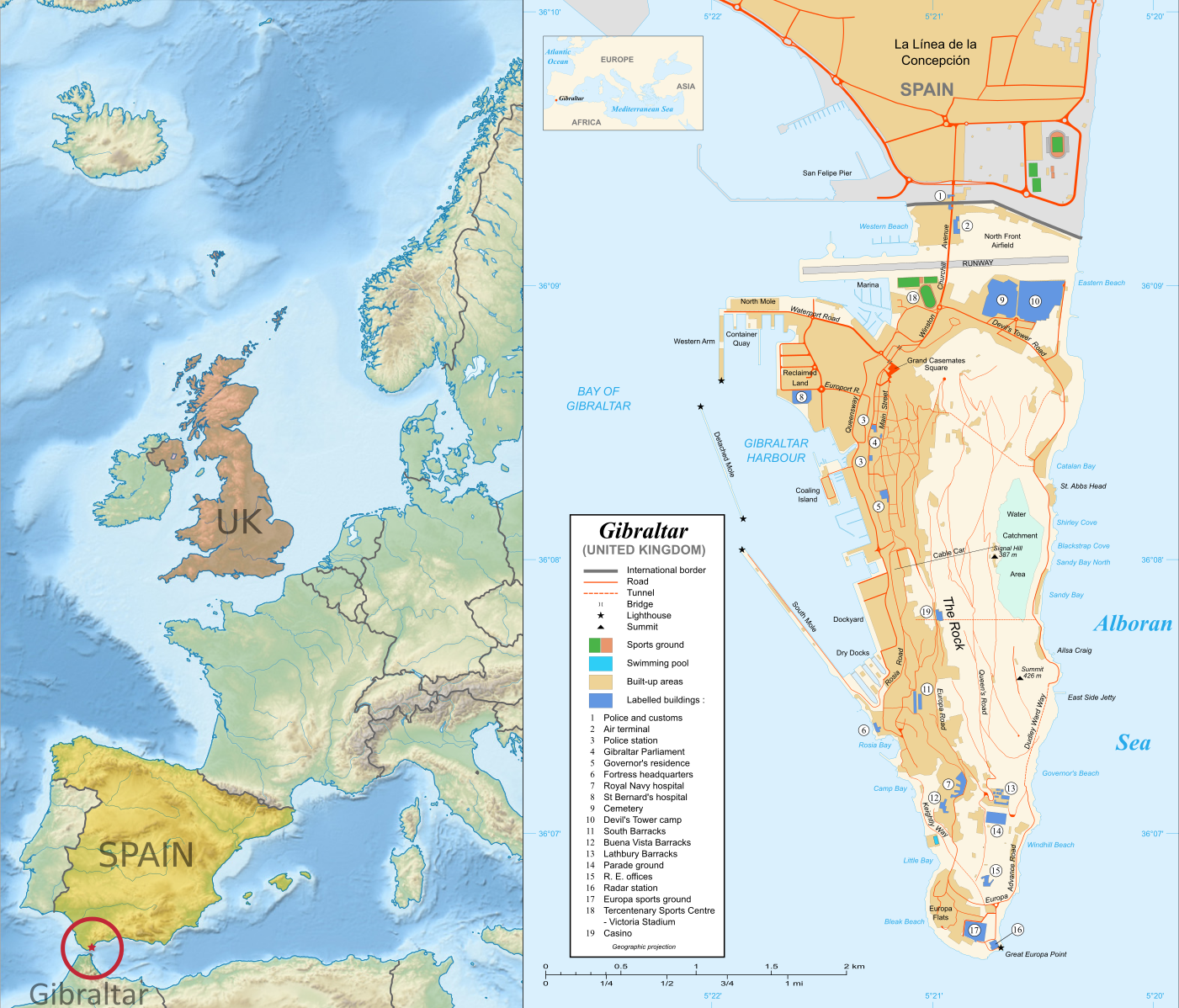 |
| Right: Map of Gibraltar by Eric Gaba (source; CC BY-SA) Left: Gibraltar's location in Europe (based on this Wikimedia Commons map by TUBS; CC BY-SA) |
Last month, PolGeoNow's Evan Centanni and Meihsing Kuo visited the small British territory of Gibraltar (pronounced "jih-BRALL-ter"), one month ahead of the UK's referendum on whether to leave or remain in the European Union (EU).
Gibraltar, a tiny peninsula connected to Spain - and claimed by the Spanish government - is the only British overseas territory that's part of the EU. It's also the only external territory whose residents are eligible to vote in the so-called "Brexit" referendum without living in the UK proper. ("Brexit" is an abbreviation for "British exit" from the EU.)
Thursday, March 3, 2016
Map of Temporary Border Controls in the Schengen Area, March 2016
There are newer versions of this map available. To see them, view all Schengen Area articles.
In the companion to this article, we explain in plain English what the Schengen Area is, and which countries are part of it. Here, we present a map of the area's current crisis, showing where border checks have been reintroduced. Details and explanation in the article below.
Subscribers click here to view this article in the ad-free members area. Not a member yet? Learn about PolGeoNow subscriptions!
Article by Evan Centanni
In the companion to this article, we explain in plain English what the Schengen Area is, and which countries are part of it. Here, we present a map of the area's current crisis, showing where border checks have been reintroduced. Details and explanation in the article below.
 |
Map by Evan Centanni, from blank map by Ssolbergj. License: CC BY-SA |
Article by Evan Centanni
Borders Re-emerging Inside the Schengen Area
Over the past months, concern has been rising that Europe's border-free travel zone, known as the Schengen Area, is falling apart. As unprecedented numbers of refugees and other migrants enter the Schengen Area, individual member countries have begun to re-start border checks in the places where they abolished them decades ago. Read on to learn the why, how, and where of the Schengen Area's new border controls!Map of the Schengen Area in March 2016
This is an older version of PolGeoNow's Schengen Area map, preserved for historical reference. To see the latest version, visit our updated Schengen Area explainer article.
 |
| Map by Evan Centanni, from blank map by Ssolbergj. License: CC BY-SA |
Thursday, December 10, 2015
Map: Kazakhstan Joins WTO
Premium members click here to view this article in the ad-free members area. Not a member yet? Learn about our subscription service!
 |
| Member and observer states of the World Trade Organization (WTO). Map by Evan Centanni, starting from public domain blank map (license: CC BY-NC-SA). |
Friday, October 9, 2015
African Union Suspends Burkina Faso, Then Reinstates it Again (Map)
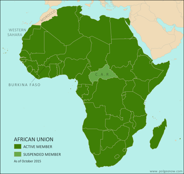 |
| Map by Evan Centanni, from this blank map by Eric Gaba. License: CC BY-SA |
Article by Evan Centanni
Coup Crisis
On September 18, Burkina Faso was suspended from the African Union (AU) by the organization's Peace and Security Council. The action was in response to a government takeover by soldiers loyal to the country's former president Blaise Compaore, who was pushed out in a popular uprising a year ago.
Friday, August 7, 2015
New Olympic Nation: South Sudan (Map)
Paid subscribers click here to view this article in the ad-free members area. Not a member yet? Subscribe now!
 |
| Map of all nations in the Olympics, and their regional associations. Two newest Olympic nations labeled. Map by Evan Centanni, starting from this blank map and modeled after this map. |
Thursday, May 14, 2015
Map: Another Country Joins the "Eurasian Union" (May 2015)
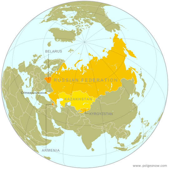 |
| The Eurasian Economic Union's five current member countries, plus disputed Crimea, claimed to be part of Russia. Map by Evan Centanni, starting from this map by Keverich2. License: CC BY-SA |
Subscribe to:
Posts (Atom)