Showing posts with label conflict zones. Show all posts

Friday, December 28, 2018

Syrian Civil War Map & Timeline: IS Loses Western Enclave - December 2018

There are newer versions of this map available. To see them, view all Syria updates.

Map of Syrian Civil War (Syria control map): Territorial control in Syria in December 2018, just before the US troop withdrawal (Free Syrian Army rebels, Kurdish YPG, Syrian Democratic Forces (SDF), Hayat Tahrir al-Sham (HTS / Al-Nusra Front), Islamic State (ISIS/ISIL), and others). Includes US deconfliction zone and Turkey-Russia demilitarized buffer zone, plus recent locations of conflict and territorial control changes, such as Hajin, Al Safa, Baghuz, and more. Colorblind accessible.
Base map by Koen Adams of onestopmap.com, with territorial control by Evan Centanni and Djordje Djukic.
Contact us for permission to use this map.
(Subscribers click here to view this article on the member site)

Timeline by Djordje Djukic

Syria: Where Things Stand Now

In the month and a half since our previous Syria control map report, the main territorial changes have been losses by the so-called "Islamic State" (IS; formerly ISIS/ISIL). The Assad government has eliminated the last pocket of IS control in western Syria, in the south's Al Safa area, and the Kurdish-led Syrian Democratic Forces (SDF) have recaptured the town of Hajin in the east, while also driving IS once again off of the Syria-Iraq border.

Saturday, December 8, 2018

Yemen Control Map & Report: Battle of Hodeida Begins - December 2018 (Subscription)

SUBSCRIBERS CLICK HERE TO PROCEED TO ARTICLE AND MAP

There are newer versions of this map available. To see them, view all Yemen articles on PolGeoNow.

Map of what is happening in Yemen as of December 6, 2018, including territorial control for the unrecognized Houthi government and former president Saleh's forces, president-in-exile Hadi and his allies in the Saudi-led coalition and Southern Movement, Al Qaeda in the Arabian Peninsula (AQAP), and the so-called Islamic State (ISIS/ISIL). Includes recent locations of fighting, including Hodeida, Malahith, Baqim, and more. Colorblind accessible.
Subscribe for full access to all conflict map reports!

Timeline by Djordje Djukic. Map by Evan Centanni, Djordje Djukic, and onestopmap.com


After the pro-Hadi coalition's months of stop-and-go movement towards the Houthi-held port city of Hodeida, the battle has finally moved into the city itself. Meanwhile, fighting has also continued along the Saudi border.

See all this and more on the newest update to PolGeoNow's Yemen territorial control map, which includes a timeline of changes and important events since our previous Yemen map report in September.

This map and report are premium content available to paid subscribers of the PolGeoNow Conflict Mapping Service.

Want to see before you buy? Check out our most recent FREE SAMPLE Yemen map report!

Exclusive report includes:
  • Up-to-date map of current territorial control in Yemen, color-coded for the pro-Hadi coalition, Houthi forces, Al Qaeda in the Arabian Peninsula (AQAP), and the so-called "Islamic State" (ISIS/ISIL)
  • Detailed indication of town-by-town control, including provincial boundaries, all major cities, and many smaller ones
  • Markers for recent areas of fighting, including Hodeida, Malahith, Baqim, and more
  • Timeline of changes to the situation since September 12, 2018, with links to sources

SUBSCRIBERS CLICK HERE TO PROCEED TO ARTICLE AND MAP

Not a member yet? Click here to learn more about our professional subscription service!

Can I purchase just this map?
This map and report are not available for automated purchase to non-subscribers. If you need access or republication rights for only this map report, contact service@polgeonow.com for options.

Thursday, November 29, 2018

Afghanistan: Map of Taliban Control in April 2014

There are newer versions of this map available. To see them, view all Afghanistan updates.

Welcome to PolGeoNow's brand new series of Afghanistan control maps! In the coming months, we'll publish more maps spanning the gap between 2014 and 2018, leading into routine updates of the current situation. To secure your access to all future installments, sign up now for our professional conflict map subscription service!

Where in Afghanistan is the war? Map of Taliban control in Afghanistan in April 2014, after the troop surge and before withdrawal was completed. Also marks areas of government control and unclear or mixed control. Includes all of Afghanistan's major cities, plus selected towns, including the four districts known to be controlled by the Taliban at the time: Dishu and Baghran in Helmand province, Kakar (Khak-e-Afghan) in Zabul province, and Nawa in Ghazni province. Colorblind accessible.
Basemap by Koen Adams of onestopmap.com, with territorial control by Evan Centanni.
This map has been slightly revised. You can see the original here. Contact us for permission to use this map.
(Subscribers click here to view this article on the member site)

Article by Evan Centanni

Afghanistan: Who Controlled What in 2014?

The date is April 5, 2014. It's been more than 12 years since a US-led invasion helped overthrow the Taliban's Islamic Emirate of Afghanistan, a religious hardline government that ruled most of the mountainous country from 1996 to 2001. Its successor, the NATO-backed Islamic Republic of Afghanistan, is voting today on a replacement for President Hamid Karzai, who has led the country ever since the Taliban government's fall in 2001.

Thursday, November 15, 2018

Somalia Control Map & Timeline - November 2018 (Subscription)

SUBSCRIBERS CLICK HERE TO PROCEED TO ARTICLE AND MAP

There are newer versions of this map available. To see them, view all Somalia articles on PolGeoNow.

Map by onestopmap.com, Evan Centanni, and Djordje Djukic

Subscribe for full access to all conflict map reports!

Who controls Somalia? Map (2018). With states, regions, and territorial control. Best Somalia control map online, thoroughly researched, detailed but concise. Shows territorial control by Federal Government of Somalia (FGS), Al Shabaab, so-called Islamic State (ISIS/ISIL), separatist Somaliland, and autonomous states Puntland, Galmudug, and Khatumo. Updated to November 14, 2018. Colorblind accessible.
Since our last update in June, Somalia's civil war has continued at its usual pace, with both Al Qaeda affiliate Al Shabaab and the Mogadishu-based government coalition capturing towns from each other. Meanwhile, the armies of Somaliland and Puntland in the north are still facing off over their disputed border.

See all this and more on the latest update to PolGeoNow's concise, professional Somalia control map, which includes a timeline of changes since our previous Somalia map report of June 2018, with sources cited.

This map and report are premium content, available to paid subscribers of the PolGeoNow Conflict Mapping Service.

Want to see before you subscribe? Check out our most recent FREE SAMPLE Somalia map!

Exclusive map report includes:
  • Up-to-date illustration of current territorial control in Somalia, color-coded for the federal government coalition (including AMISOM peacekeepers), autonomous unionist forces, separatist Somaliland, Al Qaeda affiliate Al Shabaab, and fighters aligned to the so-called "Islamic State" (ISIS/ISIL). Areas of lawlessness or unclear control indicated separately. Colorblind accessible.
  • Boundaries and labels for Somalia's official regions, plus control lines for the autonomous administrations of Somaliland, Puntland, Galmudug, and Khatumo.
  • Detailed indication of city-by-city control, including many relevant smaller towns and villages.
  • Locations of recent fighting and other important events, including Tukaraq, Bar Sanguni, Basra, and more.
  • Detailed timeline of territorial control changes and key political developments since June 2, 2018, with sources indicated. 
  • Brief summary of the conflict situation, as well as major changes to the alignment of autonomous administrations, over the past five and a half months.

SUBSCRIBERS CLICK HERE TO PROCEED TO ARTICLE AND MAP

Not signed up yet? Click here to learn more about our professional subscription service!

Sunday, November 11, 2018

Syrian Civil War Map & Timeline: IS Regains Towns in East - November 2018 (Subscription)

SUBSCRIBERS CLICK HERE TO PROCEED TO ARTICLE AND MAP

There are newer versions of this map available. To see them, view all Syria updates.

Research by Djordje Djukic. Map by onestopmap.com, Evan Centanni, and Djordje Djukic

Subscribe for full access to all conflict map reports!

Map of Syrian Civil War (Syria control map): Territorial control in Syria in November 2018 (Free Syrian Army rebels, Kurdish YPG, Syrian Democratic Forces (SDF), Hayat Tahrir al-Sham (HTS / Al-Nusra Front), Islamic State (ISIS/ISIL), and others). Includes US deconfliction zone and Turkey-Russia demilitarized buffer zone, plus recent locations of conflict and territorial control changes, such as Hajin, Al Safa, Baghuz, and more. Colorblind accessible. 
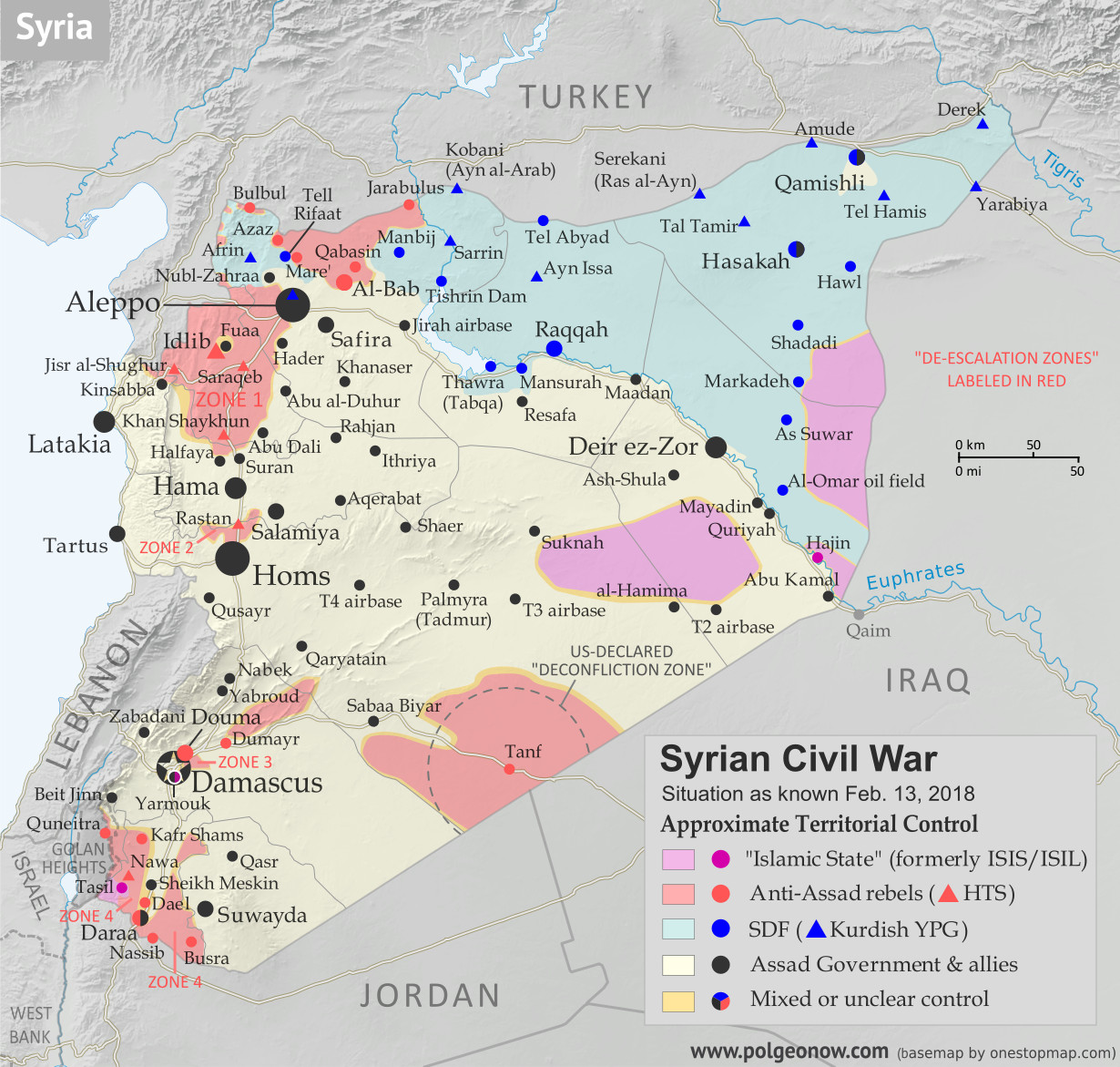
In the past month, a demilitarized buffer zone along government-rebel front lines has gone into partial effect in Syria's northwest. In the southeast, meanwhile, the so-called "Islamic State" (ISIS/ISIL) has reversed recent territorial gains by the US-backed Syrian Democratic Forces.

See all this and more on the latest update to PolGeoNow's concise, professional Syrian Civil War control map, which includes a timeline of changes since our previous Syria map report in October, with sources cited.

This map and report are premium content, available to paid subscribers of the PolGeoNow Conflict Mapping Service.

Want to see before you subscribe? Check out our most recent FREE SAMPLE Syria map!

Exclusive map report includes:
  • Up-to-date illustration of current territorial control in Syria, color-coded for the Assad government, rebel groups, "Islamic State" (ISIS/ISIL) fighters, and the Kurdish-led Syrian Democratic Forces (SDF). Colorblind accessible.
  • The location of the new demilitarized buffer zone sponsored by Turkey and Russia
  • Outline showing the approximate location of the one publicly-known US "deconfliction zone"
  • Special symbols indicating towns dominated by rebels of the former Al Qaeda Nusra Front (now Hayat Tahrir al-Sham or HTS) and by the Kurdish YPG militia (part of the US-backed SDF).
  • Detailed indication of city-by-city control, including key towns and other locations important to current events.
  • Locations of recent control changes and other important events, including Hajin, Al Safa, Baghuz, and more.
  • Detailed timeline of important events and changes to territorial control since October 2, 2018, compiled by our Syria-Iraq expert, with links to sources. 

SUBSCRIBERS CLICK HERE TO PROCEED TO ARTICLE AND MAP

Not signed up yet? Click here to learn more about our professional subscription service!

Can I purchase just this map?
This map and report are not available for automated purchase to non-subscribers. If you need access or republication rights for only this map report, contact service@polgeonow.com for options.

Tuesday, October 2, 2018

Syrian Civil War Map & Timeline - October 2018 (Subscription)

SUBSCRIBERS CLICK HERE TO PROCEED TO ARTICLE AND MAP

There are newer versions of this map available. To see them, view all Syria updates.

Research by Djordje Djukic. Map by onestopmap.com, Evan Centanni, and Djordje Djukic

Subscribe for full access to all conflict map reports!

Map of Syrian Civil War (Syria control map): Territorial control in Syria in October 2018 (Free Syrian Army rebels, Kurdish YPG, Syrian Democratic Forces (SDF), Hayat Tahrir al-Sham (HTS / Al-Nusra Front), Islamic State (ISIS/ISIL), and others). Includes US deconfliction zone, plus recent locations of conflict and territorial control changes, such as Hajin, Al Safa, Baghuz, and more. Colorblind accessible. In the past month, Syria has mostly seen a break in rebel vs. government fighting, with an anticipated offensive against rebel-held Idlib province delayed amid humanitarian concerns and Turkish opposition. However, the so-called "Islamic State" (ISIS/ISIL) has continued losing ground to both the Assad government and the Kurdish-led Syrian Democratic Forces.

See all this and more on the latest update to PolGeoNow's concise, professional Syrian Civil War control map, which includes a timeline of changes since our previous Syria map report in August, with sources cited.

This map and report are premium content, available to paid subscribers of the PolGeoNow Conflict Mapping Service.

Want to see before you subscribe? Check out our most recent FREE SAMPLE Syria map!

Exclusive map report includes:
  • Up-to-date illustration of current territorial control in Syria, color-coded for the Assad government, rebel groups, "Islamic State" (ISIS/ISIL) fighters, and the Kurdish-led Syrian Democratic Forces (SDF). Colorblind accessible.
  • Outline showing the approximate location of the one publicly-known US "deconfliction zone".
  • Special symbols indicating towns dominated by rebels of the former Al Qaeda Nusra Front (now Hayat Tahrir al-Sham or HTS) and by the Kurdish YPG militia (part of the US-backed SDF).
  • Detailed indication of city-by-city control, including key towns and other locations important to current events.
  • Locations of recent control changes and other important events, including Hajin, Al Safa, Baghuz, and more.
  • Detailed timeline of important events and changes to territorial control since August 30, 2018, compiled by our Syria-Iraq expert, with links to sources. 

SUBSCRIBERS CLICK HERE TO PROCEED TO ARTICLE AND MAP

Not signed up yet? Click here to learn more about our professional subscription service!

Can I purchase just this map?
This map and report are not available for automated purchase to non-subscribers. If you need access or republication rights for only this map report, contact service@polgeonow.com for options.

Saturday, September 15, 2018

Yemen Control Map & Report - September 2018 (Subscription)

SUBSCRIBERS CLICK HERE TO PROCEED TO ARTICLE AND MAP

(To see other maps in this series, view all Yemen articles on PolGeoNow.)

Map of what is happening in Yemen as of September 12, 2018, including territorial control for the unrecognized Houthi government and former president Saleh's forces, president-in-exile Hadi and his allies in the Saudi-led coalition and Southern Movement, Al Qaeda in the Arabian Peninsula (AQAP), and the so-called Islamic State (ISIS/ISIL). Includes recent locations of fighting, including Hodeida, Al Tuhayata, Hayran, Malahith, Malajeem, and more. Colorblind accessible.
Subscribe for full access to all conflict map reports!

Timeline by Djordje Djukic. Map by Evan Centanni, Djordje Djukic, and onestopmap.com

Since June, anti-Houthi forces have continued chipping away at Houthi control near the port city of Hodeida and along the border with Saudi Arabia. This comes even as sharp divisions remain in Aden between Saudi-backed Hadi loyalists and UAE-backed southern separatists, both of whom are formally members of the coalition.

See all this and more on the newest update to PolGeoNow's Yemen territorial control map, which includes a timeline of changes and important events since our previous Yemen map report in June.

This map and report are premium content available to paid subscribers of the PolGeoNow Conflict Mapping Service.

Want to see before you buy? Check out our most recent FREE SAMPLE Yemen map report!

Exclusive report includes:
  • Up-to-date map of current territorial control in Yemen, color-coded for the pro-Hadi coalition, Houthi forces, Al Qaeda in the Arabian Peninsula (AQAP), and the so-called "Islamic State" (ISIS/ISIL)
  • Detailed indication of town-by-town control, including provincial boundaries, all major cities, and many smaller ones
  • Markers for recent areas of fighting, including Hodeida, Al Tuhayata, Hayran, Malahith, Malajeem, and more
  • Timeline of changes to the situation since June 16, 2018, with links to sources

SUBSCRIBERS CLICK HERE TO PROCEED TO ARTICLE AND MAP

Not a member yet? Click here to learn more about our professional subscription service!

Can I purchase just this map?
This map and report are not available for automated purchase to non-subscribers. If you need access or republication rights for only this map report, contact service@polgeonow.com for options.

Friday, August 31, 2018

Syrian Civil War Map & Timeline: Assad Retakes Southwest Borders - August 2018 (Subscription)

SUBSCRIBERS CLICK HERE TO PROCEED TO ARTICLE AND MAP

There are newer versions of this map available. To see them, view all Syria updates.

Research by Djordje Djukic. Map by onestopmap.com, Evan Centanni, and Djordje Djukic

Subscribe for full access to all conflict map reports!

Map of Syrian Civil War (Syria control map): Fighting and territorial control in Syria in August 2018 (Free Syrian Army rebels, Kurdish YPG, Syrian Democratic Forces (SDF), Hayat Tahrir al-Sham (HTS / Al-Nusra Front), Islamic State (ISIS/ISIL), and others). Includes US deconfliction zone, plus recent locations of conflict and territorial control changes, such as Quneitra, Tasil, Al Safa, Al Kara'a, and more. Colorblind accessible. 
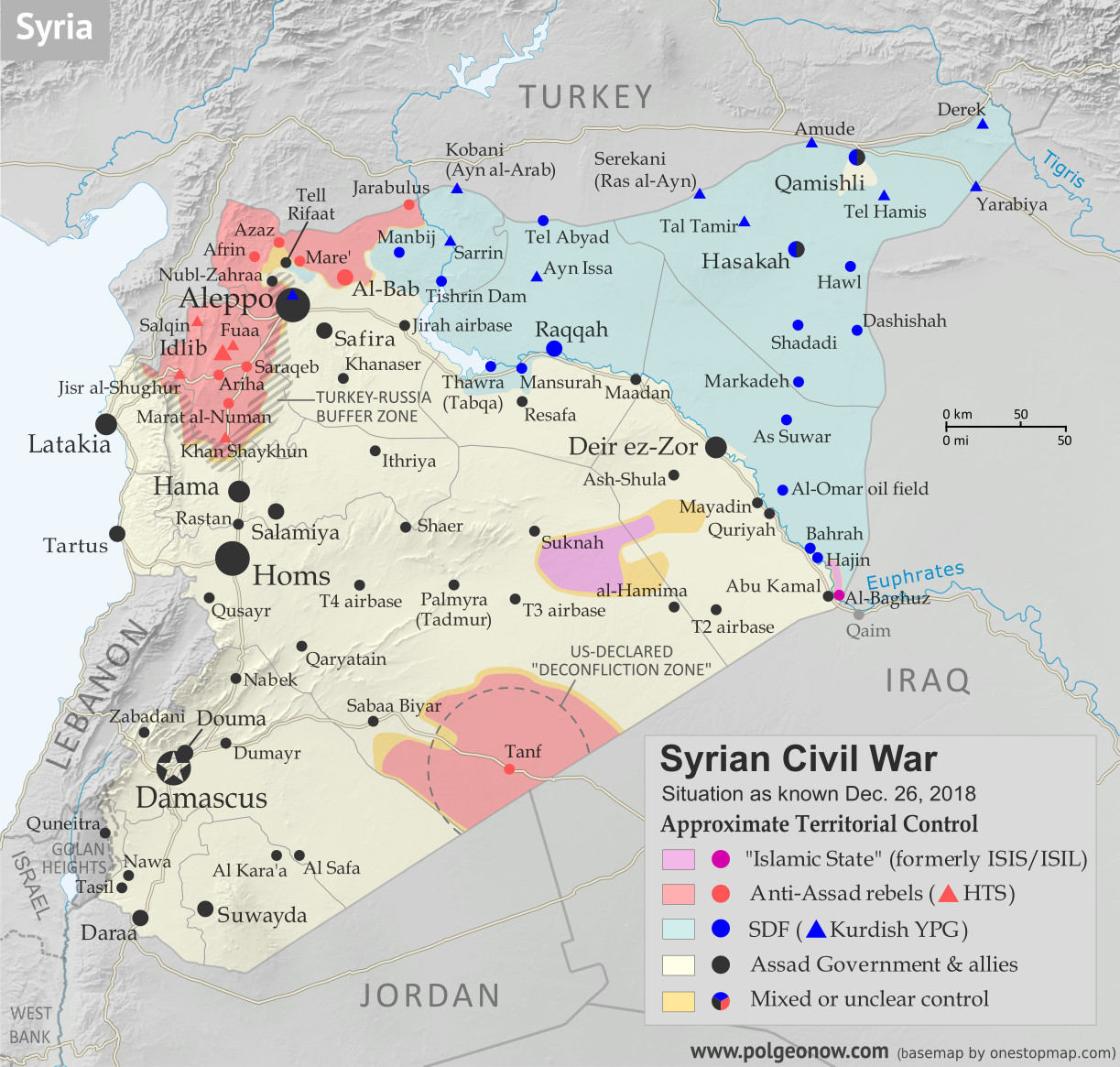
Since late July, Syria's Assad government and allies have completely eliminated both rebel and so-called "Islamic State" (IS; formerly ISIS/ISIL) control of the southwestern border area next to Israel and Jordan. IS has also lost territory elsewhere in the southwest and in Syria's far eastern desert regions.

See all this and more on the latest update to PolGeoNow's concise, professional Syrian Civil War control map, which includes a timeline of changes since our previous Syria map report in July, with sources cited.

This map and report are premium content, available to paid subscribers of the PolGeoNow Conflict Mapping Service.

Want to see before you subscribe? Check out our most recent FREE SAMPLE Syria map!

Exclusive map report includes:
  • Up-to-date illustration of current territorial control in Syria, color-coded for the Assad government, rebel groups, "Islamic State" (ISIS/ISIL) fighters, and the Kurdish-led Syrian Democratic Forces (SDF). Colorblind accessible.
  • Markers showing the approximate locations of Russian-Turkish-Iranian "de-escalation zones" and the one known US "deconfliction zone".
  • Special symbols indicating towns dominated by rebels of the former Al Qaeda Nusra Front (now Hayat Tahrir al-Sham or HTS) and by the Kurdish YPG militia (part of the US-backed SDF).
  • Detailed indication of city-by-city control, including key towns and other locations important to current events.
  • Locations of recent control changes and other important events, including Quneitra, Tasil, Al Safa, Al Kara'a, and more.
  • Detailed timeline of important events and changes to territorial control since July 25, 2018, compiled by our Syria-Iraq expert, with links to sources. 
  • Brief summary of the current situation and of major changes to the configuration of territorial boundaries and de facto enclaves and exclaves.

SUBSCRIBERS CLICK HERE TO PROCEED TO ARTICLE AND MAP

Not signed up yet? Click here to learn more about our professional subscription service!

Can I purchase just this map?
This map and report are not available for automated purchase to non-subscribers. If you need access or republication rights for only this map report, contact service@polgeonow.com for options.

Wednesday, July 25, 2018

Syrian Civil War Map & Timeline: Rebels Lose Daraa Province - July 2018 (Subscription)

SUBSCRIBERS CLICK HERE TO PROCEED TO ARTICLE AND MAP

There are newer versions of this map available. To see them, view all Syria updates.

Research by Djordje Djukic. Map by onestopmap.com, Evan Centanni, and Djordje Djukic

Subscribe for full access to all conflict map reports!

Map of Syrian Civil War (Syria control map): Fighting and territorial control in Syria in July 2018 (Free Syrian Army rebels, Kurdish YPG, Syrian Democratic Forces (SDF), Hayat Tahrir al-Sham (HTS / Al-Nusra Front), Islamic State (ISIS/ISIL), and others). Includes Russia-Turkey-Iran agreed de-escalation zones and US deconfliction zone, plus recent locations of conflict and territorial control changes, such as Daraa, the Golan Heights, Busra, Nawa, Fuaa, and more. Colorblind accessible. Since late June, a rapid government offensive has completely driven rebels out of southwestern Syria's Daraa province, which they had controlled about half of. 

Meanwhile, the government has surrendered an enclave of control within rebel-held northwestern Syria, and the so-called "Islamic State" (ISIS/ISIL) is struggling to hold onto pockets of territory both east and west.

See all this and more on the latest update to PolGeoNow's concise, professional Syrian Civil War control map, which includes a timeline of changes since our previous Syria map report in June, with sources cited.

This map and report are premium content, available to paid subscribers of the PolGeoNow Conflict Mapping Service.

Want to see before you subscribe? Check out our most recent FREE SAMPLE Syria map!

Exclusive map report includes:
  • Up-to-date illustration of current territorial control in Syria, color-coded for the Assad government, rebel groups, "Islamic State" (ISIS/ISIL) fighters, and the Kurdish-led Syrian Democratic Forces (SDF). Colorblind accessible.
  • Markers showing the approximate locations of Russian-Turkish-Iranian "de-escalation zones" and the one known US "deconfliction zone".
  • Special symbols indicating towns dominated by rebels of the former Al Qaeda Nusra Front (now Hayat Tahrir al-Sham or HTS) and by the Kurdish YPG militia (part of the US-backed SDF).
  • Detailed indication of city-by-city control, including key towns and other locations important to current events.
  • Locations of recent control changes and other important events, including Daraa, the Golan Heights, Busra, Nawa, Fuaa, and more.
  • Detailed timeline of important events and changes to territorial control since June 21, 2018, compiled by our Syria-Iraq expert, with links to sources. 
  • Brief summary of the current situation and of major changes to the configuration of territorial boundaries and de facto enclaves and exclaves.

SUBSCRIBERS CLICK HERE TO PROCEED TO ARTICLE AND MAP

Not signed up yet? Click here to learn more about our professional subscription service!

Can I purchase just this map?
This map and report are not available for automated purchase to non-subscribers. If you need access or republication rights for only this map report, contact service@polgeonow.com for options.

Friday, July 20, 2018

Libyan Civil War Map & Timeline - July 2018

There are newer versions of this map available. To see them, view all Libya updates.

Libya: Who controls what? A concise, professional map of of who controls Libya now (July 2018). Shows detailed territorial control in the Libyan Civil War as of July 19, 2018, including all major parties (Government of National Accord (GNA); Tobruk House of Representatives, General Haftar's Libyan National Army (LNA), and allies; Tuareg and Toubou (Tebu) militias in the south; the so-called Islamic State (ISIS/ISIL); and other groups such as the National Salvation Government(NSG) and religious hardline groups). Includes terrain and major roads. Colorblind accessible.
Base map by Koen Adams of onestopmap.com, with territorial control by Evan Centanni and Djordje Djukic. All rights reserved.

(Subscribers click here to view this article on the member site)

Timeline by Djordje Djukic

Libya: Who Controls What?

Ten months after our previous Libya control map and report, the country remains divided between two major rival governments and several smaller groups, but there have been a few changes to their areas of control. This is the first free edition of our map that also shows the territories of the Toubou and Tuareg militias in Libya's south, which align on and off with the country's two major governments.

Saturday, June 23, 2018

Syrian Civil War Map & Timeline: June 2018 (Subscription)

SUBSCRIBERS CLICK HERE TO PROCEED TO ARTICLE AND MAP

There are newer versions of this map available. To see them, view all Syria updates.

Research by Djordje Djukic. Map by onestopmap.com, Evan Centanni, and Djordje Djukic

Subscribe for full access to all conflict map reports!

Map of Syrian Civil War (Syria control map): Fighting and territorial control in Syria in June 2018 (Free Syrian Army rebels, Kurdish YPG, Syrian Democratic Forces (SDF), Hayat Tahrir al-Sham (HTS / Al-Nusra Front), Islamic State (ISIS/ISIL), and others). Includes Russia-Turkey-Iran agreed de-escalation zones and US deconfliction zone, plus recent locations of conflict and territorial control changes, such as Dashishah, Al Kara'a, and more. Colorblind accessible. Since late May, fighting between government and rebel forces in Syria has subsided, but battles against the so-called Islamic State (ISIS/ISIL) have continued in both eastern and western parts of the country.

See all this and more on the latest update to PolGeoNow's concise, professional Syrian Civil War control map, which includes a timeline of changes since our previous Syria map report in May, with sources cited.

This map and report are premium content, available to paid subscribers of the PolGeoNow Conflict Mapping Service.

Want to see before you subscribe? Check out our most recent FREE SAMPLE Syria map!

Exclusive map report includes:
  • Up-to-date illustration of current territorial control in Syria, color-coded for the Assad government, rebel groups, "Islamic State" (ISIS/ISIL) fighters, and the Kurdish-led Syrian Democratic Forces (SDF). Colorblind accessible.
  • Markers showing the approximate locations of Russian-Turkish-Iranian "de-escalation zones" and the one known US "deconfliction zone".
  • Special symbols indicating towns dominated by rebels of the former Al Qaeda Nusra Front (now Hayat Tahrir al-Sham or HTS) and by the Kurdish YPG militia (part of the US-backed SDF).
  • Detailed indication of city-by-city control, including key towns and other locations important to current events.
  • Locations of recent control changes and other important events, including Dashishah, Al Kara'a, Manbij, and more.
  • Detailed timeline of important events and changes to territorial control since May 23, 2018, compiled by our Syria-Iraq expert, with links to sources. 
  • Brief summary of the current situation and of major changes to the configuration of territorial boundaries and de facto enclaves and exclaves.

SUBSCRIBERS CLICK HERE TO PROCEED TO ARTICLE AND MAP

Not signed up yet? Click here to learn more about our professional subscription service!

Can I purchase just this map?
This map and report are not available for automated purchase to non-subscribers. If you need access or republication rights for only this map report, contact service@polgeonow.com for options.

Saturday, June 16, 2018

Yemen Control Map & Report - June 2018 (Subscription)

SUBSCRIBERS CLICK HERE TO PROCEED TO ARTICLE AND MAP

There are newer versions of this map available. To see them, view all Yemen articles on PolGeoNow.

Map of what is happening in Yemen as of June 16, 2018, including territorial control for the unrecognized Houthi government and former president Saleh's forces, president-in-exile Hadi and his allies in the Saudi-led coalition and Southern Movement, Al Qaeda in the Arabian Peninsula (AQAP), and the so-called Islamic State (ISIS/ISIL). Includes recent locations of fighting, including Hodeida, Al Faza, Al Tuhayata, and more. Colorblind accessible.
Subscribe for full access to all conflict map reports!

Timeline by Djordje Djukic. Map by Evan Centanni, Djordje Djukic, and onestopmap.com

Since April, Yemen's Saudi-led coalition has resisted increasing internal divisions to gain some ground against the rival Houthi government, as well as Al Qaeda forces in the east. Now, the coalition is making a concerted push to capture the Houthi-held city of Hodeida, Yemen's main port on the Red Sea.

See all this and more on the newest update to PolGeoNow's Yemen territorial control map, which includes a timeline of changes and important events since our previous Yemen map report in April.

This map and report are premium content available to paid subscribers of the PolGeoNow Conflict Mapping Service.

Want to see before you buy? Check out our most recent FREE SAMPLE Yemen map report!

Exclusive report includes:
  • Up-to-date map of current territorial control in Yemen, color-coded for the pro-Hadi coalition, Houthi/Saleh forces, Al Qaeda in the Arabian Peninsula (AQAP), and the so-called "Islamic State" (ISIS/ISIL).
  • Detailed indication of town-by-town control, including provincial boundaries, all major cities, and many smaller ones
  • Markers for recent areas of fighting, including Hodeida, Al Faza, Al Tuhayata, and more
  • Timeline of changes to the situation since April 14, 2018, with links to sources

SUBSCRIBERS CLICK HERE TO PROCEED TO ARTICLE AND MAP

Not a member yet? Click here to learn more about our professional subscription service!

Can I purchase just this map?
This map and report are not available for automated purchase to non-subscribers. If you need access or republication rights for only this map report, contact service@polgeonow.com for options.

Sunday, June 3, 2018

Somalia Control Map & Timeline - June 2018 (Subscription)

SUBSCRIBERS CLICK HERE TO PROCEED TO ARTICLE AND MAP

There are newer version of this map available. To see them, view all Somalia articles on PolGeoNow.

Map by onestopmap.com, Evan Centanni, and Djordje Djukic

Subscribe for full access to all conflict map reports!

Who controls Somalia? Map (2018). With states, regions, and territorial control. Best Somalia control map online, thoroughly researched and detailed but concise. Shows territorial control by Federal Government of Somalia (FGS), Al Shabaab, so-called Islamic State (ISIS/ISIL), separatist Somaliland, and autonomous states Puntland, Galmudug, and Khatumo (the ASWJ Sufi militia has merged with Galmudug state). Updated to June 2, 2018. Colorblind accessible.
In the last two months, several towns in southern Somalia have changed hands between Al Shabaab and government-allied forces, while political realignments have continued to change the country's map of autonomous states.

See all this and more on the latest update to PolGeoNow's concise, professional Somalia control map, which includes a timeline of changes since our previous Somalia map report of March 2018, with sources cited.

This map and report are premium content, available to paid subscribers of the PolGeoNow Conflict Mapping Service.

Want to see before you subscribe? Check out our most recent FREE SAMPLE Somalia map!

Exclusive map report includes:
  • Up-to-date illustration of current territorial control in Somalia, color-coded for the federal government coalition (including AMISOM peacekeepers), autonomous unionist forces, separatist Somaliland, Al Qaeda affiliate Al Shabaab, and fighters aligned to the so-called "Islamic State" (ISIS/ISIL). Areas of lawlessness or unclear control indicated separately. Colorblind accessible.
  • Boundaries and labels for Somalia's official regions, plus control lines for the autonomous administrations of Somaliland, Puntland, Galmudug, and Khatumo.
  • Detailed indication of city-by-city control, including many relevant smaller towns and villages.
  • Locations of recent fighting and other important events, including Tukaraq, Moqokori, Bulo Haji, Bali Khadar, and more.
  • Detailed timeline of territorial control changes and key political developments since March 28, 2018, with sources indicated. 
  • Brief summary of the conflict situation, as well as major changes to the alignment of autonomous administrations, over the past three months.

SUBSCRIBERS CLICK HERE TO PROCEED TO ARTICLE AND MAP

Not signed up yet? Click here to learn more about our professional subscription service!

Friday, May 25, 2018

Syrian Civil War Map & Timeline: Rebels Lose Rastan Enclave - May 2018 (Subscription)

SUBSCRIBERS CLICK HERE TO PROCEED TO ARTICLE AND MAP

There are newer versions of this map available. To see them, view all Syria updates.

Research by Djordje Djukic. Map by onestopmap.com, Evan Centanni, and Djordje Djukic

Subscribe for full access to all conflict map reports!

Map of Syrian Civil War (Syria control map): Fighting and territorial control in Syria in May 2018 (Free Syrian Army rebels, Kurdish YPG, Syrian Democratic Forces (SDF), Hayat Tahrir al-Sham (HTS / Al-Nusra Front), Islamic State (ISIS/ISIL), and others). Includes Russia-Turkey-Iran agreed de-escalation zones and US deconfliction zone, plus recent locations of conflict and territorial control changes, such as Rastan, Yarmouk, Baghuz, and more. Colorblind accessible.
In the past month, Syria's rebels have lost one of their biggest enclaves of control - "Zone 2" near the city of Homs, including their oldest stronghold in Rastan. Meanwhile, the national capital has been completely cleared of rebel and "Islamic State" control pockets.

See all this and more on the latest update to PolGeoNow's concise, professional Syrian Civil War control map, which includes a timeline of changes since our previous Syria map report in April, with sources cited.

This map and report are premium content, available to paid subscribers of the PolGeoNow Conflict Mapping Service.

Want to see before you subscribe? Check out our most recent FREE SAMPLE Syria map!

Exclusive map report includes:
  • Up-to-date illustration of current territorial control in Syria, color-coded for the Assad government, rebel groups, "Islamic State" (ISIS/ISIL) fighters, and the Kurdish-led Syrian Democratic Forces (SDF). Colorblind accessible.
  • Markers showing the approximate locations of Russian-Turkish-Iranian "de-escalation zones" and the one known US "deconfliction zone".
  • Special symbols indicating towns dominated by rebels of the former Al Qaeda Nusra Front (now Hayat Tahrir al-Sham or HTS) and by the Kurdish YPG militia (part of the US-backed SDF).
  • Detailed indication of city-by-city control, including key towns and other locations important to current events.
  • Locations of recent control changes and other important events, including Rastan, Yarmouk, Baghuz, and more.
  • Detailed timeline of important events and changes to territorial control since April 25, 2018, compiled by our Syria-Iraq expert, with links to sources. 
  • Brief summary of the current situation and of major changes to the configuration of territorial boundaries and de facto enclaves and exclaves.

SUBSCRIBERS CLICK HERE TO PROCEED TO ARTICLE AND MAP

Not signed up yet? Click here to learn more about our professional subscription service!

Can I purchase just this map?
This map and report are not available for automated purchase to non-subscribers. If you need access or republication rights for only this map report, contact service@polgeonow.com for options.

Friday, April 27, 2018

Syrian Civil War Map & Timeline: Kurdish, Rebel Enclaves Evaporate - April 2018 (Subscription)

SUBSCRIBERS CLICK HERE TO PROCEED TO ARTICLE AND MAP

There are newer versions of this map available. To see them, view all Syria updates.

Research by Djordje Djukic. Map by onestopmap.com, Evan Centanni, and Djordje Djukic

Subscribe for full access to all conflict map reports!

Map of Syrian Civil War (Syria control map): Fighting and territorial control in Syria in April 2018 (Free Syrian Army rebels, Kurdish YPG, Syrian Democratic Forces (SDF), Hayat Tahrir al-Sham (HTS / Al-Nusra Front), Islamic State (ISIS/ISIL), and others). Includes Russia-Turkey-Iran agreed de-escalation zones and US deconfliction zone, plus recent locations of conflict and territorial control changes, such as Afrin, Douma, Dumayr, Sabaa Biyar, and more. Colorblind accessible.
In the last six weeks, Turkey-led forces have expelled the Kurdish YPG from its stronghold in Afrin, while the three major pockets of rebel control near Damascus have all been wiped off the map.

See all this and more on the latest update to PolGeoNow's concise, professional Syrian Civil War control map, which includes a timeline of changes since our previous Syria map report in March, with sources cited.

This map and report are premium content, available to paid subscribers of the PolGeoNow Conflict Mapping Service.

Want to see before you subscribe? Check out our most recent FREE SAMPLE Syria map!

Exclusive map report includes:
  • Up-to-date illustration of current territorial control in Syria, color-coded for the Assad government, rebel groups, "Islamic State" (ISIS/ISIL) fighters, and the Kurdish-led Syrian Democratic Forces (SDF). Colorblind accessible.
  • Markers showing the approximate locations of Russian-Turkish-Iranian "de-escalation zones" and the one known US "deconfliction zone".
  • Special symbols indicating towns dominated by rebels of the former Al Qaeda Nusra Front (now Hayat Tahrir al-Sham or HTS) and by the Kurdish YPG militia (part of the US-backed SDF).
  • Detailed indication of city-by-city control, including key towns and other locations important to current events.
  • Locations of recent fighting and other important events, including Afrin, Douma, Dumayr, Sabaa Biyar, and more.
  • Detailed timeline of important events and changes to territorial control since March 16, 2018, compiled by our Syria-Iraq expert, with links to sources. 
  • Brief summary of current situation, as well as major changes to the configuration of territorial boundaries and de facto enclaves and exclaves.

SUBSCRIBERS CLICK HERE TO PROCEED TO ARTICLE AND MAP

Not signed up yet? Click here to learn more about our professional subscription service!

Can I purchase just this map?
This map and report are not available for automated purchase to non-subscribers. If you need access or republication rights for only this map report, contact service@polgeonow.com for options.

Sunday, April 15, 2018

Yemen Control Map & Report - April 2018 (Subscription)

SUBSCRIBERS CLICK HERE TO PROCEED TO ARTICLE AND MAP

There are newer versions of this map available. To see them, view all Yemen articles on PolGeoNow.
 
Map of what is happening in Yemen as of May 21, 2017, including territorial control for the unrecognized Houthi government and former president Saleh's forces, president-in-exile Hadi and his allies in the Saudi-led coalition and Southern Movement, Al Qaeda in the Arabian Peninsula (AQAP), and the so-called Islamic State (ISIS/ISIL). Includes recent locations of fighting, including Azzan, Habban, Maydee, Nihm, and more.
Subscribe for full access to all conflict map reports!

Timeline by Djordje Djukic. Map by Evan Centanni, Djordje Djukic, and onestopmap.com

In the past three months, the civil war in Yemen has been marked by infighting within the Saudi-led coalition, while those forces have made only small progress against the Houthis and Al Qaeda.

See all this and more on the newest update to PolGeoNow's Yemen territorial control map, which includes a timeline of changes and important events since our previous Yemen map report in January.

This map and report are premium content available to paid subscribers of the PolGeoNow Conflict Mapping Service.

Want to see before you buy? Check out our most recent FREE SAMPLE Yemen map report!

Exclusive report includes:
  • Up-to-date map of current territorial control in Yemen, color-coded for the pro-Hadi coalition, Houthi/Saleh forces, Al Qaeda in the Arabian Peninsula (AQAP), and the so-called "Islamic State" (ISIS/ISIL).
  • Detailed indication of town-by-town control, including provincial boundaries, all major cities, and many smaller ones
  • Markers for recent areas of fighting, including Hays, Kirsh, Nihm, Ketaf, and more
  • Timeline of changes to the situation since January 6, 2018, with links to sources

SUBSCRIBERS CLICK HERE TO PROCEED TO ARTICLE AND MAP

Not a member yet? Click here to learn more about our professional subscription service!

Can I purchase just this map?
This map and report are not available for automated purchase to non-subscribers. If you need access or republication rights for only this map report, contact service@polgeonow.com for options.

Wednesday, March 28, 2018

Somalia Control Map & Timeline - March 2018 (Subscription)

SUBSCRIBERS CLICK HERE TO PROCEED TO ARTICLE AND MAP

There are newer versions of this map available. To see them, view all Somalia articles on PolGeoNow.

Map by onestopmap.com, Evan Centanni, and Djordje Djukic

Subscribe for full access to all conflict map reports!

Who controls Somalia? Map (2018). With states, regions, and territorial control. Best Somalia control map online, thoroughly researched and detailed but concise. Shows territorial control by Federal Government of Somalia (FGS), Al Shabaab, so-called Islamic State (ISIS/ISIL), separatist Somaliland, and autonomous states Puntland, Galmudug, Khatumo, and the ASWJ Sufi militia. Updated to March 28, 2018. Colorblind accessible.
Since last summer, Al Qaeda's Al Shabaab affiliate has lost some key towns in Somalia, but also had some victories - all this amid increasing US military involvement. Meanwhile, two pairs of rival governments farther north are moving towards unification.

See all this and more on the latest update to PolGeoNow's concise, professional Somalia control map, which includes a timeline of changes since our previous Somalia map report of August 2017, with sources cited.

This map and report are premium content, available to paid subscribers of the PolGeoNow Conflict Mapping Service.

Want to see before you subscribe? Check out our most recent FREE SAMPLE Somalia map!

Exclusive map report includes:
  • Up-to-date illustration of current territorial control in Somalia, color-coded for the federal government coalition (including AMISOM peacekeepers), autonomous unionist forces, separatist Somaliland, Al Qaeda affiliate Al Shabaab, and fighters aligned to the so-called "Islamic State" (ISIS/ISIL). Areas of lawlessness and unclear control also clearly marked. Colorblind accessible.
  • Boundaries and labels for Somalia's official regions, plus control lines for the autonomous administrations of Somaliland, Puntland, Galmudug, ASWJ, and Khatumo.
  • Detailed indication of city-by-city control, including many relevant smaller towns and villages.
  • Locations of recent fighting and other important events, including Bariire, Basra, Sablale, Torotorow, Tukaraq, and more.
  • Detailed timeline of territorial control changes and key political developments since August 25, 2017, with sources indicated. 
  • Brief summary of the conflict situation, as well as major changes to the alignment of autonomous administrations, over the past seven months.

SUBSCRIBERS CLICK HERE TO PROCEED TO ARTICLE AND MAP

Not signed up yet? Click here to learn more about our professional subscription service!

Sunday, March 18, 2018

Syrian Civil War Map & Timeline: Afrin Separated from Turkey - March 2018 (Subscription)

SUBSCRIBERS CLICK HERE TO PROCEED TO ARTICLE AND MAP

There are newer versions of this map available. To see them, view all Syria updates.

Research by Djordje Djukic. Map by onestopmap.com, Evan Centanni, and Djordje Djukic

Subscribe for full access to all conflict map reports!

Map of Syrian Civil War (Syria control map): Fighting and territorial control in Syria in March 2018 (Free Syrian Army rebels, Kurdish YPG, Syrian Democratic Forces (SDF), Hayat Tahrir al-Sham (HTS / Al-Nusra Front), Islamic State (ISIS/ISIL), and others). Includes Russia-Turkey-Iran agreed de-escalation zones and US deconfliction zone, plus recent locations of conflict and territorial control changes, such as Afrin, the Eastern Ghouta rebel zone, and more. Colorblind accessible.
Over the past month, fighting has raged in three major flashpoints in Syria, with the Turkish invasion of Afrin, Assad's new ground war against rebels near Damascus, and heavy infighting between rebel groups in the north.

See all this and more on the latest update to PolGeoNow's concise, professional Syrian Civil War control map, which includes a timeline of changes since our previous Syria map report in February, with sources cited.

This map and report are premium content, available to paid subscribers of the PolGeoNow Conflict Mapping Service.

Want to see before you subscribe? Check out our most recent FREE SAMPLE Syria map!

Exclusive map report includes:
  • Up-to-date illustration of current territorial control in Syria, color-coded for the Assad government, rebel groups, "Islamic State" (ISIS/ISIL) fighters, and Kurdish/SDF forces. Colorblind accessible.
  • Markers showing the approximate locations of Russian-Turkish-Iranian "de-escalation zones" and the one known US "deconfliction zone".
  • Special symbols indicating towns dominated by rebels of the former Al Qaeda Nusra Front (now Hayat Tahrir al-Sham or HTS) and by the US-backed Syrian Democratic Forces (SDF).
  • Detailed indication of city-by-city control, including key towns and other locations important to current events.
  • Locations of recent fighting and other important events, including Kurdish Afrin, the Eastern Ghouta rebel zone near Damascus, and more.
  • Detailed timeline of important events and changes to territorial control since February 13, 2018, compiled by our Syria-Iraq expert, with links to sources. 
  • Brief summary of current situation, as well as major changes to the configuration of territorial boundaries and de facto enclaves and exclaves.

SUBSCRIBERS CLICK HERE TO PROCEED TO ARTICLE AND MAP

Not signed up yet? Click here to learn more about our professional subscription service!

Can I purchase just this map?
This map and report are not available for automated purchase to non-subscribers. If you need access or republication rights for only this map report, contact service@polgeonow.com for options.

Saturday, February 24, 2018

Iraq Control Map & Timeline - February 2018 (Subscription)

SUBSCRIBERS CLICK HERE TO PROCEED TO ARTICLE AND MAP

There are newer versions of this map available. To see them, view all Iraq updates.

Research by Djordje Djukic. Map by onestopmap.com, Evan Centanni, and Djordje Djukic

Subscribe for full access to all conflict map reports!

Detailed map of territorial control in Iraq as of February 22, 2018. Shows territory held by the so-called Islamic State (ISIS, ISIL), the Baghdad government, the Kurdistan Peshmerga, and the Yezidi Sinjar Alliance (YBS and YJE). Colorblind accessible.
Since November, pro-government forces in Iraq have nearly, but not entirely, cleared the country of control by the so-called "Islamic State" (ISIS/ISIL), with the group still reportedly holding out in parts of the western desert.

See all this and more on the latest update to PolGeoNow's concise, professional map of control in Iraq's civil war, including a timeline of changes since our previous Iraq map report of November 2017.

This map and report are premium content, available to paid subscribers of the PolGeoNow Conflict Mapping Service.

Want to see before you subscribe? Check out our most recent FREE SAMPLE Iraq map report!

Exclusive report includes:
  • Up-to-date map of current territorial control in Iraq, color-coded for the Iraqi government, "Islamic State" (ISIS/ISIL) fighters, Kurdistan's Peshmerga forces, and Yezidi militias. Colorblind accessible.
  • Detailed indication of town-by-town control, including all major cities and many smaller ones, as well as terrain, major roads, and provincial boundaries
  • Timeline of changes to the situation since the end of November, compiled by our Iraq-Syria specialist, with links to sources.
SUBSCRIBERS CLICK HERE TO PROCEED TO ARTICLE AND MAP

Not signed up yet? Click here to learn more about our professional subscription service!

Can I purchase just this map?
This map and report are not available for automated purchase to non-subscribers. If you need access or republication rights for only this map report, contact service@polgeonow.com for options.

Thursday, February 15, 2018

Syrian Civil War Map & Timeline - February 2018

There are newer versions of this map available. To see them, view all Syria updates.

Who controls what in Syria? Rebel and ISIS control map of the Syrian Civil War. Shows territorial control as of February 2018 (Free Syrian Army rebels, Kurdish YPG, Syrian Democratic Forces (SDF), Jabhat Fateh al-Sham / Hayat Tahrir al-Sham (Al-Nusra Front), Islamic State (ISIS/ISIL), and others). Includes Russia-Turkey-Iran agreed de-escalation zones and US deconfliction zone, plus recent locations of conflict and territorial control changes, such as Abu al-Duhur, Bulbul, Saraqeb, and more. Colorblind accessible.
Base map by Koen Adams of onestopmap.com, with territorial control by Evan Centanni and Djordje Djukic.
Contact us for permission to use this map.
(Subscribers click here to view this article on the member site)

Timeline by Djordje Djukic

Situation Summary

The past few weeks since our previous Syria map update have been dominated by news from two main arenas of battle, both in the country's northwest. In the most politically significant development, the Turkish military has entered the Kurdish-administrated Afrin region (also spelled "Efrin") as part of a mission, alongside allied rebel fighters, to drive Kurdish militias out of the western border region. Meanwhile, forces loyal to Syria's Assad government have made major advances in areas south of Aleppo, eliminating an enclave of the so-called "Islamic State" (IS; formerly ISIS/ISIL) and cutting into rebel control around the edges of Idlib province.