 |
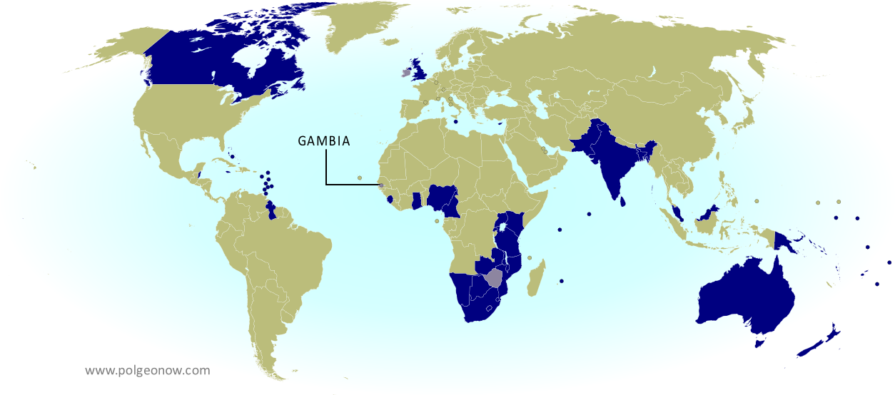
| The Commonwealth of Nations. Current members in dark blue, former members in lavender. Map by Evan Centanni, modified from public domain blank map. |
Updates on the world's countries and borders
Showing posts with label africa. Show all posts
Showing posts with label africa. Show all posts
Tuesday, April 15, 2014
ICYMI: The Gambia's Withdrawal from the Commonwealth
"In case you missed it" - this is an article featuring news we couldn't cover when it first broke, but that we thought you might still want to know about. Those who read our article on the year 2013 in political geography changes already heard about the Gambia's withdrawal from the Commonwealth of Nations - now here's the full story.
Premium members click here to view this article in the ad-free members area. Not a member yet? Subscribe now!
Saturday, March 15, 2014
Madagascar Un-Suspended from African Union
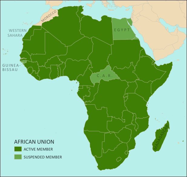 |
| The African Union as of March 2014. Map by Evan Centanni, from this blank map by Eric Gaba. License: CC BY-SA |
Saturday, February 22, 2014
South Sudan War Map: Current Rebel Control (Update #4) (Premium)

Download PDF buy |
To see the map of control at the time of the ceasefire on January 23, see Part 1.
Premium article includes:
- Exclusive map of current rebel control up to February 21, 2014
- Multiple changes to territorial control since previous update
- Several more new locations added to the map
- Report chronicling changes to territorial control since the ceasefire, including links to sources
Members click here to proceed to article and map
Not a member yet? Subscribe Now!
South Sudan War Map: Control at Time of January Ceasefire (Update #3) (Premium)
Download PDF buy |
To see the map of current control as of late February, go to Part 2.
Premium article includes:
- Exclusive map of rebel control at the time the ceasefire was signed on January 23, 2014
- Multiple changes to territorial control since previous update
- Several new locations added to the map
- Report chronicling changes to territorial control and describing the situation at the time of the ceasefire, including links to sources
Members click here to proceed to article and map
Not a member yet? Subscribe Now!
Sunday, January 19, 2014
ICYMI: Cape Verde's Name Change
In the following weeks, PolGeoNow will be publishing several short "in case you missed it (ICYMI)" articles on events from 2013. This is news that we weren't able to cover when it first broke, but that we thought our readers might still want to know about.
Premium members click here to view this article in the ad-free members area. Not a member yet? Subscribe now!
By Evan Centanni
Cape Verde Changes Official Name
If you read our article on the year 2013 in political geography changes, you've already heard about the change to Cape Verde's official English name. But since keeping track of country name changes is one of the primary missions of Political Geography Now, we are now presenting this in-depth report on the topic.
Premium members click here to view this article in the ad-free members area. Not a member yet? Subscribe now!
 |
Cape Verde, now officially Cabo Verde (click to enlarge). Map by Oona Räisänen/Wikimedia (CC BY-SA) (source).
|
Cape Verde Changes Official Name
If you read our article on the year 2013 in political geography changes, you've already heard about the change to Cape Verde's official English name. But since keeping track of country name changes is one of the primary missions of Political Geography Now, we are now presenting this in-depth report on the topic.
Thursday, January 16, 2014
South Sudan Rebellion: Map Update 2 (Premium Content)

Download PDF buy |
Premium article includes:
- Exclusive updated map of rebel control in South Sudan's ongoing uprising (current as of January 16, 2014)
- A number of new localities have been added to the map since last time
- Report chronicling changes to territorial control since the previous map, with links to sources
Members click here to proceed to article and map
Not a member yet? Subscribe Now!
Friday, January 3, 2014
South Sudan: Rebel Control Map Update (Premium Content)
There are newer versions of this map available. To see the full list of updates, view all South Sudan articles.

Since our first map report on rebel control in South Sudan's political crisis, the situation has continued to develop quickly, with several cities and towns changing hands. PolGeoNow now presents an updated map and report exclusively
available as premium content for purchase and to our subscribers. Buy now for only US$2.99!
Premium article includes:
Members click here to proceed to article and map
Not a member yet? Subscribe Now!

Download PDF buy |
Premium article includes:
- Exclusive updated map of rebel control in South Sudan's ongoing uprising
- Report chronicling changes since the previous map, with links to sources
Members click here to proceed to article and map
Not a member yet? Subscribe Now!
Tuesday, December 24, 2013
South Sudan Crisis: Rebel Control Map (Premium Content)
There are newer versions of this map available. To see the full list of updates, view all South Sudan articles.

After a sudden outbreak of political violence last week, the military of South Sudan has fragmented
into two competing factions, with rebellious defectors capturing a
large swath of the world's newest country. PolGeoNow now presents the
first map of rebel control in South Sudan's ongoing crisis, an exclusive
for premium subscribers and purchasers.
Premium article includes:
Not a member yet? Subscribe Now!

Download PDF buy |
Premium article includes:
- Exclusive, up-to-date map of rebel control by state and city in South Sudan's ongoing uprising
- Outline of the course of events so far, including the captures of three state capitals by rebel forces
- Brief description of the causes and humanitarian consequences of the current conflict
Not a member yet? Subscribe Now!
Tuesday, December 3, 2013
DR Congo War: The History of M23 Control (Map)
[Editor's note: This map article was published in late 2013, and was originally intended to be the first piece in PolGeoNow's conflict map subscription service. Subscriber coverage has since refocused on other conflicts, and we're now making this piece free for all readers.]
From 2012 to 2013, the M23 rebels became the Democratic Republic of the Congo's most powerful rebel group in recent history, establishing military control over a major city in country's east. You may have heard how M23 was defeated suddenly in late 2013, but do you know what territory they controlled while they were active? Learn more with this exclusive map of M23's territorial possessions over time, as well as a primer on the group's short history and ultimate defeat.
The March 23 Movement, better known as M23, only appeared in May of 2012. However, it quickly became the most prominent of the many rebel forces operating in the region, carving out its own area of territorial control and proving a match for the Congolese army. In late 2012 it captured Goma, a city of one million and the capital of Congo's North Kivu province. It was eventually crushed in a rapid military campaign by the army and a UN peacekeeper intervention brigade in November 2013.
From 2012 to 2013, the M23 rebels became the Democratic Republic of the Congo's most powerful rebel group in recent history, establishing military control over a major city in country's east. You may have heard how M23 was defeated suddenly in late 2013, but do you know what territory they controlled while they were active? Learn more with this exclusive map of M23's territorial possessions over time, as well as a primer on the group's short history and ultimate defeat.
 |
Map by Evan Centanni (all rights reserved).
|
Congo's War with M23
The Democratic Republic of the Congo - formerly known as Zaire - has been at war for decades. After serving as the stage for a regional conflict partly sparked by the Rwandan Genocide in the mid-1990s, as well as a follow-up war spanning officially from 1998 to 2003, the eastern DRC has become the stomping ground of dozens of rebel groups with often-shifting allegiances.The March 23 Movement, better known as M23, only appeared in May of 2012. However, it quickly became the most prominent of the many rebel forces operating in the region, carving out its own area of territorial control and proving a match for the Congolese army. In late 2012 it captured Goma, a city of one million and the capital of Congo's North Kivu province. It was eventually crushed in a rapid military campaign by the army and a UN peacekeeper intervention brigade in November 2013.
Friday, September 27, 2013
Central African Republic: Towns Retaken by Government-allied Forces (September 2013)
There are newer maps of this conflict available. To see them, view all Central African Republic articles on PolGeoNow.
 |
Counter-rebels briefly captured at least one Central African Republic town in September (click for full map and article). Map by Evan Centanni from this map by Wikimedia user Keitsist. License: CC BY-SA
|
Two weeks ago, Political Geography Now reported on rebel control in the Central African Republic's new counter-rebellion. Since then, the towns of Bouca and Bossangoa have reportedly both been recaptured by forces belonging to Séléka, the former rebel coalition whose leader is now the president of the Central African Republic.
However, as outrage grows over vicious violence against civilians which has continued since Séléka's campaign to take over the Central African Republic earlier this year, the new President Michel Djotodia has little actual control over the country.
One another analyst says that "law and order stops outside the presidential palace" in Bangui, and the AFP reported earlier this month that "A large number of [Séléka] fighters answer only to their direct leaders, who have carved out personal fiefdoms in the wake of the rebellion". This raises serious questions regarding President Djotodia's claims that he is now dissolving and outlawing the Séléka organization.
More information: Rebel Control Map: Central African Republic's Counter-Rebellion
To see Séléka's rise to power illustrated in rebel-control maps, view all Central African Republic articles.
Wednesday, September 11, 2013
Rebel Control Map: Central African Republic's Counter-Rebellion (September 2013)
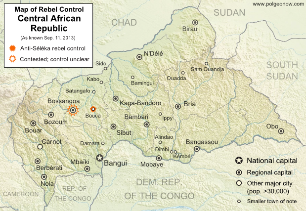 |
Rebellion and Counter-Rebellion
Starting last December, a rebel coalition called Séléka swept across the Central African Republic from the north, capturing much of the country by January (see our first map of rebel control in the CAR). After a short-lived attempt at peace, Séléka renewed its campaign, capturing the capital and forcing President François Bozizé to flee the country. Rebel leader Michel Djotodia declared himself president, and Séléka has remained the major power in the country despite outbreaks of violence and general chaos.
Saturday, July 27, 2013
Mali Conflict Map: National Territory Reunited Ahead of Elections (July 2013)
There are newer versions of this map available. To see them, view all Mali maps.
This is an update within our Mali conflict map series - for the original story, see Mali Map: Islamist Control & French Intervention.
This is an update within our Mali conflict map series - for the original story, see Mali Map: Islamist Control & French Intervention.
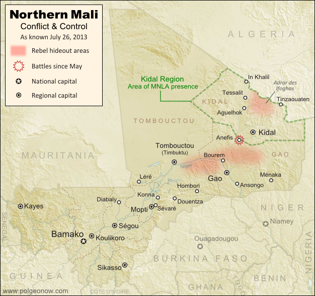 |
Updated map of situation in Mali ahead of elections on July 28, 2013. Map by Evan Centanni, modified from Wikimedia map by Orionist, using images by Carport and NordNordWest (source). License: CC BY-SA.
|
Saturday, July 20, 2013
Nigeria Map Update: War on Boko Haram Continues After Decline in Rebel Control
There are newer versions of this map available. To see them, view all Nigeria updates.
Two months ago, Political Geography Now published a map of Boko Haram rebel control in Nigeria as the government declared a state of emergency and began a large-scale military intervention. We now present an updated map of the continued fighting and attacks following the rebels' apparent loss of any significant territorial control.
Two months ago, Political Geography Now published a map of Boko Haram rebel control in Nigeria as the government declared a state of emergency and began a large-scale military intervention. We now present an updated map of the continued fighting and attacks following the rebels' apparent loss of any significant territorial control.
 |
Map of fighting and attacks in Nigeria's war against the rebels of Boko Haram. Map by Evan Centanni.
|
Thursday, July 11, 2013
Egypt Suspended from African Union
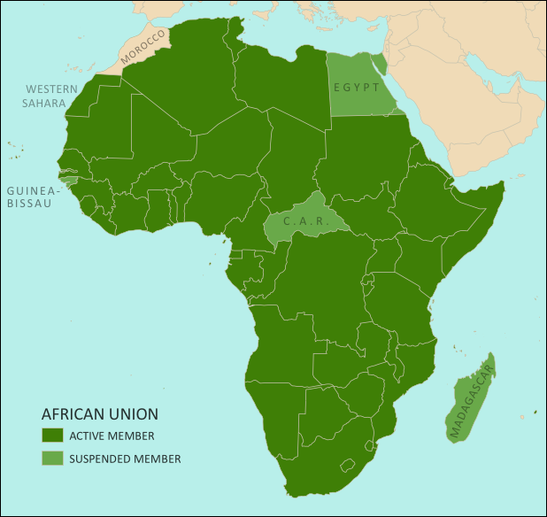 |
| The African Union. Map by Evan Centanni, from this blank map by Eric Gaba. License: CC BY-SA |
Thursday, May 30, 2013
War in Somalia: Map of Al Shabaab Control (June 2013)
There are newer versions of this map available. To see them, view all Somalia articles on PolGeoNow.
Since the beginning of the year, Somalia's federal government and its allies have made some major breakthroughs in the war to take back the country from Al Shabaab, Somalia's local branch of Al Qaeda. This is the third installment in our series of Al Shabaab control maps, marking territorial changes since our last Somalia map update in December 2012.
Connecting Mogadishu and Baidoa
After news came in of the Somali Federal Government and its allies completing their control of southern Somalia's major cities last fall, further progress against the Al Qaeda affiliate group Al Shabaab at first made only slow progress. But since the beginning of this year, at least one major breakthrough has been made.
Since the beginning of the year, Somalia's federal government and its allies have made some major breakthroughs in the war to take back the country from Al Shabaab, Somalia's local branch of Al Qaeda. This is the third installment in our series of Al Shabaab control maps, marking territorial changes since our last Somalia map update in December 2012.
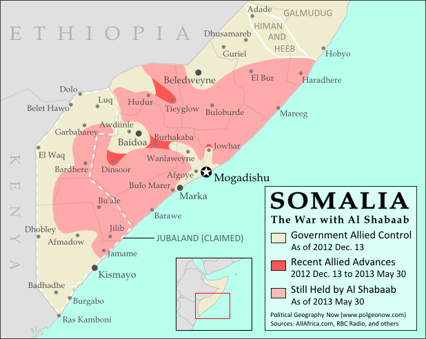 |
| Southern Somalia: recent government-allied advances in the war against Al Shabaab. Original map by Evan Centanni. Incorporates elements from this blank map by Eric Gaba and this locator map by TheEmirr. (license: CC BY-SA). |
Connecting Mogadishu and Baidoa
After news came in of the Somali Federal Government and its allies completing their control of southern Somalia's major cities last fall, further progress against the Al Qaeda affiliate group Al Shabaab at first made only slow progress. But since the beginning of this year, at least one major breakthrough has been made.
Thursday, May 23, 2013
Nigeria Conflict Map: Assault on Boko Haram
There are newer versions of this map available. To see them, view all Nigeria updates.
Nigeria's Boko Haram rebels have been active for some years, but it's only in recent months that they've become known to control territory in the country's far northeast. Now they're facing a full-on assault from the government after the president declared a state of emergency. Read on for details!
Nigeria's Boko Haram rebels have been active for some years, but it's only in recent months that they've become known to control territory in the country's far northeast. Now they're facing a full-on assault from the government after the president declared a state of emergency. Read on for details!
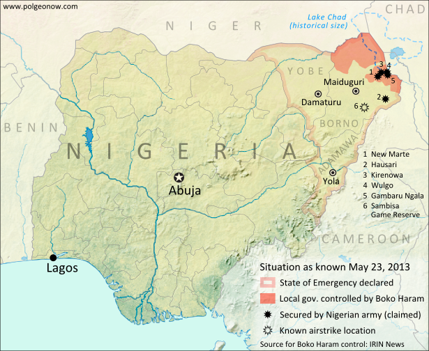 |
Boko Haram control and the government intervention in Nigeria's northeast. Map by Evan Centanni.
|
Friday, May 3, 2013
Mali Conflict Map: Hardline Rebels on the Run, Separatists Rebounding (May 2013)
There are newer versions of this map available. To see them, view all Mali maps.
This is an update within our Mali conflict map series - for the original story, see Mali Map: Islamist Control & French Intervention.
Towns Cleared of Islamist Rebels
Since our last Mali update in February, the country's religious extremist rebel groups have continued their retreat from the northern cities that they controlled for half a year. The military intervention by France and Mali's neighbors has somewhat reunited the country, though with some important exceptions.
This is an update within our Mali conflict map series - for the original story, see Mali Map: Islamist Control & French Intervention.
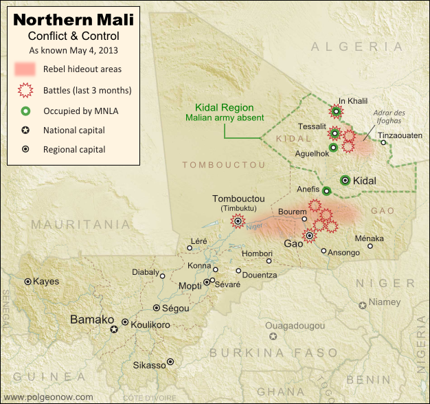 |
Updated map of territorial control and fighting in Mali, as of May 4, 2013. Map by Evan Centanni, modified from Wikimedia map by Orionist, using images by Carport and NordNordWest (source). License: CC BY-SA.
|
Since our last Mali update in February, the country's religious extremist rebel groups have continued their retreat from the northern cities that they controlled for half a year. The military intervention by France and Mali's neighbors has somewhat reunited the country, though with some important exceptions.
Thursday, April 25, 2013
Niger and Burkina Faso Resolve Territorial Dispute
Update: In May 2015, Niger and Burkina Faso formally agreed to implement this ICJ ruling, with the practical aspects of exchanging territories to be completed by the end of the following year.
By Evan Centanni
Border Dispute Settled
Last week, a territorial dispute between the West African countries of Niger and Burkina Faso was resolved peacefully with a ruling from the International Court of Justice (ICJ). Both countries' governments agreed to respect the court's ruling on where their border should lie, a question which had persisted ever since they both achieved independence in 1960.
In the ruling, the court drew an official border based on a careful analysis of a 1927 document establishing the pre-independence boundary between the two former French colonies, also turning to a 1960 French map which both countries had agreed to use as a secondary reference. The new border splits the disputed area between Burkina Faso and Niger, and will help put an end to confusion regarding policing and tax collection in the border area.
 |
| Map by Evan Centanni. Sources: ICJ, Natural Earth. Africa inset based on this map by TUBS/Wikimedia Commons (CC BY-SA). |
Border Dispute Settled
Last week, a territorial dispute between the West African countries of Niger and Burkina Faso was resolved peacefully with a ruling from the International Court of Justice (ICJ). Both countries' governments agreed to respect the court's ruling on where their border should lie, a question which had persisted ever since they both achieved independence in 1960.
In the ruling, the court drew an official border based on a careful analysis of a 1927 document establishing the pre-independence boundary between the two former French colonies, also turning to a 1960 French map which both countries had agreed to use as a secondary reference. The new border splits the disputed area between Burkina Faso and Niger, and will help put an end to confusion regarding policing and tax collection in the border area.
Friday, March 22, 2013
Central African Republic: Map of Rebel Advance to Capital (March 2013)
Last January, rebels in the Central African Republic agreed to a ceasefire with the government, after taking over much of the country. Now, despite the formation of a unity government, the ceasefire has broken down and the rebels are once again advancing on the capital and other towns. Read on for a summary of events. Update (March 24, 2013): The Séléka rebel coalition has now taken the national capital, Bangui.
Original Article: Central African Republic - Map of Rebel Control
Ceasefire Violations
After reaching a ceasefire with the government on January 11th, the Central African Republic's Séléka rebel coalition began integration into a new unity government, with several rebel leaders receiving prominent positions in President François Bozizé's cabinet. However, the violence did not end completely.
 |
Ceasefire Violations
After reaching a ceasefire with the government on January 11th, the Central African Republic's Séléka rebel coalition began integration into a new unity government, with several rebel leaders receiving prominent positions in President François Bozizé's cabinet. However, the violence did not end completely.
Tuesday, February 26, 2013
Libya Changes Official Name
 |
| Map of the last stage of Libya's 2011 civil war (click to see full map and original article). Map by Evan Centanni, based on public domain map from Wikipedia (source). |
Last month, the North African country of Libya changed its official long-form name to "State of Libya" (Arabic: Dawlat Libya). This comes as part of Libya's governmental transition following its 2011 civil war, in which a rebel coalition defeated the regime of dictator Muammar Gaddafi.
Over the last year, the country's formal name had not been clearly defined, with the country referred to in most documents simply as "Libya". The rebel National Transitional Council had only made a point of ceasing to use the Gaddafi-era name.
During the last decades of Gaddafi's reign, the country was known in long form as the "Great Socialist People's Libyan Arab Jamahiriya". The word "jamahiriya" was coined by Gaddafi by combining the Arabic words for "republic" (jumhuriya) and "the masses" (jamahir).
Subscribe to:
Posts (Atom)