Friday, December 28, 2012

Syria Uprising Map: December 2012 (#8)

There are newer versions of this map available. To see them, view all Syria updates.

 In recent months, Syria's rebels have continued to tip the balance of the country's civil war toward their favor, with various local victories and a few further extensions of their territorial control. Below is the updated conflict map, plus a summary of recent territorial changes.

Map of rebel activity and control in Syria's Civil War (Free Syrian Army, Kurdish groups, and others), updated for December 2012. Includes recent locations of conflict, including Salqin, Harem, Beer Ajam, Tishrin Dam, and Ras al-Ayn.
Activity and cities held by rebels and other groups in Syria, updated for December 2012. Map by Evan Centanni, starting from this blank map by German Wikipedia user NordNordWest. License: CC BY-SA

Thursday, December 20, 2012

Kosovo Now Recogized by Half of U.N. (97/193)

Map of countries that recognize the Republic of Kosovo as an independent state, updated for December 2012 with most recent additions highlighted
Countries recognizing the Republic of Kosovo in green, with the five most recent additions to the list labelled. Kosovo in magenta. Map by Evan Centanni, modified from public domain graphic (source).

Thursday, December 13, 2012

Somalia: Al Shabaab Map Update (Dec. 2012)

There are newer versions of this map available. To see them, view all Somalia articles on PolGeoNow.

Al Shabaab, Somalia's local branch of Al Qaeda, has continued to gradually lose territory since government-allied forces captured its main stronghold two months ago. As a follow-up to our October feature on the two-year retreat of Al Shabaab, we now present the latest changes to the map of control in southern Somalia.

Map of Al Shabaab control in southern Somalia as of December 2012, highlighting recent advances by government and African Union troops since the capture of key port city Kismayo. Includes the December capture of Jowhar by Ugandan AU forces.
Southern Somalia: recent government-allied advances against Al Shabaab. Original map by Evan Centanni. Incorporates elements from this blank map by Eric Gaba and this locator map by TheEmirr. (license: CC BY-SA).


Slow Progress Against Al Shabaab
Somalia's Islamic extremist militia, Al Shabaab, was greatly weakened when its biggest port and de facto capital of Kismayo was taken by government-allied African Union (AU) forces in October (See: The Retreat of Al Shabaab). However, it still controls a significant amount of territory, and the Somali and AU forces' advance has been slow, with their first major territorial gain acheived only this past weekend.

Thursday, December 6, 2012

Is Palestine Really a Country?

(Keep up with changes to Palestine's situation: view all Palestine updates.)

Palestine is now recognized as a country by both the U.N. and a majority of its members, but many  have questioned whether this new-found status reflects the truth on the ground. Is Palestine really an independent country, or is this a political fantasy concocted by supporters in the U.N.?

The Olso Accords divided the Palestinian territories into three areas of control (see article for explanation). Map by Evan Centanni. Sources: Natural Earth, B'Tselem, U.N. OCHA oPt.
What is a "sovereign state"?
By the most common definition, a "state" has to have:
  1. A government
  2. A defined territory
  3. A permanent population
  4. The ability to conduct foreign relations with other states
This definition is called the "declarative theory of statehood", and was formalized in the Montevideo Convention of 1933. To be a "sovereign" state (i.e. an independent country), it's also important that the government answers to no other country, and that the territory and population are actually under the government's control.

A prospective country that fits these criteria is described by geographers as a de facto sovereign state, even if it's not recognized by the international community (de facto is Latin for "in actual fact").

Friday, November 30, 2012

Palestine Recognized as a Country by the U.N.

(Keep up with changes to Palestine's situation: view all Palestine updates.)

This Thursday, the U.N. General Assembly voted to change Palestine's status in the organization from "observer" to "observer state". This is the first time the international body has recognized Palestine as a state, giving it the same status enjoyed by U.N. non-member Vatican City. 

Map of Israel with the occupied territories of the West Bank, Gaza Strip, and Golan Heights highlighted
The State of Palestine claims the West Bank and Gaza, which are largely occupied by Israel. The Golan Heights are not part of the Palestinian Territories. Public domain map (source).
Until this Thursday, Palestine was a partially recognized country, acknowledged by some U.N. member nations, but not by the U.N. itself (See also: How many countries are there in the world?). Although its delegation has had observer status at the U.N. since 1974, it was never classified as a "state", being treated as something between a country and a non-government organization. Now, the organization has officially voted to change Palestine's status to "observer state" - effectively a recognition that it's an independent country, even though it's still not a U.N. member.

The Palestinian delegation campaigned to join the U.N. as a member last year, but had to give up after the U.S. promised to veto the application in the U.N. Security Council. Observer status, on the other hand, is determined by a majority vote in the U.N. General Assembly, which no single country can veto. That vote happened on November 29th, with members voting 138 to 9 in favor of granting Palestine observer state status (41 members abstained, and 5 were absent from the vote; see the full breakdown of national votes).

Tuesday, November 27, 2012

Puerto Rico: 51st State of the U.S.?

[This article was written after Puerto Rico's 2012 status referendum. In June 2017, Puerto Rico voted in another controversial referendum, again technically in favor of statehood. Most of this five-year-old article is still accurate after the 2017 vote. -Editor]


Earlier this month, papers reported that Puerto Rico had voted to become a state of the U.S. - but will it really happen? What does it take to become a state, anyway? Last time, we explained Puerto Rico's current status - now for answers about the territory's future....

Flag of the United States with a new star added (total of 51 stars) for a hypothetical new state of Puerto Rico
A possible 51-star U.S. flag. Since each star on the flag represents one state, a new one would need to be added for Puerto Rico (public domain; source).
Why would Puerto Rico want to become a state?
Puerto Rico's current situation leaves it disadvantaged compared to the states. It has its own constitution and government, but the laws establishing them are subject to approval by the U.S. Congress. And despite the fact that most federal taxes and other laws apply to Puerto Ricans, residents have no real representation in Congress and no say in the presidential election. (For more details, see What is Puerto Rico?)

Friday, November 2, 2012

5 Countries You've Never Heard of (by Their Native Names)

Think you know your world geography? Maybe you know most or all of the world's countries...by their English names. But in their own official languages, many nation-states are called something completely different. Maybe you remember España, Deutschland, or Nippon from your high school language class - but there are a lot more than that! See if you can guess these five....

Misr
Also known in casual speech as Masr, this country is considered heir to the ancient kingdom of Kemet.  Locals trade in pounds, but drive on the right side of the road. As a country, Misr ranks 127th in GDP per capita, but boasts the world's 10th-largest active military. Bizarrely, its independence in 1922 was declared not by the nation's own people, but by another country. One of the world's oldest forms of Christianity is headquartered here, where it was founded by Saint Mark in the 1st century.


Tuesday, October 23, 2012

Syria Uprising Map: October 2012 (#7)

There are newer versions of this map available. To see them, view all Syria updates.

Syria's civil war has raged on over the last two months, with neither side gaining the upper hand. Death and destruction has been enormous, and territorial changes few, though not none. Read on for the rundown.

Map of rebel activity and control in Syria's Civil War (Free Syrian Army, Kurdish groups, and others), updated for October 2012
Activity and cities held by rebels and other groups in Syria, updated for October 2012. Map by Evan Centanni, starting from this blank map by German Wikipedia user NordNordWest. License: CC BY-SA

Thursday, October 18, 2012

Kosovo Recognized by Papua New Guinea (92/193)

Map of countries that recognize the Republic of Kosovo as independent, updated for Papua New Guinea's recognition in October 2012
Countries recognizing the Republic of Kosovo in green, with the most recent, Papua New Guinea (lower right), in lighter green. Kosovo in magenta. Map by Evan Centanni, modified from public domain graphic (source).

Tuesday, October 9, 2012

Somalia: The Retreat of Al Shabaab

There are newer versions of this map available. To see them, view all Somalia articles on PolGeoNow. 


One year ago, Kenya and Ethiopia invaded Somalia to end the rule of Al Shabaab, an Al Qaeda allied extremist group which had taken over the southern half of the country. This map and article are your guide to the militants' slow but steady retreat, culminating in last week's capture of the port city of Kismayo.

Map of the retreat of Al Shabaab Islamist militants in Somalia since 2011, culminating in the October 2012 capture of the key port city of Kismayo. Shows successive stages of advance by Kenyan, Ethiopian, and local forces.
The retreat of the Al Shabaab Islamist militant group in Somalia since 2011. Original map by Evan Centanni. Incorporates elements from this blank map by Eric Gaba and this locator map by TheEmirr. (license: CC BY-SA).

State of Anarchy
Located at the tip of East Africa's "Horn", Somalia has been wracked by chaos and violence since the fall of its last effective national government in 1991. While the northern Somaliland and Puntland regions formed autonomous governments, central and southern Somalia were ruled for many years by a patchwork of local warlords.

Friday, September 21, 2012

Yemen Conflict Map: September 2012 (#4)

Since June, the Yemeni government has completed its campaign to free the south from Al Qaeda rule, but multiple rebel movements remain active. Keep reading for a summary of the current situation. (To see other maps in this series, view all Yemen updates.)

Map of current division in Yemen, including Al Qaeda or Ansar al-Sharia activity, Houthi rebel control, and the location of the Southern Movement insurgency. Update for September 2012.
Presence of rebel forces in Yemen as of September 2012. Ansar al-Sharia is part of Al-Qaeda in the Arabian Peninsula (AQAP). Map by Evan Centanni, using this blank map by NordNordWest/Wikipedia (license: CC BY-SA).


Friday, September 14, 2012

Malawi's Flag Change

New and old flags of Malawi
Malawi's original rising-sun flag (left) is being re-adopted, after being controversially replaced two years ago by the full-sun banner (right). Graphics are in the public domain (left source; right source).
Just two years after adopting a new flag, the southeast African country of Malawi is changing back to the old one. The original banner, in place from independence in 1964 until its replacement in 2010, was voted back in by the national parliament on May 28, 2012.

Flag of Malawi Country Name:  
• Malawi (English)
• Malaŵi (Chichewa)
Official Name:  
• Republic of Malawi (English)
• Dziko la Malaŵi (Chichewa) 
Capital: Lilongwe
The independence flag, which displays a rising sun to represent the dawn of hope for Africa, was controversially replaced by President Bingu wa Mutharika two years ago. The colors were shuffled around to more closely match the Pan-African Flag, and the red rising sun was changed to a full white sun to symbolize the progress made by Malawi since independence.

When President Mutharika died last April, the Malawian government wasted little time in reverting the unpopular flag change. The move was supported by newly sworn-in President Joyce Banda, who had recently experienced a falling-out with Mutharika and started a new political party.

Although the flag change vote passed in parliament, it is still unclear whether it has passed officially into law via the required presidential signature. In any case though, the rising-sun flag appears to be widely in use again, being flown in the Olympics and displayed on many official websites (except for the main government homepage).

Thursday, September 6, 2012

Independent Azawad No More: Northern Mali in Islamist Hands

There are newer versions of this map available. To see them, view all Mali maps.   

Since declaring the independence of Azawad in April, control by northern Mali's MNLA rebels has been usurped by the hardline Islamists of Ansar Dine and MUJAO. The new regime, while still bitter enemies of the Malian government, does not claim independence. Presented here is a map and brief guide explaining the current situation.

Map of Islamist rebel control in northern Mali as of September 2012
Area held by Islamist rebel groups Ansar Dine and MUJWA in northern Mali. Map by Evan Centanni, modified from Wikimedia map by Orionist, using images by Carport and NordNordWest (source). License: CC BY-SA.
Separatists vs. Islamists
Last April, the Tuareg-dominated separatists of the National Movement for the Liberation of Azawad (MNLA) swept into victory in northern Mali, completing their control of the region and declaring independence as the State of Azawad. But their victory was won only with the support of Ansar Dine, an Islamist militia led by veteran Tuareg fighter Iyad Ag Ghaly. The MNLA and Ansar Dine then alternated between cooperation and conflict for months, with the Islamists grabbing ever more control of the region's cities.

Thursday, August 16, 2012

Syrian Uprising Map: August 2012 (#6)

There are newer versions of this map available. To see them, view all Syria updates.

Political Geography Now presents the sixth update to our map of rebel control in Syria's civil war. Since last month, battle has erupted in the country's largest city, Kurds have formed a parallel government in northern towns, and more. Read on for a rundown of recent events.

Map of rebel control in Syria's Civil War (Free Syrian Army, Kurdish groups, and others), updated for August 2012
Activity and cities held by rebels and Kurdish groups in Syria, updated August 16, 2012. Map by Evan Centanni, starting from this blank map by German Wikipedia user NordNordWest. License: CC BY-SA

Tuesday, July 31, 2012

Venezuela Joins Mercosur, Paraguay Suspended

Map of intergovernmental organizations in South America: Mercosur, the Andean Community, and UNASUR (Venezuela and Paraguy indicated)
South America's intergovernmental organizations: Mercosur in green, the Andean Community (CAN) in (orange), and remaining members of UNASUR in blue (claimed territorial extents). Map by Evan Centanni, based on this map by Wikimedia user Luan.
After over six years of waiting, Venezuela today officially joined Mercosur (the "Southern Common Market"), one of South America's two main trade blocs.

The country was previously part of the continent's other major bloc, the Andean Community (CAN), but left that organization last year in anticipation of the switch to Mercosur (see Venezuela Leaves Andean Community).

By the time the Venezuela left CAN last year, its application had finally been approved by all Mercosur member states except for Paraguay; but despite support from that country's president, an opposition party in its congress continued to block Venezuela's entry into the trade organization.

Thursday, July 26, 2012

London 2012: Which Countries Are (and Aren't) in the Olympics?

This is an older version of our Parade of Nations article. Click here to see the newest edition!

The 2012 Summer Olympics in London begin tomorrow (July 27), and it wouldn't be an Olympic opening ceremony without the Parade of Nations. But how many countries are there in the games, and is everyone included? Read on for an exclusive guide to the roster of Olympic Nations....

World map showing the five continental associations of National Olympic Committees, including all nations eligible for the Olympic games
The five continental associations representing the world's Olympic Nations. Gold: Pan-American Sports Organization; Green: European Olympic Committees; Black: Olympic Council of Asia; Red: Oceania National Olympic Committees; Blue: Association of National Olympic Committees of Africa; Gray: non-member country or territory. Map by Evan Centanni, modified from public domain wiki map (source), and modeled after this Wikipedia map.

Wednesday, July 11, 2012

Syrian Uprising: Map Update 5

There are newer versions of this map available. To see them, view all Syria updates.

Political Geography Now presents an updated map of territorial division in Syria, where escalating violence is now referred to by the U.N. as a full-scale civil war. Read on for a rundown of recent events.
Map of rebel control in Syria's Civil War, updated for July 2012
Activity by rebel groups in Syria, marking areas of armed conflict as well as towns and cities held. Map by Evan Centanni, starting from this blank map by German Wikipedia user NordNordWest. License: CC BY-SA

Thursday, June 21, 2012

Kosovo Recognized by Chad (Total: 91/193)

Map of countries that recognize the Republic of Kosovo as independent, updated for June 2012
Countries recognizing the Republic of Kosovo in green, with the most recent, Chad, in lighter green (click to enlarge). Kosovo in magenta. Map by Evan Centanni, modified from public domain wiki map (source).

Saturday, June 16, 2012

Yemen Conflict: Map Update 3

Fighting between Yemen's transitional government and Al Qaeda branch Ansar al-Sharia reached a climax this week, as government forces captured the militants' strongholds in Abyan province. This article gives a rundown of recent events and the current situation in divided Yemen.

Map of division in Yemen, including control by Al Qaeda or Ansar al-Sharia, the Houthi rebels, and the Southern Movement. Update for June 2012.
Presence of anti-government forces in Yemen in June 2012. Ansar al-Sharia is part of Al-Qaeda in the Arabian Peninsula (AQAP). Map by Evan Centanni, using this blank map by NordNordWest/Wikipedia (license: CC BY-SA).


Friday, June 1, 2012

Syrian Uprising: Update 4

There are newer versions of this map available. To see them, view all Syria updates.

Full Story: See Syria Divided by Armed Conflict

Map of Syria's uprising, marking cities and towns under control of the Free Syrian Army rebels as of June 2, 2012. Includes the site of the recent Houla massacre.
Known areas of armed activity for the rebel "Free Syrian Army" (click to enlarge). My own work, starting from this blank map by NordNordWest. License: CC BY-SA
Wondering what's been going on in Syria since our last map update? There have been few, if any, major changes in territorial control, but here's a brief status update. 

Despite the U.N. brokered ceasefire between the Syrian military and the rebel Free Syrian Army, which was to enter in effect on April 10, armed clashes have continued in many parts of the country, including recent heavy fighting in Rastan. Bloodshed reached a horrific peak a week ago, as over one hundred civilians - nearly half of them children - were massacred in the Houla area of Homs province. Witnesses told the U.N. that the murders were committed by militias loyal to President Assad, though the Syrian government attempted to blame the atrocity on the rebels. In the aftermath, one commander of the Free Syrian Army threatened to call off the ceasefire altogether, which could mean increased fighting in the coming weeks.

Country Name:  
• Syria (English)
• Sūriyya/Sūryā (Arabic)
Official Name:  
• Syrian Arab Republic (English)
• al-Jumhūriyyah al-‘Arabīyah  as-Sūriyyah (Arabic)
Capital: Damascus
Territorial control by the government and rebels has remained mostly the same since April. The only change made to the map is the addition of Houla in red, as at least one source indicates the area was under rebel control both before and after the massacre. Note that the Free Syrian Army is also reported to control much of the northwestern Idlib province outside of the main cities, though the situation is fluid and information is scarce, making it difficult to mark anything definitively on the map. 

Friday, May 25, 2012

Map: Sudan & South Sudan's Disputed Territories

Countries: South Sudan, Sudan
Official Names: Republic of South Sudan, Republic of Sudan
Summary: After South Sudan declared independence from Sudan last year, much of the border between the neighbors is still hotly disputed, with recent violent clashes around the Heglig oil field and other areas. Read on for a full list of Sudan and South Sudan's eight major border flashpoints.

Map of the border between Sudan and South Sudan, marking selected territorial disputes and border clashes in 2012. Includes inset map of April fighting in region of Heglig oil field.
Border map of Sudan and South Sudan, showing disputed areas and fighting since the beginning of 2012. Aerial bombings and attacks by rebel groups not shown. My own work, using blank Sudan and South Sudan maps by NordNordWest / Wikipedia. License: CC BY-SA.


Wednesday, May 2, 2012

Kosovo Recognition Update (Total: 90/193)

Country Name: Kosovo (English, Serbian), Kosova (Albanian)
Official Name: Republic of Kosovo (English), Republika e Kosovës (Albanian),
Republika Kosovo (Serbian)
News Categories: Recognition, Partially Recognized States, Breakaway States
Full Story: See Kosovo Diplomatic Recognition Continues

Map of countries that recognize the Republic of Kosovo as independent
Countries recognizing the Republic of Kosovo in green, with arrows marking the two most recent: São Tomé and Príncipe (left) and Brunei (right). Kosovo in magenta. Modified from public domain wiki map (source).

Tuesday, April 10, 2012

Syrian Uprising: Map Update 3

There are newer versions of this map available. To see them, view all Syria updates.

Country Name: Syria (English), Sūriyya/Sūryā (Arabic)
Official Name: Syrian Arab Republic (English),
al-Jumhūriyyah al-‘Arabīyah as-Sūriyyah (Arabic)
News Category: Divided Countries
Full Story: See Syria Divided by Armed Conflict

Map of Syria, showing control by the rebel Free Syrian Army as of April 10, 2012
Known areas of armed activity for the rebel "Free Syrian Army", marking controlled cities and notable towns.
Many rural areas may also be under full rebel control. Unarmed protests not shown. Map is my own work,
starting from this blank map by German Wikipedia user NordNordWest. License: CC BY-SA

Friday, April 6, 2012

Declaration of Independence of Azawad (English Translation)

Country Name: Azawad (English, Tuareg, French), Azawād (Arabic)
News Categories: New Countries, Breakaway States, Unrecognized States
Full Story: New Country: Azawad Declares Independence from Mali

Flag of Azawad (image by Orionist; source)
Presented here is the full text of the Declaration of Independence of Azawad, originally posted in French to the website of the National Movement for the Liberation of Azawad (MNLA) on April 6, 2012, and translated into English by Evan Centanni of Political Geography Now. The MNLA is a Tuareg-led rebel group which has recently achieved control of the northern part of Mali in West Africa. For a history of the 2012 Tuareg rebellion in Mali, view all Mali posts on Political Geography Now.

New Country: Azawad Declares Independence From Mali

Country Name: Azawad (English, Tuareg, French), Azawād (Arabic)
News Categories: New Countries, Breakaway States, Unrecognized States
Summary: Tuareg-led rebels in northern Mali have declared "the independent state of Azawad", after taking control of all of the region's major cities and military bases and advancing to near the edge of their claimed territory. Azawad is not recognized as an independent country by any U.N. members, making it an example of a so-called "breakaway state".

Map of the new independent state of Azawad, declared by MNLA Tuareg rebels in northern Mali. Shows claimed territory and towns controlled by the rebels group as of April 6, 2012
Map of State of Azawad, declared by the Tuareg-majority MNLA rebel group in Mali. Modified from Wikimedia map by Orionist, incorporating images by Carport and NordNordWest (source). License: CC BY-SA.
See Also: Mali Divided by Separatist Fighting; all Mali map updates

MNLA Claims Independent Azawad
The National Movement for the Liberation of Azawad (MNLA) today declared independence from Mali via a statement in French on its website. The rebels of the MNLA, mostly from the Tuareg ethnic group of the Sahara Desert, claim that the northern region of Mali, which they call Azawad, was wrongly included in that country when it declared its independence from France in 1960. There has not yet been any announcement on what form of government Azawad will have, or on which city will be its capital, but the MNLA says it is committed to democracy, to following the rules of the U.N., and to respecting the borders of other countries in the region.

Full Text: Declaration of Independence of Azawad (English Translation)

Flag of the independent state of Azawad, as claimed by the MNLA Tuareg rebel group in northern Mali
Flag of Azawad (image by Orionist; source)
The breakaway state of Azawad is not yet recognized diplomatically by any of the world's other countries, and is unlikely to be any time soon. It joins the ranks of the various wholly or partially unrecognized states of the world, including fellow African state Somaliland, which similarly controls its whole territory despite complete lack of recognition from either the U.N. or other states. This status will likely prevent Azawad from appearing on mainstream world maps for some time to come.

Map showing the location of the new state of Azawad in Africa, declared by the MNLA Tuareg rebel group in northern Mali
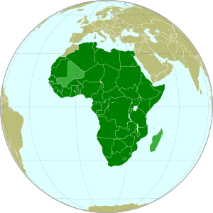
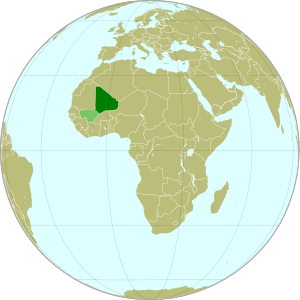
Azawad (dark green) and remainder of Mali (light green) in
Africa. Modified from this Wikimedia map (public domain).
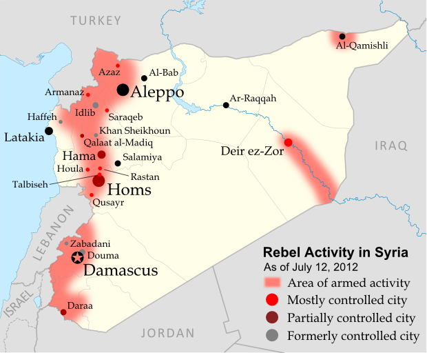
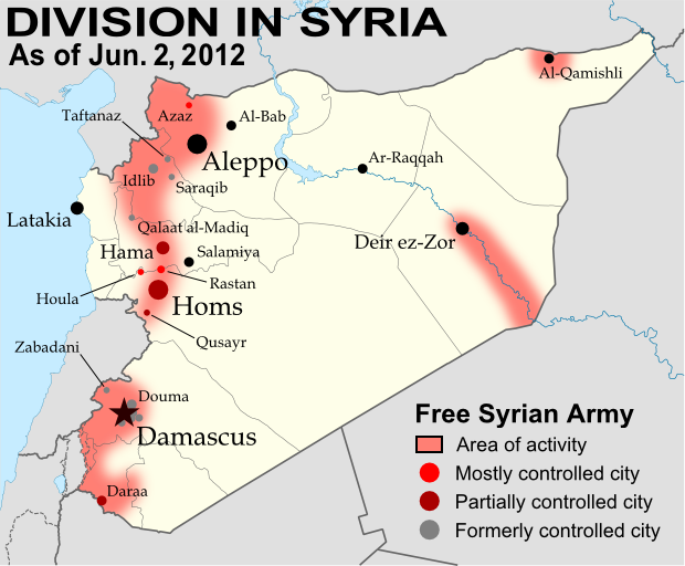
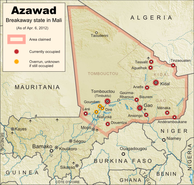
Update on Territorial Control
Since our last map update, the Tuareg rebels of the MNLA advanced as far as the town of Douentza (according to their own claims, which have not been disputed), after which they declared a ceasefire, saying they had completed their mission to liberate Azawad. The town of Niafunké has also apparently switched hands a few times over the last few months (source in French), with its current situation unclear. The reality is that the Malian military probably no longer controls anything within the claimed territory of Azawad. Towns not shown as rebel-controlled on the map may simply not be occupied by anyone.

However, the new state of Azawad now faces a threat from another direction - the Islamist Ansar Dine militia, which fought alongside the MNLA over the last few months (with or without their approval). Ansar Dine is now attempting to install strict Sharia (Islamic law) in the cities, in opposition to the MNLA's claimed desire for a secular state. An additional complication is that Ansar Dine in fact does not support independence for Azawad, believing instead that Sharia law should be instated throughout Mali. Ansar Dine is also a Tuareg-led group.

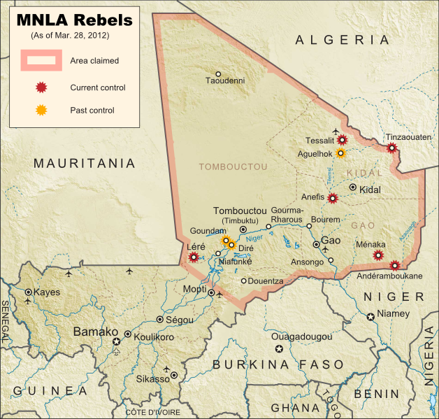
Seen this Mali conflict map on Wikipedia?
While Political Geography Now sometimes uses free maps from Wikipedia or other sites (after double-checking their sources), we also occasionally post our own maps to Wikipedia and Wikimedia Commons for others to use. The first version of this particular map of the Tuareg-led rebellion in Mali was created for Wikipedia by Orionist, but I have since taken charge of keeping it updated, with a bit of help from Mnmazur on Wikimedia Commons (Mnmazur is not associated with Political Geography Now).

Sunday, April 1, 2012

Mali Conflict Map: Separatists Capture Timbuktu and Gao (April 2012)

Country Name: Mali (English, French, Bambara)
Official Name: Republic of Mali (English), République du Mali (French)
News Category: Divided Countries
Summary: Tuareg-led rebels in northern Mali have now completed their control of the region's major cities, after capturing the military headquarters in Gao as well as historic Timbuktu. Meanwhile, Mali has been suspended from regional organization ECOWAS in response to the recent coup d'etat in the capital, Bamako.

Map of Tuareg rebellion in Northern Mali (Azawad), showing towns controlled by the MNLA rebel group as of April 1, 2012
Towns captured by the Tuareg-majority MNLA rebel group in Mali. Modified from Wikimedia map by Orionist, incorporating images by Carport and NordNordWest (source). License: CC BY-SA.
Full Story: Mali Divided by Separatist Fighting; all Mali map updates

Conflict Update
Again immediately following our last update, northern Mali's National Movement for the Liberation of Azawad (MNLA), made up mostly of Saharan Tuareg people, has followed its victory in Kidal by capturing the region's other two major cities. On March 31, the rebels took control of Gao, headquarters of the Malian military in the north, and the next day overran Timbuktu, a historic former trading post and modern tourism destination. The town of Aguelhok in the north is now also being reported as under Tuareg control, though it is unclear when it was recaptured (the rebels had previously taken and lost it again back in January).

The military government of Mali, which took over in a recent coup d'etat, has now withdrawn its forces from most of northern region, known to the Tuareg rebels as Azawad. Neighboring countries have offered military assistance only if the country returns to democracy, and have suspended Mali's membership in the Economic Community of West African States (ECOWAS) while imposing tough sanctions. If help doesn't come soon, the MNLA could be in the position to declare independence in the north, making Azawad Africa's newest country.

Follow events as they develop on Political Geography Now! To see only stories about this ongoing conflict, filter posts using the Mali label.

Seen this map on Wikipedia?
While Political Geography Now sometimes uses free maps from Wikipedia or other sites (after double-checking their sources), we also occasionally post our own maps to Wikipedia and Wikimedia Commons for others to use. The first version of this particular map of the Tuareg-led rebellion in Mali was created for Wikipedia by Orionist, but I have since taken charge of keeping it updated, with a bit of help from Mnmazur on Wikimedia Commons (Mnmazur is not associated with Political Geography Now).

Saturday, March 31, 2012

Mali Conflict Map: Separatists Capture Kidal (March 2012)

Country Name: Mali (English, French, Bambara)
Official Name: Republic of Mali (English), République du Mali (French)
News Category: Divided Countries
Summary: Tuareg-led rebels in northern Mali have taken the important city of Kidal, as well as two other towns, and are now advancing on Gao, the northern headquarters of the Malian military.

Map of Tuareg rebellion in Northern Mali, showing towns controlled by the MNLA rebel group as of March 31, 2012
Towns captured by the Tuareg-majority MNLA rebel group in Mali. Modified from Wikimedia map by Orionist, incorporating images by Carport and NordNordWest (source). License: CC BY-SA.
Full Story: Mali Divided by Separatist Fighting

Conflict Update
Right on the heels of our last Mali map update, the Tuareg-led rebels of the National Movement for the Liberation of Azawad (MNLA) have made a great deal of further progress, including their biggest victory yet. Yesterday the rebel group captured Kidal, one of the three main cities in northern Mali (the region in which they hope to establish an independent country called Azawad). This time, it was widely reported that the MNLA was working together with Ansar Edine (or "Ansar Dine"), an Islamist group also led by a veteran Tuareg fighter, but which the other rebels had formerly shunned.

Just after overrunning Kidal, the MNLA was reported to have taken the towns of Bourem and Ansongo on either side of Gao, a key city containing the northern headquarters of the Malian military. Malian troops had previously announced their withdrawal from those two towns in order to focus their defense on the city. Now, the Tuareg fighters have entered the city of Gao, and are currently fighting to take the two military bases there. Follow events as they develop on Political Geography Now! To see only stories about this ongoing conflict, use the Mali filter.

Wednesday, March 28, 2012

Mali Conflict Map: Separatists Gain Ground in North (March 2012)

Country Name: Mali (English, French, Bambara)
Official Name: Republic of Mali (English), République du Mali (French)
News Category: Divided Countries
Summary: The rebellion of Tuaregs and other ethnic groups in northern Mali has continued gaining territory, and now threatens major cities in the north, where the rebels seek to establish an independent country called Azawad. Meanwhile, Malian military leaders upset with their government's handling of the rebellion have taken over the country in a coup, leading to increased chaos on the country's suspension from the African Union.

Map of Tuareg rebellion in Northern Mali, showing towns controlled by the MNLA rebel group
Towns captured by the Tuareg-majority MNLA rebel group in Mali. Modified from Wikimedia map by Orionist, incorporating images by Carport and NordNordWest (source). License: CC BY-SA.
Full Story: Mali Divided by Separatist Fighting

Conflict Update
After a month with no territorial gains or losses reported, on March 11 the National Movement for the Liberation of Azawad (MNLA) captured of the town of Tessalit in Mali's far north. Home to a major military base and an airport, Tessalit was a major prize for the rebels, most of whom come from the traditionally nomadic Tuareg ethnic group. Their push for independence continued two days later with the storming of Diré and Goundam, two towns near the major northern city of Timbuktu, though it is unclear whether those two towns are still occupied by the MNLA.

Map of the African Union, marking suspended members Mali and Madagascar
The African Union (green) with suspended members
Mali and Madagascar in lighter green. Modified from
this Wikimedia map (public domain).
An unexpected turn of events came on March 21, when the Malian government fell in a military coup. The leaders of the takeover cited President Amadou Toumani Toure's ineffectiveness at combating the Tuareg revolt in the north as their reason; ironically however, the chaos caused by the coup has proved beneficial to the rebels, who on March 23 captured the town of Anefis on the road between Gao and Kidal, two of the north's major cities. The MNLA has boasted that it will soon take those two cities, as well as Timbuktu, and recently it has indeed been reported that Malian troops in Kidal are negotiating a surrender after the city was surrounded by Tuareg militias.

In the confusion, another Tuareg-led rebel group, the Islamist Ancar Dine, has also claimed to control the towns of Tinzaouaten, Tessalit, and Aguelhok, which according to most other sources are actually held by the MNLA. Though the two rebel groups have a share a history of being formed by leaders of former Tuareg rebellions, some local experts doubt that they are actually working together. Meanwhile, the coup in Mali's capital city of Bamako has resulted in the country's suspension from the African Union (AU), an important regional organization which includes every country in Africa except for Morocco. Mali is one of only two currently suspended AU states, the other being Magascar, which also experienced a coup d'etat several years ago.

(Note: For updates to the Mali conflict map, follow the Mali label on Political Geography Now.)

Tuesday, March 20, 2012

Syrian Uprising: Map Update 2

There are newer versions of this map available. To see them, view all Syria updates.

Country Name: Syria (English), Sūriyya/Sūryā (Arabic)
Official Name: Syrian Arab Republic (English),
al-Jumhūriyyah al-‘Arabīyah as-Sūriyyah (Arabic)
News Category: Divided Countries
Full Story: See Syria Divided by Armed Conflict

Map of Syria, showing control by the rebel Free Syrian Army as of March 20, 2012
Known areas of armed activity for the rebel "Free Syrian Army" - many rural areas may be under full rebel
control. Unarmed protests not shown. Revised for control of Qalaat al-Madiq and Azaz (see article). Map
is my own work, starting from this blank map by German Wikipedia user NordNordWest. License: CC BY-SA
(Note: For further updates to this map, follow the Syria label on Political Geography Now.)

Syria Conflict Update
The last few weeks have seen territorial losses for the Free Syrian Army (FSA), as government forces have executed a series major offensives on rebel-held areas. By the end of February, Qusayr near Homs was already reportedly only under partial control of the FSA, and on March 1 the Syrian army overran the rebel stronghold district of Baba Amr in the city of Homs itself. While fighting continues in a few other districts, the capture of Baba Amr was widely seen as crucial defeat for the FSA in Homs.

Less than two weeks later, government forces successfully took the northern city of Idlib from the rebels after a three-day battle. Daraa in the south and Deir ez-Zor in the east have also seen government offensives, while shelling continues in Rastan and rebel-held areas of Hama, though territorial control of these areas has mostly not changed. Meanwhile, since our last update, significant FSA activity has been reported for apparently the first time in the areas around Aleppo and Al-Qamishli, both cities that have been relatively quiet up until now.

This map also contains a correction from the last report - the town of Zabadani near Damascus was held by the rebels through late January and early February, but was taken back by the Syrian army prior to the last map update on February 26. That map has now been updated as well. Finally, the meaning of red coloration for cities on the map has been adjusted to include cities mostly under rebel control, since it is often difficult to determine whether control is 100% complete. You can see Political Geography Now's original report and background information on the Syrian uprising in the article entitled Syria Divided by Armed Conflict.

Revision (April 10, 2012)
Since this map was first posted, it has since been reported that Azaz and Qalaat al-Madiq were already under rebel control on March 20. The map has been revised to show this.

Useful Link: Wikipedia - Timeline of the 2011-2012 Syrian Uprising

Thursday, March 15, 2012

Kosovo Diplomatic Recognition Continues

Country Name: Kosovo (English, Serbian), Kosova (Albanian)
Official Name: Republic of Kosovo (English), Republika e Kosovës (Albanian),
Republika Kosovo (Serbian)
News Categories: Recognition, Partially Recognized States, Breakaway States
Summary: The Republic of Kosovo has continued to receive diplomatic recognition from other countries, despite widespread opposition to its 2008 declaration of independence from Serbia. Thirteen more U.N. members have declared their recognition of independent Kosovo just within the last year.

Flag of the Republic of Kosovo
Flag of the Republic of Kosovo.
Image by Cradel (source). License: CC BY-SA
Full Story
The majority of recently independent countries, such as South Sudan and Montenegro, enjoy unopposed recognition from the U.N. and its members. However, acceptance into the international community doesn't always come so easily. Kosovo is one example: because it declared its independence without first coming to an agreement with its former host country (unlike South Sudan and Montenegro), it has struggled to gain acceptance as a sovereign state. The last of the Balkan countries to declare independence after the breakup of Yugoslavia in the 1990s, Kosovo was first separated unofficially from the country in 1999, when NATO intervened militarily in the province to stop Serbian government violence against ethnic Albanians. The Albanians are a cultural group from southeastern Europe who speak a unique language only distantly related to other European tongues, and like the Bosniaks in nearby Bosnia & Herzegovia, are one of the few majority-Muslim European peoples. They also form a majority of the population in the neighboring country of Albania.

Map of Kosovo within Serbia
Kosovo, claimed as a province of Serbia, is
policed by U.N. and E.U. peacekeepers. The
Republic of Kosovo also governs the region,
except for the Serbian-loyalist north. Map is
my own work, based on these two blank
maps by Nord-NordWest. License: CC BY-SA
Policed by a U.N. peacekeeping mission since 1999, most of Kosovo has never since been controlled by the Yugoslav (now Serbian) government, though the U.N. still officially considers it to be a province of Serbia. Despite fierce political opposition from Serbia, Russia, and other countries, as well as from the ethnic Serb minority within Kosovo, the local government declared independence in 2008. The self-proclaimed Republic of Kosovo government has since administered the territory alongside the U.N. and another police force sent by the European Union, though the Northern Kosovo area, a Serb-majority region, has resisted independence and continues to support the Serbian government in Belgrade, even setting up roadblocks to keep out the Kosovan police - a sort of breakaway state within a breakaway state.

The Republic of Kosovo has not been admitted into the U.N., and it is recognized by only 88 U.N. member countries (many of them NATO members or countries with Muslim populations) and one other state (Taiwan). Serbia and Russia still strongly oppose independence for Kosovo, but the list of states recognizing its sovereignty has nevertheless continued to grow. Within the last year, 13 more U.N. members have offered diplomatic recognition of Kosovan independence: Andorra, the Central African Republic, Guinea, Niger, Benin, Saint Lucia, Nigeria, Gabon, Ivory Coast, Kuwait, Uganda, Ghana, and Haiti.

Map of countries recognizing the Republic of Kosovo
Diplomatic recognition of the Republic of Kosovo. Countries that recognized Kosovan independence recently (in the last twelve months) in light green, others in dark green; Kosovo in magenta. Public domain (source).
Sources: See citations on Wikipedia's list of Entities that recognize Kosovo as an independent state.

Sunday, March 11, 2012

Map Update: Yemen Conflict

Country Name: Yemen (English), Al Yaman (Arabic)
Official Name: Republic of Yemen (English), Al Jumhūriyyah al Yamaniyyah (Arabic)
News Category: Divided Countries
Summary: Despite a negotiated end to its political crisis, Yemen is still deeply divided between the official government and at least three separate armed groups which existed even before the recent turmoil. For a description of the beginnings of Yemen's popular uprising and the first version of this conflict map from last July, see Yemen Fragments Under Uprising. A previous updated version of that map can be seen in the News Bits: October 2011 article.

Major areas of non-government control in Yemen, held by armed groups resistant to the country's recent power-sharing deal. Ansar al-Sharia and Al-Qaeda in the Arabian Peninsula (AQAP) are two related Islamic extremist groups. Map is my own work, from this blank map by Wikipedia user NordNordWest (license: CC BY-SA)


(Note: For updates to this map, follow the Yemen label on Political Geography Now.)

Conflict Update
Since last fall, the conflict in Yemen has undergone something of a change in direction. In November President Ali Abdullah Saleh finally signed an agreement with the Joint Meeting Parties, a coalition of opposition politicians that includes Nobel Peace Prize winner Tawakkul Karman. Under the deal, brokered by the Gulf Cooperation Council, Saleh would yield the presidency in February to vice president Abd Rabbuh Mansur Al-Hadi via a symbolic election. After the power transfer went forward as planned last month, opposition militias have mostly ended their conflicts with the government, and unarmed protests have decreased (but not ended altogether). The city of Taiz, referred to as the heart of Yemen's revolution, has been largely demilitarized, and the streets of Sana'a no longer see frequent violence.

Useful Link: Timeline of the 2011–2012 Yemeni uprising (Wikipedia)

However, not all groups have fully agreed to the terms of the new arrangement. Most notably, there are three major armed groups who have been resisting the Yemeni government since long before last year's popular uprising began:

Ansar al-Sharia & Al Qaeda in the Arabian Peninsula (AQAP): These two apparently connected groups of Islamic extremists took advantage of the chaos of the revolution to carve out their own territories in southern Yemen. Ansar al-Sharia now controls much of Abyan and Shabwah provinces, including hotly contested Zinjibar, as well as its recently declared "Islamic emirates" in both Jaar (which they renamed Waqar) and the eastern Shabwah region. Al Qaeda affiliate AQAP operates widely in the country, and in January briefly captured the town of Rada'a before withdrawing after negotiations with local leaders. Ansar al-Sharia and AQAP have played no part in the peace process, and are sworn enemies of nearly all other major political groups in the country.

The Al Houthi Rebels: The Houthis are a Shiite insurgent group that has fought several wars for autonomy from predominantly Sunni Yemen since 2004. During the beginnings of last year's uprising, the Houthis solidified control over their home region of Sa'dah in the far northwest of the country, and have recently extended their power to the three surrounding provinces as well. The group's leadership has called for participation in the national reconciliation process, but boycotted voting in last month's single-party election. Only time can tell whether the Houthis' territories will be integrated into Yemen or again erupt into full-blown rebellion.

The Southern Separatists: Ever since North and South Yemen united in 1990, southerners wishing to re-secede have become a major political force in the country. Many of the separatists use peaceful political methods, but there are also insurgents who occasionally make attacks on the government in the name of southern independence. These separatist militants played only a small part in the uprising last year, but have recently become more active, denouncing last month's election and even going so far as to attack polling stations. Though they do not solidly control any territory, they still form a major threat to unity in Yemen.

Further Reading: Land of the Black Flag - Journalist Casey Coombs visits and photographs the Ansar al-Sharia stronghold of Jaar, the so-called "Islamic Emirate of Waqar".

Major Sources:
Yemen Post News
AEI Critical Threats