Thursday, January 11, 2018

How Many Countries Are There in the World in 2018?

There are newer editions of this article available. To find the most recent, view all "How Many Countries in the World" updates!

How many countries: map of the world
A world political map published by the US government. South Sudan is the most recent addition to the UN-based list of the world's countries.
One of the most basic questions for map-lovers is, "How many countries are there in the world?" But anyone who just gives you a number isn't telling the whole truth. It actually depends a lot on how you define a "country".

Here are six of the most common answers, each correct in its own way:

Sunday, January 7, 2018

Yemen Control Map & Report - January 2018

There are newer versions of this map available. To see them, view all Yemen articles on PolGeoNow. 

This is the first edition of our newly-redesigned Yemen control map, which has been optimized to match our maps of control in Syria, Iraq, Libya, and Somalia.

Map of what is happening in Yemen as of January 6, 2018, including territorial control for the unrecognized Houthi government and former president Saleh's forces, president-in-exile Hadi and his allies in the Saudi-led coalition and Southern Movement, Al Qaeda in the Arabian Peninsula (AQAP), and the so-called Islamic State (ISIS/ISIL). Includes recent locations of fighting, including Mudiyah, Khoukha, Hays, Khab Al Sha'af, and more. Colorblind accessible.
Map by Evan Centanni and Djordje Djukic, from base map by Koen Adams of onestopmap.com. All rights reserved.
(Subscribers click here to view this article in the member area)

Timeline by Djordje Djukic, with additional reporting by Evan Centanni

Yemen: Who Controls What?
As we enter 2018, Yemen continues to be divided between two rival governments - the Saudi-backed administration of President Abdrabbuh Mansour Hadi, and the allegedly Iran-backed "Houthi" group that controls the capital - even while remote areas remain within the sphere of Al Qaeda in the Arabian Peninsula (AQAP). The so-called "Islamic State" (IS; formerly ISIS/ISIL) is not believed to control any towns, but is probably still present in the rural border areas between Bayda and Abyan provinces, near Lawdar.

Friday, December 22, 2017

Mauritania Flies a New Flag

Mauritania Flag: 2017 new flag design after referendum, featuring red bands
Current flag of Mauritania (2017)

Mauritania Flag: Colors before 2017 referendum that added red bands
Previous flag of Mauritania (1959-2017)

Mauritania's 2017 Flag Change

This year the West African country of Mauritania (pronounced "maur-ih-TAY-nee-ah") became the latest of the world's countries to change its flag, mostly keeping the old design but adding red bars on the top and bottom.

It's common around the world for even a small flag change to be criticized as a political distraction or a waste of money, and this was no exception. But when it landed on ballots in an August 5 referendum this summer, the modification was approved by 86% of participating voters.

The new flag was first officially raised on November 28, Mauritania's independence day.

What Does Mauritania's Flag Mean?

Until this year, Mauritania was one of only a few world countries whose flag didn't include the colors red, white, or blue. The star and crescent moon, originally an emblem of the Ottoman Empire, are now used in many national flags as symbol of the Muslim world.

Thursday, December 14, 2017

Syrian Civil War Map & Timeline: "Islamic State" Territory in Pieces - December 2017 (Subscription)

SUBSCRIBERS CLICK HERE TO PROCEED TO ARTICLE AND MAP

There are newer versions of this map available. To see them, view all Syria updates.

Research by Djordje Djukic. Map by onestopmap.com, Evan Centanni, and Djordje Djukic

Subscribe for full access to all conflict map reports!

Map of Syrian Civil War (Syria control map): Fighting and territorial control in Syria in December 2017 (Free Syrian Army rebels, Kurdish YPG, Syrian Democratic Forces (SDF), Jabhat Fateh al-Sham / Hayat Tahrir al-Sham (Al-Nusra Front), Islamic State (ISIS/ISIL), and others). Includes Russia-Turkey-Iran agreed de-escalation zones and US deconfliction zone, plus recent locations of conflict and territorial control changes, such as Abu Kamal, Quriyah, Rahjan, and more. Colorblind accessible.
As opposing forces close in, the so-called "Islamic State" (ISIS/ISIL) has seen its Syrian territory divided into seven different pieces, and you might be surprised where some of them are located. Meanwhile, fighting between the government and rebels continues at a low level.

See all this and more on the latest update to PolGeoNow's concise, professional Syrian Civil War control map, which includes a timeline of changes since our previous Syria map report in November, with sources cited.

This map and report are premium content, available to paid subscribers of the PolGeoNow Conflict Mapping Service.

Want to see before you subscribe? Check out our most recent FREE SAMPLE Syria map!

Exclusive map report includes:
  • Up-to-date illustration of current territorial control in Syria, color-coded for the Assad government, rebel groups, "Islamic State" (ISIS/ISIL) fighters, and Kurdish/SDF forces. Colorblind accessible.
  • Markers showing the approximate locations of Russian-Turkish-Iranian "de-escalation zones" and the one known US "deconfliction zone".
  • Special symbols indicating towns dominated by rebels of the former Al Qaeda Nusra Front (now Hayat Tahrir al-Sham) and US-backed Syrian Democratic Forces (SDF).
  • Detailed indication of city-by-city control, including key towns and other locations important to current events.
  • Locations of recent fighting and other important events, including Abu Kamal (Al Bukamal), Quriyah, Rahjan and more.
  • Detailed timeline of important events and changes to territorial control since November 14, 2017, compiled by our Syria-Iraq expert, with links to sources.

SUBSCRIBERS CLICK HERE TO PROCEED TO ARTICLE AND MAP

Not signed up yet? Click here to learn more about our professional subscription service!

Can I purchase just this map?
This map and report are not available for automated purchase to non-subscribers. If you need access or republication rights for only this map report, contact service@polgeonow.com for options.

Saturday, December 9, 2017

Explainer: Is Jerusalem the Capital of Israel or Not?

Detailed map of administrative control in Israel and the Palestinian territories (West Bank and Gaza Strip), including official and de facto capitals. Cities: Jerusalem, Ramallah, Gaza, Tel Aviv. Colorblind accessible.
Map by Evan Centanni. All rights reserved.

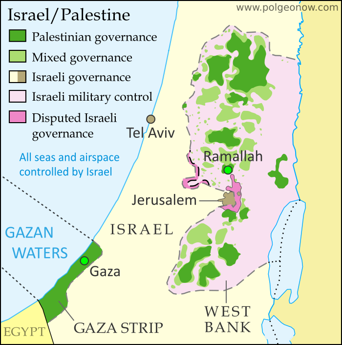
US recognizes Jerusalem as capital of Israel

This Wednesday, the United States government announced a new policy of recognizing Jerusalem as the capital of Israel. US president Donald Trump said the declaration's purpose was to "acknowledge the obvious", while also revealing plans to eventually move the US embassy in Israel to Jerusalem. These decisions were extremely controversial, to say the least. But why? We'll break it down for you:

What's the big deal?

Israeli law says the city of Jerusalem is the country's capital. But even Israel's closest ally, the US, has never officially accepted the city's capital status. And the world's countries generally haven't either: In fact, no country in the world has a proper embassy in Jerusalem. So the new move by the US is a major change of policy, and one that runs contrary to an established world consensus.