Updates on the world's countries and borders
Friday, October 13, 2017
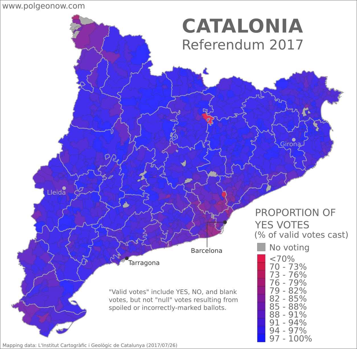
Catalonia Referendum: Detailed Results in 5 Maps
This map report is part of our Referendum 2017 coverage, spotlighting controversial independence votes in two of the world's autonomous regions: Kurdistan voted for independence from Iraq last month, and Catalonia tried to vote on leaving Spain on Oct. 1. Now we've mapped out Catalonia's results in detail based on data from the regional government.
Saturday, October 7, 2017
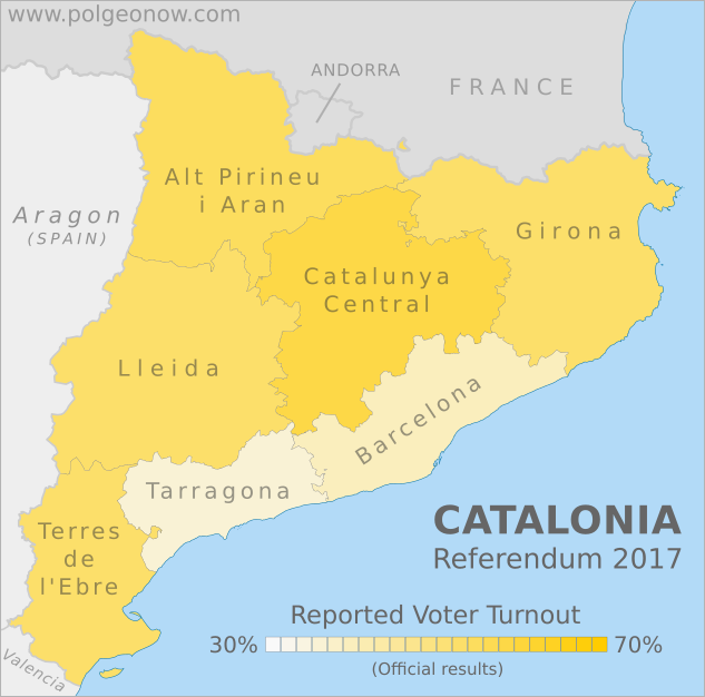
Updated! Catalonia Referendum Results Maps: How Did Each Region Vote?
Updated! This article's maps and text have been updated with final results released by the Catalan government. See below for more details. We also now have an article with detailed results maps broken down by municipality.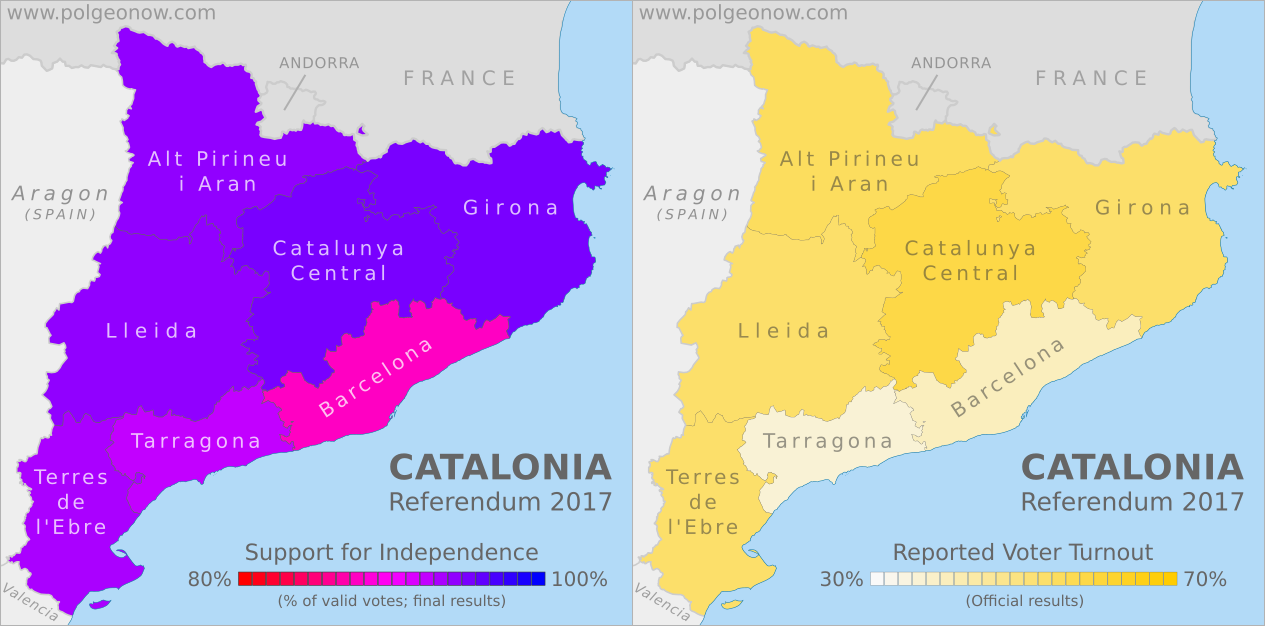
This map report is part of our Referendum 2017 coverage, spotlighting controversial independence votes in two of the world's autonomous regions: Kurdistan voted for independence from Iraq last week, and Catalonia voted to leave Spain this weekend. Now detailed results are available, and we're working on getting them mapped out.
This map report is part of our Referendum 2017 coverage, spotlighting controversial independence votes in two of the world's autonomous regions: Kurdistan voted for independence from Iraq last week, and Catalonia voted to leave Spain this weekend. Now detailed results are available, and we're working on getting them mapped out.
 |
 |
| Maps by Evan Centanni, starting from blank map by Vinals and Rwxrwxrwx. License: CC BY-SA | |
Catalonia Independence Vote (Updated)
Detailed, final results are now available for Catalonia's controversial referendum on independence from Spain. The vote was widely disrupted by the Spanish police after courts ruled it illegal, resulting in massive irregularities that will make it hard for outsiders to accept as a proper democratic referendum. Still, some 43% of eligible Catalan voters reportedly made it out to cast ballots, meaning there's plenty of reported data to look at.Saturday, September 30, 2017
Catalonia Voting on Independence: What Will Happen?
This article is part of our Referendum 2017 coverage, spotlighting controversial independence votes in two of the world's autonomous regions: Kurdistan voted for independence from Iraq this Monday, and Catalonia is about to vote on leaving Spain.
Update: Check out the bottom of the article for a brief summary of what's actually happened since referendum day!
By Evan Centanni
Update: Check out the bottom of the article for a brief summary of what's actually happened since referendum day!
 |
| Map by Evan Centanni, based on this map by Mutxamel. License: CC BY-SA |
Catalonia Independence Vote
Catalonia, a self-governed region within Spain, is about to start voting on independence in a referendum that Spanish courts have ruled illegal. So what will happen? No one really knows, but we've taken our best shot at answering six of the big questions...Referendum 2017: What is Catalonia?
This article is part of our Referendum 2017
coverage, spotlighting controversial independence votes in two of the
world's autonomous regions: Kurdistan voted for independence from Iraq this Monday, and Catalonia will vote Sunday on leaving Spain.
The following article is adapted from one originally published in 2013.
By Omar Alkhalili, with additional reporting by Evan Centanni
The following article is adapted from one originally published in 2013.
|
| Map by Evan Centanni, based on this map by Mutxamel. License: CC BY-SA |
Not Independent Yet: So What is Catalonia Now?
Catalonia is one of the "autonomous communities" of Spain (kind of like a state in the US), and also holds the official status of a "nationality" (but not "nation") within the Spanish system of government. Regions of Spain with this status are considered to be something similar to countries within the larger Spanish nation, allowing for their own separateness from Spanish mainstream culture without actually being independent.Thursday, September 28, 2017
Syrian Civil War Map & Timeline: Siege of Deir ez-Zor Broken - September 2017 (Subscription)
SUBSCRIBERS CLICK HERE TO PROCEED TO ARTICLE AND MAP
There are newer versions of this map available. To see them, view all Syria updates.
Research by Djordje Djukic. Map by onestopmap.com, Evan Centanni, and Djordje Djukic
 In the past month, the territory of the so-called "Islamic State" (IS; formerly ISIS/ISIL) has continued to shrink rapidly, with the Russia-backed Assad government and the US-backed Syrian Democratic Forces (SDF) both rushing to secure Deir ez-Zor province in Syria's east.
See all this and more on the latest update to PolGeoNow's concise, professional Syrian Civil War control map, which includes a timeline of changes since our previous Syria map report in August, with sources cited.
This map and report are premium content, available to paid subscribers of the PolGeoNow Conflict Mapping Service.
Want to see before you subscribe? Check out our most recent FREE SAMPLE Syria map!
Exclusive map report includes:
SUBSCRIBERS CLICK HERE TO PROCEED TO ARTICLE AND MAP
Not signed up yet? Click here to learn more about our professional subscription service!
Can I purchase just this map?
This map and report are not available for automated purchase to non-subscribers. If you need access or republication rights for only this map report, contact service@polgeonow.com for options.
There are newer versions of this map available. To see them, view all Syria updates.
Research by Djordje Djukic. Map by onestopmap.com, Evan Centanni, and Djordje Djukic
In the past month, the territory of the so-called "Islamic State" (IS; formerly ISIS/ISIL) has continued to shrink rapidly, with the Russia-backed Assad government and the US-backed Syrian Democratic Forces (SDF) both rushing to secure Deir ez-Zor province in Syria's east.See all this and more on the latest update to PolGeoNow's concise, professional Syrian Civil War control map, which includes a timeline of changes since our previous Syria map report in August, with sources cited.
This map and report are premium content, available to paid subscribers of the PolGeoNow Conflict Mapping Service.
Want to see before you subscribe? Check out our most recent FREE SAMPLE Syria map!
Exclusive map report includes:
- Up-to-date illustration of current territorial control in Syria, color-coded for the Assad government, rebel groups, "Islamic State" (ISIS/ISIL) fighters, and Kurdish/SDF forces. Colorblind accessible.
- Markers showing the approximate locations of Russian-Turkish-Iranian "de-escalation zones" and the one known US "deconfliction zone".
- Special symbols indicating towns dominated by rebels of the former Al Qaeda Nusra Front (now Hayat Tahrir al-Sham) and US-backed Syrian Democratic Forces (SDF).
- Detailed indication of city-by-city control, including key towns and other locations important to current events.
- Locations of recent fighting and other important events, including Deir ez-Zor, Maadan, As Suwar, Aqerabat, and more.
- Detailed timeline of important events and changes to territorial control since August 28, 2017, compiled by our Syria-Iraq expert, with links to sources.
SUBSCRIBERS CLICK HERE TO PROCEED TO ARTICLE AND MAP
Not signed up yet? Click here to learn more about our professional subscription service!
Can I purchase just this map?
This map and report are not available for automated purchase to non-subscribers. If you need access or republication rights for only this map report, contact service@polgeonow.com for options.
Subscribe to:
Posts (Atom)