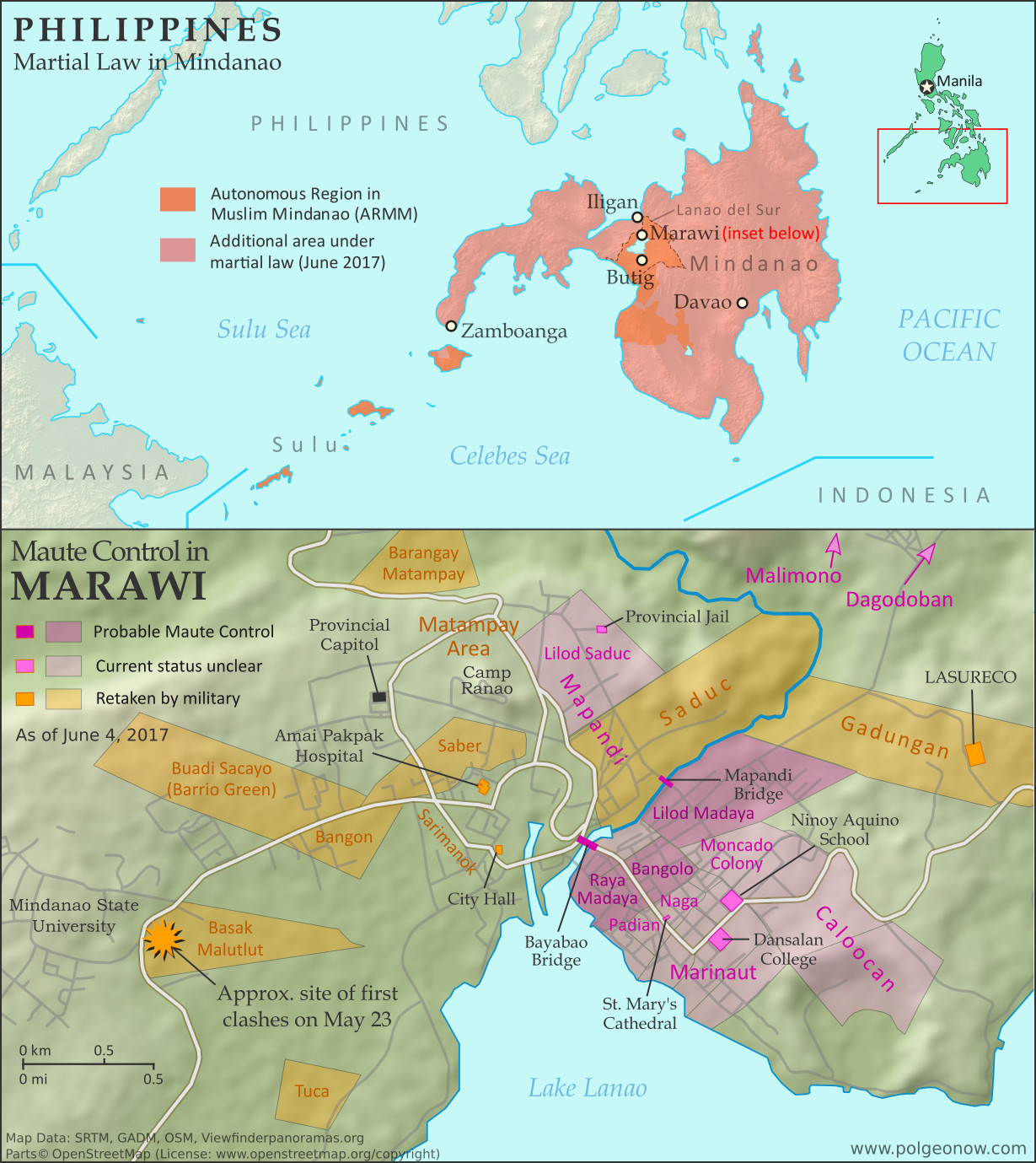
 |
Map by Evan Centanni. All rights reserved.
|
Updates on the world's countries and borders
Sunday, June 4, 2017
"Islamic State" in the Philippines? Detailed Control Map & Timeline of the Marawi Conflict
Saturday, May 27, 2017
Syria Control Map & Timeline: "De-escalation zones" & Continued IS Losses - May 2017 (Subscription)
SUBSCRIBERS CLICK HERE TO PROCEED TO ARTICLE AND MAP
There are newer versions of this map available. To see them, view all Syria updates.
Research by Djordje Djukic. Map by onestopmap.com, Evan Centanni, and Djordje Djukic
 The past month has seen continued territorial losses for the so-called "Islamic State"
(IS; formerly, ISIS/ISIL), as government and rebel forces take vast swaths of desert and a Kurdish-led coalition closes in on the group's capital. Meanwhile, foreign countries have begun drawing up provisional ceasefire zones along hardened lines between rebel and government control.
The past month has seen continued territorial losses for the so-called "Islamic State"
(IS; formerly, ISIS/ISIL), as government and rebel forces take vast swaths of desert and a Kurdish-led coalition closes in on the group's capital. Meanwhile, foreign countries have begun drawing up provisional ceasefire zones along hardened lines between rebel and government control.
See all this and more on the latest update to PolGeoNow's concise, professional Syrian Civil War control map, which includes a timeline of changes since our previous Syria map report in April, with sources cited.
This map and report are premium professional content, available to paid subscribers of the PolGeoNow Conflict Mapping Service.
Want to see before you subscribe? Check out our most recent FREE SAMPLE Syria map!
Exclusive report includes:
SUBSCRIBERS CLICK HERE TO PROCEED TO ARTICLE AND MAP
Not signed up yet? Click here to learn more about our professional subscription service!
Can I purchase just this map?
This map and report are not available for automated purchase to non-subscribers. If you need access or republication rights for only this map report, contact service@polgeonow.com for options.
There are newer versions of this map available. To see them, view all Syria updates.
Research by Djordje Djukic. Map by onestopmap.com, Evan Centanni, and Djordje Djukic
The past month has seen continued territorial losses for the so-called "Islamic State"
(IS; formerly, ISIS/ISIL), as government and rebel forces take vast swaths of desert and a Kurdish-led coalition closes in on the group's capital. Meanwhile, foreign countries have begun drawing up provisional ceasefire zones along hardened lines between rebel and government control.See all this and more on the latest update to PolGeoNow's concise, professional Syrian Civil War control map, which includes a timeline of changes since our previous Syria map report in April, with sources cited.
This map and report are premium professional content, available to paid subscribers of the PolGeoNow Conflict Mapping Service.
Want to see before you subscribe? Check out our most recent FREE SAMPLE Syria map!
Exclusive report includes:
- Up-to-date map of current territorial control in Syria, color-coded for the Assad government, rebel groups, "Islamic State" (ISIS/ISIL) fighters, and Kurdish/SDF forces. Colorblind accessible.
- Markers showing the approximate locations of Russian-Turkish-Iranian "de-escalation zones" and the one known US "deconfliction zone".
- Special symbols indicating towns dominated by rebels of the former Nusra Front (now Hayat Tahrir al-Sham) and US-backed Syrian Democratic Forces (SDF).
- Detailed indication of city-by-city control, including key towns and other locations important to current events.
- Locations of recent fighting and other important events, including Qaboun, Sawwana, Shaer gas fields, Jirah airbase, and more.
- Detailed timeline of important events and changes to territorial control since April 26, 2017, compiled by our Syria-Iraq expert, with links to sources.
SUBSCRIBERS CLICK HERE TO PROCEED TO ARTICLE AND MAP
Not signed up yet? Click here to learn more about our professional subscription service!
Can I purchase just this map?
This map and report are not available for automated purchase to non-subscribers. If you need access or republication rights for only this map report, contact service@polgeonow.com for options.
Thursday, May 18, 2017
Yemen Control Map & Report: May 2017 (Subscription)
SUBSCRIBERS CLICK HERE TO PROCEED TO ARTICLE AND MAP
There are newer versions of this map available. To see them, view all Yemen updates.

Timeline by Djordje Djukic. Map by Louis Martin-Vézian, Evan Centanni, and Djordje Djukic.
Since February, the Saudi-backed coalition supporting Yemen's internationally-recognized government has made some modest territorial gains against the Houthi government in two different areas, while Al Qaeda fighters still hold much of the country's east.
See all this and more on the newest update to PolGeoNow's Yemen territorial control map, which includes a timeline of changes and important events since our previous Yemen map report in late February.
This map and report are premium professional content, available to paid subscribers of the PolGeoNow Conflict Mapping Service.
Want to see before you buy? Check out our most recent FREE SAMPLE Yemen map report!
Exclusive report includes:
SUBSCRIBERS CLICK HERE TO PROCEED TO ARTICLE AND MAP
Not a member yet? Click here to learn more about our professional subscription service!
Can I purchase just this map?
This map and report are not available for automated purchase to non-subscribers. If you need access or republication rights for only this map report, contact service@polgeonow.com for options.
There are newer versions of this map available. To see them, view all Yemen updates.
Since February, the Saudi-backed coalition supporting Yemen's internationally-recognized government has made some modest territorial gains against the Houthi government in two different areas, while Al Qaeda fighters still hold much of the country's east.
See all this and more on the newest update to PolGeoNow's Yemen territorial control map, which includes a timeline of changes and important events since our previous Yemen map report in late February.
This map and report are premium professional content, available to paid subscribers of the PolGeoNow Conflict Mapping Service.
Want to see before you buy? Check out our most recent FREE SAMPLE Yemen map report!
Exclusive report includes:
- Up-to-date map of current territorial control in Yemen, color-coded for the pro-Hadi coalition, Houthi/Saleh forces, Al Qaeda in the Arabian Peninsula (AQAP), and the so-called "Islamic State" (ISIS/ISIL).
- Detailed indication of town-by-town control, including provincial boundaries, all major cities, and many smaller ones
- Markers for recent areas of fighting, including Mocha, Maydee, al-Zahari, Nihm, and others
- Timeline of changes to the situation since February 22, 2017, with links to sources
SUBSCRIBERS CLICK HERE TO PROCEED TO ARTICLE AND MAP
Not a member yet? Click here to learn more about our professional subscription service!
Can I purchase just this map?
This map and report are not available for automated purchase to non-subscribers. If you need access or republication rights for only this map report, contact service@polgeonow.com for options.
Tuesday, May 9, 2017
The Gambia Changes Its Name Back
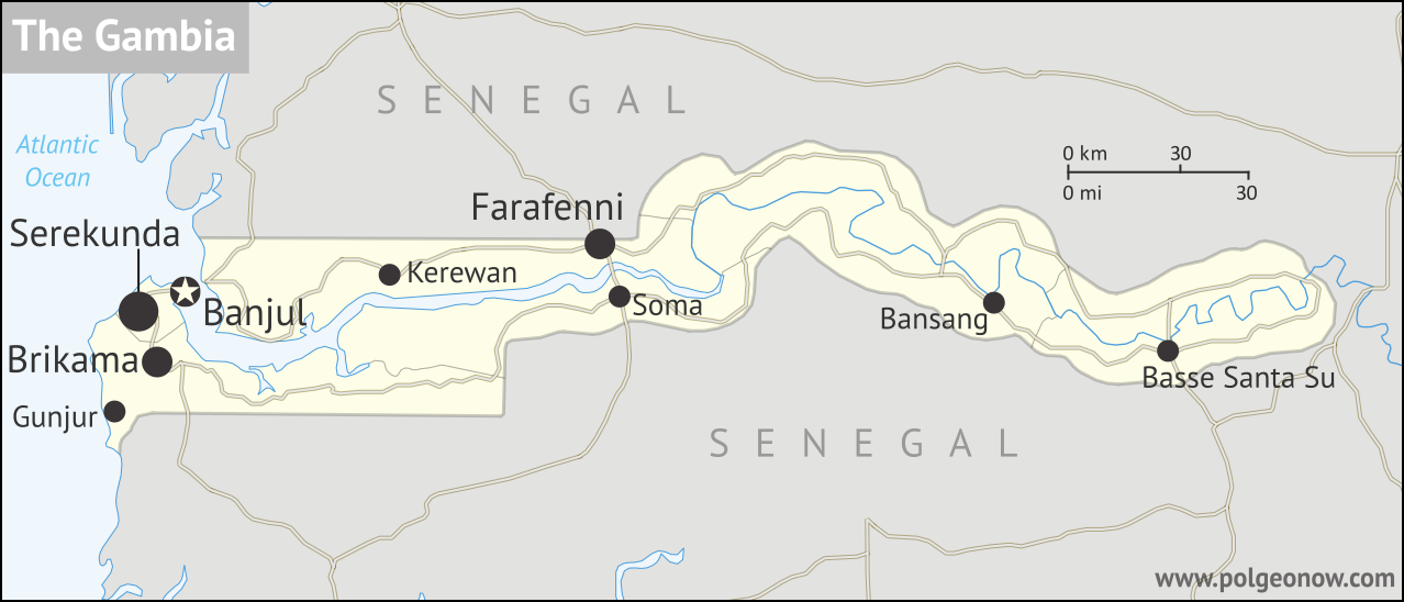 |
| Map by Evan Centanni. Contact for usage rights. |
Gambia Name Change Reversal
Last year we reported on how the Gambia, a tiny country located along the banks of a river in West Africa, had changed its official name at the UN. The country's maverick dictator had decided in 2015 to switch from "Republic of The Gambia" to "Islamic Republic of The Gambia".Saturday, May 6, 2017
The Maldives' Withdrawal from the Commonwealth
 |
| Map by Evan Centanni, modified from public domain blank world map |
Subscribe to:
Posts (Atom)