Monday, July 25, 2016

Syrian Civil War Control Map & Report: July 2016 (Subscription)

MEMBERS CLICK HERE TO PROCEED TO ARTICLE AND MAP

There are newer versions of this map available. To see them, view all Syria updates.

Research by Djordje Djukic. Map by onestopmap.com, Evan Centanni, and Djordje Djukic

Subscribe for full access to all conflict map reports!

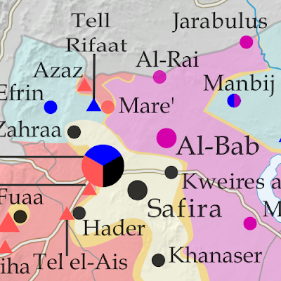
Map of fighting and territorial control in Syria's Civil War (Free Syrian Army rebels, Kurdish YPG, Syrian Democratic Forces (SDF), Al-Nusra Front, Islamic State (ISIS/ISIL), and others), updated for July 2016. Now includes terrain and major roads (highways). Highlights recent locations of conflict and territorial control changes, such as Manbij, Abu Kamal (Al Bukamal), Aleppo, Daraya, Kinsabba and more (color blind accessible). The past month has seen territorial gains both for Syria's Assad government and for rebel forces, while the so-called "Islamic State" (ISIS/ISIL) has mostly held its ground.
 
See all this and more on the latest update to PolGeoNow's concise, professional Syrian Civil War control map, which includes a timeline of changes since our previous Syria map report in late June, with sources cited.

This map and report are premium professional content, available to paid subscribers of the PolGeoNow Conflict Mapping Service.

Want to see before you subscribe? Check out our most recent FREE SAMPLE Syria map!

Exclusive map report includes:
  • Up-to-date map of current territorial control in Syria, color-coded for the Assad government, rebel groups, "Islamic State" (ISIS/ISIL) fighters, and Kurdish/SDF forces (color blind accessible).
  • Special symbols indicating towns dominated by rebels of Al Qaeda affiliate Jabhat al-Nusra (the Nusra Front) and US-backed Syrian Democratic Forces (SDF).
  • Detailed indication of city-by-city control, highlighting key towns and other locations important to current events.
  • Locations of recent fighting and military operations, including Manbij, Abu Kamal (Al Bukamal), Daraya, Kinsabba, and more.
  • Detailed timeline of important events and changes to territorial control since June 26, 2016, compiled by our Syria-Iraq expert, with links to sources.

MEMBERS CLICK HERE TO PROCEED TO ARTICLE AND MAP

Not a member yet? Click here to learn more about our professional subscription service!

Can I purchase just this map?
This map and report are not available for automated purchase to non-subscribers. If you need access or republication rights for only this map report, contact service@polgeonow.com for options.

Friday, July 1, 2016

Iraq Control Map & Report: July 2016 (Subscription)

MEMBERS CLICK HERE TO PROCEED TO ARTICLE AND MAP

There are newer versions of this map available. To see them, view all Iraq updates.

Research by Djordje Djukic. Map by onestopmap.com, Evan Centanni, and Djordje Djukic

Subscribe for full access to all conflict map reports!

Detailed map of territorial control in Iraq as of June 30, 2016, including territory held by the so-called Islamic State (ISIS, ISIL), the Baghdad government, and the Kurdistan Peshmerga. Includes recent flashpoints such as Fallujah, Karma, Saqlawiyah, and Akashat. (color blind accessible) The Iraqi army and allies have driven the so-called "Islamic State" (ISIS/ISIL) out of Fallujah, its last stronghold in central Iraq, even as it continues to lose ground on other fronts.
 
See all this and more on the latest update to PolGeoNow's concise, professional map of control in Iraq's civil war, including a timeline of changes since our previous Iraq map report of May 2016.

This map and report are premium professional content, available to paid subscribers of the PolGeoNow Conflict Mapping Service.

Want to see before you subscribe? Check out our most recent FREE SAMPLE Iraq map report!

Exclusive map report includes:
  • Up-to-date map of current territorial control in Iraq, color-coded for the Iraqi government, "Islamic State" (ISIS/ISIL) extremists, and Kurdistan's Peshmerga forces
  • Detailed indication of town-by-town control, including provincial boundaries, all major cities, and many smaller ones
  • Markers for key areas of recent fighting such as Fallujah, Karma, Saqlawiyah, and Akashat
  • Timeline of changes to the situation since mid-May, compiled by our Iraq specialist, with links to sources 
  • New since last year: Terrain shading and major highways included on map for geographic context

MEMBERS CLICK HERE TO PROCEED TO ARTICLE AND MAP

Not a member yet? Click here to learn more about our professional subscription service!

Can I purchase just this map?
This map and report are not available for automated purchase to non-subscribers. If you need access or republication rights for only this map report, contact service@polgeonow.com for options.

Thursday, June 30, 2016

Map of European Union Member Countries Before Brexit (2014-2020)

There are newer editions of this map available. To see the most recent, visit our European Union explainer article.


Map of the European Union, including all member countries, official candidate countries, and potential candidate countries, as of June 2016, pre-Brexit (colorblind accessible). Also file under: Map of EU Member Countries.
The UK is still part of the EU for now, since the vote to leave hasn't been implemented yet.
Map by Evan Centanni, from blank map by Ssolbergj. License: CC BY-SA

EU Member Countries Pre-Brexit


This is an archived version of our map of European Union (EU) member and candidate countries, from before the UK's departure (known as "Brexit"). It's accurate for the period from June 2014, when Albania was recognized as an EU candidate country, to January 31, 2020, when the United Kingdom (UK) officially left the organization. The most recent country to join as a full member was Croatia in 2013.

For the current edition of this map, check out our updated feature article: Which Countries are in the European Union, Which Aren't, and Which Want to Join?

Tuesday, June 28, 2016

Syrian Civil War Control Map & Report: June 2016 (Subscription)

MEMBERS CLICK HERE TO PROCEED TO ARTICLE AND MAP

There are newer versions of this map available. To see them, view all Syria updates.

Research by Djordje Djukic. Map by onestopmap.com, Evan Centanni, and Djordje Djukic

Subscribe for full access to all conflict map reports!

Map of fighting and territorial control in Syria's Civil War (Free Syrian Army rebels, Kurdish YPG, Syrian Democratic Forces (SDF), Al-Nusra Front, Islamic State (ISIS/ISIL), and others), updated for June 2016. Now includes terrain and major roads (highways). Highlights recent locations of conflict and territorial control changes, such as Manbij, Mare, Tanf border crossing, Thawra/Tabqa, Arak, and more. A lot has happened in Syria in the past month, with major SDF and Syrian Army advances against the so-called "Islamic State" (ISIS/ISIL), as well as various smaller changes to rebel control.
 
See all this and more on the latest update to PolGeoNow's concise, professional Syrian Civil War control map, which includes a timeline of changes since our previous Syria map report in mid-May.

This map and report are premium professional content, available to paid subscribers of the PolGeoNow Conflict Mapping Service.

Want to see before you subscribe? Check out our most recent FREE SAMPLE Syria map!

Exclusive map report includes:
  • Up-to-date map of current territorial control in Syria, color-coded for the Assad government, rebel groups, "Islamic State" (ISIS/ISIL) extremists, and Kurdish/SDF forces. 
  • Special symbols indicating towns dominated by rebels of Al Qaeda affiliate Jabhat al-Nusra (the Nusra Front) and US-backed Syrian Democratic Forces (SDF).
  • Detailed indication of city-by-city control, highlighting key towns and other locations important to current events.
  • Locations of recent fighting and military operations, including Manbij, Thawra (Tabqa), Mare, Tanf border crossing, Arak, and more.
  • Detailed timeline of important events and changes to territorial control since May 13, 2016, compiled by our Syria-Iraq expert, with links to sources.

MEMBERS CLICK HERE TO PROCEED TO ARTICLE AND MAP

Not a member yet? Click here to learn more about our professional subscription service!

Can I purchase just this map?
This map and report are not available for automated purchase to non-subscribers. If you need access or republication rights for only this map report, contact service@polgeonow.com for options.
Friday, June 24, 2016

UK Votes to Quit EU: Map of How Britain Voted in the Brexit Referendum


By Evan Centanni

UK Brexit vote map: Map of election results in Britain's June 2016 referendum on leaving the European Union (EU). Continuous red-to-blue color scheme gives a more honest depiction of the similarities between different election districts. Colorblind accessible.
Map of election results in the UK's "Brexit" referendum. Modified by Evan Centanni from Wikimedia map by Mirrorme22, Nilfanion, TUBS, and Sting (CC BY-SA).

Brexit by Constituency

The results are in for yesterday's referendum on UK membership in the European Union, and the winner is "Leave". Brits voted by a margin of 52% to 48% in favor of exiting the European Union, making a "Brexit" (British exit from the EU) more or less guaranteed in the coming years. Britain will become the first member country ever to leave the EU, and the British overseas territory of Gibraltar is expected to get pulled out with it.

Learn More: Brexit: 9 Geography Facts You Should Know About the Referendum and Britain's EU Membership

Who Voted to Stay

Voter tendencies varied a lot from place to place. Support for the "Remain" side was strong across Scotland, culturally Irish parts of Northern Ireland, the London area, and a handful of other cities in England (led by Cambridge, Oxford, and Brighton).

By far the greatest show of support for Remain was a win by 96% in Gibraltar - which isn't even in the UK proper, but got to vote because of its unique status as a British external territory that's in the EU.