 |
| Click to enlarge: Countries recognizing the State of Palestine in green, with most recent addition highlighted. Palestine in magenta (circled). Map by Evan Centanni, modified from public domain graphic (source). |
Updates on the world's countries and borders
Friday, June 5, 2015
Vatican City Administration Recognizes Palestine as a Country (map)
(Keep up with changes to Palestine's situation: view all Palestine updates.)
Subscribers click here to view this article in the ad-free members area. Not a member yet? Subscribe now!
Thursday, May 28, 2015
Map of Boko Haram Control in Nigeria: May 2015 (Subscription)
The best online map of Boko Haram's territorial control - guaranteed!
There are newer versions of this map available. To see them, view all Boko Haram updates.

Timeline by T.H., with additional reporting by Evan Centanni
Even as evidence mounts of Boko Haram's ties to the Islamic State, the Nigerian rebel group has been driven from most of its recently-held territory. Yet as Nigeria's new president prepares to take office, Boko Haram may already be making a comeback.
This map report illustrates areas of known and possible Boko Haram control in Nigeria, and for the first time shows the full area of the Sambisa Forest, the rebels' last-resort hideout. The report includes a summary and timeline of events since our previous Boko Haram control map in March.
This map report is exclusive premium content, available to paid subscribers or for separate purchase. Buy now (US$14.99)
Exclusive map report includes:
MEMBERS CLICK HERE TO PROCEED TO ARTICLE AND MAP
NOT A MEMBER YET? SUBSCRIBE NOW!
There are newer versions of this map available. To see them, view all Boko Haram updates.

Download PDF: Buy now |
Even as evidence mounts of Boko Haram's ties to the Islamic State, the Nigerian rebel group has been driven from most of its recently-held territory. Yet as Nigeria's new president prepares to take office, Boko Haram may already be making a comeback.
This map report illustrates areas of known and possible Boko Haram control in Nigeria, and for the first time shows the full area of the Sambisa Forest, the rebels' last-resort hideout. The report includes a summary and timeline of events since our previous Boko Haram control map in March.
This map report is exclusive premium content, available to paid subscribers or for separate purchase. Buy now (US$14.99)
Exclusive map report includes:
- Map of Boko Haram's overall area of control in Nigeria, updated to May 28, 2015.
- Detailed mapping of each town under Boko Haram's influence, as well as most locations of recent attacks.
- New: Full outline of the Sambisa Forest, Boko Haram's vast safe haven.
- Summary and detailed timeline of territorial changes and major events since late March, with links to sources.
MEMBERS CLICK HERE TO PROCEED TO ARTICLE AND MAP
NOT A MEMBER YET? SUBSCRIBE NOW!
Tuesday, May 26, 2015
Syria Civil War Control Map: May 2015 (Subscription)
There are newer versions of this map available. To see them, view all Syria updates.

Research by T.H., with additional reporting by Evan Centanni
Since just last month, the Syrian government of Bashar al-Assad has lost important ground to both the rebel coalition (including Al Qaeda affiliate Jabhat al-Nusra) and the Islamic State. The war has also spread into new parts of Syria previously untouched by fighting, while Kurdish groups in the north are continuing to consolidate their gains.
See all this and more on the newest update to PolGeoNow's popular Syria control map, and read a timeline of changes since our previous Syria map report in mid-April.
This map and report are exclusive premium content, available to paid subscribers or for separate purchase.
Download PDF (US$19.99)
Exclusive map report includes:
MEMBERS CLICK HERE TO PROCEED TO ARTICLE AND MAP
NOT A MEMBER YET? SUBSCRIBE NOW!

Download PDF: Buy now |
Since just last month, the Syrian government of Bashar al-Assad has lost important ground to both the rebel coalition (including Al Qaeda affiliate Jabhat al-Nusra) and the Islamic State. The war has also spread into new parts of Syria previously untouched by fighting, while Kurdish groups in the north are continuing to consolidate their gains.
See all this and more on the newest update to PolGeoNow's popular Syria control map, and read a timeline of changes since our previous Syria map report in mid-April.
This map and report are exclusive premium content, available to paid subscribers or for separate purchase.
Download PDF (US$19.99)
Exclusive map report includes:
- Up-to-date map of current territorial control in Syria, color-coded for the Assad government, rebel groups, Islamic State (ISIS/ISIL) extremists, and Kurdish self-protection forces. Special symbol indicates rebel-held towns dominated by Al Qaeda affiliate Jabhat al-Nusra.
- Detailed indication of city-by-city control, highlighting key towns and other locations relevant to current events.
- Locations of recent fighting and military operations, including Palmyra, Jisr al-Shughur, Yarmouk, al-Tanf border crossing, and more.
- Timeline of important events and changes to territorial control since April 10, 2015.
MEMBERS CLICK HERE TO PROCEED TO ARTICLE AND MAP
NOT A MEMBER YET? SUBSCRIBE NOW!
Friday, May 22, 2015
War in Iraq: Map of Islamic State Control in May 2015
There are newer versions of this map available. To see them, view all Iraq updates.
This is a free sample of our Iraq territorial control map. To access more Iraq control map updates like this one, sign up now for our conflict map subscription service!
Subscribers click here to view this article in the ad-free members area. Not a member yet? Subscribe now!
Timeline by Djordje Djukic, with additional reporting by Evan Centanni
A City for a City
Since PolGeoNow published our February map of control in Iraq, two major cities have changed hands, in opposite directions. Tikrit, known as the home region of former leader Saddam Hussein, was the Islamic State's farthest-forward prize in its spectacular takeover of northern Iraq last June. A priority for Iraq's struggling Baghdad government, Tikrit was finally taken back this March and April in a major push by Shiite militias, led by Iran and ultimately supported by U.S.-Arab coalition airstrikes.
This is a free sample of our Iraq territorial control map. To access more Iraq control map updates like this one, sign up now for our conflict map subscription service!
 |
Timeline by Djordje Djukic, with additional reporting by Evan Centanni
A City for a City
Since PolGeoNow published our February map of control in Iraq, two major cities have changed hands, in opposite directions. Tikrit, known as the home region of former leader Saddam Hussein, was the Islamic State's farthest-forward prize in its spectacular takeover of northern Iraq last June. A priority for Iraq's struggling Baghdad government, Tikrit was finally taken back this March and April in a major push by Shiite militias, led by Iran and ultimately supported by U.S.-Arab coalition airstrikes.
Thursday, May 14, 2015
Map: Another Country Joins the "Eurasian Union" (May 2015)
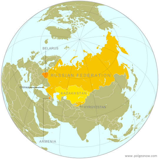 |
| The Eurasian Economic Union's five current member countries, plus disputed Crimea, claimed to be part of Russia. Map by Evan Centanni, starting from this map by Keverich2. License: CC BY-SA |
Subscribe to:
Posts (Atom)