 |
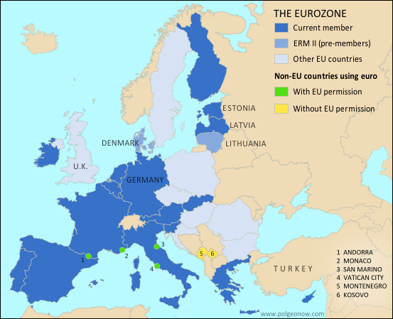
| The Eurozone, European Union, and other countries using the euro. Map by Evan Centanni, from blank map by Ssolbergj. License: CC BY-SA |
Updates on the world's countries and borders
Thursday, August 28, 2014
Latvia Joins the Eurozone (map)
This article was originally published as "Map: Which Countries Use the Euro? (Plus: This Year's New Addition)". To see newer versions of the map, view all Eurozone articles on PolGeoNow.
Premium members click here to view this article in the ad-free members area. Not a member yet? Subscribe now!
Thursday, August 21, 2014
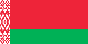
Belarus's Quiet Flag Change
Sometimes geopolitical changes make headlines, but other times they slip quietly under the radar. Such is the case with the flag of Belarus, which was changed without fanfare (or explanation) by a government decree back in 2012. We don't want you to miss any changes to the world's list of countries and flags, so we now present a belated report on this little-known event.
Premium members click here to view this article in the ad-free members area. Not a member yet? Subscribe now!
By Caleb Centanni
Belarus, a former Soviet state in Eastern Europe, made a slight change to its flag in early 2012. On Feb. 10 of that year, the State Committee for the Standardization of the Republic of Belarus announced a minor change to the ornamental pattern on the left margin of the flag.
The pattern originally occupied one-twelfth of the flag's total length, and was located inside a white margin making up one-ninth of the flag design. The ornamental pattern has now been extended to fill the entire one-ninth margin. The Belarusian government apparently provided no specific reason for the change.
Other than this minor adjustment, the current flag of Belarus has been in place since 1995, when it replaced the traditional white-red-white flag after a controversial referendum that critics denounced as unconstitutional.
Belarusian President Alexander Lukashenko supported the adoption of the 1995 flag, which is very similar to the Soviet-era flag. State-owned media argued the traditional tricolor flag was unacceptable due to its use by Nazi collaborators in World War II.
Premium members click here to view this article in the ad-free members area. Not a member yet? Subscribe now!
|
.png)
.png)
Belarus, a former Soviet state in Eastern Europe, made a slight change to its flag in early 2012. On Feb. 10 of that year, the State Committee for the Standardization of the Republic of Belarus announced a minor change to the ornamental pattern on the left margin of the flag.
The pattern originally occupied one-twelfth of the flag's total length, and was located inside a white margin making up one-ninth of the flag design. The ornamental pattern has now been extended to fill the entire one-ninth margin. The Belarusian government apparently provided no specific reason for the change.
Other than this minor adjustment, the current flag of Belarus has been in place since 1995, when it replaced the traditional white-red-white flag after a controversial referendum that critics denounced as unconstitutional.
Belarusian President Alexander Lukashenko supported the adoption of the 1995 flag, which is very similar to the Soviet-era flag. State-owned media argued the traditional tricolor flag was unacceptable due to its use by Nazi collaborators in World War II.
Monday, August 18, 2014
Syria Civil War Map: August 2014 (#13)
There are newer versions of this map available. To see them, view all Syria updates.
Premium subscribers have already seen our new Syria map format, which shows full areas of control for each major faction in the civil war. Now, we present this month's update free of charge for your convenience.
To get many more Syrian Civil War map updates like this one, sign up now for a premium subscription!
Premium members click here to view this article in the ad-free members area.
Threats from All Sides
Since our last Syria map update in early July, the lines of control in the civil war have not changed drastically. However, fighting on all fronts has resulted in numerous small but important changes to the situation, as the Assad government is now facing serious challenges from both the newly rebranded Islamic State (formerly ISIS/ISIL) and a loose coalition of various other rebel groups (including both the Free Syrian Army and Al-Nusra).
Premium subscribers have already seen our new Syria map format, which shows full areas of control for each major faction in the civil war. Now, we present this month's update free of charge for your convenience.
To get many more Syrian Civil War map updates like this one, sign up now for a premium subscription!
 |
Territorial control in the Syrian Civil War as of August 2014. Map by Evan Centanni, starting from blank map by NordNordWest. License: CC BY-SA
|
Threats from All Sides
Since our last Syria map update in early July, the lines of control in the civil war have not changed drastically. However, fighting on all fronts has resulted in numerous small but important changes to the situation, as the Assad government is now facing serious challenges from both the newly rebranded Islamic State (formerly ISIS/ISIL) and a loose coalition of various other rebel groups (including both the Free Syrian Army and Al-Nusra).
Sunday, August 10, 2014
Iraq Conflict Control Map: August 2014 (Premium)
There are newer versions of this map available. To see them, view all Iraq updates.

This is the latest update to our series of maps
documenting territorial control in the current war in Iraq, with a
number of updates since the previous edition
in late June.
It includes control by the Maliki goverment, Kurdish forces, and the Islamic State (formerly known as ISIS), and has been re-styled to fit seamlessly with our popular control maps of the Syrian Civil War.
This map and article are exclusive premium content, available only to paid members or for individual purchase. Buy now (US$9.99)
Premium map includes:
MEMBERS CLICK HERE TO PROCEED TO ARTICLE AND MAP
NOT A MEMBER YET? SUBSCRIBE NOW!

Download PDF buy |
It includes control by the Maliki goverment, Kurdish forces, and the Islamic State (formerly known as ISIS), and has been re-styled to fit seamlessly with our popular control maps of the Syrian Civil War.
This map and article are exclusive premium content, available only to paid members or for individual purchase. Buy now (US$9.99)
Premium map includes:
- Up-to-date map of current territorial control in Iraq, color-coded for the Maliki government, ISIS/Islamic State extremists, and Kurdish forces
- Detailed indication of city-by-city control, highlighting key towns relevant to current events
- Includes recent areas of fighting including Sinjar, Qaraqosh, Mosul Dam, Erbil province, and more
- In-depth article summarizes changes since June, including ISIS's declaration of an Islamic caliphate, with links to sources
MEMBERS CLICK HERE TO PROCEED TO ARTICLE AND MAP
NOT A MEMBER YET? SUBSCRIBE NOW!
Tuesday, July 29, 2014
African Union Reinstates Egypt and Guinea-Bissau (Map)
 |
| The African Union as of July 2014. Map by Evan Centanni, from this blank map by Eric Gaba. License: CC BY-SA |
Subscribe to:
Posts (Atom)