Showing posts with label caribbean. Show all posts

Saturday, July 16, 2022

Nicaragua v. Colombia: World Court Orders Sea Map Adjustments

Map of Colombia's claimed Integral Contiguous Zone around San Andres, Providencia and its other islands in the Caribbean Sea north of Panama and east of Nicaragua, which was one of the main subjects of dispute with Nicaragua in the Nicaragua v. Colombia World Court case that concluded in April 2022 with a judgement from the International Court of Justice (ICJ) in the Hague. At the center of the map is a large purple blob representing the so-called integral contiguous zone, surrounding each island's 12-mile territorial sea and 24-mile normal contiguous zone and filling the gaps between them. Importantly, this integral contiguous zone overlaps the sea border drawn between Colombia and Nicaragua by the ICJ in 2012. Colorblind accessible.
Modified by PolGeoNow from map included in public court documents (original created by International Mapping).

Latest World Court Ruling: Nicaragua v. Colombia Sea Dispute

Judgments handed down by the UN's International Court of Justice (ICJ) - also known by semi-official nickname "the World Court" - can be pretty interesting to political geography nerds like us. Often they establish new land and sea borders or end long-running territorial disputes, as you might have seen in our past coverage of the Burkina Faso/Niger, Peru v. Chile, Costa Rica v. Nicaragua, and Somalia v. Kenya cases.

Saturday, December 4, 2021

Barbados Abolishes its Monarchy, Firing Queen Elizabeth

Map countries with Queen Elizabeth II as head of state, which are known as the Commonwealth realms. Includes the UK, Canada, Australia, and a number of small countries in Oceania and the Caribbean. Also shows former Commonwealth realms, including large parts of Africa and South Asia. Colorblind accessible.
Updated map of the Commonwealth realms (independent countries that share the monarchy with Britain). Click to enlarge. Contact us for permission to use this map.
 

Map showing the location of Barbados in the eastern Caribbean. A string of islands extends east from Cuba then south to the northern edge of South America, with the island of Barbados located off to the east side of the string near the southern end.
Location of Barbados in the eastern Caribbean (circled, at far right). Public domain graphic (source).
Barbados Stops Being a Commonwealth Realm

As long-time readers of PolGeoNow know, Queen Elizabeth II isn't just the queen of England and the UK, but also reigns separately over quite a few other countries known as the "Commonwealth realms". 

Until Tuesday, there were 16 independent countries recognizing Elizabeth II as their queen. But now, after the legislature of Caribbean island country Barbados voted to remove the monarchy from its constitution - effective November 30, 2021 - that number has fallen to just 15.

Thursday, October 29, 2020

Puerto Rico: 52nd State of the US? (2020 Referendum - Updated with Results)

In 2012, we reported on Puerto Rico's chances at becoming the a state of the US, after the territory's people sort of voted for that. This is an updated and expanded version of that article, fully revised for next week's new Puerto Rico statehood referendum. 

Continue reading to learn why this time might be different, and why Puerto Rico could become the 52nd state of the US instead of the 51st!

For updates on the results of the referendum, scroll to the bottom of this article.


Puerto Rico Statehood Vote: Different This Time

The US territory of Puerto Rico. (Public domain map from CIA World Factbook)

The US territory of Puerto Rico, made up of one large island and several smaller ones in the Caribbean, doesn't have any say in next week's US presidential election. 

But its people will still have something important to vote on next Tuesday: a referendum on whether to fully join the US as one of the country's states. 

Like in previous votes, the result is non-binding: It can only take effect if approved by the US government. But that doesn't mean it's just a symbolic move.

FAQ: What is Puerto Rico? Is it part of the United States? (Updated)

It's 2020, and Puerto Rico is voting again on whether to become a state of the United States. But what exactly is it now? Is Puerto Rico part of the United States, and can its people vote in US elections? Find all your answers here! 

This is a revised and expanded version of an explainer we originally published in November 2012.

Is Puerto Rico a state of the US? If not, then what is it?

The US territory of Puerto Rico. (Public domain map from CIA World Factbook)
Puerto Rico, a Spanish-speaking island region in the Caribbean, is a United States territory, but not one of the country's 50 states. 

Since it was taken from Spain in the Spanish-American War of 1898, Puerto Rico has been an overseas territory of the United States (known in US legal jargon as an "insular area").  

Friday, April 24, 2020

Update: Belize vs. Guatemala Dispute

A PolGeoNow News Brief

Guatemala-Belize territorial dispute: Approximate map of what parts of Belize are claimed by Guatemala.
One interpretation of Guatemala's territorial claims. The precise lines of the dispute will be laid out as the court case continues. (Wikimedia map by Janitoalevic and Bettyreategui; CC BY-SA)
Editor's Note: This article has been updated on April 29, 2020 to reflect corrections to the timeline - the details of Guatemala's claims will likely not be publicly available until mid-2024, even later than we had previously implied.

Last year, we reported that Belize and Guatemala were going to the UN's International Court of Justice (ICJ) to finally resolve their longstanding border dispute, which involves Guatemala claiming much of the land governed by neighboring Belize. So what's going on with that now?

So far, both countries are still preparing their cases. The next step is for Guatemala to submit its "memorial" to the court - a report laying out its position on the issues at stake. That document should be pretty interesting, because it will clarify exactly which land and sea areas Guatemala is claiming the rights to, and by extension, where exactly the lines of the two countries' territorial dispute lie.

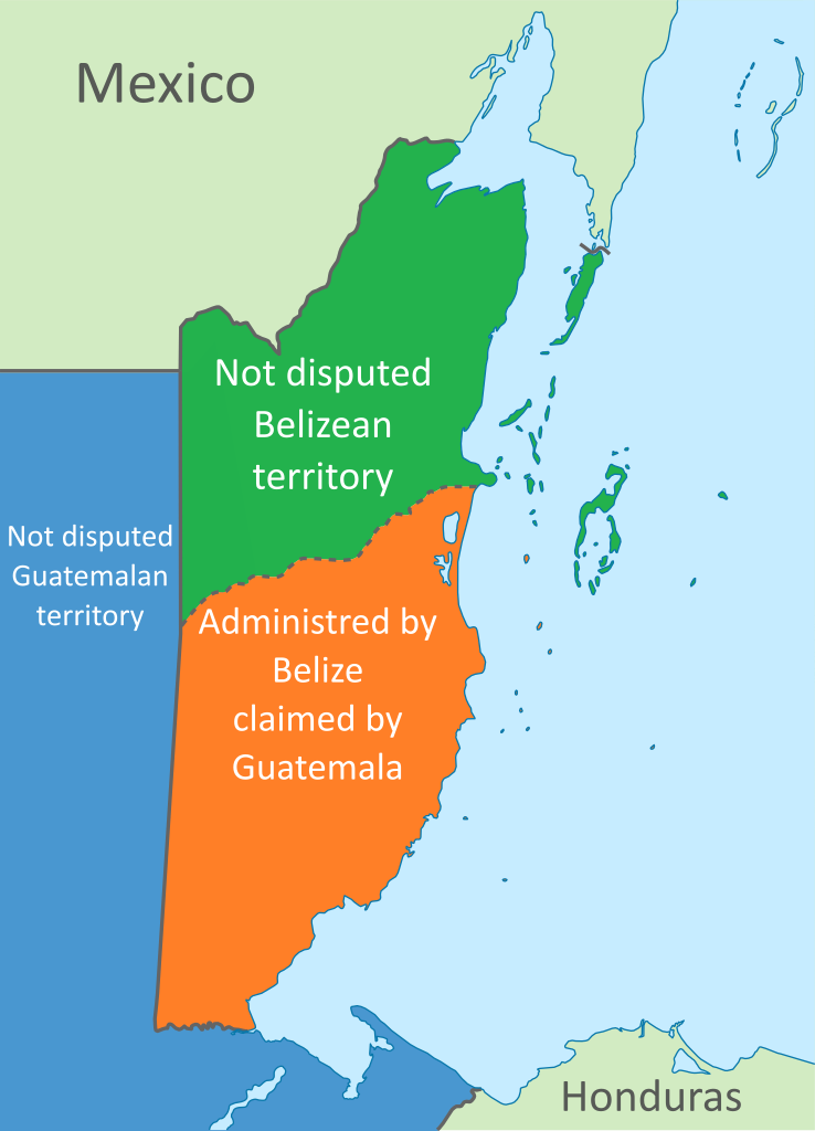
For now, Guatemala's claims are a little bit vague, with some interpretations concluding that the country claims more than half of the land now controlled by Belize (see map at right). But we'll have to wait awhile yet to get the details - the deadline for Guatemala to submit its memorial was originally going to be June 8 of this year, but because of delays Guatemala says are related to the coronavirus pandemic, the court has agreed to extend the deadline by one year, to June 2021.

And the court doesn't usually release the written memorials to the public until hearings begin, which means we'll have to wait until after Belize responds, and likely until each country has responded once more, before actually seeing the details of Guatemala's memorial (thanks to Bordermap Consulting for that correction). Belize, for its part, thought Guatemala should only get a two-month extension, but the court decided let Guatemala have the extra time. Once Guatemala's memorial is submitted, Belize will have one more year - until June 2022 - to submit its own "counter-memorial", a report on its own official positions and responses to Guatemala's claims.

Taking all this into account, it's likely that hearings in the case won't start until mid-2024, meaning we still have to wait four more years to learn the details of Guatemala's claims, and even longer to find out how the court will settle the dispute.

Want to check for updates to our coverage of this case? View all ICJ articles on PolGeoNow to see the latest!

Wednesday, July 10, 2019

Belize and Guatemala Go to Court

You can view all ICJ articles on PolGeoNow for updates to this case.

Map: Where is Belize and where is Guatemala? Location in Central America.
Guatemala and Belize's location in Central America
(Wikimedia map by DO56, Rei-artur, and Vardion; CC BY-SA)
 
A PolGeoNow News Brief

Guatemala-Belize territorial dispute: Approximate map of what parts of Belize are claimed by Guatemala.
One interpretation of Guatemala's territorial claims. The precise lines of the dispute will be laid out as the court case continues. (Wikimedia map by Janitoalevic and Bettyreategui; CC BY-SA)
The Central American republic of Guatemala has claimed much of the land governed by neighboring Belize ever since the mid-1800s, at some times even claiming the whole country as Guatemalan territory. Now, the two neighbors have finally agreed to settle the dispute once and for all by taking it to the UN's International Court of Justice (ICJ).

The two countries officially registered their case with the court last month, after both countries' people voted in favor of the move in nationwide referendums. Of the 27% of Guatemalans who voted, 96% were in favor of going court. In Belize, voter turnout was 65%, of which 55% voted in favor.

Belize has vigorously denied Guatemala's claims for over a century, but in exchange for putting the issue to rest, it's agreed to let the court redraw its borders if the justices decide in favor of Guatemala. The two countries have also agreed to let the court draw the boundary between their respective territories and economic zones at sea.

What exactly does Guatemala claim today? It's actually not completely clear. By some interpretations, Belize's current area could be cut in half if the court sided with Guatemala. But the exact lines of Guatemala's claims should be clarified soon as both countries bring their official arguments to the court...

Want to see more PolGeoNow coverage as this case unfolds? Let us know with a comment on Twitter or Facebook!

Tuesday, July 31, 2018

Wednesday, February 17, 2016

Map: Which Countries Recognize Palestine as Independent in 2016?

(Keep up with changes to Palestine's situation: view all Palestine updates.)

Map of countries that recognize the State of Palestine as an independent country, updated for February 2016 with recent addition Saint Lucia highlighted
Click to enlarge. Palestine in magenta (circled). Map by Evan Centanni, modified from public domain graphic (source).
Subscribers click here to view this article in the ad-free members area. Not a member yet? Learn about PolGeoNow subscriptions!

Thursday, February 12, 2015

Map: ALBA Has 2 New Member Countries

Subscribers click here to view this article in the ad-free members area. Not a member yet? Subscribe now!

Map of the Bolivarian Alliance for the Peoples of Our Americas (ALBA), showing full member countries, including new members Grenada and Saint Kitts and Nevis, as well as special guest members (colorblind accessible).
The Bolivarian Alliance for the Peoples of Our America (ALBA). Map by Evan Centanni.

Tuesday, November 27, 2012

Puerto Rico: 51st State of the U.S.?

[This article was written after Puerto Rico's 2012 status referendum. In June 2017, Puerto Rico voted in another controversial referendum, again technically in favor of statehood. Most of this five-year-old article is still accurate after the 2017 vote. -Editor]


Earlier this month, papers reported that Puerto Rico had voted to become a state of the U.S. - but will it really happen? What does it take to become a state, anyway? Last time, we explained Puerto Rico's current status - now for answers about the territory's future....

Flag of the United States with a new star added (total of 51 stars) for a hypothetical new state of Puerto Rico
A possible 51-star U.S. flag. Since each star on the flag represents one state, a new one would need to be added for Puerto Rico (public domain; source).
Why would Puerto Rico want to become a state?
Puerto Rico's current situation leaves it disadvantaged compared to the states. It has its own constitution and government, but the laws establishing them are subject to approval by the U.S. Congress. And despite the fact that most federal taxes and other laws apply to Puerto Ricans, residents have no real representation in Congress and no say in the presidential election. (For more details, see What is Puerto Rico?)